
Ecological security pattern of the oasis area around the Tarim Basin based on coupled ecosystem services and landscape connectivity
Received date: 2024-01-10
Revised date: 2024-02-20
Online published: 2026-03-11
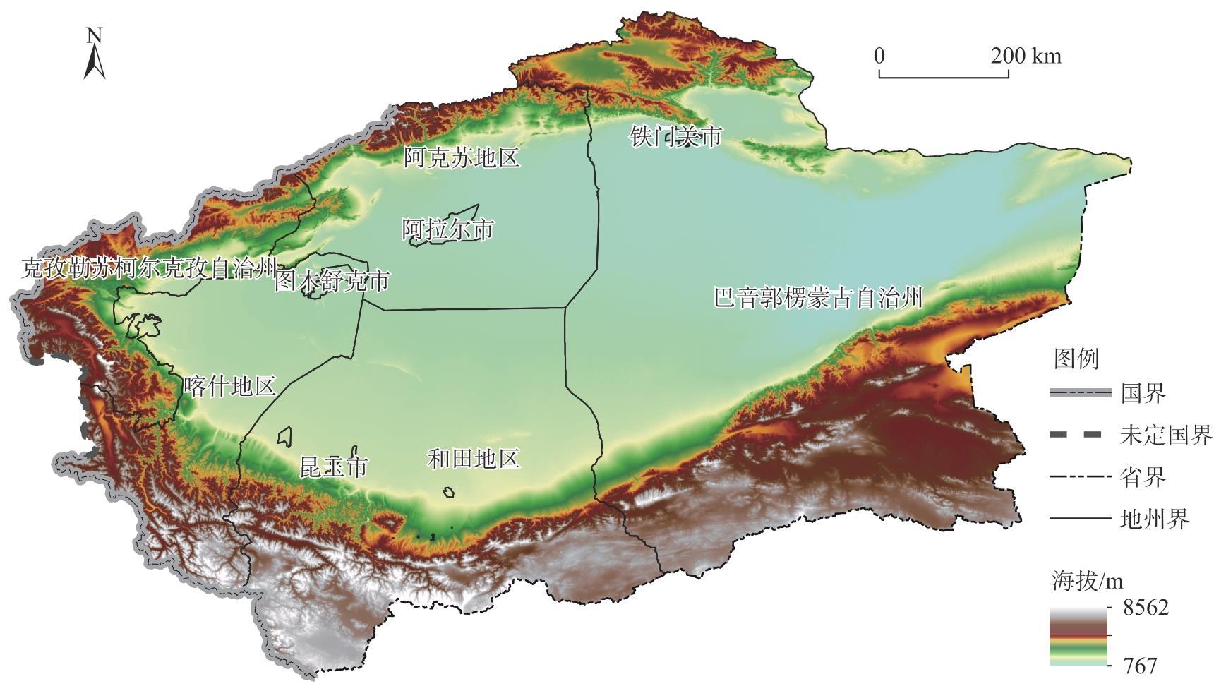
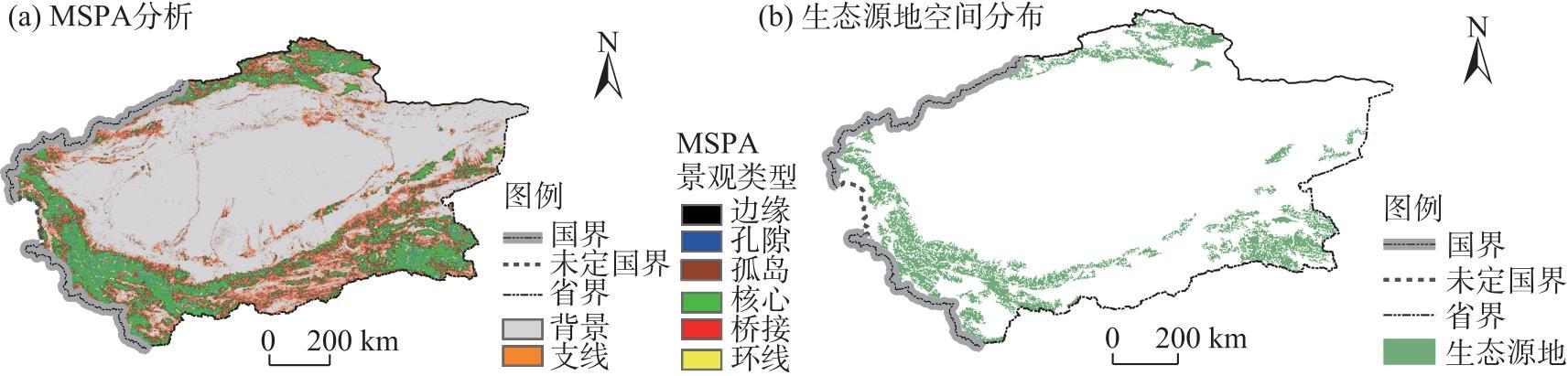
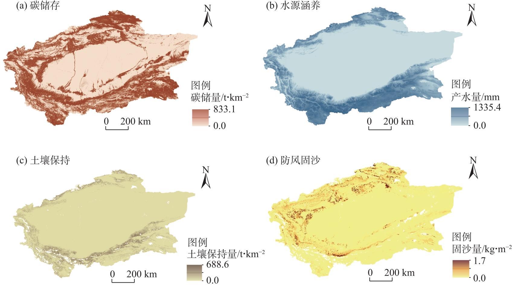
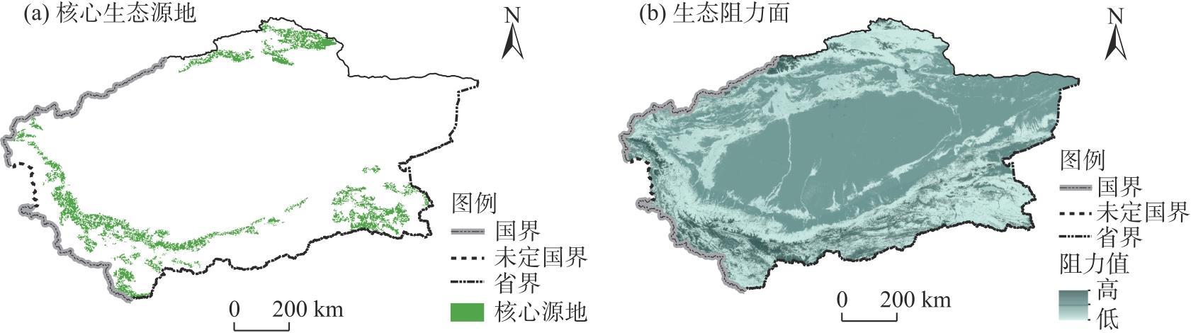
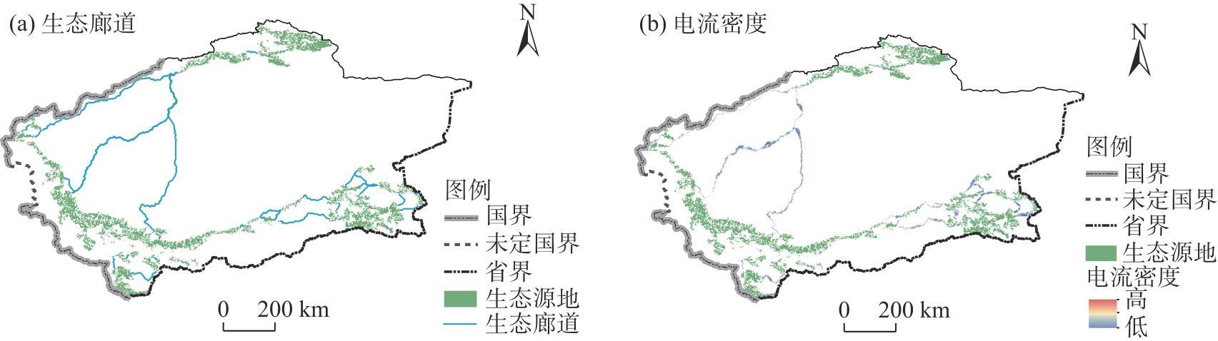
Ecological security plays an essential role in protecting biodiversity and maintaining ecosystem services. However, current research on the construction of ecological security patterns has mostly focused on treating nature reserves as ecological sources while ignoring patches with potential ecological services and the impact of patch connectivity. Thus, an improved method of constructing ecological security patterns is proposed herein. In this study, the oasis area of the Tarim Basin Rim, south Xinjiang, China is taken as an example. Ecological source sites are optimized by coupling four ecosystem services, namely, carbon storage, water conservation, soil conservation, wind and sand control, and landscape connectivity. An integrated resistance surface is constructed and the ecological security pattern of the study area is determined using circuit theory. The results show the following. (1) The oasis area around the Tarim Basin was in a low-ecological-security zone, with water shortage and serious desertification in the region. (2) A total of 22 ecological sources with an area of 69622.24 km2 and 33 ecological corridors with a length of 4722.39 km were identified in the Tarim Basin Rim oasis area, with the sources scattered in the south and densely sited in the north and with poor connectivity between the sources in the south and north. (3) An optimal layout plan for the ecological security pattern of “two screens, one ring, and multiple areas” was formed, ecological function zones were clarified, and the regional ecological environment was improved. This study can provide a reference for territorial spatial planning.
Qiusong HUANG , Hao HE . Ecological security pattern of the oasis area around the Tarim Basin based on coupled ecosystem services and landscape connectivity[J]. Arid Land Geography, 2024 , 47(10) : 1745 -1754 . DOI: 10.12118/j.issn.1000-6060.2024.022
表1 数据来源Tab. 1 Research data of the study |
| 数据类型 | 年份 | 分辨率 | 数据来源 |
|---|---|---|---|
| 土地利用数据 | 2020 | 30 m | 地球大数据科学工程数据共享服务系统(https://data.casearth.cn/) |
| 夜间灯光数据 | 2020 | 500 m | 国家青藏高原科学数据中心(https://data.tpdc.ac.cn/) |
| 高程数据 | - | 90 m | 地理空间数据云(http://www.gscloud.cn) |
| 土壤数据 | 2009 | 1:1000000 | 国家冰川冻土沙漠科学数据中心(http://www.ncdc.ac.cn/) |
| 降水量 | 2020 | 1 km | 中国科学院资源与环境科学数据中心(https://www.resdc.cn) |
| 气温 | 2020 | 1 km | 中国科学院资源与环境科学数据中心(https://www.resdc.cn) |
| 蒸散量 | 2020 | 1 km | 中国科学院资源与环境科学数据中心(https://www.resdc.cn) |
| 风速 | 2020 | 1 km | 国家地球系统科学数据中心(http://www.geodata.cn/) |
| 归一化植被指数 | 2020 | 250 m | 美国地质调查局(https://lpdaac.usgs.gov/) |
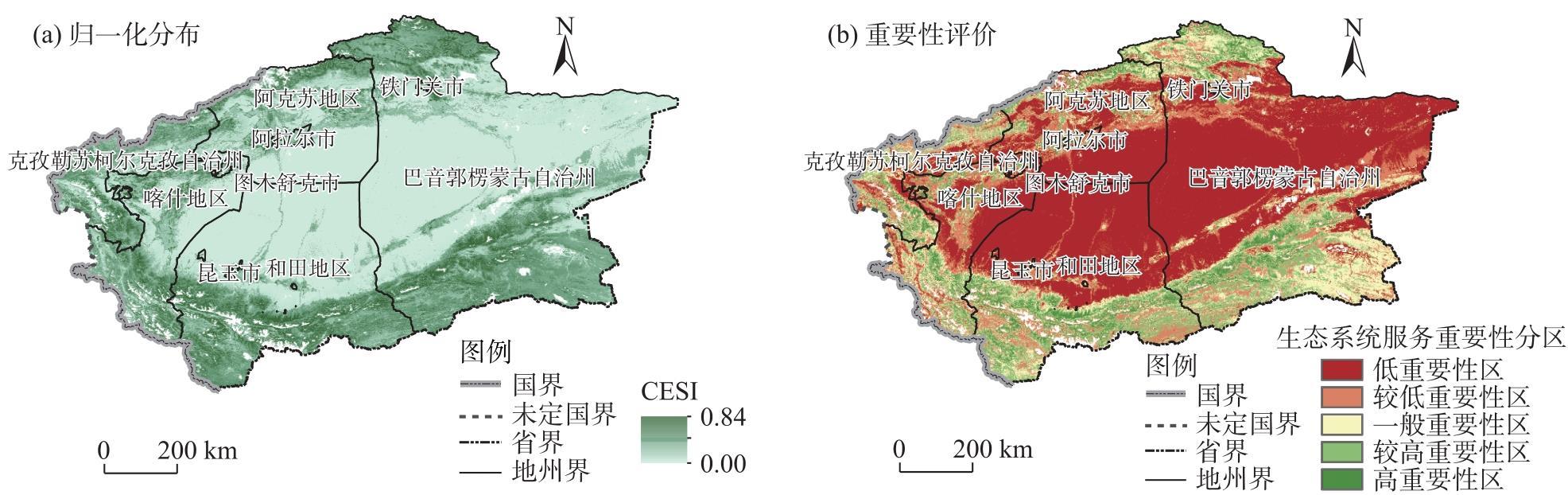
图4 生态系统服务综合指数空间分布注:CESI为生态系统服务综合指数。 Fig. 4 Spatial distribution of the composite index of ecosystem services |
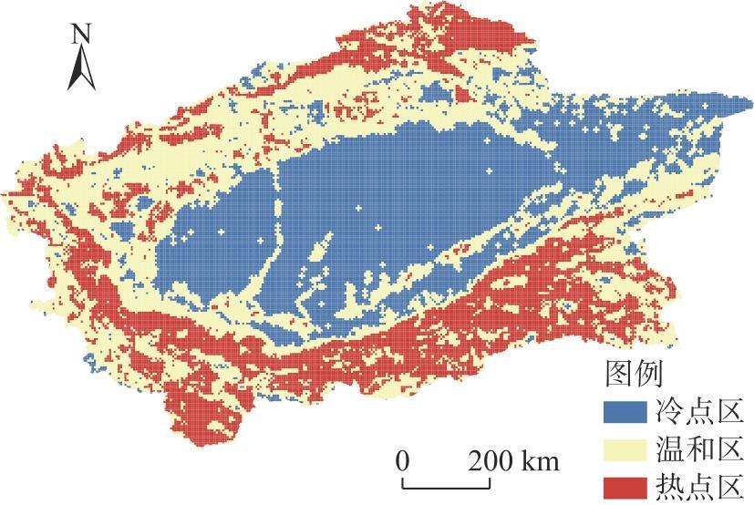
表2 生态系统服务重要性等级面积与比例Tab. 2 Area and proportion of ecosystem service importance level |
| 评价等级 | 面积/km2 | 比例/% |
|---|---|---|
| 高重要性区 | 52136.49 | 5.18 |
| 较高重要性区 | 120453.46 | 11.97 |
| 一般重要性区 | 155263.23 | 15.43 |
| 较低重要性区 | 160453.95 | 15.95 |
| 低重要性区 | 517745.11 | 51.47 |
| [1] |
彭建, 赵会娟, 刘焱序, 等. 区域生态安全格局构建研究进展与展望[J]. 地理研究, 2017, 36(3): 407-419.
[
|
| [2] |
|
| [3] |
|
| [4] |
|
| [5] |
|
| [6] |
|
| [7] |
彭建, 吕丹娜, 董建权, 等. 过程耦合与空间集成: 国土空间生态修复的景观生态学认知[J]. 自然资源学报, 2020, 35(1): 3-13.
[
|
| [8] |
田柳兰, 王珊珊, 毋兆鹏. 基于多时相遥感数据的乌鲁木齐市生态安全格局构建[J]. 干旱区地理, 2023, 46(7): 1155-1165.
[
|
| [9] |
|
| [10] |
|
| [11] |
|
| [12] |
|
| [13] |
|
| [14] |
|
| [15] |
|
| [16] |
|
| [17] |
|
| [18] |
|
| [19] |
|
| [20] |
|
| [21] |
|
| [22] |
|
| [23] |
|
| [24] |
|
| [25] |
|
| [26] |
|
| [27] |
柯新利, 唐兰萍. 城市扩张与耕地保护耦合对陆地生态系统碳储量的影响——以湖北省为例[J]. 生态学报, 2019, 39(2): 672-683.
[
|
| [28] |
|
| [29] |
邹雅婧, 闫庆武, 谭学玲, 等. 渭北矿区土壤侵蚀评估及驱动因素分析[J]. 干旱区地理, 2019, 42(6): 1387-1394.
[
|
| [30] |
蔺阿荣, 周冬梅, 马静, 等. 基于RWEQ模型的疏勒河流域防风固沙功能价值评估[J]. 干旱区地理, 2024, 47(1): 58-67.
[
|
| [31] |
张文静, 孙小银, 周俊. 南四湖流域关键生态系统服务的时空权衡关系[J]. 生态学报, 2021, 41(20): 8003-8015.
[
|
| [32] |
黄隆杨, 刘胜华, 方莹, 等. 基于“质量-风险-需求”框架的武汉市生态安全格局构建[J]. 应用生态学报, 2019, 30(2): 615-626.
[
|
| [33] |
|
| [34] |
|
| [35] |
|
| [36] |
|
/
| 〈 |
|
〉 |