
Ecological quality analysis of Ordos City based on the baseline remote sensing ecological index
Received date: 2023-04-13
Revised date: 2023-07-15
Online published: 2024-06-20
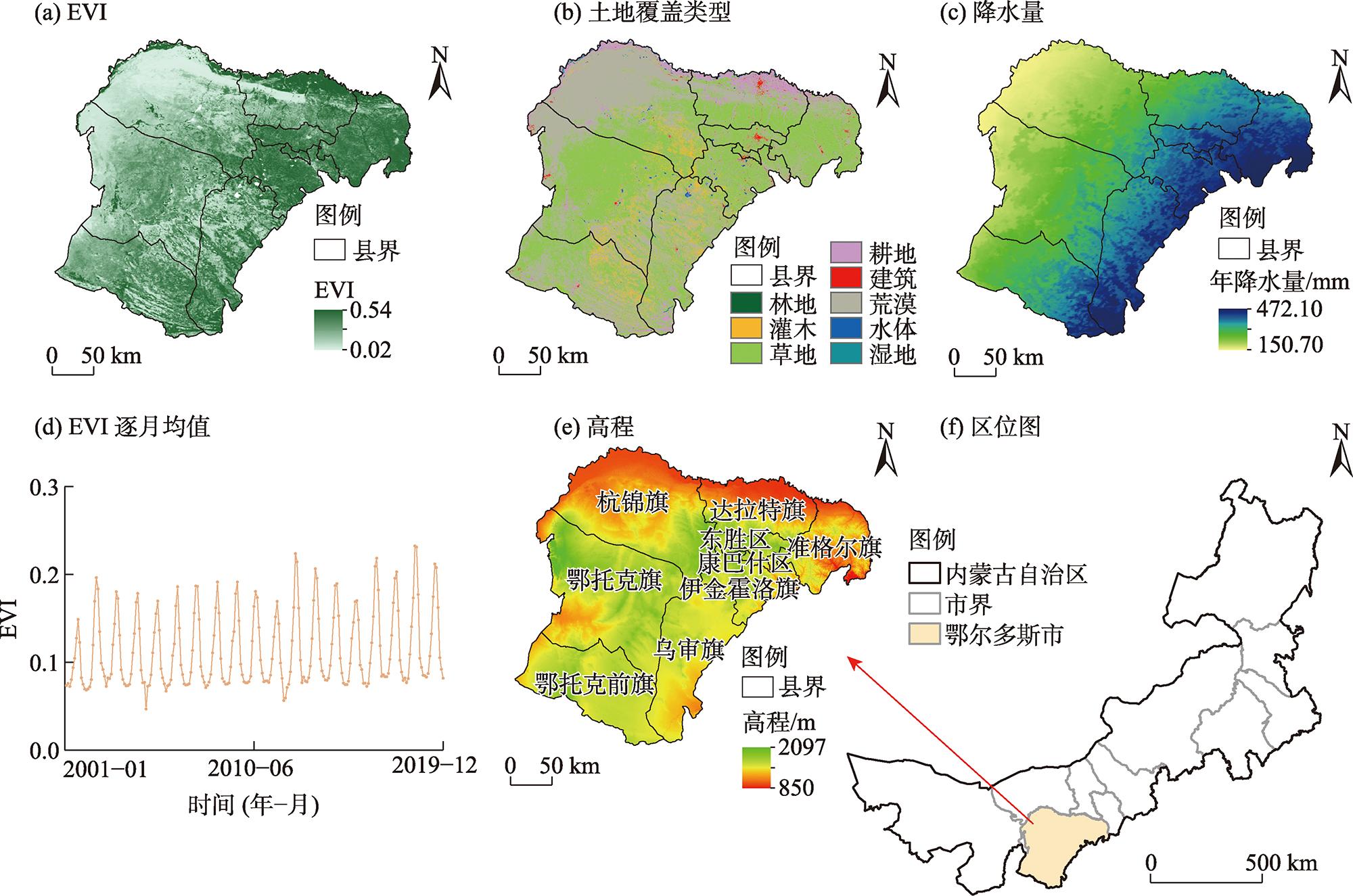
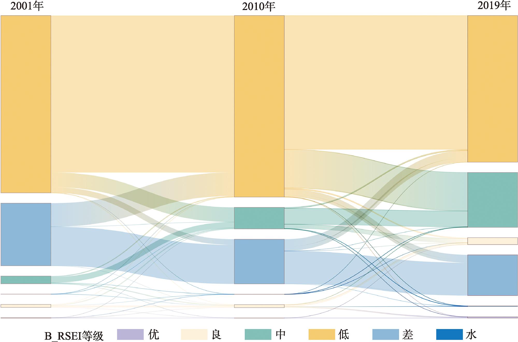
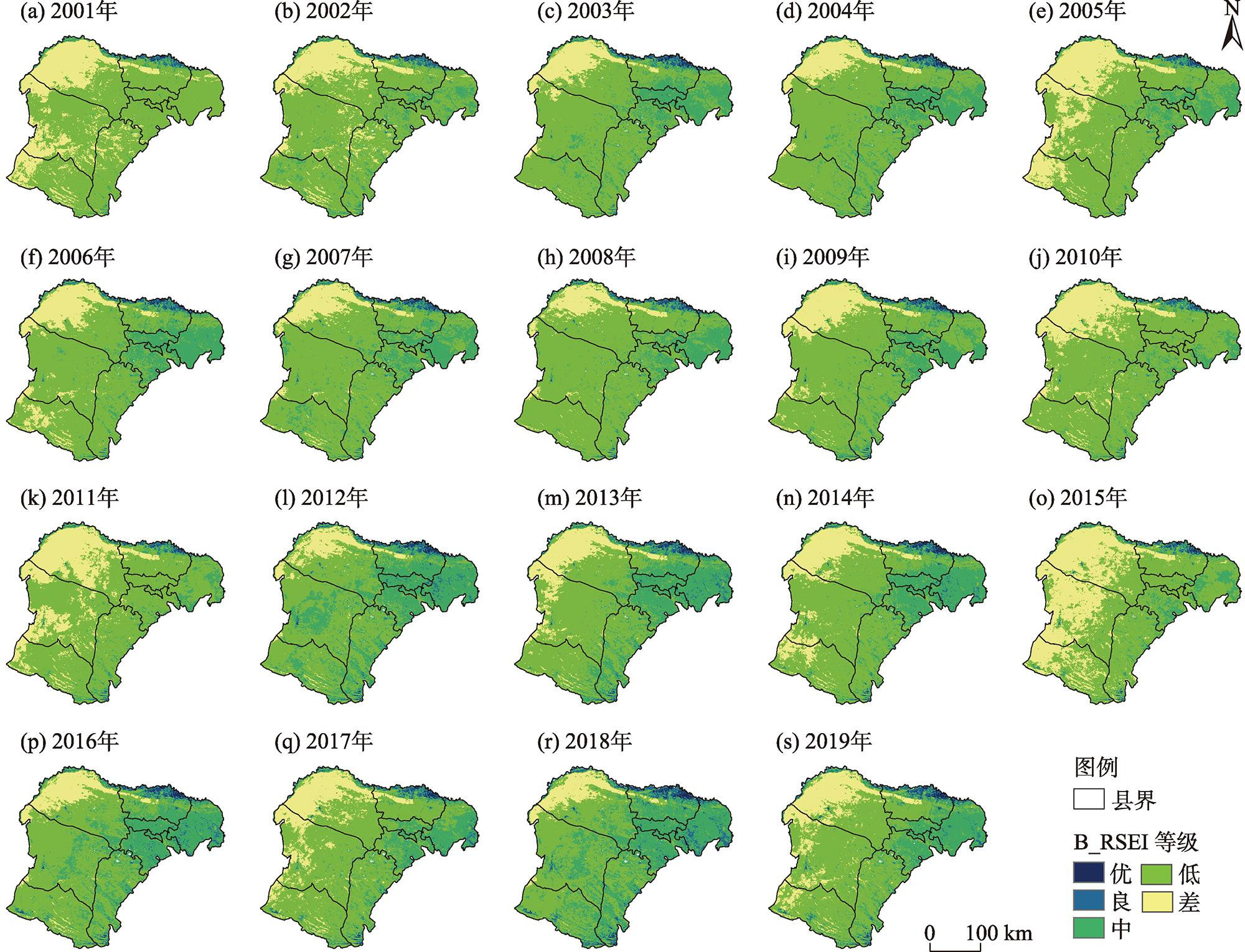
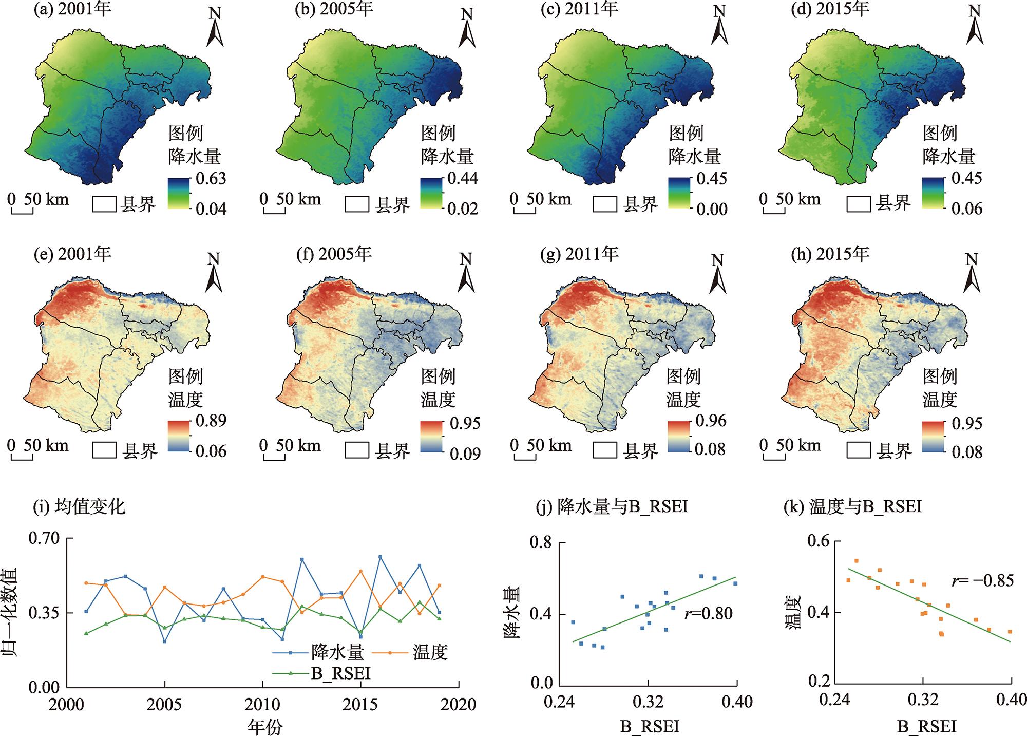
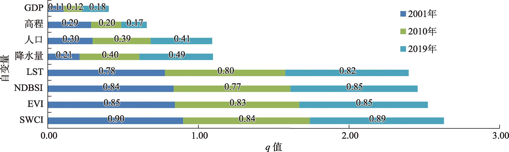
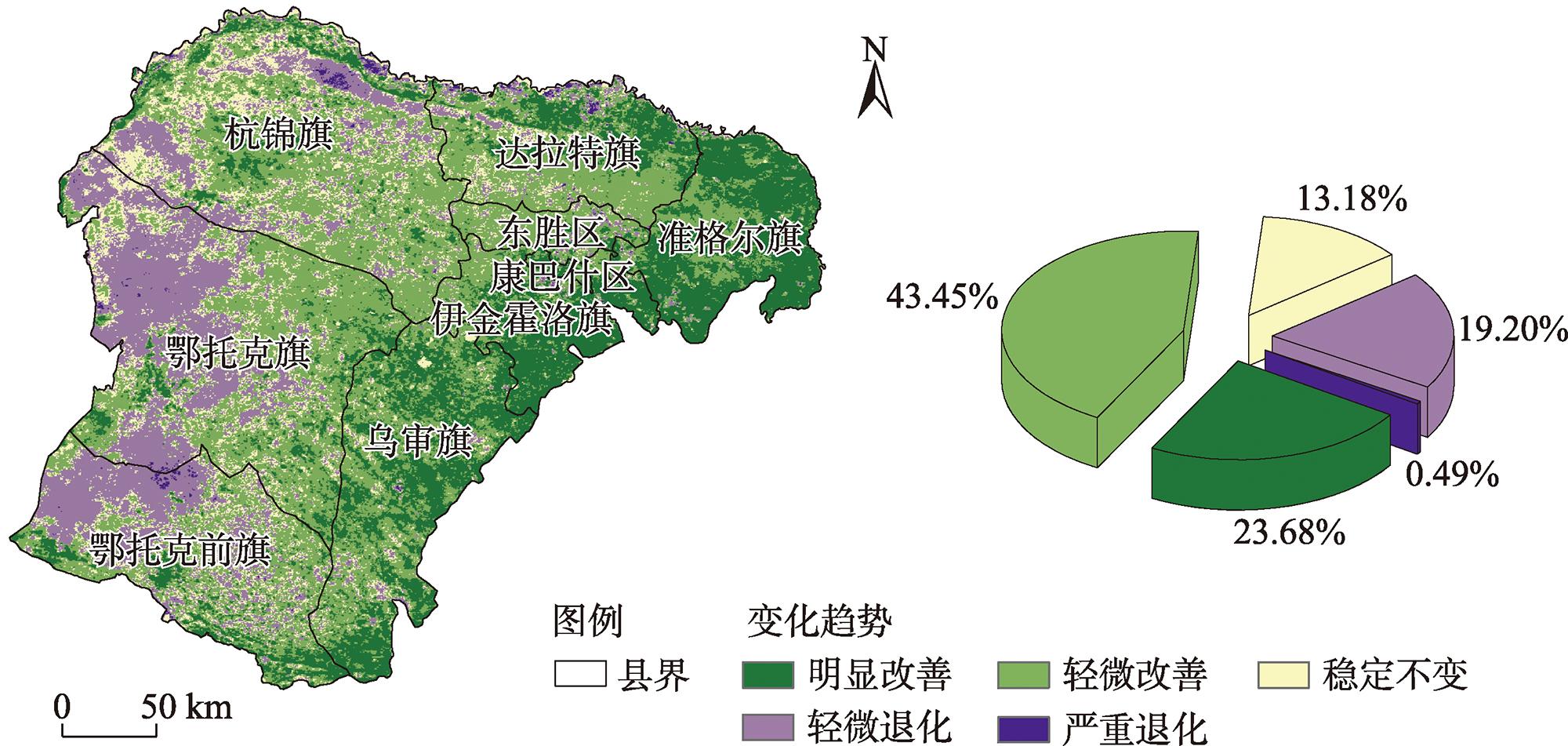
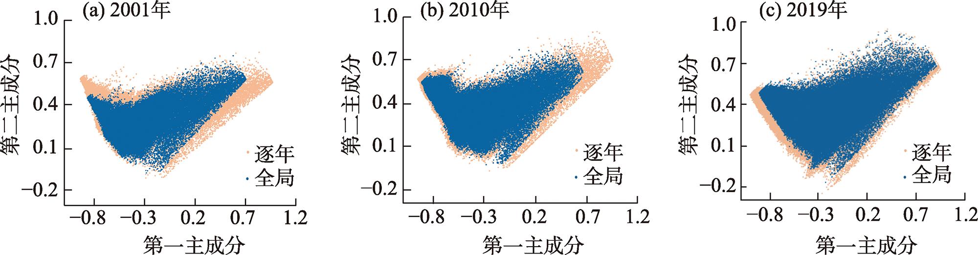
Ordos City is an important steppe desert and agropastoral ecotone in the Yellow River Basin, China. Studying the changes in ecological quality in Ordos City is important for supporting the ecological conservation and high-quality development of the Yellow River Basin. Herein, the remote sensing imagery of a moderate-resolution imaging spectroradiometer was used as a data source to calculate the baseline remote sensing ecological index (B_RSEI) of Ordos City by improving the conventional normalization and principal component analysis. This study also analyzes the characteristics of ecological quality changes from 2001 to 2019. The results indicate the following: (1) B_RSEI exhibits stable directionality and integrity, offering an enhanced reflection of long-term changes in ecological quality. From 2001 to 2019, B_RSEI of Ordos City showed a fluctuating increase and a spatial differentiation of higher in the east and lower in the west. (2) The surface water content index (SWCI) is the primary factor promoting B_RSEI and serves as the main factor explaining the B_RSEI distribution. The land surface temperature (LST) is the main factor inhibiting B_RSEI, with its most substantial interaction. (3) The ecological quality of Ordos City has improved, covering 67.13% of the total area, with notable ecological management effects in the Jungar Banner, Kangbashen District, and Ejin Horo Banner areas. This study demonstrates an overall improvement in the ecological quality of Ordos City, emphasizing the usefulness of B_RSEI in analyzing interannual changes. This could provide a reference for the ecological governance of the Ordos City and high-quality development of the Yellow River Basin.
Key words: ecological quality; B_RSEI; principal component analysis; Ordos City
Huazhu XUE , Qian YUAN , Guotao DONG , Nan YAO , Qing ZHANG . Ecological quality analysis of Ordos City based on the baseline remote sensing ecological index[J]. Arid Land Geography, 2024 , 47(2) : 248 -259 . DOI: 10.12118/j.issn.1000-6060.2023.162
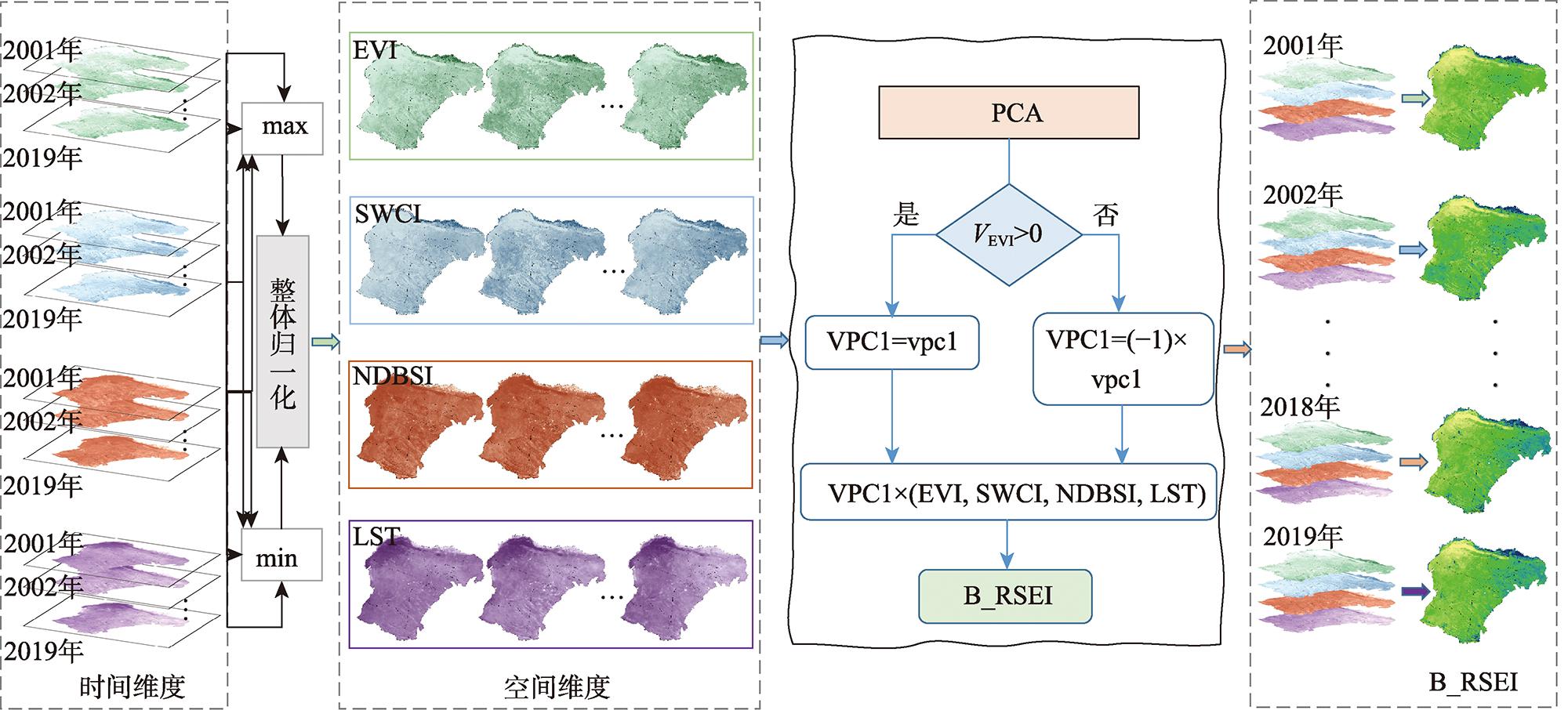
表1 指标主成分分析Tab. 1 Principal component analysis of four factors |
| 指标 | PC1 | PC2 | PC3 | PC4 |
|---|---|---|---|---|
| EVI | 0.47 | 0.40 | 0.44 | 0.65 |
| SWCI | 0.50 | 0.29 | 0.32 | -0.75 |
| NDBSI | -0.42 | -0.34 | 0.84 | -0.06 |
| LST | -0.59 | 0.80 | 0.02 | -0.07 |
| 特征值 | 0.0545 | 0.0099 | 0.0022 | 0.0013 |
| 贡献率/% | 80.35 | 14.53 | 3.22 | 1.90 |
注:PC1~PC4分别为第一、二、三、四主成分;EVI为绿度指标;SWCI为湿度指标;NDBSI为干度指标;LST为温度指标。下同。 |
图6 2001—2019年各因子对B_RSEI的解释力强度注:q为解释力强度。 Fig. 6 Explanatory power of each factor to B_RSEI from 2001 to 2019 |
表2 2001—2019年交互探测器分析结果Tab. 2 Analysis results of interactive detectors from 2001 to 2019 |
| 交互因子 | 2001年 | 2010年 | 2019年 | 交互因子 | 2001年 | 2010年 | 2019年 |
|---|---|---|---|---|---|---|---|
| SWCI∩EVI | 0.94 | 0.89 | 0.93 | NDBSI∩降水量 | 0.90 | 0.88 | 0.92 |
| SWCI∩NDBSI | 0.94 | 0.90 | 0.94 | NDBSI∩人口 | 0.87 | 0.82 | 0.87 |
| SWCI∩LST | 0.97 | 0.97 | 0.97 | NDBSI∩高程 | 0.88 | 0.87 | 0.88 |
| SWCI∩降水量 | 0.94 | 0.93 | 0.94 | NDBSI∩GDP | 0.85 | 0.78 | 0.85 |
| SWCI∩人口 | 0.91 | 0.88 | 0.91 | LST∩降水量 | 0.82 | 0.82 | 0.84 |
| SWCI∩高程 | 0.93 | 0.88 | 0.91 | LST∩人口 | 0.80 | 0.82 | 0.83 |
| SWCI∩GDP | 0.90 | 0.85 | 0.90 | LST∩高程 | 0.81 | 0.83 | 0.84 |
| EVI∩NDBSI | 0.92 | 0.92 | 0.92 | LST∩GDP | 0.79 | 0.81 | 0.83 |
| EVI∩LST | 0.97 | 0.97 | 0.98 | 降水量∩人口 | 0.52** | 0.58 | 0.62 |
| EVI∩降水量 | 0.88 | 0.89 | 0.91 | 降水量∩高程 | 0.54** | 0.60 | 0.63 |
| EVI∩人口 | 0.87 | 0.87 | 0.89 | 降水量∩GDP | 0.34** | 0.46 | 0.52 |
| EVI∩高程 | 0.88 | 0.86 | 0.88 | 人口∩高程 | 0.52 | 0.53 | 0.51 |
| EVI∩GDP | 0.86 | 0.85 | 0.88 | 人口∩GDP | 0.34 | 0.41 | 0.44 |
| NDBSI∩LST | 0.96 | 0.94 | 0.96 | 高程∩GDP | 0.37 | 0.31 | 0.30 |
注:GDP为国内生产总值;**表示非双线性增强。 |
| [1] |
张春桂, 李计英. 基于3S技术的区域生态环境质量监测研究[J]. 自然资源学报, 2010, 25(12): 2060-2071.
[
|
| [2] |
|
| [3] |
|
| [4] |
|
| [5] |
|
| [6] |
王小娜, 田金炎, 李小娟, 等. Google Earth Engine云平台对遥感发展的改变[J]. 遥感学报, 2022, 26(2): 299-309.
[
|
| [7] |
徐涵秋. 城市遥感生态指数的创建及其应用[J]. 生态学报, 2013, 33(24): 7853-7862.
[
|
| [8] |
|
| [9] |
|
| [10] |
王瑾杰, 丁建丽, 张子鹏. 基于遥感生态指数的吐哈地区生态环境变化研究[J]. 干旱区地理, 2022, 45(5): 1591-1603.
[
|
| [11] |
宋美杰, 罗艳云, 段利民. 基于改进遥感生态指数模型的锡林郭勒草原生态环境评价[J]. 干旱区研究, 2019, 36(6): 1521-1527.
[
|
| [12] |
罗镕基, 王宏涛, 王成. 基于改进遥感生态指数的甘肃省古浪县生态质量评价[J]. 干旱区地理, 2023, 46(4): 539-549.
[
|
| [13] |
|
| [14] |
|
| [15] |
|
| [16] |
|
| [17] |
马苏, 刘军会, 康玉麟, 等. 鄂尔多斯市防风固沙功能时空变化及驱动因素分析[J]. 环境科学研究, 2022, 35(11): 2477-2485.
[
|
| [18] |
黄金廷, 侯光才, 陶正平, 等. 鄂尔多斯高原植被生态分区及其水文地质意义[J]. 地质通报, 2008(8): 1330-1334.
[
|
| [19] |
|
| [20] |
|
| [21] |
谌稳, 孙立群, 李晴岚, 等. 一种基于图论重构MODIS EVI时间序列数据集的新方法[J]. 地球信息科学学报, 2022, 24(4): 738-749.
[
|
| [22] |
张红卫, 陈怀亮, 申双和, 等. 基于表层水分含量指数(SWCI)的土壤干旱遥感监测[J]. 遥感技术与应用, 2008, 23(6): 624-628, 600.
[
|
| [23] |
左璐, 孙雷刚, 鲁军景, 等. 基于MODIS的京津冀地区生态质量综合评价及其时空变化监测[J]. 自然资源遥感, 2022, 34(2): 203-214.
[
|
| [24] |
吕颖, 刘慧平, 刘锦绣. 基于中分辨率成像光谱仪数据的建筑指数研究[J]. 测绘科学, 2015, 40(5): 44-48, 70.
[
|
| [25] |
|
| [26] |
|
| [27] |
徐涵秋. 利用改进的归一化差异水体指数(MNDWI)提取水体信息的研究[J]. 遥感学报, 2005, 9(5): 589-595.
[
|
| [28] |
王劲峰, 徐成东. 地理探测器: 原理与展望[J]. 地理学报, 2017, 72(1): 116-134.
[
|
| [29] |
|
| [30] |
贺军奇, 魏燕, 高万德, 等. 毛乌素沙地东南缘植被NDVI时空变化及其对气候因子的响应[J]. 干旱区地理, 2022, 45(5): 1523-1533.
[
|
| [31] |
吴秦豫, 姚喜军, 梁洁, 等. 鄂尔多斯市煤矿区植被覆盖改善和退化效应的时空强度[J]. 干旱区资源与环境, 2022, 36(8): 101-109.
[
|
| [32] |
吕妍, 王让会, 蔡子颖. 我国干旱半干旱地区气候变化及其影响[J]. 干旱区资源与环境, 2009, 23(11): 65-71.
[
|
| [33] |
|
| [34] |
董天, 肖洋, 张路, 等. 鄂尔多斯市生态系统格局和质量变化及驱动力[J]. 生态学报, 2019, 39(2): 660-671.
[
|
| [35] |
马格. 鄂尔多斯市土地利用/覆被及植被覆盖度变化研究[D]. 呼和浩特: 内蒙古大学, 2020.
[
|
| [36] |
赵燕, 荆慧敏, 刘基智. 鄂尔多斯市黄河流域生态保护和高质量发展初步研究[J]. 北方经济, 2022(1): 60-64.
[
|
/
| 〈 |
|
〉 |