
Remote Sensing for Natural Resources >
InSAR-based monitoring and analysis of deformations induced by typical major geological hazards
Received date: 2024-10-11
Revised date: 2025-03-06
Online published: 2026-06-03
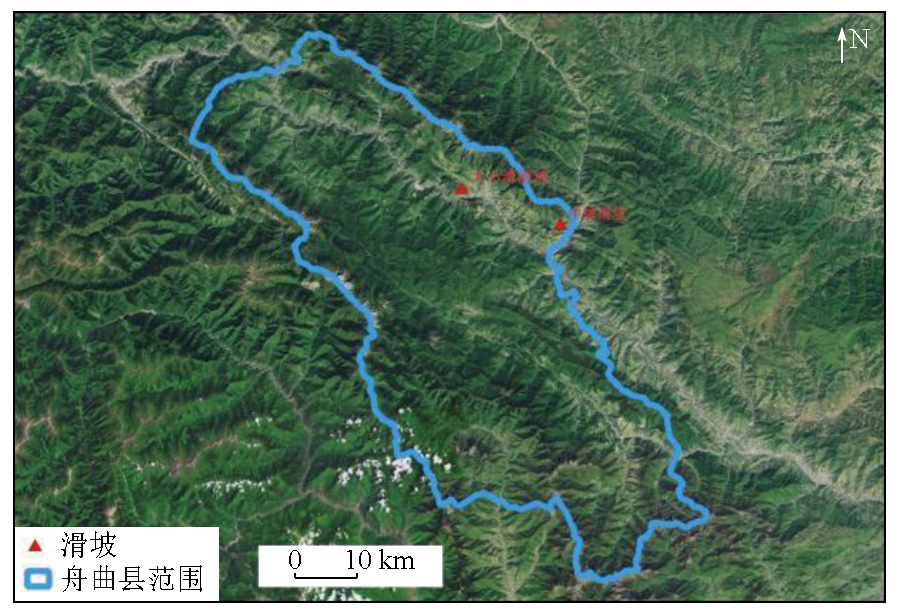
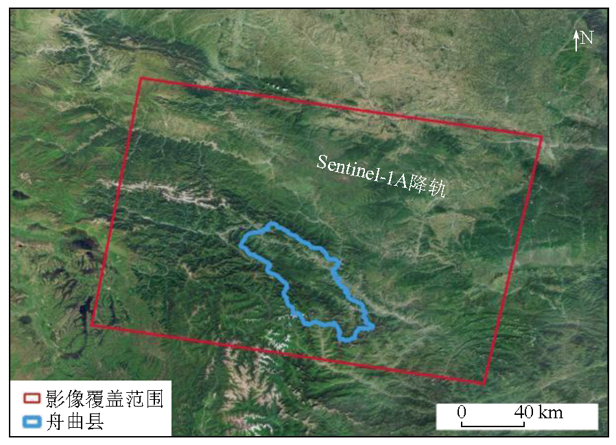
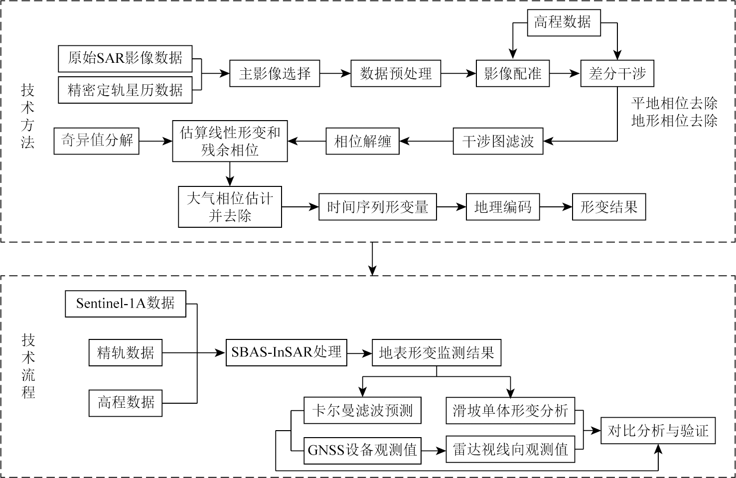
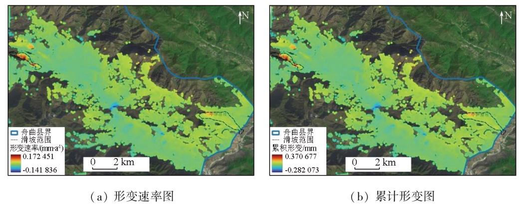
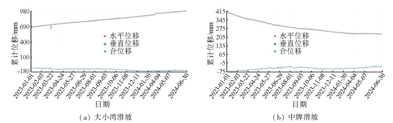
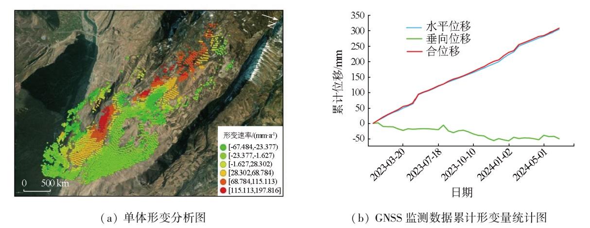
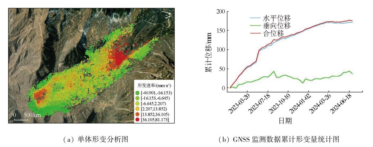
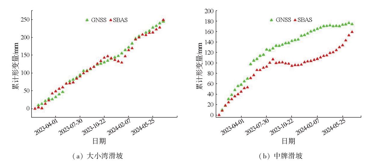
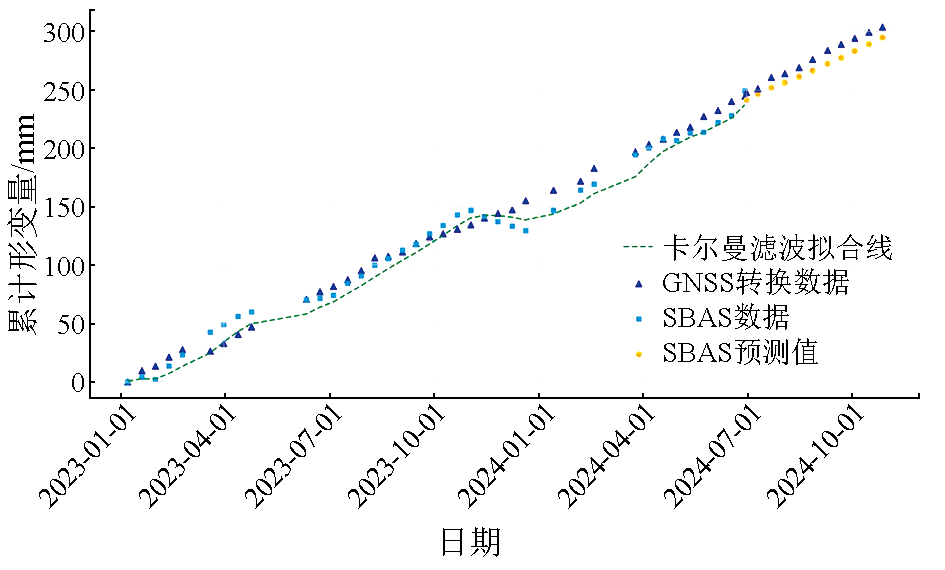
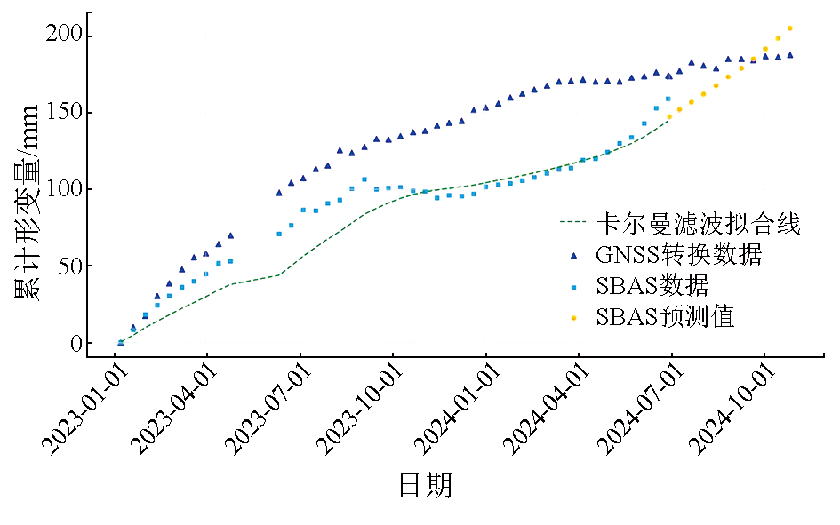
Given its all-day availability, all-weather adaptability, and high spatial resolution, the interferometric synthetic aperture radar (InSAR) technique has been widely applied in multiple fields, demonstrating strong adaptability and high practical value. Focusing on two typical landslide areas in Zhouqu County, Gansu Province, this study compared small baseline subset InSAR (SBAS-InSAR) monitoring results and Kalman filter prediction results with monitoring data from the global navigation satellite system (GNSS), confirming the reliability and accuracy of the SBAS-InSAR technique in monitoring landslide deformations. The results indicate that the SBAS-InSAR technique exhibited significant advantages in monitoring areas with deformations induced by geologic disasters, effectively overcoming the limitations of traditional monitoring means. This technique can provide critical technical support and scientific basis for early warning and management of geologic disasters in Zhouqu County and other areas prone to suffer these disasters.
SU Yunru , SHI Pengqing , ZHOU Xiaolong , ZHANG Juan . InSAR-based monitoring and analysis of deformations induced by typical major geological hazards[J]. Remote Sensing for Natural Resources, 2025 , 37(6) : 88 -96 . DOI: 10.6046/zrzyyg.2024329
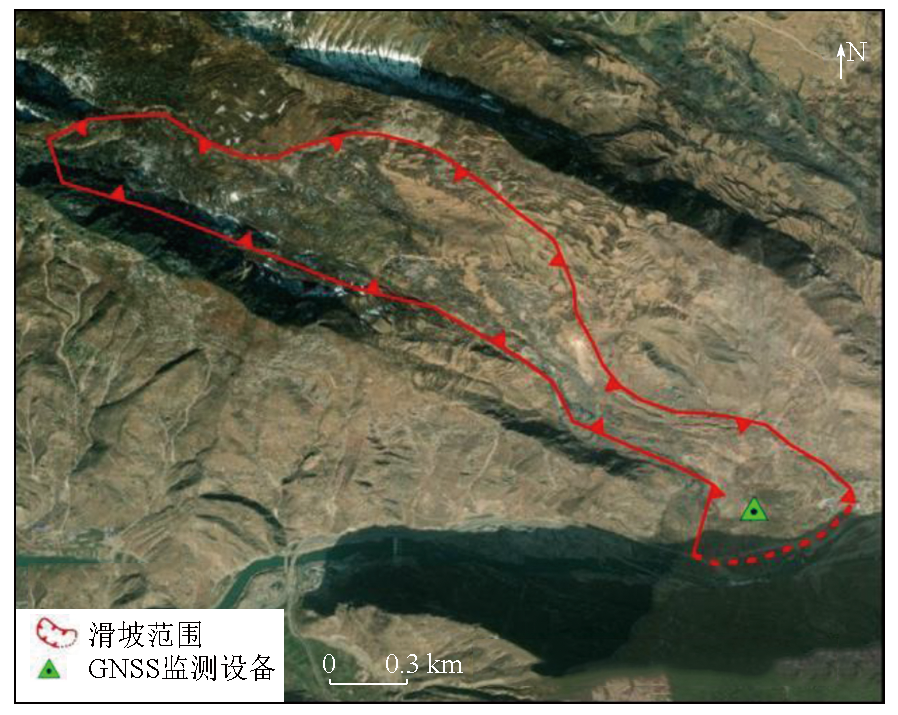
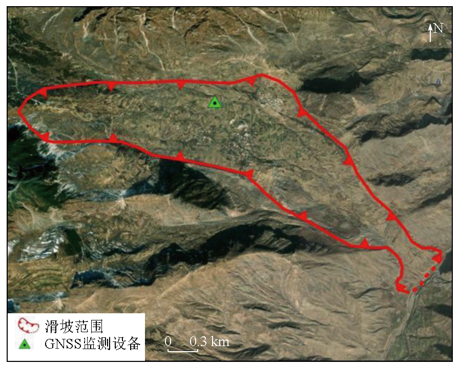
表2 GNSS设备信息Tab.2 Information on GNSS equipment |
| 滑坡 | 经度 | 纬度 | 安装时间 |
|---|---|---|---|
| 大小湾滑坡 | 104.339 402° E | 33.782 507° N | 2021年4月 |
| 中牌滑坡 | 104.417 715° E | 33.728 272° N | 2021年3月 |
| [1] |
许才军, 何平, 温扬茂, 等. InSAR技术及应用研究进展[J]. 测绘地理信息, 2015, 40(2):1-9.
|
| [2] |
刘国祥, 刘文熙, 黄丁发. InSAR技术及其应用中的若干问题[J]. 测绘通报, 2001(8):10-12.
|
| [3] |
刘一良. 微波遥感的发展与应用[J]. 沈阳工程学院学报(自然科学版), 2008, 4(2):171-173.
|
| [4] |
姜景山, 张云华, 董晓龙. 微波遥感若干前沿技术及新一代空间遥感方法探讨[J]. 中国工程科学, 2000, 2(8):76-82.
|
| [5] |
陈冉丽, 王红军, 刁鑫鹏, 等. InSAR形变监测在开采沉陷损害鉴定及稳定性评价中的应用[J]. 测绘通报, 2023(12):106-111.
|
| [6] |
|
| [7] |
刘菲, 陈蜜, 朱琳, 等. 采用升降轨Sentinel-1数据监测北京城市副中心地面沉降[J]. 地理信息世界, 2021, 28(6):44-52.
|
| [8] |
|
| [9] |
|
| [10] |
许才军, 林敦灵, 温扬茂. 利用InSAR数据的汶川地震形变场提取及分析[J]. 武汉大学学报(信息科学版), 2010, 35(10):1138-1142,1261-1262.
|
| [11] |
屈春燕, 张桂芳, 单新建, 等. 2010年青海玉树地震同震-震后形变场特征及演化过程[J]. 地球物理学报, 2013, 56(7):2280-2291.
|
| [12] |
刘振江, 韩炳权, 能懿菡, 等. InSAR观测约束下的2023年甘肃积石山地震震源参数及其滑动分布[J]. 武汉大学学报(信息科学版), 2025, 50(2):344-355.
|
| [13] |
|
| [14] |
代聪, 李为乐, 陆会燕, 等. 甘肃省舟曲县城周边活动滑坡InSAR探测[J]. 武汉大学学报(信息科学版), 2021, 46(7):994-1002.
|
| [15] |
丁宏伟. 甘肃省舟曲地质灾害发育特征及典型地质灾害剖析[J]. 甘肃地质, 2012, 21(1):47-53.
|
| [16] |
俞晶星, 郑文俊, 袁道阳, 等. 西秦岭西段光盖山-迭山断裂带坪定-化马断裂的新活动性与滑动速率[J]. 第四纪研究, 2012, 32(5):957-967.
|
| [17] |
李媛茜, 张毅, 孟兴民, 等. 活动构造断裂带巨型滑坡活动特性研究——以白龙江流域大小湾滑坡为例[J]. 兰州大学学报(自然科学版), 2021, 57(3):360-368.
|
| [18] |
杨为民, 黄晓, 张春山, 等. 白龙江流域坪定—化马断裂带滑坡特征及其形成演化[J]. 吉林大学学报(地球科学版), 2014, 44(2):574-583.
|
| [19] |
杨为民, 黄晓, 张永双, 等. 甘肃南部坪定-化马断裂带滑坡变形特征及其防治[J]. 地质通报, 2013, 32(12):1925-1935.
|
| [20] |
刘斌, 张丽, 李曼, 等. 融合CR和GNSS的InSAR滑坡形变时序监测方法和存储介质:中国,CN117761716A[P].2024-03-26.
|
| [21] |
|
| [22] |
周小龙, 石鹏卿. 基于SBAS-InSAR技术的甘肃华亭市地表形变监测与分析[J]. 测绘与空间地理信息, 2023, 46(2):30-33,38.
|
| [23] |
姜德才, 郑向向, 王宁, 等. 时序InSAR技术在珠三角地区地质灾害隐患识别中的应用[J]. 自然资源遥感, 2023, 35(3):292-301.doi:10.6046/zrzyyg.2022190.
|
| [24] |
|
/
| 〈 |
|
〉 |