
Remote Sensing for Natural Resources >
Analyzing water area changes and inundation trends in Siling Co during 1995—2023 based on multi-source remote sensing
Received date: 2024-10-09
Revised date: 2025-02-14
Online published: 2026-06-03
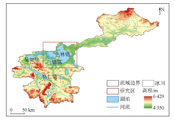
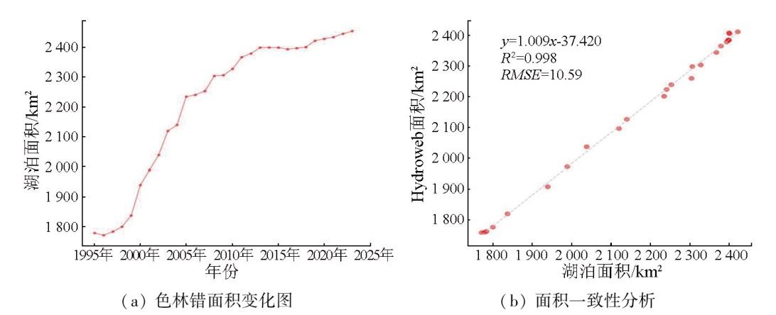
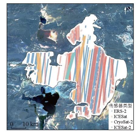
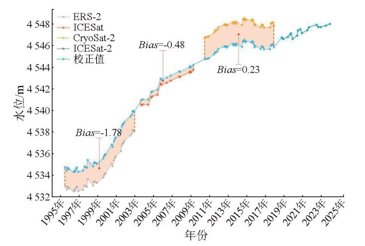
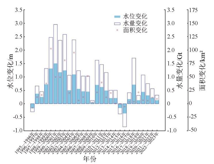
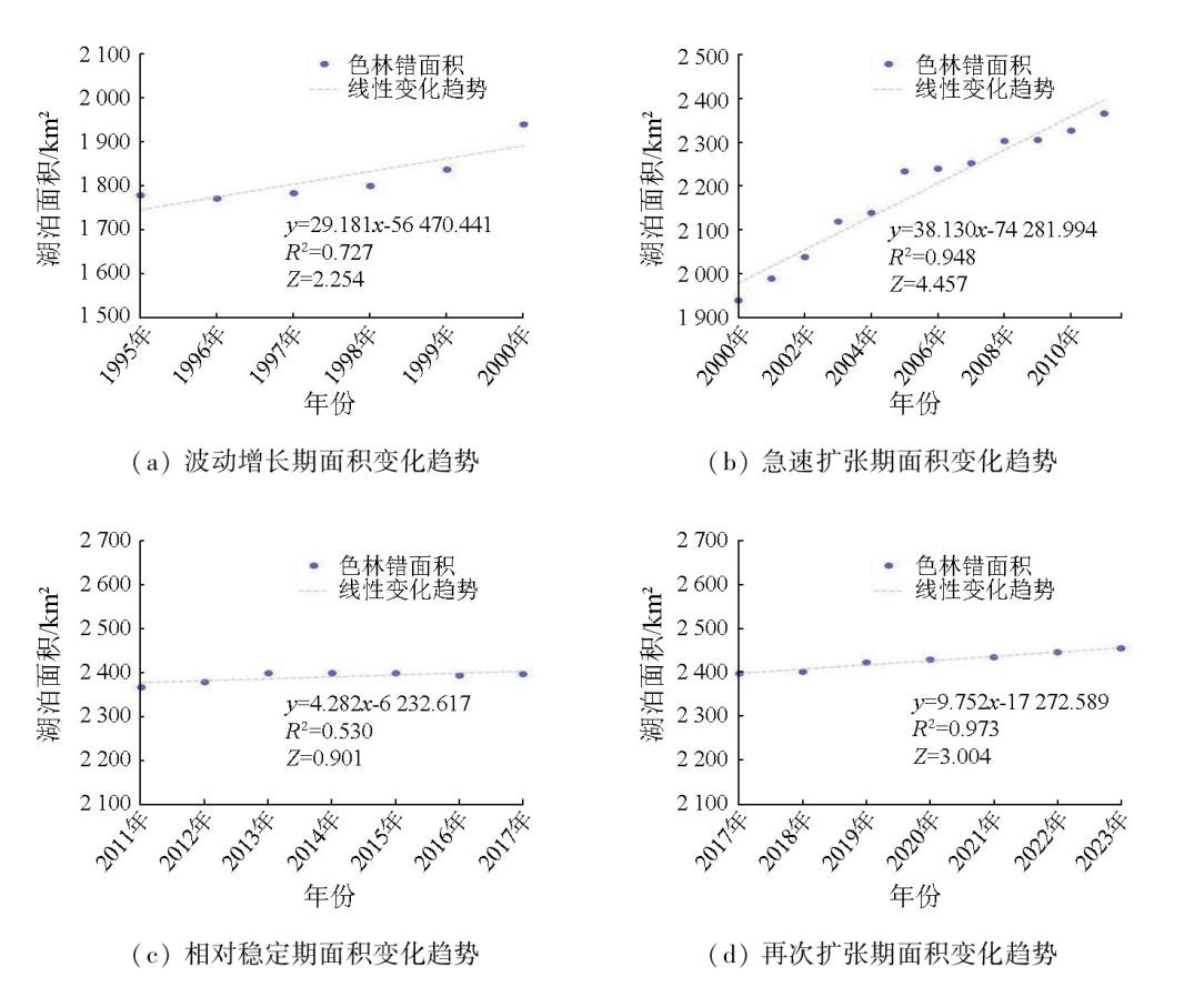
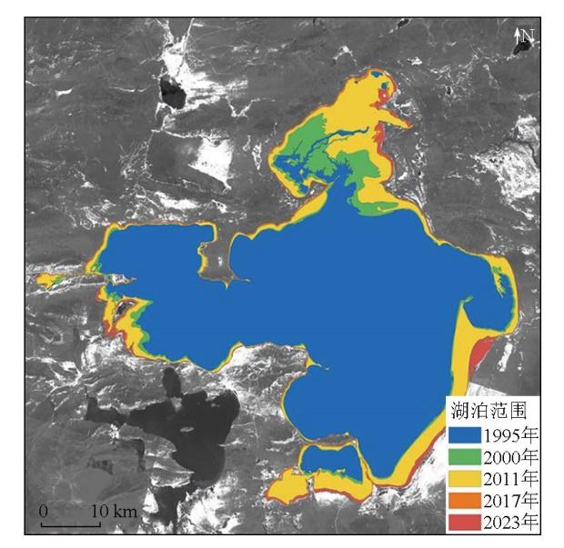
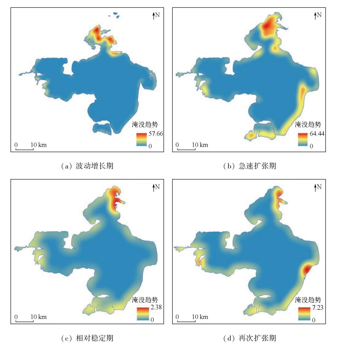
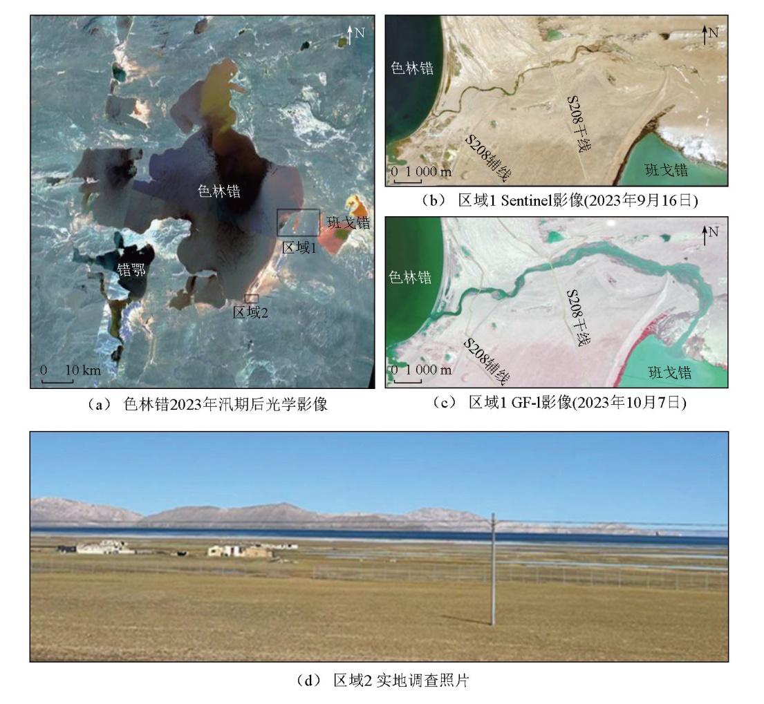
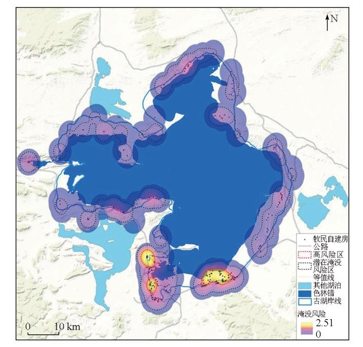
Siling Co, the largest lake in Xizang Autonomous Region, has expanded significantly in the past few years, threatening surrounding pastoral activities, infrastructures, and even the ecological environment. This study systematically reconstructed the time series of changes in the lake area, water level, and water volume of Siling Co from 1995 to 2023 using optical images from satellites Landsat and GF, as well as altimeter data from satellites ERS-2, ICEsat, Cryosat-2, and ICEsat-2. Through Mann-Kendall trend analysis, the study determined the stages of the lake area changes and revealed the key characteristics of various stages. Furthermore, it also made a preliminary judgement on the inundation trend and its impacts. The results indicate that from 1995 to 2023, Siling Co experienced an increase in water area of 676.75 km2 (with an annual average of 24.17 km2/a), a water level rise of approximately 13.32 m (with an annual average of 0.48 m/a), and a water volume growth of 28.45 Gt (with an annual average of 1.02 Gt/a). The changes in Siling Co from 1995 to 2023 can be divided into four stages: the fluctuating growth stage from 1995 to 2000, the rapid expansion stage from 2000 to 2011, the relatively stable stage from 2011 to 2017, and the re-expansion stage from 2017 to 2023. The inundated areas during the fluctuating growth and rapid expansion stages were primarily concentrated in the northern and southern parts of the lake. During the relatively stable stage, no significant expansion was observed in the inundated areas. In the re-expansion stage, the inundated areas were distributed in the eastern part of the lake. The continuous rise in the water level of Siling Co led to an annually increasing risk of surrounding inundation. Currently, the areas exposed to a high inundation risk are primarily concentrated along the south bank of the lake, which should be the focus in future monitoring and research.
Key words: remote sensing (RS); Siling Co; satellite altimetry; lake level; inundation risk
WANG Haochen , HE Peng , CHEN Hong , TONG Liqiang , GUO Zhaocheng , TU Jienan , WANG Genhou . Analyzing water area changes and inundation trends in Siling Co during 1995—2023 based on multi-source remote sensing[J]. Remote Sensing for Natural Resources, 2025 , 37(6) : 251 -262 . DOI: 10.6046/zrzyyg.2024339
表1 光学遥感卫星详情Tab.1 Optical image details |
| 数据年份 | 传感器类型 | 空间分辨率/m | 数据格式 |
|---|---|---|---|
| 1995—2012年 | Landsat TM/ETM+ | 30 | GeoTIFF |
| 2013—2023年 | GF-1 WFV | 16 | GeoTIFF |
表2 卫星基本参数Tab.2 Satellite basic parameters |
| 测高卫星 | 传感器 | 工作年份 | 周期/d | 足迹间距/m | 精度/cm |
|---|---|---|---|---|---|
| ERS-2 | RA | 1995—2011年 | 35 | 约300 | 约10 |
| ICESat | GLAS | 2003—2009年 | 91 | 约170 | 约10 |
| CryoSat-2 | SIRAL | 2010年至今 | 369 | 约300 | 1~3 |
| ICESat-2 | ATLAS | 2018年至今 | 91 | 约0.7 | 约3 |
h=Htp-M-0.7,
表3 色林错1995—2023年平均水位变化Tab.3 Water level changes of Siling Co from 1995 to 2023 |
| 年份 | 传感器类型 | 统计月数/月 | 平均水位/m |
|---|---|---|---|
| 1995年 | ERS-2 | 5 | 4 534.63 |
| 1996年 | 6 | 4 534.46 | |
| 1997年 | 5 | 4 534.83 | |
| 1998年 | 5 | 4 535.08 | |
| 1999年 | 4 | 4 535.80 | |
| 2000年 | 5 | 4 537.11 | |
| 2001年 | 5 | 4 538.60 | |
| 2002年 | 5 | 4 539.77 | |
| 2003年 | ICESat | 2 | 4 541.01 |
| 2004年 | 3 | 4 541.51 | |
| 2005年 | 3 | 4 542.60 | |
| 2006年 | 2 | 4 543.15 | |
| 2007年 | 2 | 4 543.61 | |
| 2008年 | 2 | 4 544.06 | |
| 2009年 | 2 | 4 544.11 | |
| 2010年 | CryoSat-2 | 4 | 4 544.81 |
| 2011年 | 5 | 4 545.43 | |
| 2012年 | 5 | 4 545.92 | |
| 2013年 | 6 | 4 546.13 | |
| 2014年 | 6 | 4 546.34 | |
| 2015年 | 6 | 4 546.18 | |
| 2016年 | 5 | 4 545.82 | |
| 2017年 | 6 | 4 545.99 | |
| 2018年 | ICESat-2 | 3 | 4 546.70 |
| 2019年 | 4 | 4 546.82 | |
| 2020年 | 4 | 4 547.27 | |
| 2021年 | 2 | 4 547.58 | |
| 2022年 | 3 | 4 547.81 | |
| 2023年 | 2 | 4 547.95 |
表4 色林错1995—2023年间水量变化Tab.4 Water storage changes of Siling Co from 1995 to 2023 |
| 年份 | 水量/Gt | 年份 | 水量/Gt | 年份 | 水量/Gt |
|---|---|---|---|---|---|
| 1995—1996年 | -0.30 | 2005—2006年 | 1.23 | 2015—2016年 | -0.86 |
| 1996—1997年 | 0.66 | 2006—2007年 | 1.03 | 2016—2017年 | 0.41 |
| 1997—1998年 | 0.45 | 2007—2008年 | 1.03 | 2017—2018年 | 1.70 |
| 1998—1999年 | 1.31 | 2008—2009年 | 0.12 | 2018—2019年 | 0.31 |
| 1999—2000年 | 2.47 | 2009—2010年 | 1.62 | 2019—2020年 | 1.07 |
| 2000—2001年 | 2.95 | 2010—2011年 | 1.46 | 2020—2021年 | 0.75 |
| 2001—2002年 | 2.36 | 2011—2012年 | 1.16 | 2021—2022年 | 0.56 |
| 2002—2003年 | 2.58 | 2012—2013年 | 0.50 | 2022—2023年 | 0.32 |
| 2003—2004年 | 1.06 | 2013—2014年 | 0.50 | 1995—2023年 | 28.45 |
| 2004—2005年 | 2.38 | 2014—2015年 | -0.38 |
表5 各阶段色林错Mann-Kendall趋势检验Tab.5 The Mann-Kendal trend test for each stage of Siling Co |
| 年份 | 时期 | R2 | Z | P |
|---|---|---|---|---|
| 1995—2000年 | 波动增长期 | 0.73 | 2.254 | 0.01 < P <0.05 |
| 2000—2011年 | 急速扩张期 | 0.95 | 4.457 | P < 0.001 |
| 2011—2017年 | 相对稳定期 | 0.53 | 0.901 | P > 0.05 |
| 2017—2023年 | 再次扩张期 | 0.97 | 3.004 | P < 0.01 |
| [1] |
王坤鑫, 张寅生, 张腾, 等. 1979—2017年青藏高原色林错流域气候变化分析[J]. 干旱区研究, 2020, 37(3):652-662.
|
| [2] |
张国庆. 青藏高原湖泊变化遥感监测及其对气候变化的响应研究进展[J]. 地理科学进展, 2018, 37(2):214-223.
|
| [3] |
|
| [4] |
张国庆, 王蒙蒙, 周陶, 等. 青藏高原湖泊面积、水位与水量变化遥感监测研究进展[J]. 遥感学报, 2022, 26(1):115-125.
|
| [5] |
马耀明, 胡泽勇, 田立德, 等. 青藏高原气候系统变化及其对东亚区域的影响与机制研究进展[J]. 地球科学进展, 2014, 29(2):207-215.
|
| [6] |
|
| [7] |
|
| [8] |
|
| [9] |
|
| [10] |
|
| [11] |
|
| [12] |
宋玉芝, 德吉玉珍. 近30年色林错湖面变化特征及其对气候变化的响应[J]. 南京信息工程大学学报(自然科学版), 2023, 15(1):24-33.
|
| [13] |
杨志刚, 杜军, 林志强. 1961—2012年西藏色林错流域极端气温事件变化趋势[J]. 生态学报, 2015, 35(3):613-621.
|
| [14] |
|
| [15] |
刘建康, 张佳佳, 高波, 等. 我国西藏地区冰湖溃决灾害综述[J]. 冰川冻土, 2019, 41(6):1335-1347.
|
| [16] |
贾洋, 崔鹏. 西藏冰湖溃决灾害事件极端气候特征[J]. 气候变化研究进展, 2020, 16(4):395-404.
|
| [17] |
|
| [18] |
|
| [19] |
|
| [20] |
德吉央宗, 尼玛吉, 强巴欧珠, 等. 近40年西藏色林错流域湖泊面积变化及影响因素分析[J]. 高原山地气象研究, 2018, 38(2):35-41,96.
|
| [21] |
邰雪楠, 王宁练, 吴玉伟, 等. 近20 a色林错湖冰物候变化特征及其影响因素[J]. 湖泊科学, 2022, 34(1):334-348.
|
| [22] |
|
| [23] |
李振南, 雷伟伟, 王一帆, 等. 基于多源卫星测高数据的青海湖水位变化研究[J]. 测绘科学, 2023, 48(5):140-151.
|
| [24] |
武文娇, 章诗芳, 苏巧梅, 等. 黄土高原重要水库水位变化的ICESat/GLA14监测[J]. 测绘科学, 2018, 43(4):71-75.
|
| [25] |
|
| [26] |
|
| [27] |
|
| [28] |
|
| [29] |
|
| [30] |
|
| [31] |
孟恺, 石许华, 王二七, 等. 青藏高原中部色林错区域古湖滨线地貌特征、空间分布及高原湖泊演化[C]// 中国科学院地质与地球物理研究所2012年度(第12届)学术论文汇编——特提斯研究中心. 北京, 2013:618-633.
|
| [32] |
|
/
| 〈 |
|
〉 |