
Remote Sensing for Natural Resources >
A comparative study of the methods for delineating wildland-urban interfaces: A case study of Wood Buffalo, Alberta, Canada
Received date: 2024-10-18
Revised date: 2025-02-17
Online published: 2026-06-03
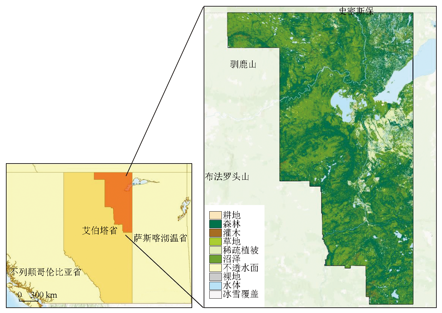
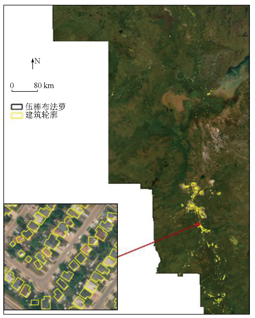
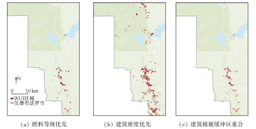
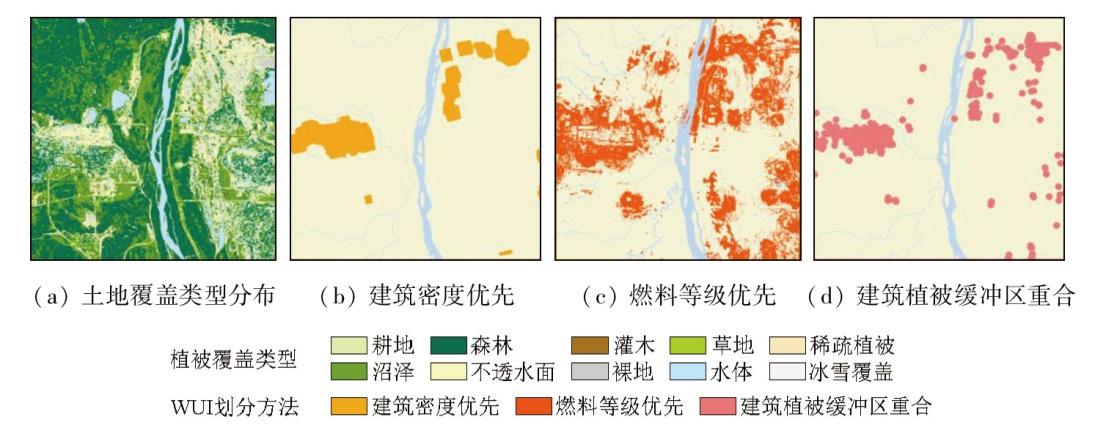
A wildland-urban interface (WUI) refers to the area where residential buildings meet or intermingle with natural vegetation such as forests. The delineation of the WUI plays an important role in fire risk management, forest resource development and utilization, climate change responses, and sustainable socio-economic development. Current methods for WUI delineation are primarily developed and refined based on the definition given in the Federal Register of the United States. Based on indicators such as building density, vegetation coverage, and the distance between buildings and vegetation, these methods can be categorized into three types: building density priority, fuel grade priority, and overlap between building-vegetation buffer zones. Initially, this study presented a summary and comparison of relevant literature on the three types of methods. Then, Wood Buffalo in Alberta, Canada, an area frequently affected by wildfires, was selected to compare the three methods using data on Canadian building footprints released by Microsoft, global land cover from GLC_FCS30-2020, and local historical fire points and fire scars. The results indicate that the building density priority method exhibited the highest coincidence rate with historical wildfire records. However, it overlooked low-density buildings that were also at risk of wildfire. The fuel grade priority method produced a larger delineation area, with a lower coincidence rate with historical wildfire records since it focused excessively on the vegetation around buildings while neglecting the buildings themselves. In contrast, overlap between building-vegetation buffer zones presented the lowest coincidence rate with historical wildfire records and the smallest delineation area. This occurred primarily due to the short distance setting of buffer zones. This study reveals the strengths and limitations of existing methods, contributing to more scientifically robust and rational WUI delineation in the future while also providing references for decision-making in fire risk management and emergency responses.
WANG Zimeng , LIAO Yuanhong , LOU Shuhan , BAI Yuqi . A comparative study of the methods for delineating wildland-urban interfaces: A case study of Wood Buffalo, Alberta, Canada[J]. Remote Sensing for Natural Resources, 2025 , 37(6) : 211 -218 . DOI: 10.6046/zrzyyg.2024336
表1 部分WUI划分方法汇总表Tab.1 Summary table of some forest-town interface division methods |
| 作者 | WUI子类 | 筛选要素及阈值 | 所用数据 | 年份 | 研究区 |
|---|---|---|---|---|---|
| Schug等 [11] | 交界WUI 和混合 WUI | 利用500 m半径圆形移动窗口计算建筑密度和植被覆盖率 住房密度大于每16.19 hm21栋房屋,并且野生植被覆盖率超过50%或低于50%但位于大型密集植被区域的2.4 km范围内 | 土地覆盖数据 建筑面积占比数据 | 2023年 | 全球 |
| Chen等[12] | 交界WUI 和混合 WUI | 建立400 m网格计算建筑密度和植被覆盖率 住房密度大于每16.19 hm21栋房屋,并且野生植被覆盖率超过50%或低于50%但位于大型密集植被区域的2.4 km范围内 | 土地覆盖数据 人口密度数据 建筑足迹数据 | 2024年 | 全球 |
| Carlson等[10] | 交界WUI 和混合 WUI | 根据不同的邻域半径大小,确定划分WUI的范围,论文中选择了100 m,200 m,300 m,400 m,500 m和1 500 m 住房密度大于每16.19 hm21栋房屋,并且野生植被覆盖率超过50%或低于50%但位于大型密集植被区域的2.4 km范围内 | 建筑足迹数据 土地覆盖数据 | 2022年 | 美国 |
| Johnston等[13] | 住房WUI、工业WUI 和公共设施WUI | 根据植被的可燃性和连通性算植被的权重燃料等级 根据不同的权重燃料等级创建可变宽度缓冲区域 冲区的最大宽度为2 400 m,燃料等级越高,燃烧成本越高,缓冲区越小 | 建筑足迹数据 土地覆盖数据 | 2018年 | 加拿大 |
| Bar-Massada等[14] | 交界WUI 和混合 WUI | 建成区缓冲区100 m内的像元作为候选像元 候选像元500 m半径内植被密度>50% 候选像元距离大型植被斑块<600 m | 建筑足迹数据 土地覆盖数据 | 2023年 | 欧盟 |
| Modugno等[15] | — | 距离建筑区域<200 m 距离野生植被区域<400 m | 建筑位置数据 土地覆盖数据 | 2016年 | 欧盟 |
表2 不同土地覆盖类型 (GLC-FCS30—2020)的燃料等级相对排名Tab.2 Relative ranking of fuel levels for different land cover types (GLC-FCS30—2020) |
| 栅格值 | 种类 | 燃料等级 |
|---|---|---|
| 71 | 开阔常绿针叶林(0.15<fc①<0.4) | 1 |
| 72 | 闭阔常绿针叶林(fc>0.4) | 1 |
| 81 | 开阔落叶针叶林(0.15<fc<0.4) | 1 |
| 82 | 闭阔落叶针叶林(fc>0.4) | 1 |
| 51 | 开阔常绿阔叶林 | 2 |
| 52 | 闭阔常绿阔叶林 | 2 |
| 61 | 开阔落叶阔叶林(0.15<fc<0.4) | 2 |
| 62 | 闭阔落叶阔叶林(fc>0.4) | 2 |
| 91 | 开阔混交叶片林(阔叶树和针叶树) | 2 |
| 92 | 闭阔混交叶片林(阔叶树和针叶树) | 2 |
| 120 | 灌木地 | 3 |
| 121 | 常绿灌木地 | 3 |
| 122 | 落叶灌木地 | 3 |
| 130 | 草地 | 3 |
| 152 | 稀疏灌木地(fc<0.15) | 3 |
| 180 | 沼泽 | 4 |
| 150 | 稀疏植被(fc<0.15) | 4 |
| 153 | 稀疏草本植被(fc<0.15) | 5 |
| 11 | 草本植被覆盖 | 5 |
| 10 | 耕地 | / |
| 12 | 树木或灌木覆盖(果园) | / |
| 20 | 灌溉耕地 | / |
| 140 | 地衣和苔藓植被 | / |
| 190 | 不透水表面 | / |
| 200 | 裸地 | / |
| 201 | 固化裸地 | / |
| 202 | 非固化裸地 | / |
| 210 | 水体 | / |
| 220 | 永久性冰雪覆盖 | / |
| 250 | 填充值 | / |
①fc为覆盖分量(fractional cover) |
表3 伍德布法罗市不同城市森林交界域的建筑数量Tab.3 Statistical count of buildings at the different WUI of Wood Buffalo City (个) |
| 划分方法 | 建筑位置 | 对WUI建立的缓冲区距离/m | |||
|---|---|---|---|---|---|
| 0 | 10 | 50 | 100 | ||
| 建筑密度优先 | 火迹地缓冲区内 | 18 908 | 18 925 | 18 954 | 18 975 |
| 非缓冲区内 | 2 304 | 2 367 | 2 414 | 2 445 | |
| 燃料等级优先 | 火迹地缓冲区内 | 1 528 | 2 260 | 8 377 | 14 579 |
| 非缓冲区内 | 774 | 1 459 | 2 537 | 2 744 | |
| 建筑植被缓冲区重合 | 火迹地缓冲区内 | 16 607 | 17 010 | 17 422 | 17 716 |
| 非缓冲区内 | 1 989 | 2 665 | 2 865 | 3 050 | |
表4 伍德布法罗市不同WUI内的面积、野火火点数量、燃烧面积Tab.4 Statistical count of area, fire-points, burned area at the different WUI of Wood Buffalo City |
| 划分方法 | WUI总面 积/km2 | 火点数 量/个 | WUI内的 火迹地面 积/km2 | 占总火迹 地面积比 例/% | 占WUI面 积比例/% |
|---|---|---|---|---|---|
| 建筑密度优先 | 298.23 | 655 | 59.85 | 0.17 | 20.071 |
| 燃料等级优先 | 1 682.16 | 427 | 277.23 | 0.82 | 16.481 |
| 建筑植被缓冲 区重合 | 261.22 | 629 | 36.94 | 0.11 | 14.143 |
| [1] |
|
| [2] |
|
| [3] |
The UN Environment Programme. 2022.Spreading like Wildfire:The rising threat of extraordinary landscape fires[R].https://www.unep.org/news-and-stories/press-release/number-wildfires-rise-50-2100-and-governments-are-not-prepared.
|
| [4] |
|
| [5] |
|
| [6] |
|
| [7] |
|
| [8] |
|
| [9] |
|
| [10] |
|
| [11] |
|
| [12] |
|
| [13] |
|
| [14] |
|
| [15] |
|
| [16] |
Natural Resources Canada. Canadian wildland fire information system[R].http://bit.ly/WUI-088,2019.
|
| [17] |
|
| [18] |
|
| [19] |
|
| [20] |
|
| [21] |
|
| [22] |
|
| [23] |
|
| [24] |
|
/
| 〈 |
|
〉 |