
Remote Sensing for Natural Resources >
Spatiotemporal evolution and trade-off/synergy analysis of ecosystem services in the Xi’an section of the Qinling Mountains
Received date: 2024-10-08
Revised date: 2025-04-22
Online published: 2026-06-03
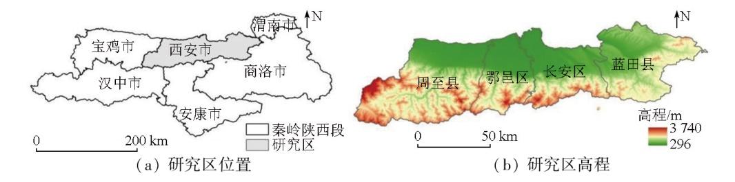
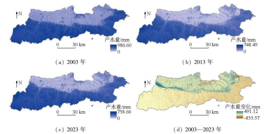
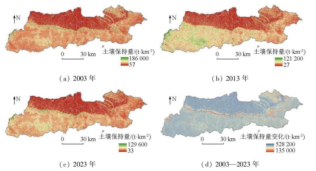
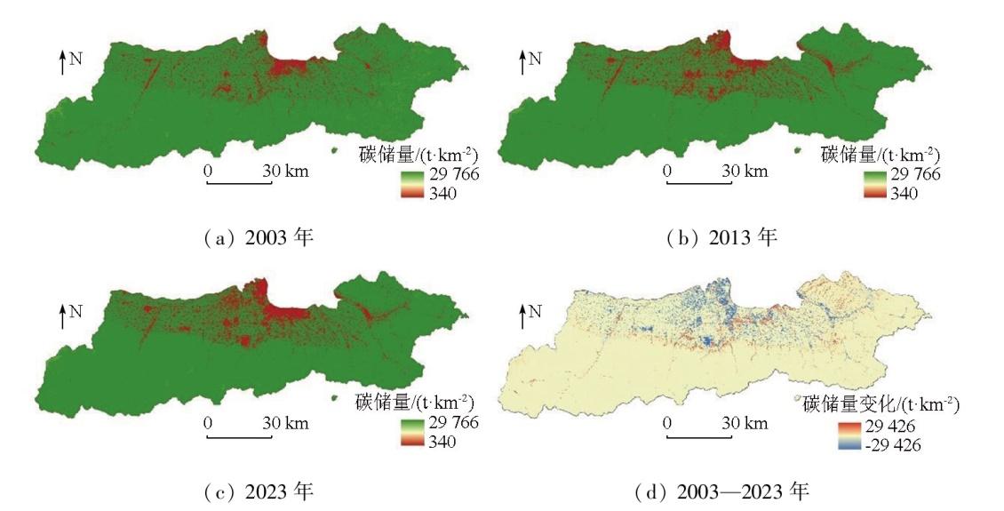
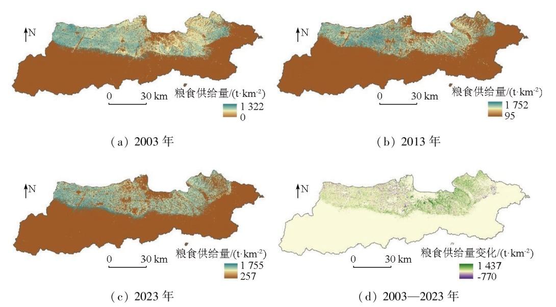
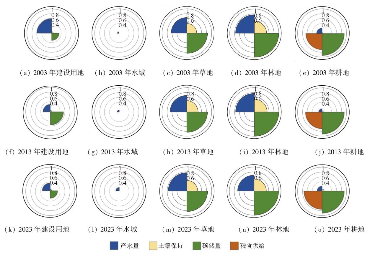
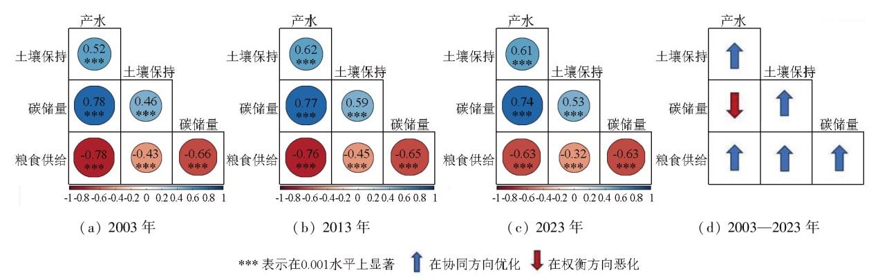
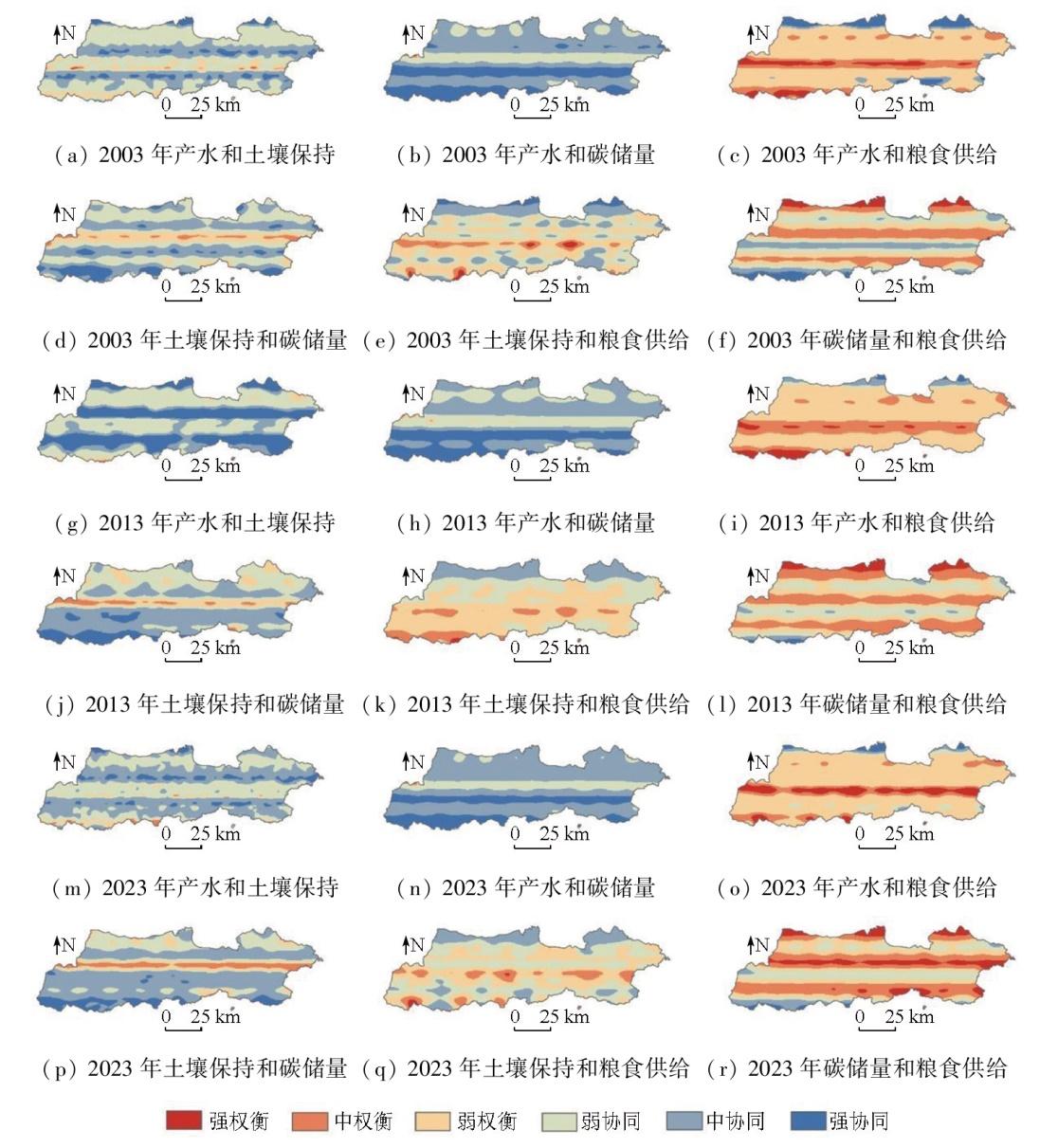
This study aims to investigate the spatiotemporal evolution and trade-off/synergy relationships of ecosystem services in the Xi'an section of the Qinling Mountains. To this end, it quantitatively assessed the spatiotemporal evolution patterns of four ecosystem services-water yield, soil conservation, carbon reserves, and food supply-from 2003 to 2023 based on the integrated valuation of ecosystem services and trade-offs (InVEST) model. By integrating Spearman's rank correlation coefficient and geographically weighted regression (GWR), this study identified and quantified trade-off/synergy relationships among ecosystem services. Finally, the impacts of changes in land use on ecosystem services were analyzed. The results showed that water yield and soil conservation generally showed a rapidly decreasing trend followed by a slow increase, while carbon reserves and food supply exhibited a slow decline. In addition, synergistic relationships were observed between water yield and soil conservation, between water yield and carbon reserves, and between carbon reserves and soil conservation. In contrast, trade-off relationships were identified between food supply and water production, soil conservation, and carbon reserves. In the study area, increases in forestland and grassland led to a diminution in water yield. The expansion of construction land and the loss of arable land resources directly triggered a reduction in carbon reserves, while an increase in forestland contributed to soil conservation. These findings can provide a scientific basis for the eco-environmental protection and sustainable development of the Qinling area.
ZHANG Yiwen , LI Fengxia , ZHANG Rui , FENG Xiaogang , LI Meng , HU Moqing . Spatiotemporal evolution and trade-off/synergy analysis of ecosystem services in the Xi’an section of the Qinling Mountains[J]. Remote Sensing for Natural Resources, 2025 , 37(6) : 191 -200 . DOI: 10.6046/zrzyyg.2024321
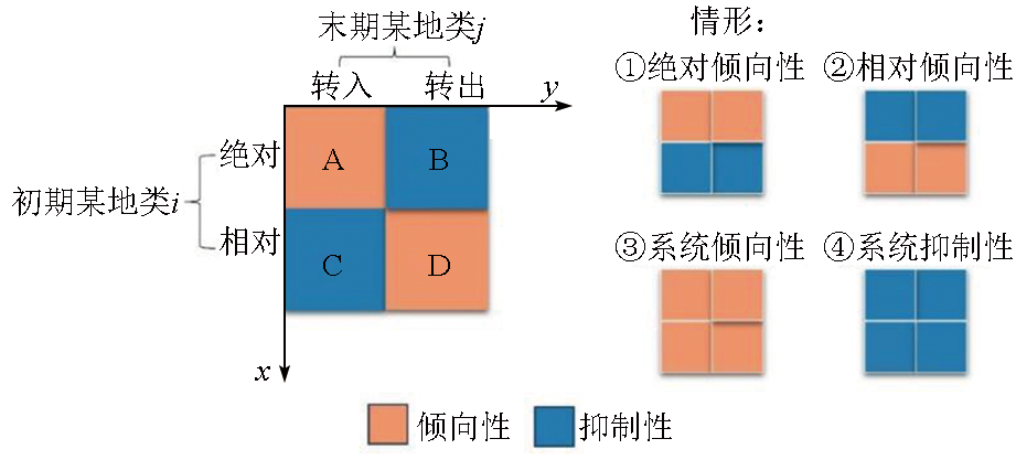
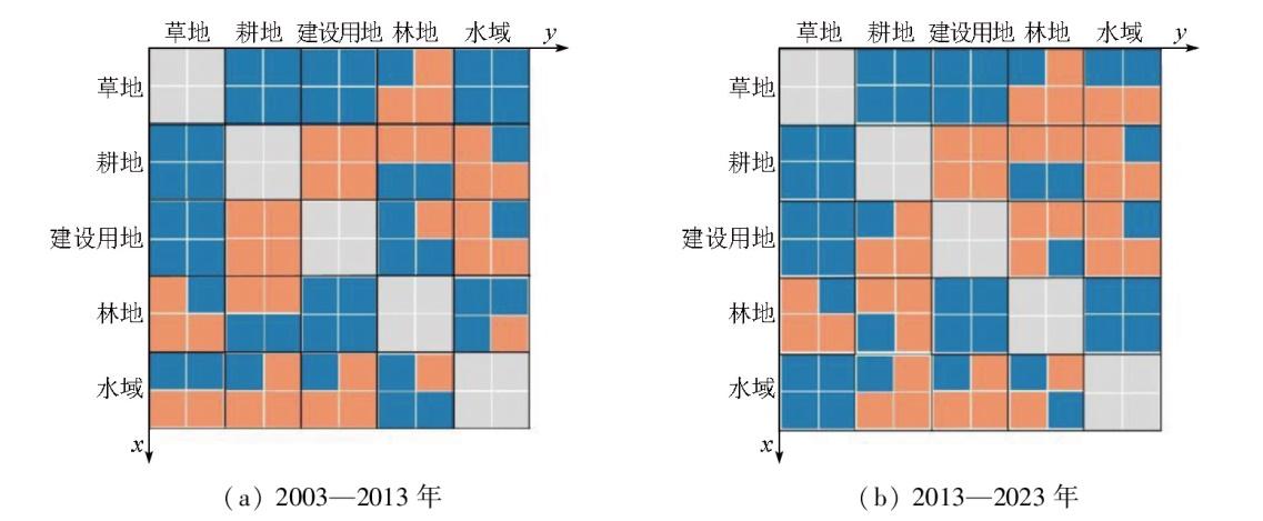
表1 不同强度类型下的地类变化判定标准Tab.1 Criteria for determining land use changes at different intensity types |
| 强度类型 | 地类流向 | 判定条件 | 趋势描述 |
|---|---|---|---|
| 绝对强度 | 获取转入 | 绝对转入强度>平均绝对转入强度 | 倾向于从地类i获得转入,反之受到抑制 |
| 均匀转出 | 绝对转出强度>平均绝对转出强度 | 倾向于转出为地类j,反之受到抑制 | |
| 相对强度 | 获取转入 | 相对转入强度>平均相对转入度 | 相对倾向于从地类i获得转入,反之受到抑制 |
| 均匀转出 | 相对转出强度>平均相对转入度 | 相对倾向于转出为地类j,反之受到抑制 |
表2 不同地类的碳密度数据Tab.2 Carbon density data of different land use types (t/hm2) |
| 类型 | 地上生物 量碳密度 | 地下生物 量碳密度 | 土壤碳密度 | 死亡有机 物碳密度 |
|---|---|---|---|---|
| 草地 | 39.99 | 97.99 | 113.17 | 0.50 |
| 耕地 | 52.68 | 91.42 | 122.80 | 0.70 |
| 建设用地 | 2.83 | 0.00 | 88.36 | 0.00 |
| 林地 | 48.03 | 131.29 | 116.34 | 2.00 |
| 水域 | 3.40 | 0.00 | 0.00 | 0.00 |
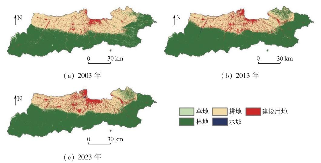
表3 土地利用类型面积及占比Tab.3 Area and proportion of land use types |
| 类型 | 2003年 | 2013年 | 2023年 | |||
|---|---|---|---|---|---|---|
| 面积/km2 | 占比/% | 面积/km2 | 占比/% | 面积/km2 | 占比/% | |
| 草地 | 138.85 | 1.77 | 25.26 | 0.32 | 31.75 | 0.40 |
| 耕地 | 2 556.74 | 32.60 | 1 929.38 | 24.60 | 1 977.13 | 25.21 |
| 建设用地 | 489.82 | 6.25 | 633.47 | 8.08 | 709.64 | 9.05 |
| 林地 | 4 638.90 | 59.14 | 5 226.24 | 66.63 | 5 105.56 | 65.10 |
| 水域 | 18.86 | 0.24 | 28.82 | 0.37 | 19.09 | 0.24 |
表4 单一类型土地利用动态度及综合土地利用动态度Tab.4 Dynamics degree of single land use and comprehensive land use (%) |
| 年份 | 草地 | 耕地 | 建设用地 | 林地 | 水域 | 综合 |
|---|---|---|---|---|---|---|
| 2003—2013年 | -8.18 | -2.45 | 2.93 | 1.27 | 5.28 | 0.94 |
| 2013—2023年 | 2.57 | -0.25 | 1.20 | -0.23 | -3.38 | 0.17 |
| 2003—2023年 | -7.71 | -2.27 | 4.49 | 1.01 | -0.12 | 0.88 |
表5 土地利用转移矩阵Tab.5 Land use transfer matrix (km2) |
| 2003年 | 2023年 | 转出 总计 | ||||
|---|---|---|---|---|---|---|
| 草地 | 耕地 | 建设用地 | 林地 | 水域 | ||
| 草地 | 19.34 | 2.75 | 1.59 | 108.84 | 0.23 | 113.41 |
| 耕地 | 0.43 | 1 776.73 | 380.38 | 399.14 | 8.21 | 788.16 |
| 建设用地 | 0.38 | 114.69 | 308.59 | 56.06 | 3.39 | 174.52 |
| 林地 | 11.47 | 81.52 | 13.06 | 4 536.28 | 1.55 | 107.60 |
| 水域 | 0.03 | 3.41 | 5.81 | 3.60 | 5.69 | 12.85 |
| 转入总计 | 12.31 | 202.37 | 400.84 | 567.64 | 13.38 | 1 196.54 |
| [1] |
傅伯杰, 周国逸, 白永飞, 等. 中国主要陆地生态系统服务功能与生态安全[J]. 地球科学进展, 2009, 24(6):571-576.
|
| [2] |
戴尔阜, 王晓莉, 朱建佳, 等. 生态系统服务权衡/协同研究进展与趋势展望[J]. 地球科学进展, 2015, 30(11):1250-1259.
|
| [3] |
王建庆. 东南沿海地区城镇土地利用效益评价研究——以浙江省百强县为例[D]. 宁波: 宁波大学, 2014.
|
| [4] |
|
| [5] |
|
| [6] |
|
| [7] |
|
| [8] |
于媛, 韩玲, 李明玉, 等. 哈长城市群生态系统服务时空特征及其权衡/协同关系研究[J]. 水土保持研究, 2021, 28(2):293-300.
|
| [9] |
龙文芹, 职露, 郭娅迪, 等. 西洞庭湖自然保护区2000—2020 年间碳储量时空演变及成因分析[J]. 自然资源遥感, 2024, 36(4):185-192.doi:10.6046/zrzyyg.2023265.
|
| [10] |
崔璐. 秦岭陕西段生态系统服务评估及多情景预测研究[D]. 西安: 长安大学, 2023.
|
| [11] |
丘海红, 胡宝清, 张泽. 基于土地利用变化的广西近20年生态系统服务价值研究[J]. 环境工程技术学报, 2022, 12(5):1455-1465.
|
| [12] |
李丹, 周嘉, 战大庆. 黑龙江省耕地时空变化及驱动因素分析[J]. 地理科学, 2021, 41(7):1266-1275.
|
| [13] |
牛乐乐, 张必成, 贾天忠, 等. 青海省海西州土地利用变化强度分析与稳定性研究[J]. 水土保持学报, 2021, 35(2):152-159.
|
| [14] |
朱灵伟, 陈晨, 彭云飞, 等. 基于LUCC强度图谱的耕地时空演变模式研究[J]. 中国国土资源经济, 2024, 37(12):52-63.
|
| [15] |
李帅呈, 龚健, 杨建新, 等. 兰西城市群土地利用/覆被变化模式特征——基于强度分析框架[J]. 资源科学, 2023, 45(3):480-493.
|
| [16] |
范亚宁, 刘康, 陈姗姗, 等. 秦岭北麓陆地生态系统水源涵养功能的空间格局[J]. 水土保持通报, 2017, 37(2):50-56.
|
| [17] |
周苹苹, 罗艺, 宋小燕, 等. 基于InVEST-PLUS模型的陕西省水源涵养量估算及预测[J]. 水土保持学报, 2024, 38(3):187-194.
|
| [18] |
翟睿洁, 赵文武, 贾立志. 基于RUSLE、InVEST 和USPED 的土壤侵蚀量估算对比研究——以陕北延河流域为例[J]. 农业现代化研究, 2020, 41(6):1059-1068.
|
| [19] |
李倩, 王成军, 冯涛, 等. 基于SD-PLUS耦合模型的陕西省土地利用变化及碳储量多情景预测[J]. 水土保持学报, 2024, 38(3):195-206,215.
|
| [20] |
赵文亮, 贺振, 贺俊平, 等. 基于MODIS-NDVI的河南省冬小麦产量遥感估测[J]. 地理研究, 2012, 31(12):2310-2320.
|
| [21] |
周凡, 周冬梅, 金银丽, 等. 疏勒河流域生态系统服务供需空间匹配特征[J]. 干旱区地理, 2023, 46(3):471-480.
|
| [22] |
武文欢, 彭建, 刘焱序, 等. 鄂尔多斯市生态系统服务权衡与协同分析[J]. 地理科学进展, 2017, 36(12):1571-1581.
|
| [23] |
刘纪远, 宁佳, 匡文慧, 等. 2010—2015年中国土地利用变化的时空格局与新特征[J]. 地理学报, 2018, 73(5):789-802.
|
| [24] |
魏培洁, 吴明辉, 贾映兰, 等. 基于InVEST模型的疏勒河上游产水量时空变化特征分析[J]. 生态学报, 2022, 42(15):6418-6429.
|
| [25] |
胡文敏, 杨睿瀚, 贾冠宇, 等. 长江流域产水功能对土地利用变化的响应及其驱动因素[J]. 生态学报, 2022, 42(17):7011-7027.
|
| [26] |
贾纪昂, 郭伟玲, 徐刘洋, 等. 耦合PLUS-InVEST-GeoDetector模型的安徽省碳储量时空演变及驱动力分析[J]. 环境科学, 2025, 46(3):1703-1715.
|
| [27] |
|
/
| 〈 |
|
〉 |