
Remote Sensing for Natural Resources >
Remote sensing-based assessment of ecological quality in open-pit coal mining areas based on the pressure-state-response and time series prediction models
Received date: 2024-10-08
Revised date: 2025-06-12
Online published: 2026-06-03
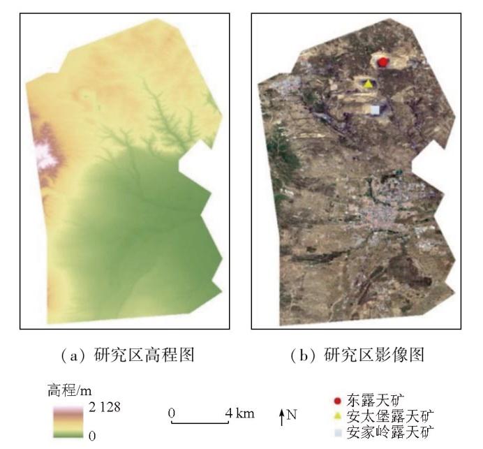
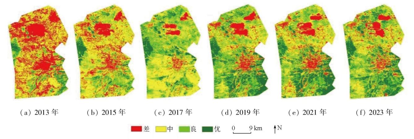
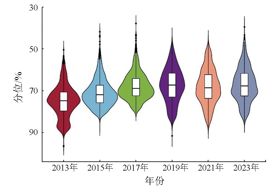
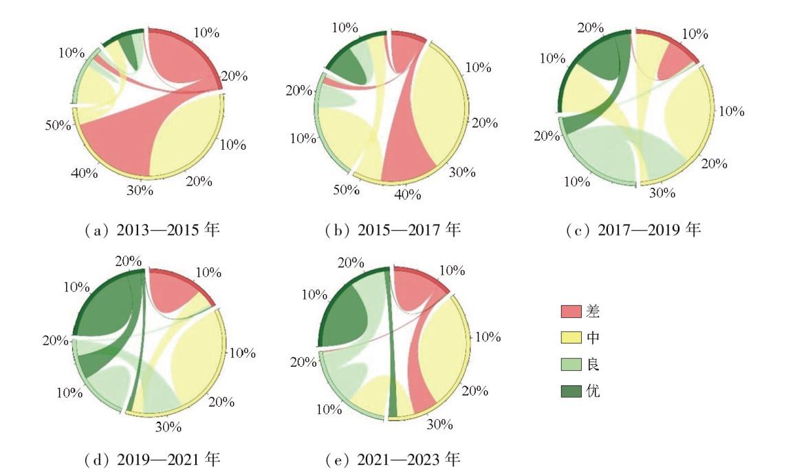
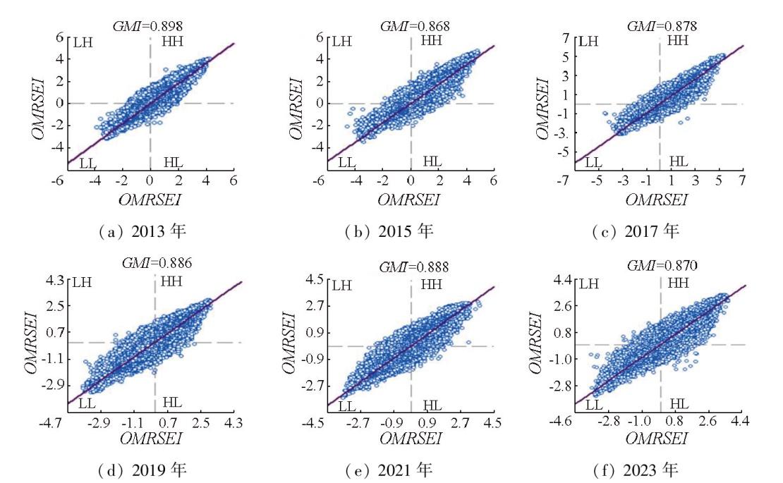
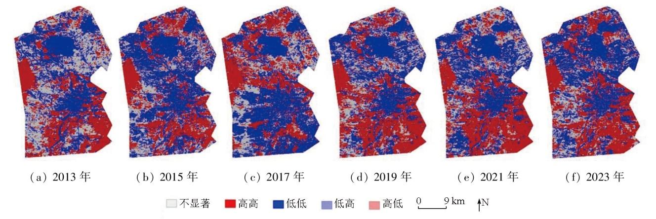
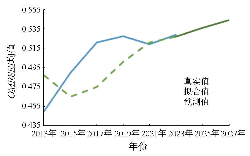
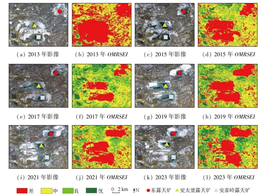
To quantify the mining disturbance of open-pit coal mines to surrounding ecosystems, this study investigated the Pingshuo mining area in Shanxi Province. Based on the pressure-state-response (PSR) model, seven types of assessment indicators were selected to construct the remote sensing ecological index of open-pit coal mining area (OMRSEI) through combination weighting. The validity of the OMRSEI was verified through correlation and comparative analyses. Moreover, the trend of ecological evolution in the study area for the next two years was predicted using the exponential smoothing method. The results indicate that the OMRSEI exhibited significant spatial correlation and validity, establishing it as an effective remote sensing indicator for ecological assessment in open-pit coal mining areas. The study area manifested an overall enhanced ecological quality from 2013 to 2023. Specifically, the Antaibao and Anjialing open-pit coal mines witnessed continuously improved ecological quality due to the progressive restoration of waste dumps. In contrast, the Dong open-pit coal mine displayed an ecological quality trend characterized by a first decline and then recovery. The average OMRSEI of the study area is predicted to continuously rise from 2025 to 2027, indicating sustained enhancement in ecological quality.
LIU Jinyu , HU Jinshan , KANG Jianrong , ZHU Yihu , WANG Shengli . Remote sensing-based assessment of ecological quality in open-pit coal mining areas based on the pressure-state-response and time series prediction models[J]. Remote Sensing for Natural Resources, 2025 , 37(6) : 182 -190 . DOI: 10.6046/zrzyyg.2024323
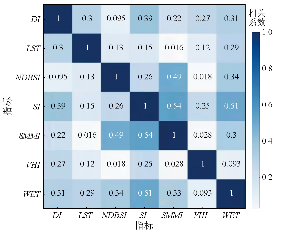
表1 生态指标计算方法Tab.1 Method for calculating ecological indicators |
| 一级 指标 | 二级 指标 | 效应① | 计算公式 |
|---|---|---|---|
| 压力 | DI | - | DI=R-N |
| NDBSI | - | SI1=$\frac{({S}_{1}+R)-(B+N)}{({S}_{1}+R)+(B+N)}$ IBI=$\frac{2{S}_{1}/({S}_{1}+N)-[N/(N+R)+G/(G+{S}_{1}\left)\right]}{2{S}_{1}/({S}_{1}+N)+[N/(N+R)+G/(G+{S}_{1}\left)\right]}$ NDBSI=(SI+IBI)/2 | |
| 状态 | VHI | + | NDSVI=(S1-R)/(S1+R) NRI=N/G NDVI=(N-R)/(N+R) VHI=PC1(NDVI,NDSVI,NRI) |
| SMMI | + | SMMI=$\sqrt[ ]{(N+{S}_{1})/2}$ | |
| 响应 | LST | - | L=gain×DN+bias T=K2/ln(K1/L+1) LST=T/[1+(λT/ρ)ln ε]-273.15 |
| WET | + | WET=0.151 1B+0.197 3G+0.328 3R+ 0.340 7N-0.711 7S1-0.455 9S2 | |
| SI2 | - | SI2=$\sqrt[ ]{B\times R}$ |
①“+”表示该指标为正向指标,“-”表示该指标为负向指标; R,G,B,N,S1以及S2分别为Landsat8 OLI/TIRS的红光、绿光、蓝光、近红外、短波红外1波段和短波红外2波段的反射率; PC1为第一主成分; DN为像元灰度值; gain和bias分别为热红外波段的增益与偏置值; K1和K2为热红外波段转换常数; λ为地表发射辐射的波长; ε为地表比辐射率; ρ为1.438×10⁻² mK。 |
表2 研究区OMRSEI各指标权重Tab.2 The weights of each index of OMRSEI in the research area |
| 一级指标 | 二级指标 | 熵权法权重 | 层次分析 法权重 | 组合权重 |
|---|---|---|---|---|
| 压力 | DI | 0.089 2 | 0.187 5 | 0.138 4 |
| NDBSI | 0.074 0 | 0.250 0 | 0.162 0 | |
| 状态 | VHI | 0.734 7 | 0.187 5 | 0.461 1 |
| SMMI | 0.021 9 | 0.125 0 | 0.073 5 | |
| 响应 | LST | 0.045 8 | 0.125 0 | 0.085 4 |
| WET | 0.016 4 | 0.062 5 | 0.039 5 | |
| SI2 | 0.017 9 | 0.062 5 | 0.040 2 |
表3 研究区OMRSEI阈值Tab.3 OMRSEI thresholds of the research area |
| 研究年份 | 阈值1 | 阈值2 | 阈值3 |
|---|---|---|---|
| 2013年 | 0.400 1 | 0.475 0 | 0.540 8 |
| 2015年 | 0.433 0 | 0.529 5 | 0.577 8 |
| 2017年 | 0.481 0 | 0.581 2 | 0.631 2 |
| 2019年 | 0.431 5 | 0.518 6 | 0.562 1 |
| 2021年 | 0.454 8 | 0.537 4 | 0.596 4 |
| 2023年 | 0.461 3 | 0.546 8 | 0.599 9 |
| 均值 | 0.443 6 | 0.531 4 | 0.584 7 |
| [1] |
|
| [2] |
李树志, 李学良, 尹大伟. 碳中和背景下煤炭矿山生态修复的几个基本问题[J]. 煤炭科学技术, 2022, 50(1):286-292.
|
| [3] |
张成业, 李军, 雷少刚, 等. 矿区生态环境定量遥感监测研究进展与展望[J]. 金属矿山, 2022(3):1-27.
|
| [4] |
于洋, 陈炳乾, 花奋奋, 等. 矿山地质环境灾变与保护修复研究现状与展望[J]. 金属矿山, 2024(3):1-18.
|
| [5] |
|
| [6] |
|
| [7] |
|
| [8] |
孙宏飞, 李永华, 姬艳芳, 等. 湘西汞矿区土壤中重金属的空间分布特征及其生态环境意义[J]. 环境科学, 2009, 30(4):1159-1165.
|
| [9] |
|
| [10] |
|
| [11] |
徐占军, 侯湖平, 张绍良, 等. 采矿活动和气候变化对煤矿区生态环境损失的影响[J]. 农业工程学报, 2012, 28(5):232-240.
|
| [12] |
徐涵秋. 区域生态环境变化的遥感评价指数[J]. 中国环境科学, 2013, 33(5):889-897.
|
| [13] |
秦璐, 陈炳乾, 于洋, 等. 基于遥感生态指数的矿井关闭前后生态环境时空变化规律研究[J]. 金属矿山, 2023(3):242-249.
|
| [14] |
陈杏闪, 陈宇, 陆慧, 等. 义能矿区景观格局及生态环境时空动态遥感监测[J]. 遥感技术与应用, 2024, 39(2):426-434.
|
| [15] |
岳佳乐, 胡晋山, 郦嘉辉, 等. 基于MAGA-PPC模型的胡家河矿区生态环境质量评价[J]. 金属矿山, 2023(4):236-244.
|
| [16] |
刘英, 胡霄, 岳辉, 等. 基于时间序列模型的戈壁荒漠露天矿生态环境评价[J]. 煤炭科学技术, 2023, 51(12):125-139.
|
| [17] |
钟安亚, 孙娟, 胡春明, 等. 基于RSEI的北京王平煤矿生态环境修复效果评估及预测[J]. 矿业安全与环保, 2023, 50(4):89-96.
|
| [18] |
王锦洋, 卢才武, 李发本, 等. 基于PSR和GA-Elman模型的露天矿区生态安全评价研究[J]. 中国矿业, 2020, 29(2):65-71.
|
| [19] |
|
| [20] |
吴舒雁, 朱庆林, 武文. 基于PSR模型的大连湾海岸带生态安全评价研究[J/OL]. 海洋湖沼通报, 2024:1-10.(2024-04-01).https://kns.cnki.net/kcms/detail/37.1141.P.20240401.1502.002.html.
|
| [21] |
冯海英, 冯仲科, 冯海霞. 一种基于差值指数的颗粒物PM2.5浓度反演新方法[J]. 光谱学与光谱分析, 2018, 38(10):3012.
|
| [22] |
|
| [23] |
|
| [24] |
|
| [25] |
|
| [26] |
方时姣, 肖权. 中国区域生态福利绩效水平及其空间效应研究[J]. 中国人口·资源与环境, 2019, 29(3):1-10.
|
| [27] |
|
| [28] |
朔州市人民政府. 关于印发朔州市“十四五”生态环境保护规划的通知:朔政发[2022]36号[A/OL].(2022-8-26)[2024-6-12].http://szxxgk.shuozhou.gov.cn/zfwj_1/202212/t20221216_420310.shtml.
Shuozhou Municipal People’s Government. Notice on the issuance of the “14th Five-Year Plan” ecological and environmental protection plan of Shuozhou City:Shuo Zheng Fa [2022]No.36[A/OL].(2022-8-26)[2024-6-12].http://szxxgk.shuozhou.gov.cn/zfwj_1/202212/t20221216_420310.shtml.
|
| [29] |
张静, 杨丽萍, 贡恩军, 等. 基于谷歌地球引擎和改进型遥感生态指数的西安市生态环境质量动态监测[J]. 生态学报, 2023, 43(5):2114-2127.
|
/
| 〈 |
|
〉 |