
Remote Sensing for Natural Resources >
SBAS-InSAR-based long time-series deformation monitoring and landslide hazard identification in the Baihetan reservoir area
Received date: 2024-11-12
Revised date: 2025-06-05
Online published: 2026-06-03
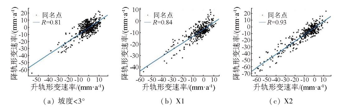
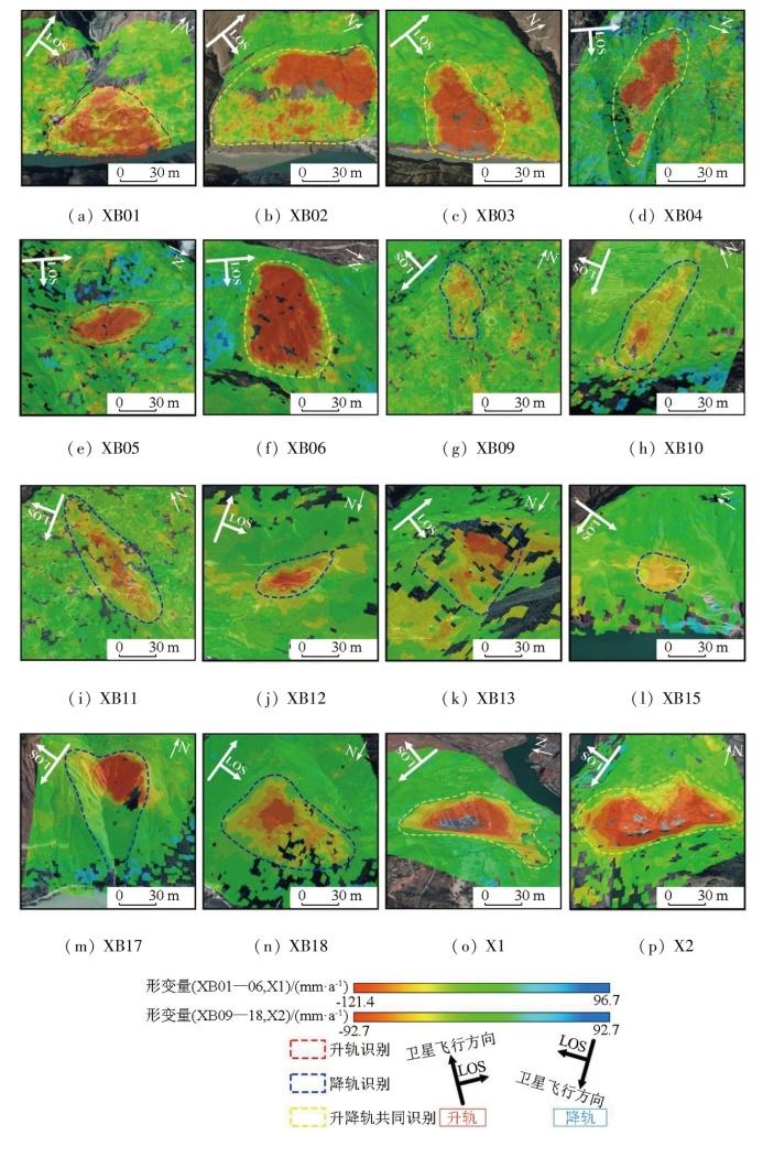
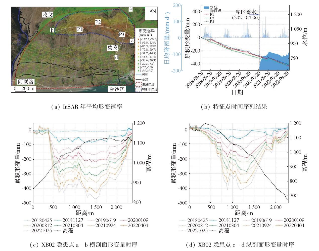
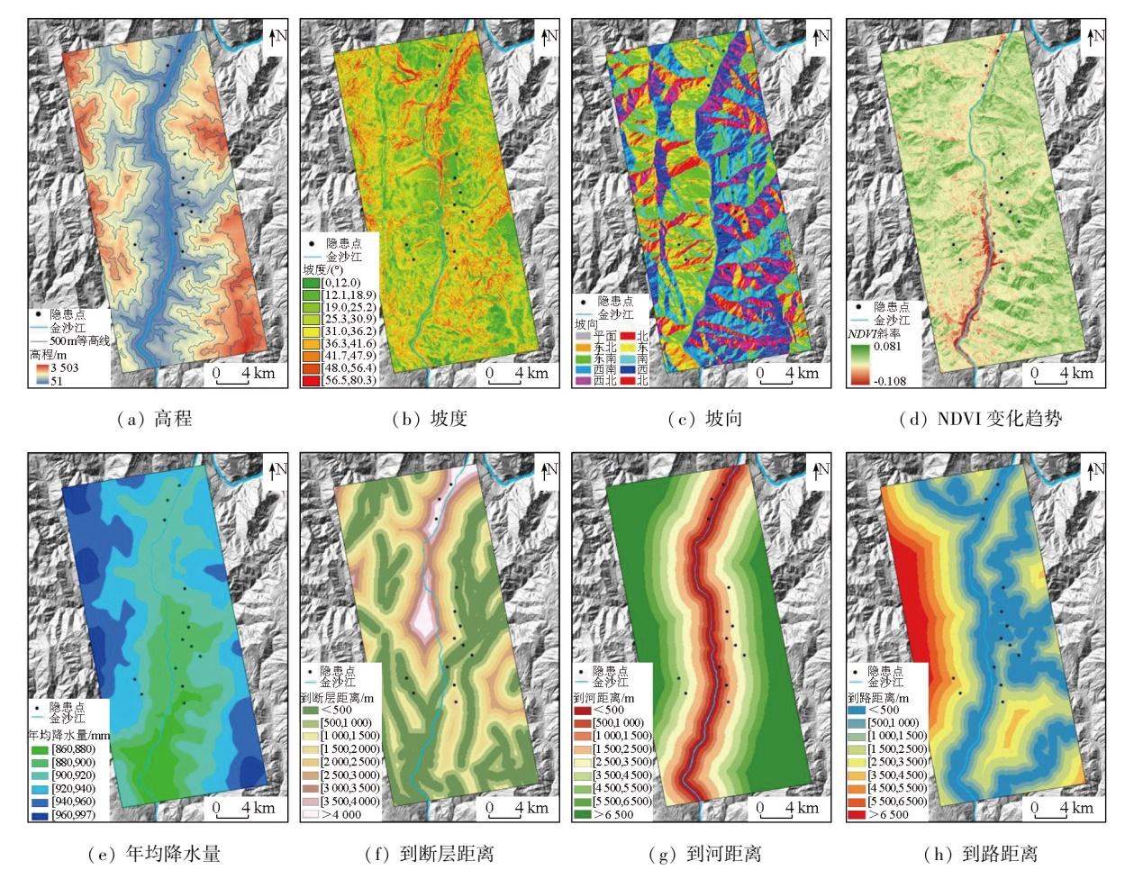
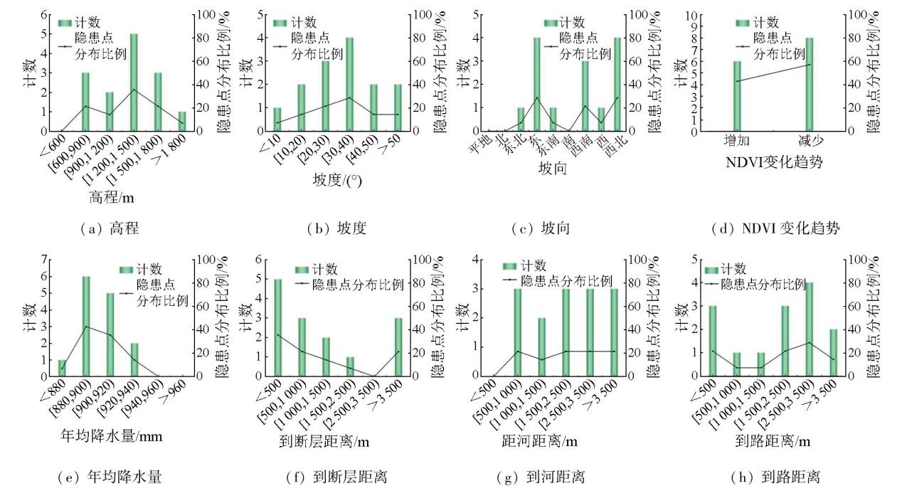
The reservoir area of the Baihetan hydropower station (also referred to as the Baihetan reservoir area) suffers from frequent geologic hazards. However, there is a lack of monitoring studies on the central area and lower reaches of the hydropower station. Based on the ascending and descending synthetic aperture Radar (SAR) images from the Sentinel-1A satellite, this study performed deformation monitoring and landslide hazard identification in the Baishitan-Yezhutang section of the Baihetan reservoir area using the small baseline subset-interferometric synthetic aperture Radar (SBAS-InSAR) method supported by the generic atmospheric correction online service for InSAR (GACOS). Moreover, this study conducted cross-validation of deformation data from ascending and descending SAR images for low-slope zones. It investigated the spatial distribution of landslide hazards and the movement patterns of typical hazard sites in the study area. Finally, it examined the impacts of factors influencing geologic hazards on the distribution of these hazard sites. The results indicate that the deformation data from ascending and descending SAR images for low-slope zones can be used for cross-validation. Based on the deformation detection results from time-series InSAR and the optical images from Google Earth, 16 landslide hazards were identified, including 14 slow-moving landslides and two significant deformation hazards induced by human engineering activities. Integrating the data of ascending and descending SAR images validated the reliability of deformation results and also enhanced the effectiveness of landslide hazard identification. The analysis of the movement patterns at typical hazard sites indicates a correlation between deformation acceleration and seasonal rainfall. The statistical analysis of factors influencing geologic hazards in the study area reveals that the formation of hazard sites is driven by multiple factors, with varying dominant factors and degrees of influence across different hazards.
YU Bing , ZHANG Chunyu , WANG Jinri , LIU Guoxiang , DAI Keren , MA Deying . SBAS-InSAR-based long time-series deformation monitoring and landslide hazard identification in the Baihetan reservoir area[J]. Remote Sensing for Natural Resources, 2025 , 37(6) : 156 -168 . DOI: 10.6046/zrzyyg.2024370
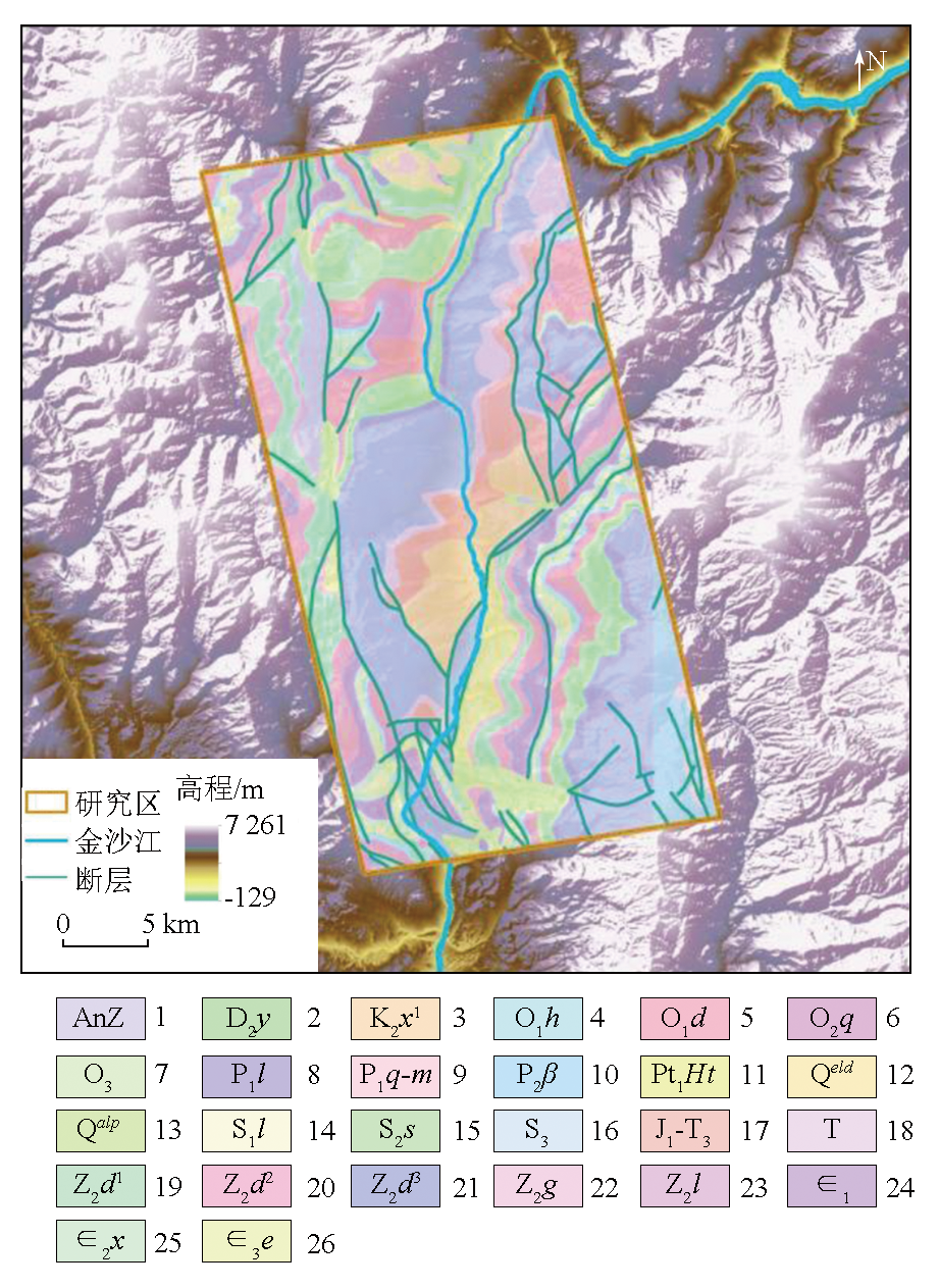
图2 研究区地质图1-前震旦系; 2-泥盆系中统幺棚子组; 3-白垩系下统小坝组下段; 4-奥陶系下统红石崖组; 5-奥陶系中统大箐组; 6-奥陶系中统巧家组; 7-奥陶系上统; 8-二叠系下统梁山组; 9-二叠系下统栖霞-茅口组; 10-二叠系上统峨眉山玄武岩; 11-古元古界会理群通安组; 12-第四系残坡积层; 13-第四系冲洪积层; 14-志留系下统龙马溪组; 15志留系中统石门坎组; 16-志留系上统; 17-三叠系上统—侏罗系下统; 18-三叠系; 19-震旦系上统灯影组下段; 20-震旦系上统灯影组中段; 21-震旦系上统灯影组上段; 22-震旦系上统观音崖组; 23-震旦系上统列古六组; 24-寒武系下统; 25-寒武系中统西王庙组; 26-寒武系上统二道水组 Fig.2 Geological map of the study area |
表1 Sentinel-1A数据主要参数Tab.1 Main parameters of Sentinel-1A data |
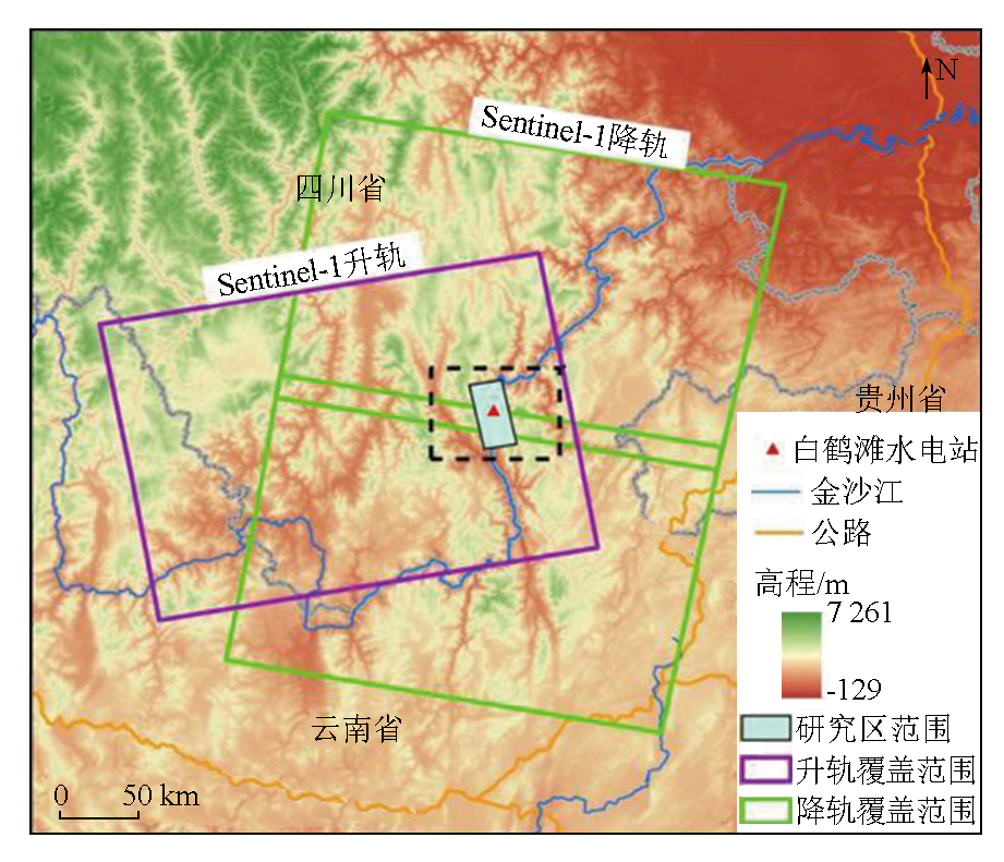
| 卫星 | 轨道 | 波长/cm | 入射角/(°) | 影像获取时间 | 重访周期/d | 空间分辨率/m | 极化方式 |
|---|---|---|---|---|---|---|---|
| Sentinel-1A | 升轨 | 5.6 | 44.0 | 2018-03-10—2022-10-25 | 12 | 5×20 | VV |
| Sentinel-1A | 降轨 | 5.6 | 39.4 | 2018-03-22—2022-10-27 | 12 | 5×20 | VV |
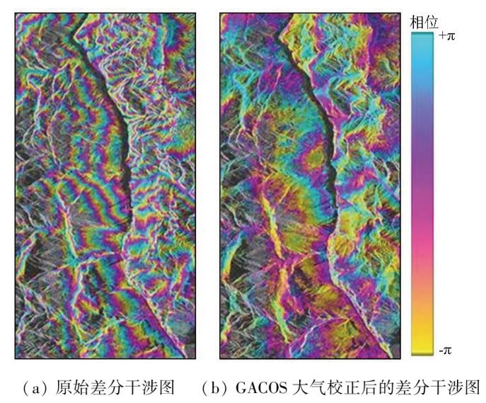
ϕGACOS,i,j(x,r)=ϕGACOS,j(x,r)-ϕGACOS,i(x,r)。
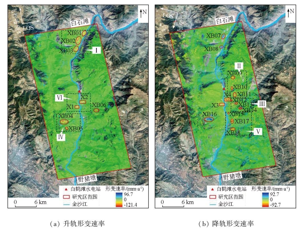
表2 隐患点详细信息Tab.2 Detailed information of potential hazards |
| 区域 | InSAR识别形变区编号 | 形变区名称 | LOS向最大形 变速率/(mm·a-1) | 地理位置 | 升/降轨 | 坡向 | 类型 |
|---|---|---|---|---|---|---|---|
| 区域Ⅰ | XB01 | 麻地坪 | -62.0 | 27°22'12″N,102°54'54″E | 升 | 东南 | 潜在滑坡 |
| XB02/XB07 | 废窝 | -112.1 | 27°21'11″N,102°53'55″E | 升、降 | 东 | 潜在滑坡 | |
| XB03/XB08 | 冯家坪村 | -83.9 | 27°19'47″N,102°53'51″E | 升、降 | 东 | 潜在滑坡 | |
| 区域Ⅱ | XB09 | 菜园子 | -41.3 | 27°10'26″N,102°55'33″E | 降 | 西南 | 潜在滑坡 |
| XB10 | 大寨村 | -44.9 | 27°13'23″N,102°55'23″E | 降 | 西南 | 潜在滑坡 | |
| XB11 | 帽子田 | -51.7 | 27°12'23″N,102°55'50″E | 降 | 西南 | 潜在滑坡 | |
| 区域Ⅲ | XB12 | 大花地 | -53.0 | 27°11'34″N,102°55'23″E | 降 | 西北 | 潜在滑坡 |
| XB13 | 塘拉者 | -49.0 | 27°11'05″N,102°56'05″E | 降 | 西北 | 潜在滑坡 | |
| XB06/XB14 | 付家岩脚 | -86.7 | 27°10'26″N,102°56'45″E | 升、降 | 东北 | 潜在滑坡 | |
| 区域Ⅳ | XB04/XB16 | 干田坝 | -121.4 | 27°08'49″N,102°51'40″E | 升、降 | 东 | 潜在滑坡 |
| XB05 | 立家粱子 | -90.6 | 27°07'47″N,102°52'17″E | 升 | 东 | 潜在滑坡 | |
| 区域Ⅴ | XB15 | 子油树 | -33.4 | 27°09'36″N,102°54'53″E | 降 | 西 | 潜在滑坡 |
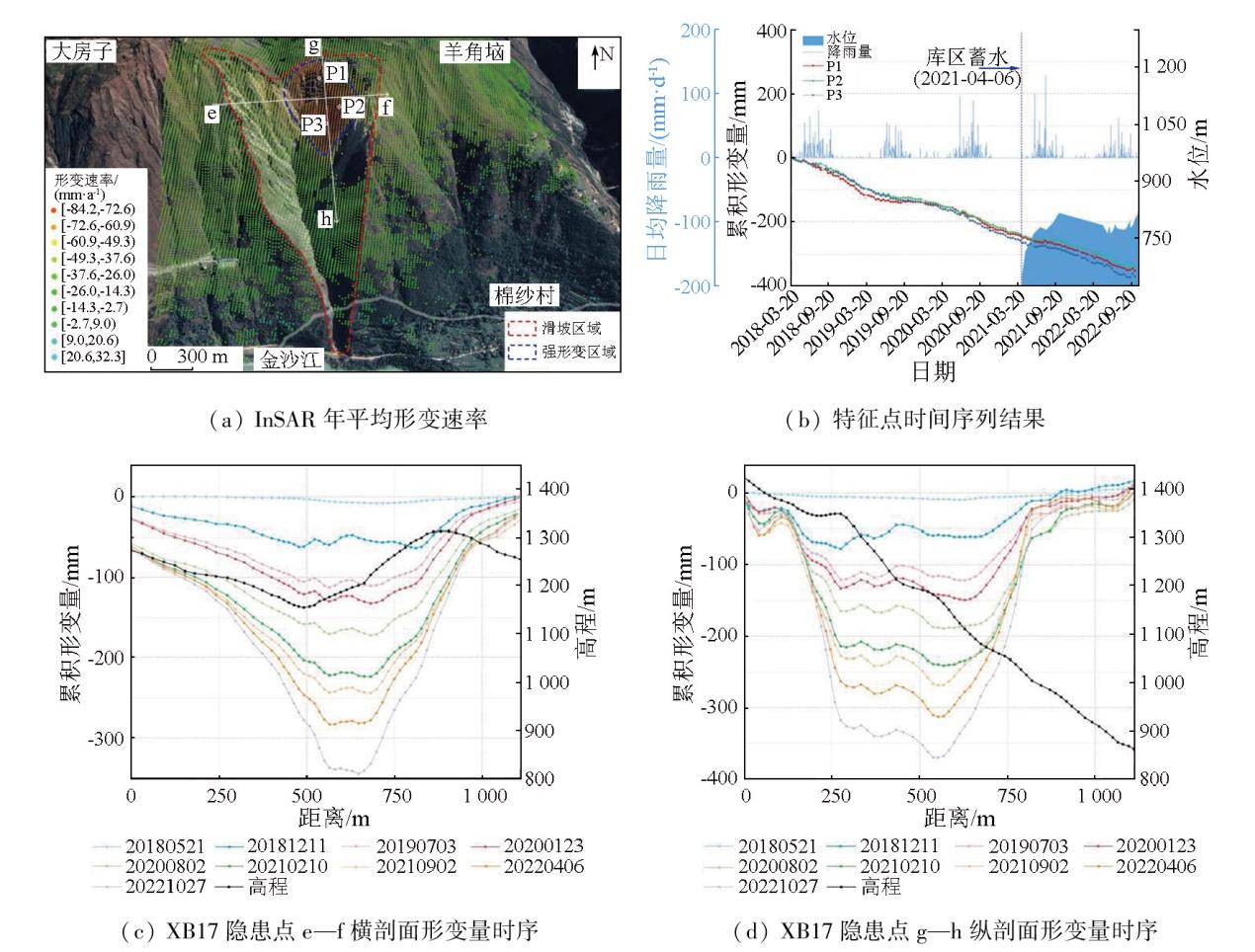
| XB17 | 棉纱村 | -84.2 | 27°08'23″N,102°55'26″E | 降 | 西北 | 潜在滑坡 | |
| XB18 | 建设村 | -46.5 | 27°07'14″N,102°55'33″E | 降 | 西北 | 潜在滑坡 | |
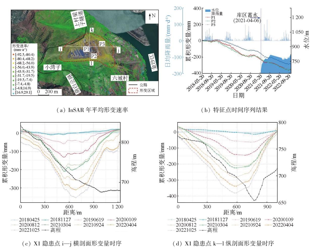
| 区域Ⅵ | X1/X3 | 六城村 | -92.5 | 27°10'59″N,102°53'59″E | 升、降 | — | 地表沉降 |
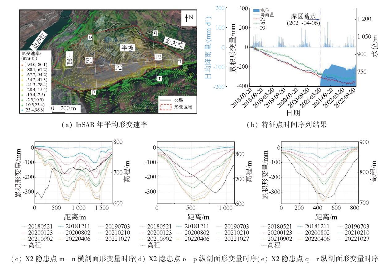
| X2/X4 | 半坡 | -93.0 | 27°11'41″N,102°54'39″E | 升、降 | — | 地表沉降 |
| [1] |
刘晓杰. 星载雷达遥感广域滑坡早期识别与监测预测关键技术研究[D]. 西安: 长安大学, 2022.
|
| [2] |
戴可人, 吴明堂, 卓冠晨, 等. 西南山区大型水电工程库岸滑坡InSAR早期识别与监测研究进展[J]. 地球科学与环境学报, 2023, 45(3):559-577.
|
| [3] |
康亚, 赵超英, 张勤, 等. InSAR滑坡探测技术研究——以金沙江乌东德水电站段为例[J]. 大地测量与地球动力学, 2018, 38(10):1053-1057.
|
| [4] |
许强. 对地质灾害隐患早期识别相关问题的认识与思考[J]. 武汉大学学报(信息科学版), 2020, 45(11):1651-1659.
|
| [5] |
许强, 蒲川豪, 赵宽耀, 等. 延安新区地面沉降时空演化特征时序InSAR监测与分析[J]. 武汉大学学报(信息科学版), 2021, 46(7):957-969.
|
| [6] |
|
| [7] |
|
| [8] |
|
| [9] |
戴可人, 沈月, 吴明堂, 等. 联合InSAR与无人机航测的白鹤滩库区蓄水前地灾隐患广域识别[J]. 测绘学报, 2022, 51(10):2069-2082.
|
| [10] |
吴明堂, 崔振华, 易小宇, 等. 白鹤滩库区象鼻岭—野猪塘段地质灾害综合遥感识别[J]. 长江科学院院报, 2023, 40(4):155-163.
|
| [11] |
顿佳伟, 冯文凯, 易小宇, 等. 白鹤滩库区蓄水前活动性滑坡InSAR早期识别研究——以葫芦口镇至象鼻岭段为例[J]. 工程地质学报, 2023, 31(2):479-492.
|
| [12] |
|
| [13] |
|
| [14] |
|
| [15] |
朱赛楠, 殷跃平, 王猛, 等. 金沙江结合带高位远程滑坡失稳机理及减灾对策研究——以金沙江色拉滑坡为例[J]. 岩土工程学报, 2021, 43(4):688-697.
|
| [16] |
|
| [17] |
李丹. 基于时序InSAR技术的恩施沙子坝滑坡形变监测与区域易发性评价[D]. 武汉: 华中师范大学, 2021.
|
| [18] |
|
| [19] |
|
| [20] |
|
| [21] |
刘友奉. 基于DS-InSAR的充填开采区地表沉降监测方法研究[D]. 徐州: 中国矿业大学, 2021.
|
| [22] |
李松林, 许强, 汤明高, 等. 三峡库区滑坡空间发育规律及其关键影响因子[J]. 地球科学, 2020, 45(1):341-354.
|
| [23] |
方苗, 张金龙, 徐瑱. 基于GIS和Logistic回归模型的兰州市滑坡灾害敏感性区划研究[J]. 遥感技术与应用, 2011, 26(6):845-854.
|
| [24] |
|
| [25] |
李媛茜, 张毅, 苏晓军, 等. 白龙江流域潜在滑坡InSAR识别与发育特征研究[J]. 遥感学报, 2021, 25(2):677-690.
|
| [26] |
胡俊. 基于现代测量平差的InSAR三维形变估计理论与方法[D]. 长沙: 中南大学, 2013.
|
| [27] |
曹中山. 基于易发性和临界降雨阈值的滑坡危险性预警建模研究[D]. 南昌: 南昌大学, 2020.
|
| [28] |
|
| [29] |
姚鑫, 邓建辉, 刘星洪, 等. 青藏高原泛三江并流区活动性滑坡InSAR初步识别与发育规律分析[J]. 工程科学与技术, 2020, 52(5):16-37.
|
| [30] |
程海琴, 陈强, 刘国祥, 等. 短基线InSAR探测龙门山主断裂带两侧震后雨期的滑坡空间分布特征[J]. 测绘学报, 2014, 43(9):931-938.
|
/
| 〈 |
|
〉 |