
Remote Sensing for Natural Resources >
Deformation monitoring using time-series InSAR with dual-polarization optimization
Received date: 2024-10-19
Revised date: 2025-01-23
Online published: 2026-06-03
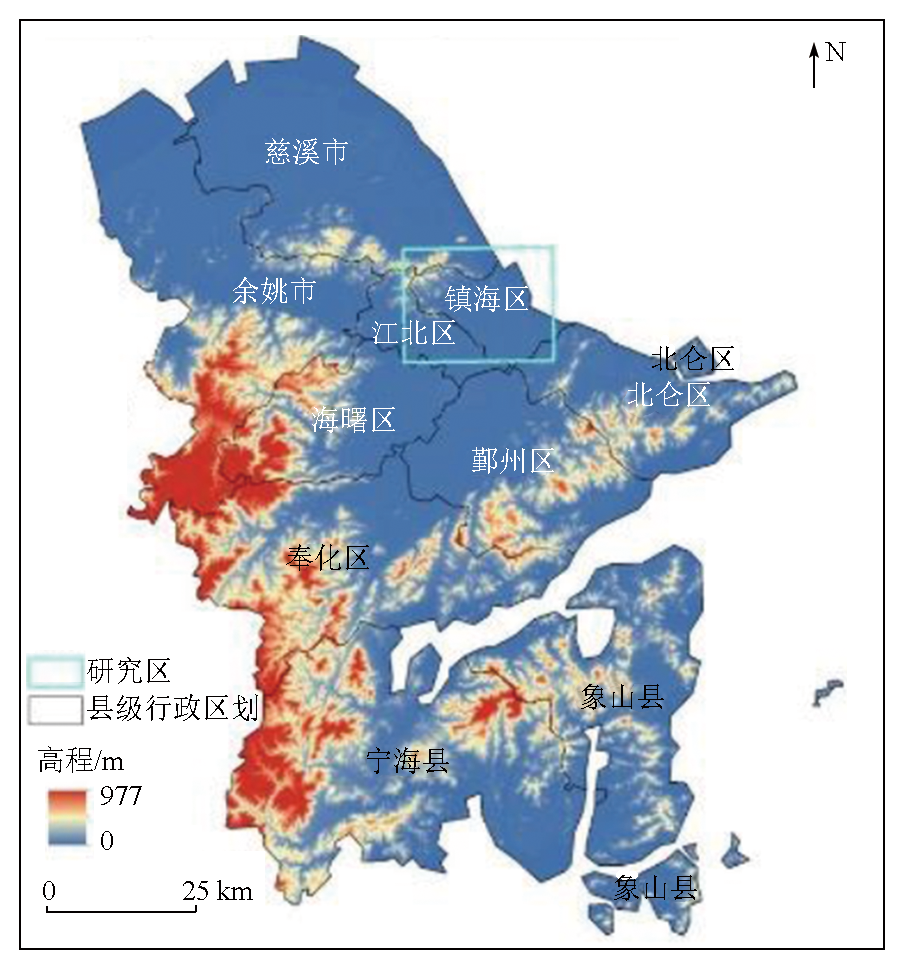
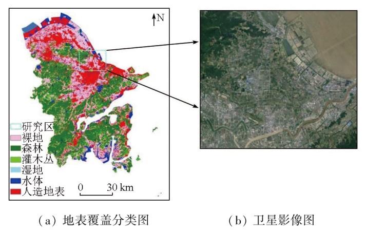
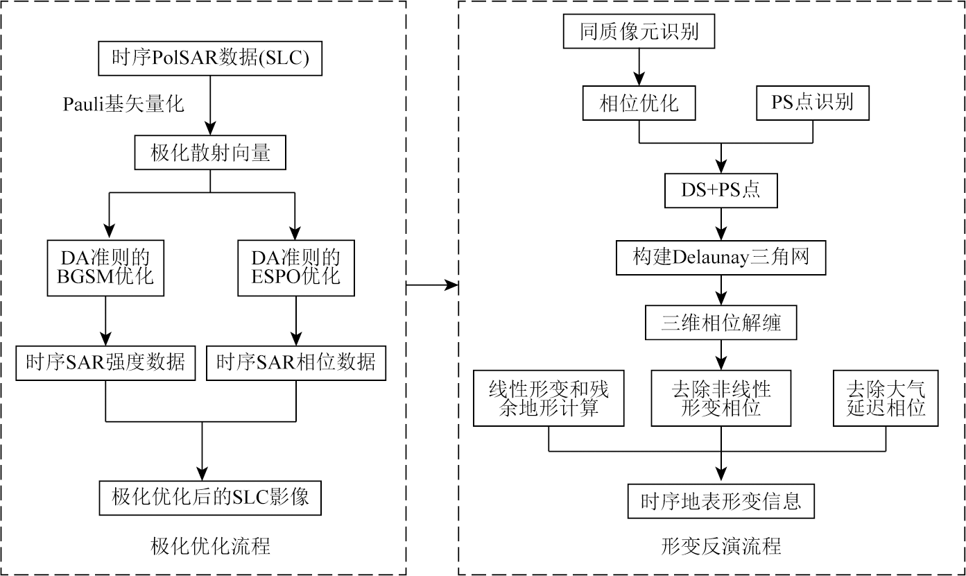
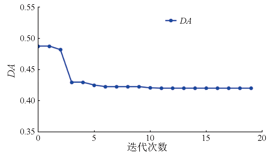
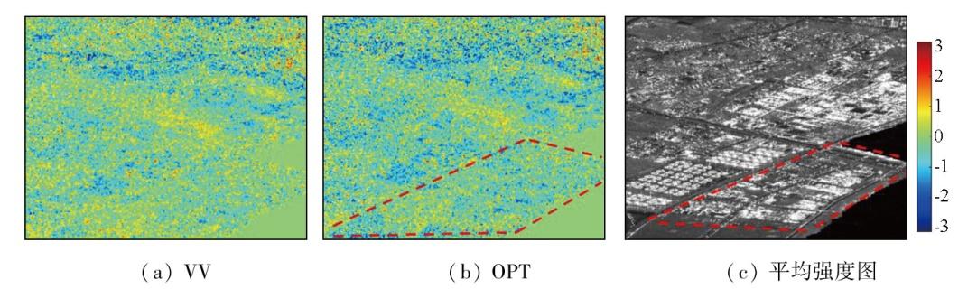
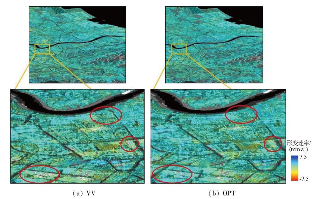
The spatial density and interferometric phase quality of high-quality monitoring points serve as key indicators for deformation monitoring using the time-series interferometric synthetic aperture radar (InSAR) technique. To further enhance the deformation monitoring ability of the InSAR technique for non-urban areas, this study proposed a polarization time-series InSAR method that takes into account distributed scatterers (DSs) using dual-polarization images from Sentinel-1. Specifically, polarization processing of the intensity and phase information of time-series SAR data was conducted using various methods based on the characteristics of DSs and taking the dispersion of amplitude (DA) as an indicator for the phase quality assessment. Then, surface deformation monitoring was performed using the data before and after optimization. This study carried out experiments on Ningbo City in Zhejiang Province using 40 scenes of dual-polarization (VV-VH) images from Sentinel-1. The results indicate that the proposed method can significantly increase the density of monitoring points and the interferometric phase quality. Compared to single polarization, the proposed method increased the quantities of persistent scatterers (PSs) and DSs by about 20% and 57.5%, respectively. Furthermore, the interferometric phase quality was also significantly improved, with the average coherence increasing by more than 15%. The proposed method allows for a more detailed reflection of regional deformations.
XUAN Jiabin , LI Ruren , FU Wenxue . Deformation monitoring using time-series InSAR with dual-polarization optimization[J]. Remote Sensing for Natural Resources, 2025 , 37(6) : 128 -137 . DOI: 10.6046/zrzyyg.2024346
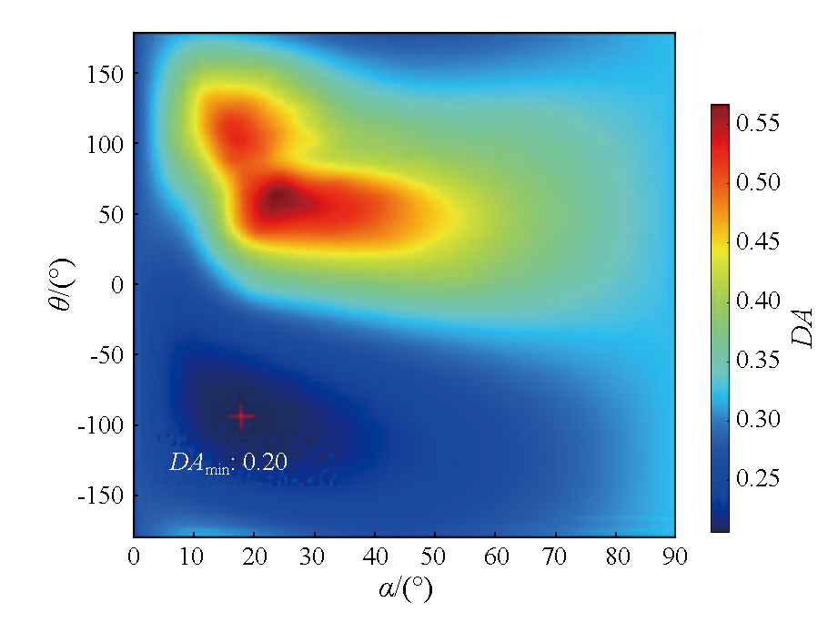
μ=ω†k,
表1 不同阈值下选取的PS点数量Tab.1 Number of PS points selected under different thresholds |
| 方法 | 指标范围 | |||
|---|---|---|---|---|
| 0~0.2 | 0~0.3 | 0~0.4 | 0~0.5 | |
| VV | 1 969 | 10 797 | 35 874 | 92 982 |
| OPT | 2 592 | 13 573 | 42 976 | 107 726 |
| (OPT-VV)/VV (↑) | 31.6% | 25.7% | 19.8% | 15.9% |
表2 干涉图质量评价结果Tab.2 Interferogram quality evaluation results |
| 干涉图 | 长时间基线(20230103—20220201) | 短时间基线(20230103—20221128) | ||||
|---|---|---|---|---|---|---|
| RPN | SPD | COH | RPN | SPD | COH | |
| VV | 925 008 | 6.2e+07 | 0. 289 | 872 105 | 6.5e+07 | 0. 322 |
| OPT | 822 700 (11.1%↓) | 5.9e+07 (4.9%↓) | 0. 322 (11.4%↑) | 754 483 (13.5%↓) | 6.1e+07 (6.2%↓) | 0. 371 (15.2%↑) |
| [1] |
|
| [2] |
|
| [3] |
|
| [4] |
|
| [5] |
|
| [6] |
|
| [7] |
安炳琪, 罗海滨, 丁海勇, 等. 基于SBAS-InSAR技术的西宁地表形变监测[J]. 遥感技术与应用, 2021, 36(4) :838-846.
|
| [8] |
|
| [9] |
|
| [10] |
|
| [11] |
何倩. 联合PS和DS的时序InSAR地表沉降监测方法研究[D]. 徐州: 中国矿业大学, 2022.
|
| [12] |
|
| [13] |
张路, 廖明生, 董杰, 等. 基于时间序列InSAR分析的西部山区滑坡灾害隐患早期识别——以四川丹巴为例[J]. 武汉大学学报(信息科学版), 2018, 43(12):2039-2049.
|
| [14] |
|
| [15] |
赵立峰. 基于DS-InSAR的矿区地表形变监测方法研究——以沛北矿区为例[D]. 徐州: 中国矿业大学, 2022.
|
| [16] |
|
| [17] |
|
| [18] |
|
| [19] |
|
| [20] |
|
| [21] |
赵峰, 张雷昕, 王腾, 等. 城市地表形变的双极化Sentinel-1数据极化时序InSAR技术监测[J]. 武汉大学学报(信息科学版), 2022, 47(9):1507-1514.
|
| [22] |
|
| [23] |
冯瀚, 赵峰, 汪云甲, 等. 双极化Sentinel-1数据极化时序InSAR技术地表形变监测——以上海市浦东机场为例[J]. 遥感学报, 2022, 26(12):2531-2541.
|
| [24] |
|
| [25] |
|
| [26] |
|
| [27] |
赵峰. 面向PSI技术的高质量SAR像元识别与干涉相位极化优化方法研究[J]. 地理与地理信息科学, 2020, 36(3):141.
|
| [28] |
|
| [29] |
桂阳归, 汪长城, 卢丽君, 等. 顾及极化最优的时序双极化InSAR形变监测方法[J]. 测绘科学, 2021, 46(12):75-82.
|
| [30] |
蒋弥, 丁晓利, 何秀凤, 等. 基于快速分布式目标探测的时序雷达干涉测量方法:以Lost Hills油藏区为例[J]. 地球物理学报, 2016, 59(10):3592-3603.
|
| [31] |
蒋弥, 丁晓利, 李志伟. 时序InSAR同质样本选取算法研究[J]. 地球物理学报, 2018, 61(12):4767-4776.
|
| [32] |
|
| [33] |
方海伦, 胡荣荣, 邱雨欣. 基于PS-InSAR技术的宁波市地面沉降监测研究[J]. 地质灾害与环境保护, 2023, 34(4):50-55.
|
| [34] |
|
| [35] |
|
| [36] |
温浩, 高峰, 胡在凰, 等. 地面沉降InSAR监测数据融合方法——以宁波市为例[J]. 测绘通报, 2024(s2):12-16.
|
| [37] |
马张烽, 蒋弥, 李桂华, 等. 空间网络对时序InSAR相位解缠的影响——以Delaunay与Dijkstra网络为例[J]. 测绘学报, 2022, 51(2):248-257.
|
/
| 〈 |
|
〉 |