
Remote Sensing for Natural Resources >
A precise coastline extraction method using surface moisture content and long-time-series remote sensing imagery
Received date: 2024-06-12
Revised date: 2024-08-04
Online published: 2026-06-03
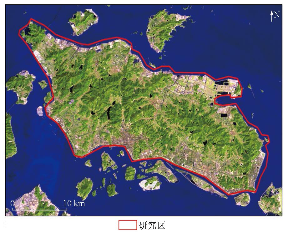
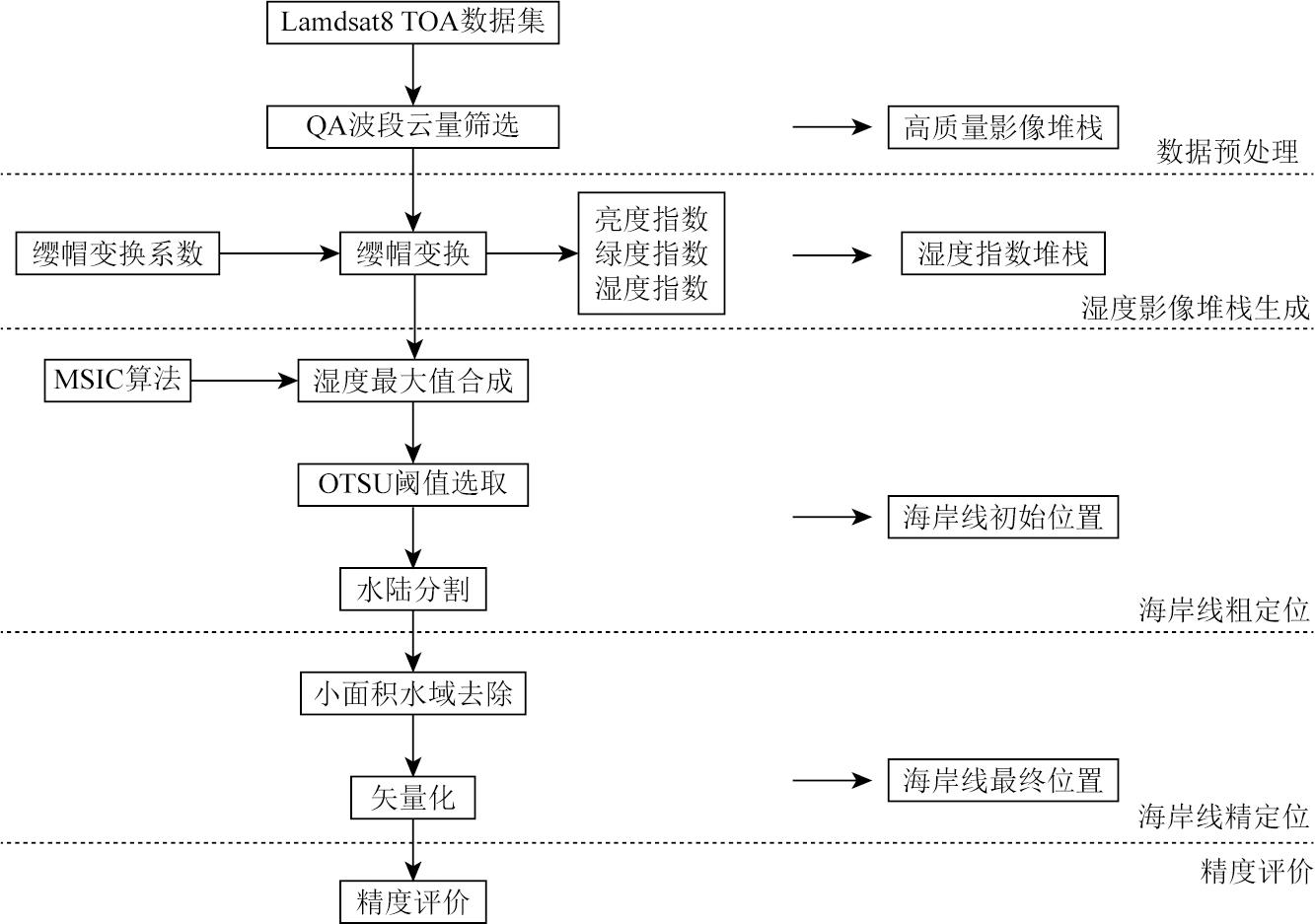
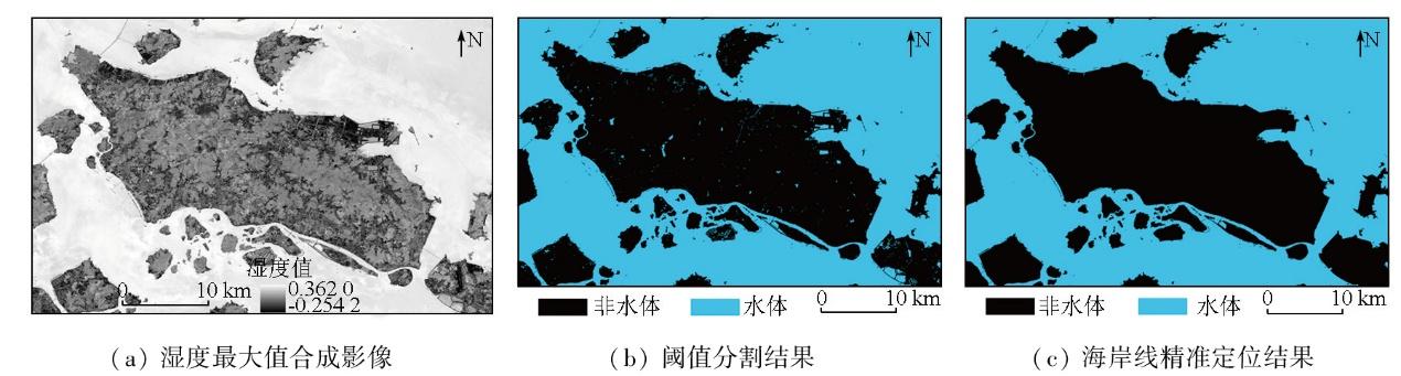
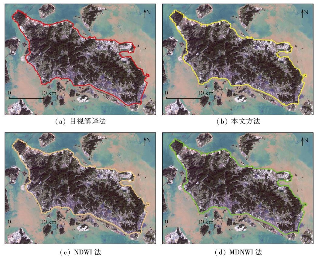
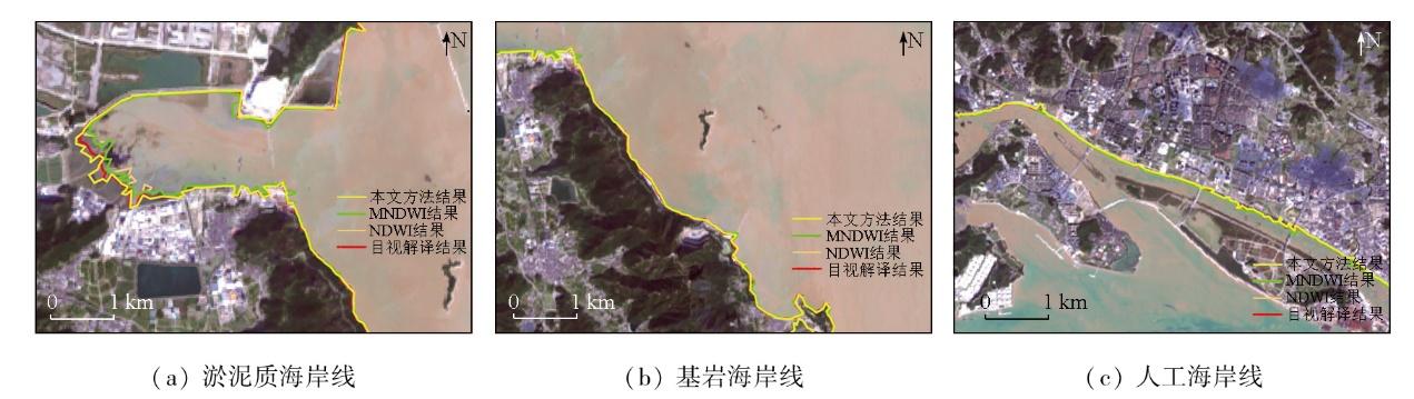
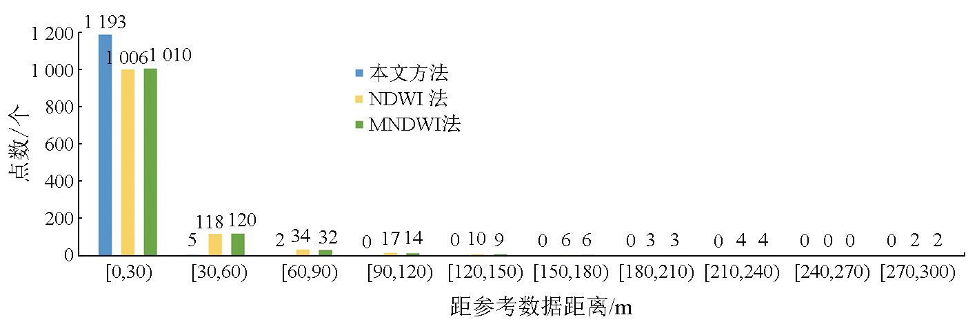
Coastlines serve as one of the most essential basic geographic elements. However,conventional methods generally face challenges in the accurate detection of their location,due to instantaneous remote sensing imaging and dynamic tidal phenomena. In response to this,this study developed a novel coastline extraction model that incorporates information on surface moisture content derived from long-time-series satellite remote sensing imagery. First,all available remote sensing images covering the study area during the target period were acquired to construct a high-quality remote sensing image stack. Second,the wetness components indicative of the surface moisture content were obtained using the tasseled cap transformation (TCT),from which a wetness index stack was constructed. Then,the wetness components were subjected to maximum value synthesis using the maximum spectral index composite (MSIC) algorithm,generating a maximum water surface composite image. Finally,the composite image was segmented using the OTSU algorithm to extract accurate coastline information. Validation experiments were conducted on Zhoushan Island using the Google Earth Engine (GEE) cloud computing platform and remote sensing imagery from the operational land imager (OLI) onboard the Landsat 8 satellite. The results indicate that the proposed model can precisely locate different types of coastlines with high spatial accuracy. Compared to visual interpretation,the model exhibited a mean deviation and a root mean square error (RMSE) of 3.42 m and 6.79 m,respectively,with 99.42% of validation points falling within one pixel width. This study provides an effective technical framework for high-accuracy coastline extraction,holding great significance for scientific management and sustainable development of coastal resources.
GONG Shaojun , CHEN Chao , FAN Jing . A precise coastline extraction method using surface moisture content and long-time-series remote sensing imagery[J]. Remote Sensing for Natural Resources, 2025 , 37(5) : 53 -61 . DOI: 10.6046/zrzyyg.2024198
表1 所用遥感影像及潮汐信息表Tab.1 Remote sensing images and tidal information |
| 序号 | 成像日期 | 行 | 列 | 云量/% | 潮汐信息(北京时间) | 序号 | 成像日期 | 行 | 列 | 云量/% | 潮汐信息(北京时间) | |||||
|---|---|---|---|---|---|---|---|---|---|---|---|---|---|---|---|---|
| 验潮站 | 高潮时刻 | 低潮时刻 | 验潮站 | 高潮时刻 | 低潮时刻 | |||||||||||
| 1 | 2022-01-03 | 117 | 39 | 1.05 | 沈家门 | 09:56 | 03:26 | 9 | 2022-03-24 | 117 | 40 | 13.50 | 岱山 | 13:54 | 08:54 | |
| 2 | 2022-01-03 | 117 | 40 | 3.25 | 沈家门 | 09:56 | 03:26 | 10 | 2022-04-09 | 117 | 40 | 8.55 | 岱山 | 15:04 | 10:17 | |
| 3 | 2022-01-19 | 117 | 40 | 0.35 | 沈家门 | 10:40 | 04:20 | 11 | 2022-05-02 | 118 | 39 | 11.24 | 岱山 | 11:12 | 05:46 | |
| 4 | 2022-02-27 | 118 | 39 | 0.08 | 沈家门 | 07:03 | 14:43 | 12 | 2022-08-22 | 118 | 39 | 9.55 | 岱山 | 06:28 | 12:32 | |
| 5 | 2022-03-08 | 117 | 39 | 0.05 | 沈家门 | 06:40 | 12:17 | 13 | 2022-10-02 | 117 | 39 | 2.63 | 岱山 | 14:52 | 08:16 | |
| 6 | 2022-03-08 | 117 | 40 | 0.07 | 沈家门 | 06:40 | 12:17 | 14 | 2022-10-02 | 117 | 40 | 3.88 | 岱山 | 14:52 | 08:16 | |
| 7 | 2022-03-15 | 118 | 39 | 0.15 | 沈家门 | 08:11 | 14:50 | 15 | 2022-11-10 | 118 | 39 | 11.81 | 岱山 | 11:30 | 05:21 | |
| 8 | 2022-03-24 | 117 | 39 | 0.03 | 沈家门 | 12:42 | 07:24 | 16 | 2022-11-26 | 118 | 39 | 6.21 | 岱山 | 12:08 | 05:44 | |
表2 Landsat8卫星反射率的缨帽变换系数Tab.2 Tasseled cap transformation coefficients for Landsat8 satellite reflectance |
| 缨帽变换后分量 | 波段 | |||||
|---|---|---|---|---|---|---|
| 蓝光 | 绿光 | 红光 | 近红外 | 短波红外1 | 短波红外2 | |
| 亮度指数 | -0.236 3 | -0.283 6 | -0.425 7 | 0.809 7 | 0.004 3 | -0.164 0 |
| 绿度指数 | 0.130 1 | 0.229 0 | 0.349 2 | 0.179 5 | -0.627 0 | -0.620 0 |
| 湿度指数 | -0.823 9 | 0.084 9 | 0.439 6 | -0.058 0 | 0.201 3 | -0.277 0 |
| TCT4 | -0.329 4 | 0.055 7 | 0.105 6 | 0.185 5 | -0.434 9 | 0.808 5 |
| TCT5 | 0.107 9 | -0.902 3 | 0.411 9 | 0.057 5 | -0.025 9 | 0.025 2 |
| TCT6 | 0.344 3 | 0.405 7 | 0.466 7 | 0.534 7 | 0.393 0 | 0.241 2 |
表3 海岸线长度及所围面积比较Tab.3 Comparisons in area and length of the coastline |
| 方法 | 面积/km2 | 长度/km | 面积误差/% | 长度误差/% |
|---|---|---|---|---|
| 目视解译 | 514.43 | 146.84 | — | — |
| 本文方法 | 513.68 | 150.51 | -0.14 | 2.50 |
| NDWI法 | 516.19 | 152.40 | 0.34 | 3.79 |
| MNDWI法 | 516.18 | 152.76 | 0.34 | 4.04 |
表4 距离平均值和RMSETab.4 Average and root mean square error |
| 方法 | 选取点数/个 | 距离平均值/m | RMSE/m |
|---|---|---|---|
| 本文方法 | 1 200 | 3.42 | 6.79 |
| NDWI法 | 1 200 | 18.40 | 30.50 |
| MNDWI法 | 1 200 | 18.03 | 30.12 |
| [1] |
|
| [2] |
|
| [3] |
侯西勇, 刘静, 宋洋, 等. 中国大陆海岸线开发利用的生态环境影响与政策建议[J]. 中国科学院院刊, 2016, 31(10):1143-1150.
|
| [4] |
|
| [5] |
刘宝银, 苏奋振. 中国海岸带与海岛遥感调查:原则方法系统[M]. 北京: 海洋出版社, 2005.
|
| [6] |
|
| [7] |
|
| [8] |
|
| [9] |
|
| [10] |
|
| [11] |
|
| [12] |
|
| [13] |
吴一全, 刘忠林. 遥感影像的海岸线自动提取方法研究进展[J]. 遥感学报, 2019, 23(4):582-602.
|
| [14] |
傅姣琪, 陈超, 郭碧云. 缨帽变换的遥感图像水边线信息提取方法[J]. 测绘科学, 2019, 44(5):177-183.
|
| [15] |
李清泉, 卢艺, 胡水波, 等. 海岸带地理环境遥感监测综述[J]. 遥感学报, 2016, 20(5):1216-1229.
|
| [16] |
|
| [17] |
|
| [18] |
|
| [19] |
|
| [20] |
|
| [21] |
|
| [22] |
|
| [23] |
陈云浩, 冯通, 史培军, 等. 基于面向对象和规则的遥感影像分类研究[J]. 武汉大学学报(信息科学版), 2006, 31(4):316-320.
|
| [24] |
詹雅婷, 朱利, 孙永华, 等. 海岸线遥感光谱角度—距离相似度生长模型自动化提取[J]. 遥感学报, 2017, 21(3):458-469.
|
| [25] |
|
| [26] |
|
| [27] |
|
| [28] |
|
| [29] |
|
| [30] |
|
| [31] |
|
| [32] |
|
| [33] |
|
| [34] |
|
| [35] |
|
| [36] |
|
| [37] |
闫柏琨, 甘甫平, 印萍, 等. 1989—2021年中国大陆海岸带潮滩、海岸线、养殖水体遥感观测[J]. 自然资源遥感, 2023, 35(3):53-63.doi:10.6046/zrzyyg.2022471.
|
| [38] |
|
| [39] |
|
| [40] |
程丽娜, 钟才荣, 李晓燕, 等. Sentinel-2密集时间序列数据和Google Earth Engine的潮间带湿地快速自动分类[J]. 遥感学报, 2022, 26(2):348-357.
|
/
| 〈 |
|
〉 |