
Remote Sensing for Natural Resources >
GIS-based analysis of dynamic changes and driving forces for natural lakes in Anhui Province
Received date: 2025-02-26
Revised date: 2025-04-18
Online published: 2026-06-03
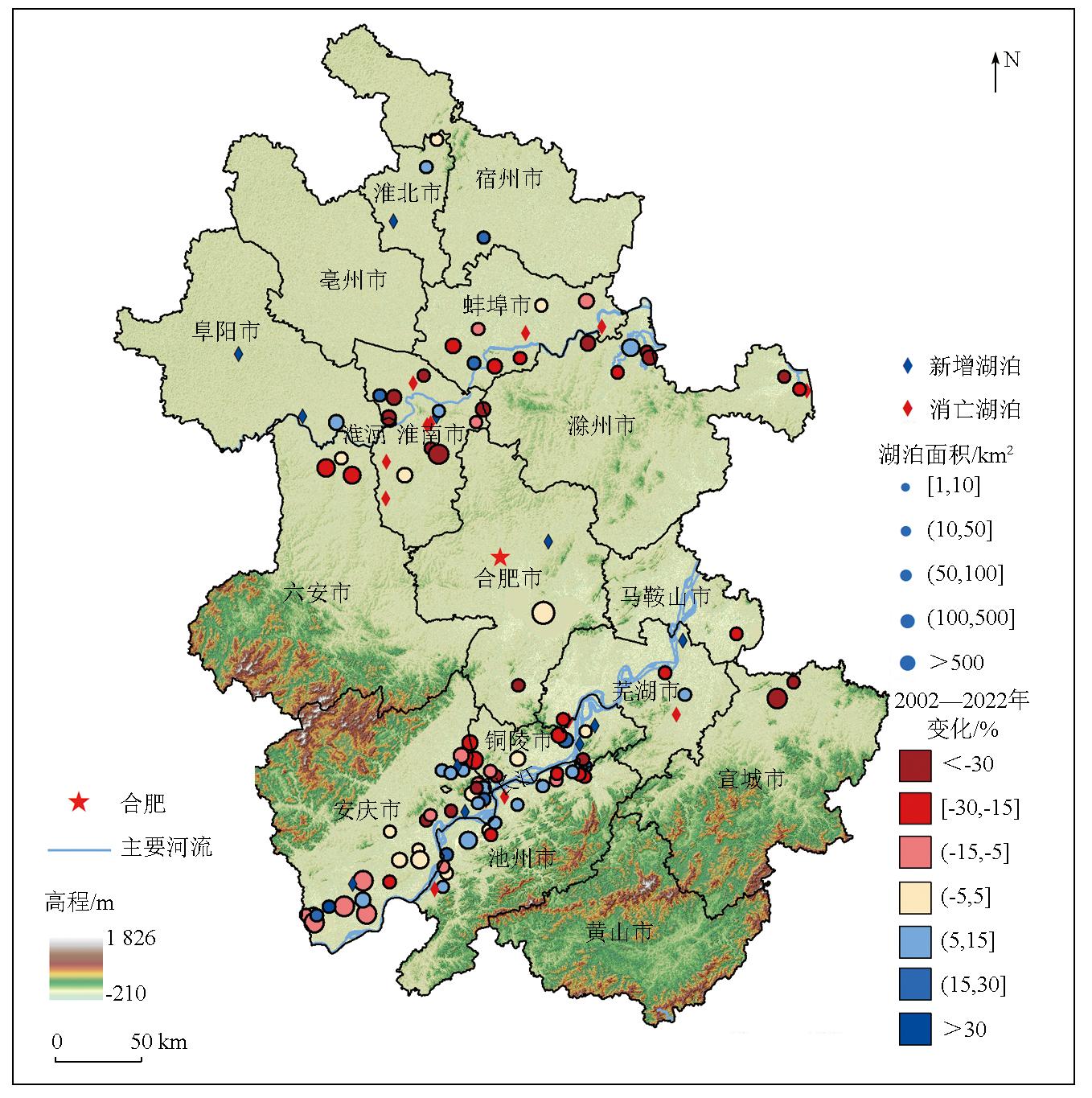
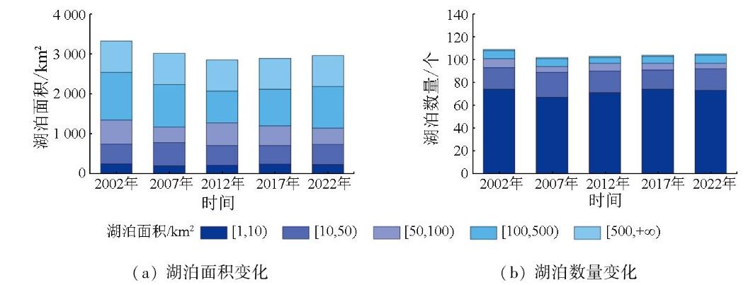
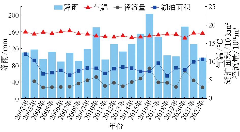
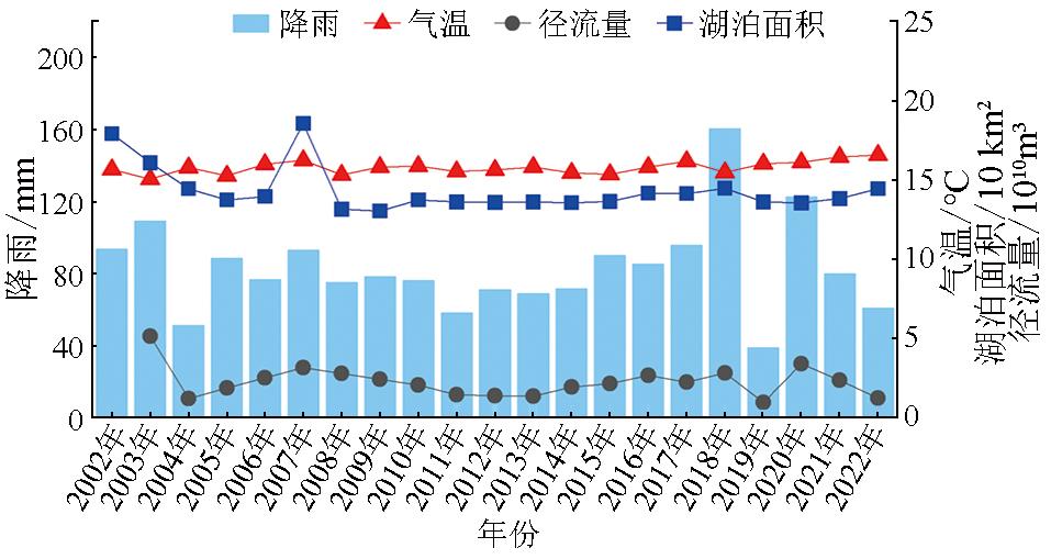
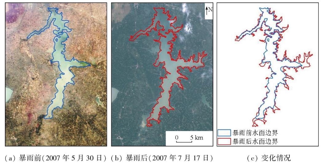
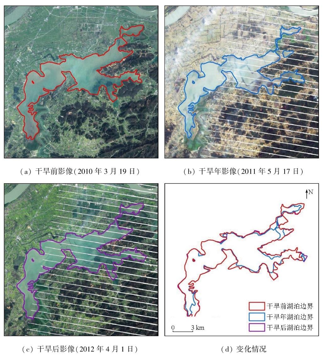
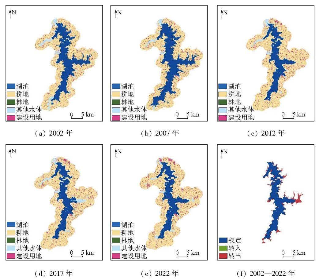
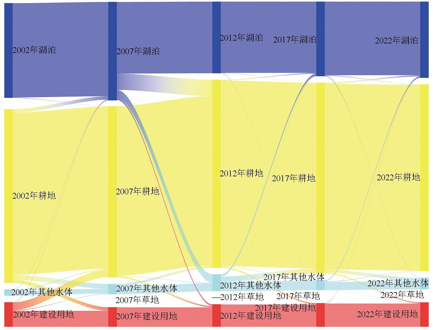
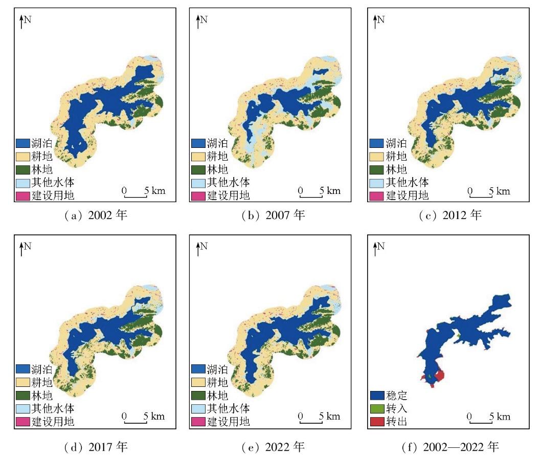
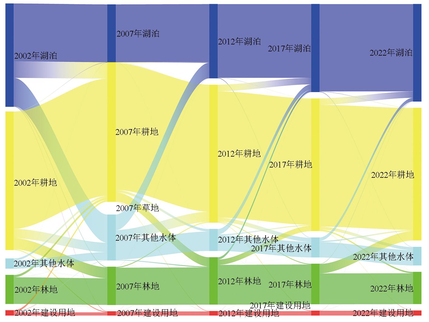
Natural lakes,as a precious natural resource in Anhui Province,are defined as large water bodies formed by natural water accumulation in surface depressions. Different from artificial water bodies such as reservoirs and ponds,they are formed and evolved under the control of geological,climatic,and hydrological conditions. Moreover,characterized by relatively stable forms and ecosystems,they play important roles in regional ecological balance,economic development,and socio-cultural activities. Therefore,investigating their spatiotemporal changes and driving forces is highly significant for the protection of natural lakes in Anhui Province. This study collected data from the Thematic Mapper (TM) onboard the Landsat-5 satellite and the Operational Land Imager onboard the Landsat-8 satellite. Then,the natural lakes in Anhui Province were extracted from these data using a human-computer interaction method. This study investigated spatiotemporal changes of the lakes using the dynamic degree and land use transfer matrix. The driving factors of the changes were examined from two aspects:natural factors and social factors. From 2002 to 2022,the natural lakes in Anhui Province showed a phased change in both area and number,characterized by an initial decrease followed by an increase. In terms of lake area,the total area of the lakes decreased by 366.5 km2. Specifically,from 2002 to 2012,the lake area decreased rapidly,reaching its lowest value of 2850.12 km2 in 2012. From 2012 to 2022,the area gradually recovered,rebounding to 2960.97 km2 in 2022. In terms of the lake number,there was a cumulative reduction of four lakes over the period. Specifically,the period from 2002 to 2007 saw a rapid decline,with an average annual decrease of 1.4 lakes. From 2007 to 2022,the number gradually rebounded,with an average annual increase of 0.2 lakes,reaching a total of 105 lakes in 2022. The changes in land use around typical lakes predominantly involved the conversion to arable land and other water bodies. In Anhui Province,the natural lake areas were influenced by both natural and social factors. The decreased runoff of the Huaihe River resulted in a decrease in inflow into the lakes,which serves as a key natural factor contributing to the reduction of the natural lake area in Anhui Province. Human activities and land use changes around the lakes are identified as important social factors for the reduction of the lake area.
Key words: Anhui Province; natural lake; remote sensing; dynamic change; driving force analysis
HE Weirong , HUO Runbin , LI Donghui , ZHANG Fengshan , WANG Xinfeng . GIS-based analysis of dynamic changes and driving forces for natural lakes in Anhui Province[J]. Remote Sensing for Natural Resources, 2025 , 37(5) : 32 -43 . DOI: 10.6046/zrzyyg.2025043
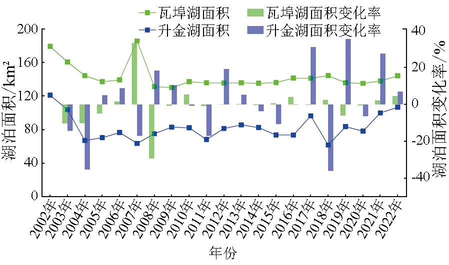
表1 2002—2022年典型湖泊土地利用类型变化面积Tab.1 Changes of land use types of typical lakes in 2002 to 2022 (km2) |
| 湖泊 名称 | 变化情况 | 2002— 2022年 | 2002— 2007年 | 2007— 2012年 | 2012— 2017年 | 2017— 2022年 |
|---|---|---|---|---|---|---|
| 瓦 埠 湖 | 耕地→湖泊 | 0.85 | 6.47 | 0.05 | 1.60 | 2.16 |
| 湖泊→耕地 | 25.67 | 0.77 | 30.76 | 0.33 | 1.01 | |
| 其他水体→湖泊 | 0.31 | 0.86 | 0.04 | 4.47 | 2.34 | |
| 湖泊→其他水体 | 7.74 | 0.00 | 16.06 | 0.41 | 0.79 | |
| 建设用地→湖泊 | 0.14 | 0.51 | 0.02 | 0.31 | 0.43 | |
| 湖泊→建设用地 | 2.10 | 0.01 | 3.17 | 0.04 | 0.12 | |
| 升 金 湖 | 耕地→湖泊 | 1.71 | 0.42 | 0.89 | 7.21 | 6.98 |
| 湖泊→耕地 | 5.55 | 18.13 | 0.06 | 0.14 | 0.29 | |
| 林地→湖泊 | 0.11 | 0.10 | 0.06 | 2.47 | 0.23 | |
| 湖泊→林地 | 0.12 | 0.42 | 0.01 | 0.03 | 0.04 | |
| 其他水体→湖泊 | 0.32 | 0.07 | 16.96 | 5.91 | 3.70 | |
| 湖泊→其他水体 | 2.37 | 30.90 | 0.11 | 0.46 | 0.35 | |
| 建设用地→湖泊 | 0.08 | 0.02 | 0.07 | 0.10 | 0.11 | |
| 湖泊→建设用地 | 0.16 | 0.32 | - | 0.02 | 0.04 |
表2 安徽省湖泊面积与驱动因子相关系数Tab.2 Correlation coefficient between lake area and driving factors in Anhui Province |
| 因子 | 相关系数 |
|---|---|
| 降雨量 | 0.321 |
| 气温 | 0.528 |
| 长江径流量 | 0.291 |
| 淮河径流量 | 0.922*① |
| 人口 | -0.494 |
| GDP | -0.566 |
| 耕地面积 | -0.458 |
①*表示p<0.05。 |
| [1] |
杨桂山, 马荣华, 张路, 等. 中国湖泊现状及面临的重大问题与保护策略[J]. 湖泊科学, 2010, 22(6):799-810.
|
| [2] |
王苏民, 窦鸿身. 中国湖泊志[M]. 北京: 科学出版社, 1998.
|
| [3] |
马荣华, 杨桂山, 段洪涛, 等. 中国湖泊的数量、面积与空间分布[J]. 中国科学:地球科学, 2011, 41(3):394-401.
|
| [4] |
张闻松, 宋春桥. 中国湖泊分布与变化:全国尺度遥感监测研究进展与新编目[J]. 遥感学报, 2022, 26(1):92-103.
|
| [5] |
刘吉峰, 吴怀河, 宋伟. 中国湖泊水资源现状与演变分析[J]. 黄河水利职业技术学院学报, 2008, 20(1):1-4.
|
| [6] |
祁家禹. 安徽省水资源现状及保护利用对策[J]. 现代农业科技, 2011(21):273.
|
| [7] |
宋昊明, 汪振宁, 顾雯. 安徽省淮河流域湖泊保护探讨[J]. 水资源开发与管理, 2021, 7(7):41-43,32.
|
| [8] |
|
| [9] |
|
| [10] |
|
| [11] |
|
| [12] |
白洁, 陈曦, 李均力, 等. 1975—2007年中亚干旱区内陆湖泊面积变化遥感分析[J]. 湖泊科学, 2011, 23(1):80-88.
|
| [13] |
王云惠. 基于卫星遥感影像的近30年来中国主要湖泊面积变化研究[D]. 昆明: 云南师范大学, 2022.
|
| [14] |
|
| [15] |
段俊斌, 彭鹏, 杨道堃. 基于RS的安庆市沿江湿地50多年来变迁及驱动力分析[J]. 安徽地质, 2021, 31(4):352-357.
|
| [16] |
王春霞. 基于遥感影像的云贵高原湖泊提取及动态变化分析[D]. 贵阳: 贵州大学, 2022.
|
| [17] |
李宁, 刘吉平, 王宗明. 2000—2010年东北地区湖泊动态变化及驱动力分析[J]. 湖泊科学, 2014, 26(4):545-551.
|
| [18] |
王冬梅, 陈丽, 梁文广, 等. 太湖流域典型湖泊演变特性及驱动力分析[J]. 中国农村水利水电, 2023(6):107-114.
|
| [19] |
|
| [20] |
周迎秋. 基于遥感的巢湖流域环境变化研究[D]. 芜湖: 安徽师范大学, 2005.
|
| [21] |
张毅, 孔祥德, 邓宏兵, 等. 近百年湖北省湖泊演变特征研究[J]. 湿地科学, 2010, 8(1):15-20.
|
| [22] |
|
| [23] |
王威, 隋兵, 林南, 等. 基于Landsat遥感数据的洞庭湖面积变化研究[J]. 气象科技进展, 2020, 10(3):128-132.
|
| [24] |
徐娜, 贾建华, 罗菊花, 等. 江苏省湖泊遥感监测及10年动态变化分析[J]. 长江流域资源与环境, 2014, 23(4):468-474.
|
| [25] |
|
| [26] |
赵世雄. 淮河入洪泽湖段岸滩及湖区围垦演变影响研究[D]. 天津大学, 2020.
|
| [27] |
王秀兰, 包玉海. 土地利用动态变化研究方法探讨[J]. 地理科学进展, 1999, 18(1):81-87.
|
| [28] |
朱会义, 李秀彬. 关于区域土地利用变化指数模型方法的讨论[J]. 地理学报, 2003, 58(5):643-650.
|
| [29] |
李荣华, 姜英, 吕炜, 等. 变量间的相关系数及其SPSS中计算[J]. 教育现代化, 2020, 7(21):107-108.
|
| [30] |
方金琪. 我国历史时期的湖泊围垦与湖泊退缩[J]. 地理环境研究, 1989, 1(1):71-78.
|
| [31] |
姜鲁光, 封志明, 于秀波, 等. 退田还湖后鄱阳湖区洪水调蓄功能的多情景模拟[J]. 资源科学, 2010, 32(5):817-823.
|
| [32] |
梁益同, 夏智宏, 文雄飞, 等. 基于卫星遥感的40年洪湖水面变化及驱动力分析[J]. 气象科技进展, 2018, 8(5):85-90.
|
| [33] |
蒋卫国, 李京, 王文杰, 等. 基于遥感与GIS的辽河三角洲湿地资源变化及驱动力分析[J]. 国土资源遥感, 2005, 17(3):62-65,101.doi:10.6046/gtzyyg.2005.03.15.
|
| [34] |
何思聪, 董恒, 张城芳. 1994—2015年武汉城市圈湖泊演变规律及驱动力分析[J]. 生态与农村环境学报, 2020, 36(10):1260-1267.
|
| [35] |
王国平, 张玉霞. 水利工程对向海湿地水文与生态的影响[J]. 资源科学, 2002, 24(3):26-30.
|
/
| 〈 |
|
〉 |
