
Remote Sensing for Natural Resources >
Estimation and spatial pattern analysis of forest above-ground biomass based on Sentinel-2 and GEDI data
Received date: 2024-09-20
Revised date: 2025-01-10
Online published: 2026-06-03
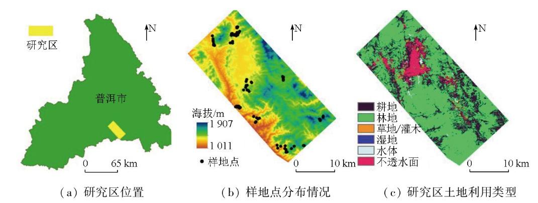
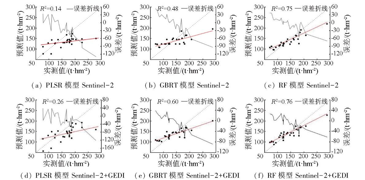
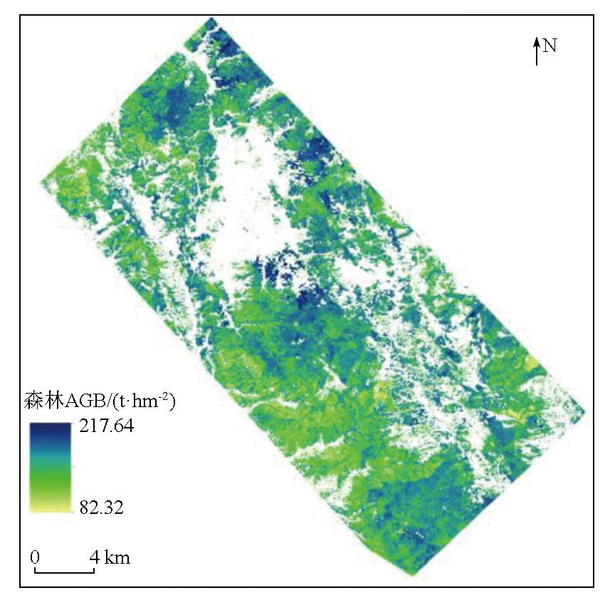
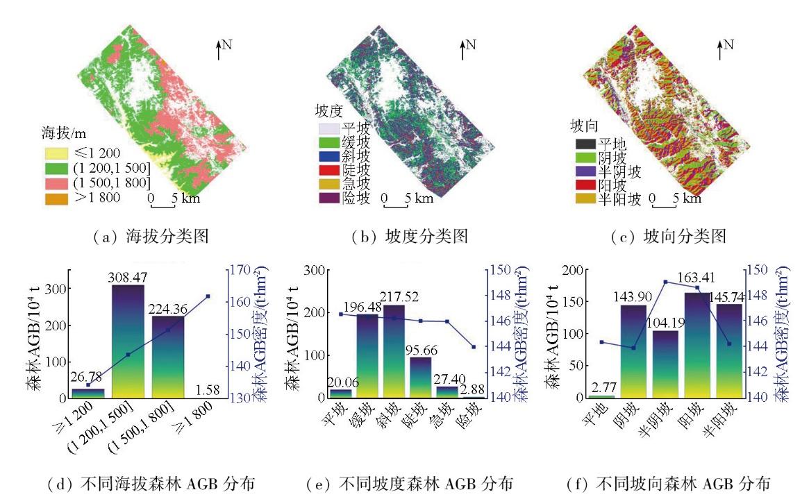
Forest above-ground biomass (AGB) is recognized as an important indicator of forest productivity. Rapid and accurate estimation of forest AGB is crucial for sustainable forest management and carbon cycle research. Based on spaceborne light detection and ranging (LiDAR) data from the global ecosystem dynamic investigation (GEDI) and Sentinel-2 optical data,this study extracted GEDI L2B,Sentinel-2 remote sensing features,and topographic factors (elevation,aspect,and slope) in the study area. Among them,variables were determined through Pearson correlation analysis. Then,this study constructed the partial least squares regression (PLSR),gradient boosting regression tree (GBRT),and random forest (RF) models for forest AGB inversion. Consequently,this study estimated these models’ potential for forest AGB estimation and analyzed the spatial distribution differences of forest AGB. The results indicate that the estimation using multi-source data consistently outperformed that using single-source data. Among them,the RF model based on GEDI and Sentinel-2 data exhibited the best performance (R2=0.76,root mean square error (RMSE)=23.02 t/hm2),followed by the GBRT model,while the PLSR model performed the worst (R2=0.26). In terms of spatial distribution,within the elevation range of 1 200~1 800 m,forest AGB density increased with elevation. Slope variation had little effect on forest AGB density,but a pronounced decrease in AGB density was observed on steep slopes. Aspect analysis showed that semi-shaded and sunny slopes exhibited high forest AGB density,while shaded and semi-sunny slopes presented similar values. Slope-aspect interaction analysis revealed that sunny and semi-sunny slopes displayed the highest total forest AGB on gentle and moderate slopes,respectively. In contrast,forest AGB significantly decreased across all orientations on flat and steep slopes,with a more significant decline observed on shaded and semi-shaded slopes. These findings provide a scientific basis for formulating forest protection and cultivation policies at the provincial level.
WANG Lu , JI Yongjie , DONG Wenquan , ZHANG Wangfei . Estimation and spatial pattern analysis of forest above-ground biomass based on Sentinel-2 and GEDI data[J]. Remote Sensing for Natural Resources, 2025 , 37(5) : 224 -232 . DOI: 10.6046/zrzyyg.2024304
表1 GEDI L2B数据特征信息Tab.1 Parameter information of GEDI L2B data |
| 特征名称 | 物理含义 | 特征名称 | 物理含义 |
|---|---|---|---|
| sensitivity | 灵敏度 | pgap_theta | 森林冠层间隙率 |
| modis_treecover | 根据MODIS数据得出的植被百分比 | modis_nonvegetated | 根据MODIS数据得出的非植被百分比 |
| pgap_theta_error | 森林冠层间隙率的误差 | landsat_treecover | Landsat树冠覆盖率 |
| rv | 波形中植被分量的积分 | height_lastbin | 相对森林冠层间隙误差的地面高度 |
| rh100 | 接收波形信号的起始点离地面的高度 | fhd_normal | 叶片高度多样性指数 |
| rg | 波形中地面分量的积分 | digital_elevation_model | 数字高程模型高于WGS84椭圆形的高度 |
| pai | 植被总面积指数 | cover | 树冠总覆盖率 |
| shot number | 激光点号 | degrade_flag | 指向或定位信息降级状态的标志 |
| lat_lowestmode | 最低模式中心的纬度 | lon_lowestmode | 最低模式中心的经度 |
| quality_flag | 标记以简化最有用数据的选择 | leaf_off_flag | 指示观察是否在落叶林条件下记录 |
| beam | 激光器强弱指示 |
表2 Sentinel-2数据特征信息Tab.2 Features information of Sentinel-2 data |
| 类型 | 特征名称 |
|---|---|
| 原始波段 | B2,B3,B4,B5,B6,B7,B8,B11 |
| 植被指数 | 归一化植被指数、差值植被指数、比值植被指数、变换的归一化差异植被指数、绿色标准化差异植被指数、归一化差异指数、红边拐点指数、Sentinel-2红边位置指数 |
| 纹理特征 | 均值、方差、熵、对比度、同质性、相关性、非相似性、角二阶矩 |
| 缨帽变换特征 | 亮度、绿度、湿度 |
| 主成分分析 | PCA1,PCA2,PCA3 |
表3 森林AGB模型估测精度Tab.3 Estimation accuracy of forest AGB model |
| 数据源 | 模型 | R2 | RMSE/(t·hm-2) |
|---|---|---|---|
| Sentinel-2 | RF | 0.73 | 24.34 |
| GBRT | 0.48 | 33.72 | |
| PLSR | 0.14 | 40.36 | |
| Sentinel-2+GEDI | RF | 0.76 | 23.02 |
| GBRT | 0.60 | 29.35 | |
| PLSR | 0.26 | 37.56 |
表4 坡度-坡向交互作用下的森林AGB分布情况Tab.4 Forest AGB distribution under the interaction of slope and aspect |
| 坡度 | 坡向 | 森林 AGB/104 t | 坡度 | 坡向 | 森林 AGB/104 t |
|---|---|---|---|---|---|
| 平坡 | 平地 | 0.62 | 陡坡 | 平地 | 0.29 |
| 阴坡 | 3.97 | 阴坡 | 27.26 | ||
| 半阴坡 | 4.61 | 半阴坡 | 18.44 | ||
| 阳坡 | 5.16 | 阳坡 | 27.25 | ||
| 半阳坡 | 5.71 | 半阳坡 | 22.44 | ||
| 缓坡 | 平地 | 0.97 | 急坡 | 平地 | 0.11 |
| 阴坡 | 43.72 | 阴坡 | 8.73 | ||
| 半阴坡 | 35.79 | 半阴坡 | 5.85 | ||
| 阳坡 | 57.95 | 阳坡 | 7.47 | ||
| 半阳坡 | 58.08 | 半阳坡 | 5.24 | ||
| 斜坡 | 平地 | 0.76 | 险坡 | 平地 | 0.01 |
| 阴坡 | 59.37 | 阴坡 | 0.95 | ||
| 半阴坡 | 38.70 | 半阴坡 | 0.80 | ||
| 阳坡 | 64.98 | 阳坡 | 0.60 | ||
| 半阳坡 | 53.76 | 半阳坡 | 0.51 |
| [1] |
|
| [2] |
薛春泉, 徐期瑚, 林丽平, 等. 基于异速生长和理论生长方程的广东省木荷生物量动态预测[J]. 林业科学, 2019, 55(7):86-94.
|
| [3] |
闻馨, 刘凯, 曹晶晶, 等. 基于森林冠层高度和异速生长方程的中国红树林地上生物量估算[J]. 热带地理, 2023, 43(1):1-11.
|
| [4] |
|
| [5] |
|
| [6] |
李旺, 牛铮, 王成, 等. 机载LiDAR数据估算样地和单木尺度森林地上生物量[J]. 遥感学报, 2015, 19(4):669-679.
|
| [7] |
|
| [8] |
|
| [9] |
田国帅, 周小成, 郝优壮, 等. 结合修正后的全球生态系统动态调查冠层高度的森林地上生物量模型优化——以福建省为例[J]. 生态学报, 2024, 44(16):7264-7277.
|
| [10] |
|
| [11] |
|
| [12] |
|
| [13] |
|
| [14] |
胥辉, 张会儒. 林木生物量模型研究[M]. 昆明: 云南科技出版社, 2002.
|
| [15] |
韩明辉, 邢艳秋, 李国元, 等. GEDI不同算法组数据反演森林最大冠层高度和生物量精度比较[J]. 中南林业科技大学学报, 2022, 42(10):72-82.
|
| [16] |
|
| [17] |
刘霜. 基于Sentinel-1/2的重庆市南川区森林生物量估算研究[D]. 成都: 成都理工大学, 2020.
|
| [18] |
|
| [19] |
姜丰, 朱家玲, 胡开永, 等. Pearson相关系数评价ORC系统蒸发器特性的应用研究[J]. 太阳能学报, 2019, 40(10):2732-2738.
|
| [20] |
贺鹏, 张会儒, 雷相东, 等. 基于地统计学的森林地上生物量估计[J]. 林业科学, 2013, 49(5):101-109.
|
| [21] |
|
| [22] |
|
| [23] |
罗绍龙, 舒清态, 余金格, 等. 基于序贯高斯条件模拟的GEDI数据联合Landsat8反演森林地上生物量[J]. 林业科学研究, 2024, 37(3):49-60.
|
| [24] |
|
| [25] |
|
| [26] |
|
| [27] |
|
| [28] |
|
| [29] |
刘兴良, 史作民, 杨冬生, 等. 山地植物群落生物多样性与生物生产力海拔梯度变化研究进展[J]. 世界林业研究, 2005, 18(4):27-34.
|
| [30] |
|
| [31] |
窦佳慧, 梁宇, 怀保娟, 等. 不同地形条件下青藏高原森林生产力和碳收支动态[J]. 生态学杂志, 2024, 43(6):1521-1530.
|
/
| 〈 |
|
〉 |