
Remote Sensing for Natural Resources >
Altered mineral mapping and characteristic analysis in Qianhongquan Area,Beishan,Gansu Province,based on hyperspectral data from the ZY-1 02D satellite
Received date: 2024-09-06
Revised date: 2025-03-24
Online published: 2026-06-03
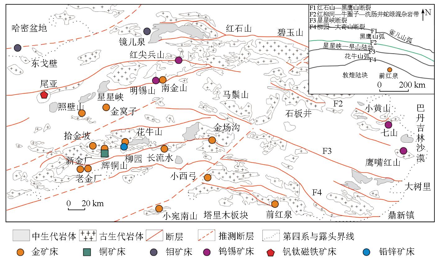
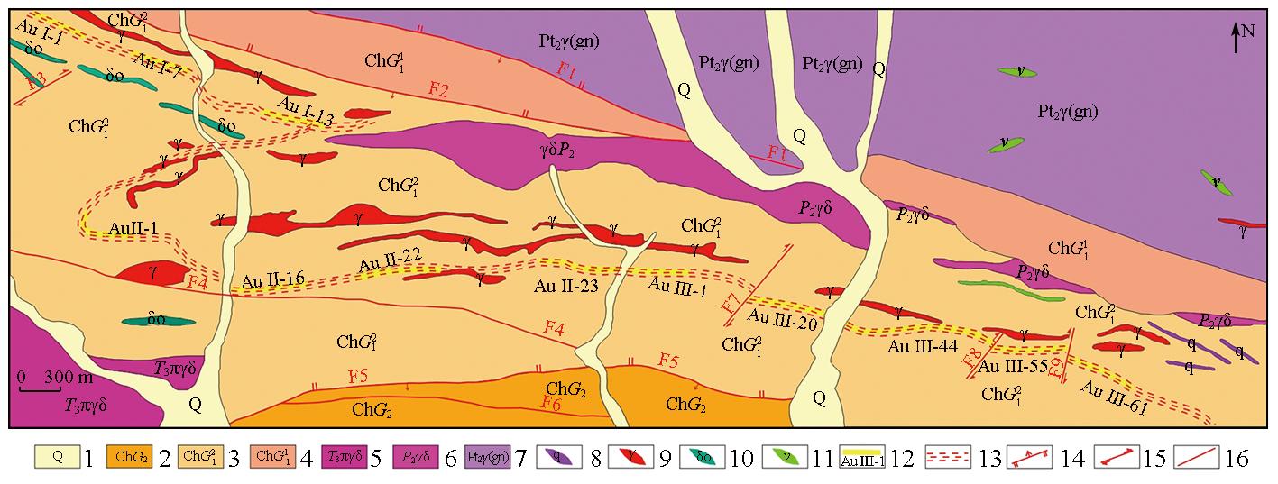
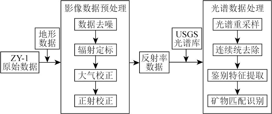
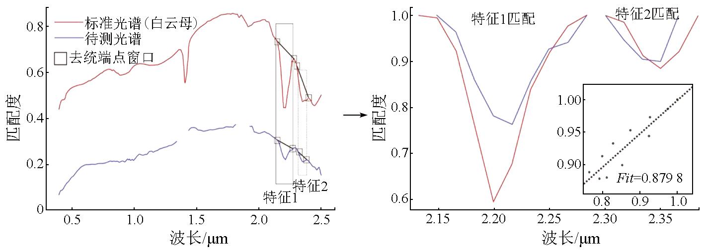
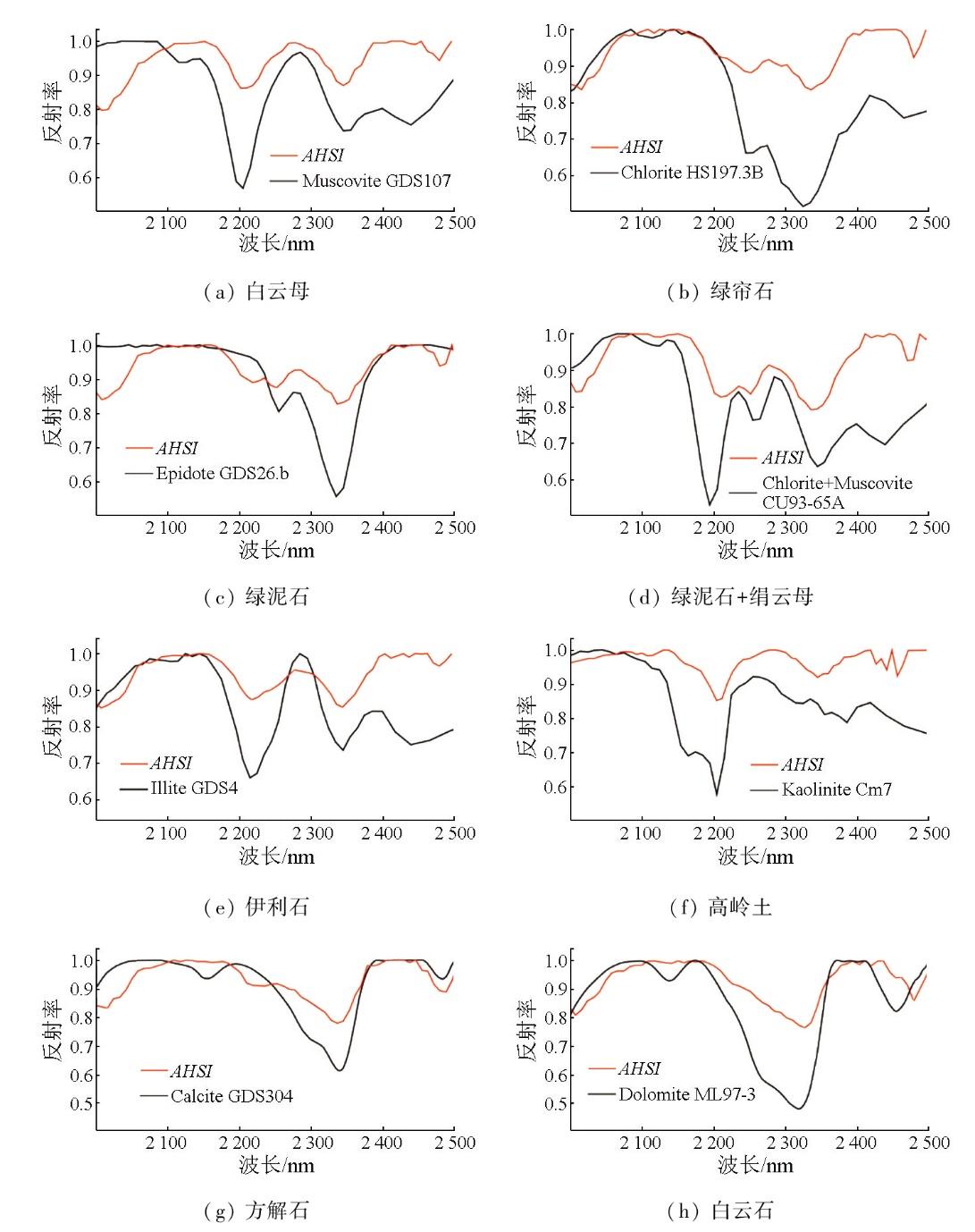
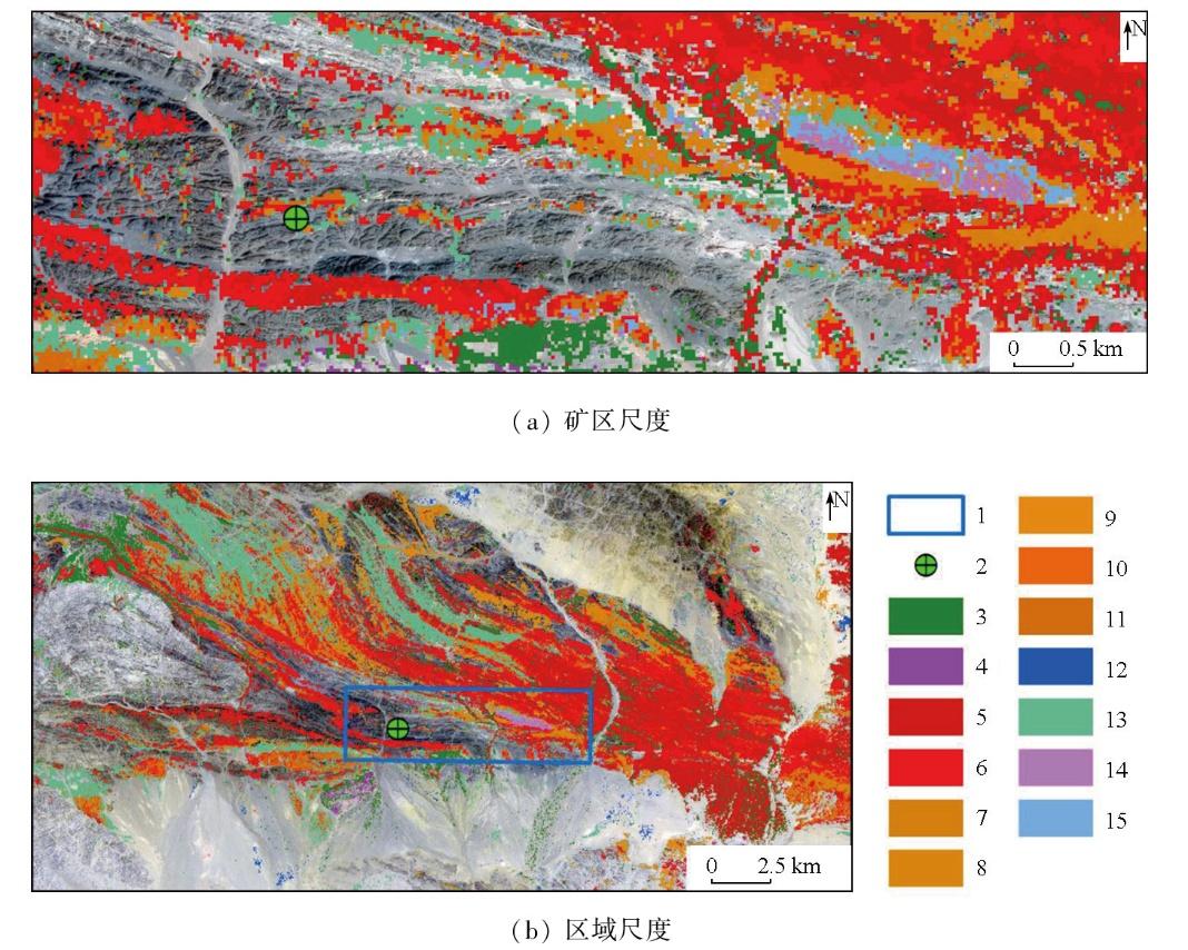
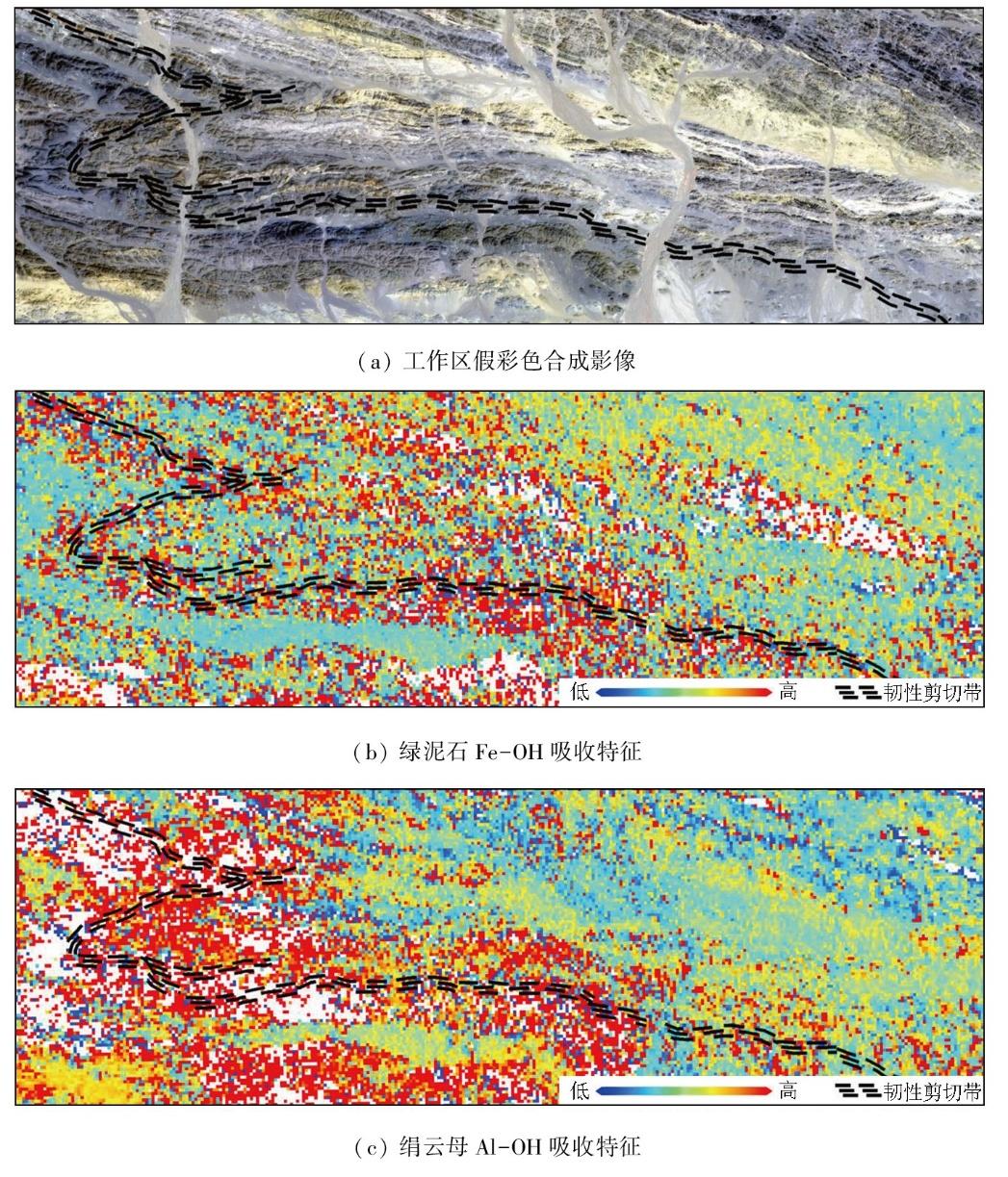
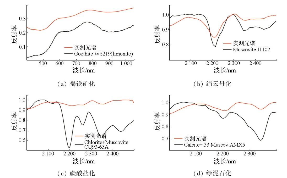
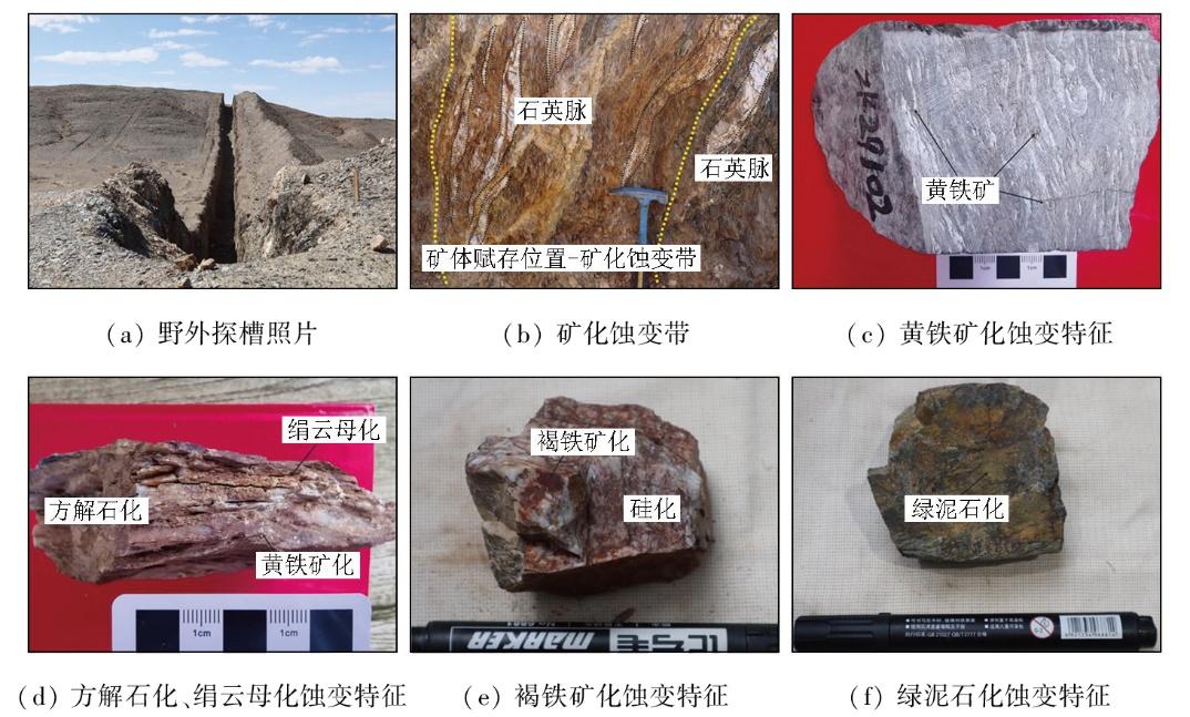
Hyperspectral remote sensing (HRS) technology,with its high spectral resolution and extensive spectral coverage,demonstrates significant potential in geological prospecting. Focusing on the Qianhongquan gold deposit in the Beishan orogenic belt,Gansu Province,this study conducted altered mineral mapping and component analysis,using HRS data from the AHSI sensor on the ZY-1 02D satellite and the self-developed hyperspectral mineral mapping technique,GeoAHSI,revealing their spatial distribution characteristics. Besides,ground-based spectral measurements were conducted on typical profiles to validate the spectral data,thereby assessing the reliability of the hyperspectral mineral mapping results. The results indicate that the primary altered minerals in the Qianhongquan gold deposit and its surrounding rocks include sericites (low-aluminum,medium-aluminum,high-aluminum,and iron-rich muscovites),calcites,dolomites,epidotes,and chlorites. Their distribution is closely related to ductile shear zones,with the distribution of sericites,chlorites,and epidotes being particularly significant within these zones. This spatial correlation provides critical indicators for regional prospecting. Additionally,it was observed that the 2 200 nm absorption feature of sericites and the 2 250 nm absorption feature of chlorites exhibit marked enrichment in silicon (Si) and iron (Fe) around ore bodies,which is closely correlated to the chemical compositions of the minerals. By enhancing the identification of weak spectral features,this study successfully applied HRS technology to mineral identification and spatial distribution analysis. These findings provide a scientific basis for further exploration of the Qianhongquan gold deposit and offer valuable references and guidance for the application of HRS in similar deposits.
HE Haiyang , LI Shijie , QIN Haoyang , LIU Xiaoyu , WANG Siqi , SUN Xu . Altered mineral mapping and characteristic analysis in Qianhongquan Area,Beishan,Gansu Province,based on hyperspectral data from the ZY-1 02D satellite[J]. Remote Sensing for Natural Resources, 2025 , 37(5) : 195 -205 . DOI: 10.6046/zrzyyg.2024293
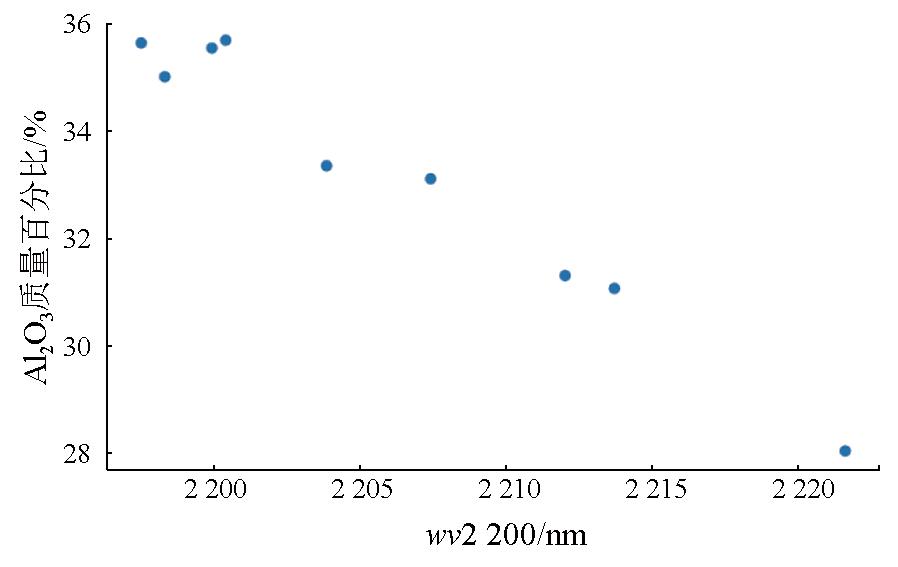
表2 USGS光谱库绢云母样本Tab.2 Muscovite samples from the USGS spectral library |
| 样本ID | 光谱仪 | wv2 200/μm | Al2O3质量百分比/% |
|---|---|---|---|
| GDS114 | BECK | 2.207 | 33.09 |
| GDS116 | BECK | 2.214 | 31.06 |
| GDS111 | BECK | 2.222 | 28.03 |
| GDS113 | NIC4 | 2.197 | 35.64 |
| GDS117 | NIC4 | 2.200 | 35.54 |
| GDS118 | BECK | 2.212 | 31.31 |
| GDS108 | NIC4 | 2.198 | 35.0 |
| GDS120 | NIC4 | 2.200 | 35.69 |
| GDS119 | BECK | 2.204 | 33.34 |
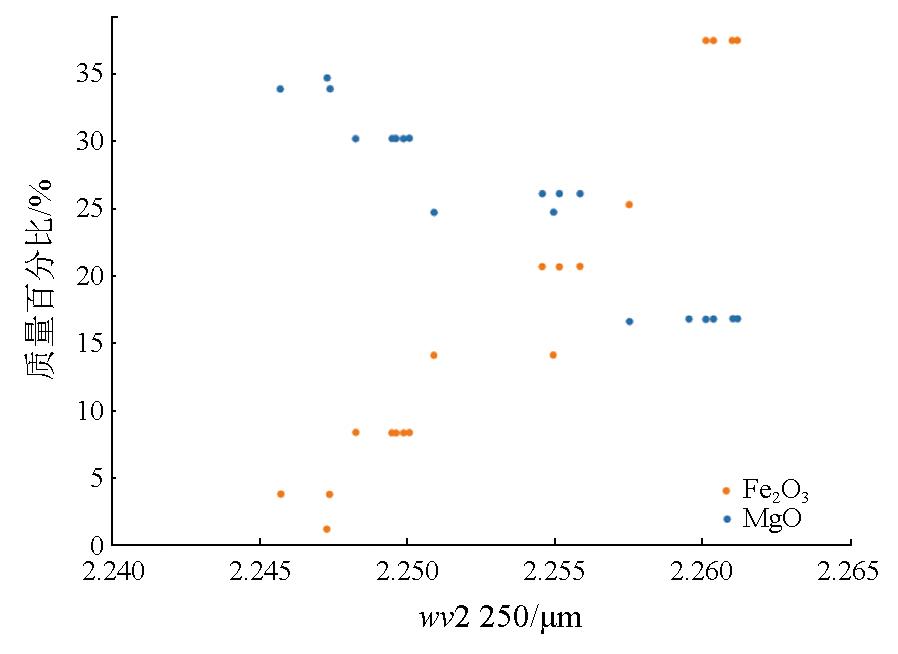
表3 USGS波谱库绿泥石样本Tab.3 Chlorite samples from the USGS spectral library |
| 样本ID | 矿物 | 光谱仪 | wv2 250/μm | MgO质量百分比/% | Fe2O3质量百分比/% |
|---|---|---|---|---|---|
| NMNH83369 | 镁硬绿泥石 | NIC4 | 2.246 | 33.9 | 3.76 |
| GDS159 | 硬绿泥石 | NIC4 | 2.247 | 34.7 | 1.16 |
| NMNH83369 | 镁硬绿泥石 | NIC4 | 2.247 | 33.9 | 3.76 |
| SMR-13.b | 富镁绿泥石 | BECK | 2.248 | 30.2 | 8.34 |
| SMR-13.a | 富镁绿泥石 | BECK | 2.249 | 30.2 | 8.34 |
| SMR-13.d | 富镁绿泥石 | NIC4 | 2.250 | 30.2 | 8.34 |
| SMR-13.c | 富镁绿泥石 | NIC4 | 2.250 | 30.2 | 8.34 |
| SMR-13.d | 富镁绿泥石 | BECK | 2.250 | 30.2 | 8.34 |
| SMR-13.a | 富镁绿泥石 | NIC4 | 2.250 | 30.2 | 8.34 |
| SMR-13.a | 富镁绿泥石 | NIC4 | 2.250 | 30.2 | 8.34 |
| GDS158 | 硬绿泥石 | ASDNG | 2.251 | 24.7 | 14.10 |
| SC-CCa-1.b | 含铁硬绿泥石 | BECK | 2.255 | 26.1 | 20.70 |
| GDS158 | 硬绿泥石 | BECK | 2.255 | 24.7 | 14.10 |
| SC-CCa-1.a | 含铁硬绿泥石 | NIC4 | 2.255 | 26.1 | 20.70 |
| SC-CCa-1.b | 含铁硬绿泥石 | NIC4 | 2.256 | 26.1 | 20.70 |
| GDS157 | 含铁硬绿泥石 | BECK | 2.258 | 16.6 | 25.30 |
| SMR-15.b | 鳞绿泥石 | BECK | 2.260 | 16.8 | 37.50 |
| SMR-15.a | 鳞绿泥石 | NIC4 | 2.260 | 16.8 | 37.50 |
| SMR-15.d | 鳞绿泥石 | NIC4 | 2.260 | 16.8 | 37.50 |
| SMR-15.b | 鳞绿泥石 | NIC4 | 2.261 | 16.8 | 37.50 |
| SMR-15.b | 鳞绿泥石 | NIC4 | 2.261 | 16.8 | 37.50 |
| SMR-15.c | 鳞绿泥石 | NIC4 | 2.261 | 16.8 | 37.50 |
| [1] |
杨国鹏, 余旭初, 冯伍法, 等. 高光谱遥感技术的发展与应用现状[J]. 测绘通报, 2008(10):1-4.
|
| [2] |
甘甫平, 董新丰, 闫柏琨, 等. 光谱地质遥感研究进展[J]. 南京信息工程大学学报(自然科学版), 2018, 10(1):44-62.
|
| [3] |
代晶晶, 赵龙贤, 姜琪, 等. 热红外高光谱技术在地质找矿中的应用综述[J]. 地质学报, 2020, 94(8):2520-2533.
|
| [4] |
孙雨, 赵英俊, 秦凯, 等. 基于航空成像高光谱数据的玉石矿找矿要素识别和找矿预测——以青海省纳赤台地区为例[J]. 地质论评, 2017, 63(s1):203-204.
|
| [5] |
赵佳琪, 董新丰, 李娜, 等. 基于高光谱数据的甘肃花西山金矿蚀变特征分析与找矿预测应用[J]. 地质与勘探, 2023, 59(1):122-133.
|
| [6] |
孙雨, 刘家军, 赵英俊, 等. 基于GF-5高光谱数据的蚀变矿物填图及地质应用——以甘肃省瓜州县花牛山地区为例[J]. 中国地质, 2022, 49(2):558-574.
|
| [7] |
王聪聪, 陈川, 李云鹏, 等. 东天山帕尔岗塔格西斑岩铜矿高光谱遥感蚀变特征及其对找矿的指示意义[J]. 地质与勘探, 2023, 59(6):1171-1181.
|
| [8] |
孙雨, 刘家军, 翟德高, 等. 基于资源一号02D卫星高光谱数据的甘肃头吊泉-南大滩地区蚀变矿物填图及金矿化带识别[J]. 地质与勘探, 2022, 58(2):399-409.
|
| [9] |
赵志芳, 张新乐, 陈琪, 等. 普朗斑岩型铜矿区矿化蚀变特征矿物填图及找矿潜力分析:来自资源一号02D遥感卫星的证据[J]. 沉积与特提斯地质, 2022, 42(1):17-29.
|
| [10] |
李根军, 杨雪松, 张兴, 等. ZY1-02D高光谱数据在地质矿产调查中的应用与分析[J]. 国土资源遥感, 2021, 33(2):134-140.doi:10.6046/gtzyyg.2020190.
|
| [11] |
江思宏, 聂凤军, 胡朋, 等. 北山地区岩浆活动与金矿成矿作用关系探讨[J]. 矿床地质, 2006, 25(s1):269-272.
|
| [12] |
|
| [13] |
俞胜, 赵斌斌, 贾轩, 等. 北山造山带南缘一条山北闪长岩地球化学、年代学特征及其构造意义[J]. 西北地质, 2022, 55(4):267-279.
|
| [14] |
江彪, 王登红, 马玉波, 等. 北山及其相邻地区主要矿床类型、找矿新进展及方向[J]. 地质学报, 2022, 96(6):2206-2216.
|
| [15] |
袁伟恒, 顾雪祥, 章永梅, 等. 甘肃北山地区小西弓金矿床成矿流体性质及矿床成因[J]. 现代地质, 2020, 34(3):554-568.
|
| [16] |
丁书宏. 甘肃北山前红泉金矿床绢云母40Ar-39Ar年龄及其地质意义[J]. 黄金科学技术, 2021, 29(2):173-183.
|
| [17] |
王玉玺, 马涛, 张愿宁, 等. 甘肃北山南带地质找矿新进展与找矿方向[J]. 新疆地质, 2023, 41(s1):35.
|
| [18] |
杨镇熙, 丁书宏, 张晶, 等. 甘肃北山南带前红泉金矿的发现及其找矿意义[J]. 西北地质, 2023, 56(6):274-284.
|
| [19] |
张晶, 杨镇熙, 陈世明, 等. 甘肃北山南带发现前红泉大型金矿床(30.6吨)[J]. 中国地质, 2024, 51(4):1443-1444.
|
| [20] |
韩月, 柯樱海, 王展鹏, 等. 资源一号02D卫星高光谱数据黄河三角洲湿地景观分类[J]. 遥感学报, 2023, 27(6):1387-1399.
|
| [21] |
|
| [22] |
|
| [23] |
|
| [24] |
|
| [25] |
|
| [26] |
|
/
| 〈 |
|
〉 |