
Remote Sensing for Natural Resources >
Spatiotemporal evolution and prediction of ecosystem carbon storage in Xianyang City based on the PLUS-InVEST model
Received date: 2024-06-14
Revised date: 2024-08-28
Online published: 2026-06-03
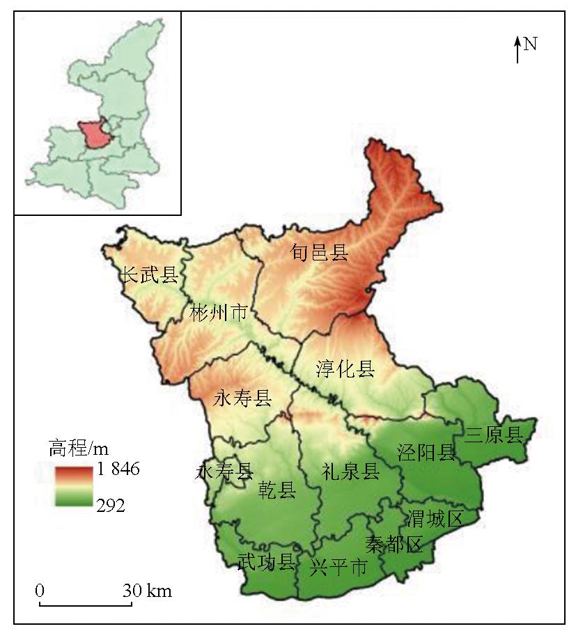
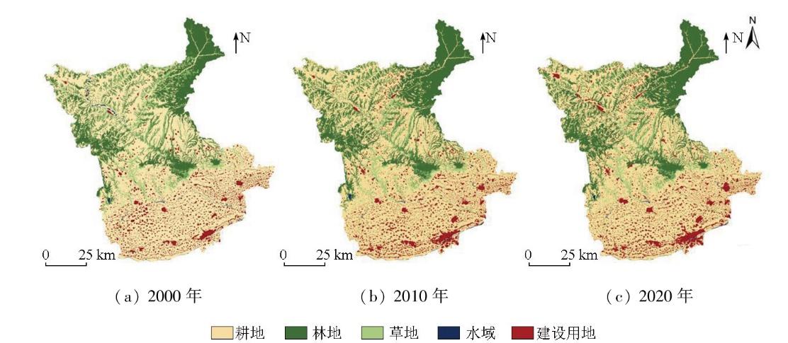
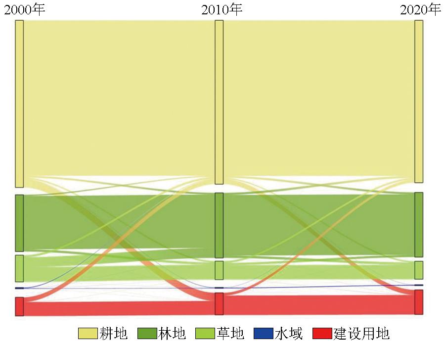
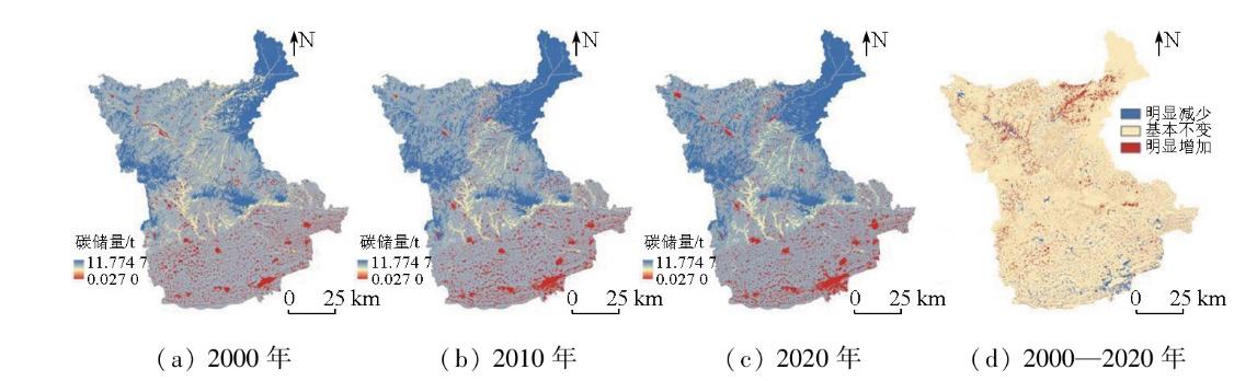
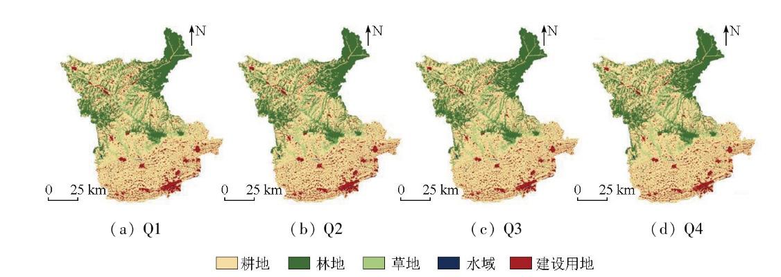
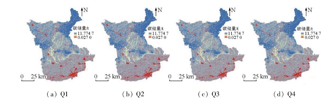
Land use change is a primary driver of carbon storage changes in terrestrial ecosystems. Investigating its impact on carbon storage is crucial for optimizing territorial spatial planning and reducing regional carbon emissions. Focusing on Xianyang City,this study analyzed changes in land use and carbon storage over the past two decades (2000—2020) based on corresponding land-use data from 2000,2010,and 2020,using the patch-generating land use simulation (PLUS) and integrated valuation of ecosystem services and tradeoffs (InVEST) models. Moreover,it predicted the distribution of carbon storage in 2030 under four scenarios:natural growth,urban development,cropland protection,and ecological protection. The results indicate that in 2000,2010,and 2020,Xianyang City exhibited carbon storage of 10 047.534×10⁴ t,10 120.754×10⁴ t,and 10 030.210×10⁴ t,respectively,characterized by a pattern of an initial increase followed by a decrease. The conversion of grassland to forest and cropland to construction land was identified as the main factor contributing to the increase and decrease in carbon storage,respectively. Among the four scenarios for 2030,cropland protection and ecological protection scenarios displayed increased carbon storage,while the urban development scenario experienced the most significant decline in carbon storage due to the rapid expansion of construction land. Areas with high carbon storage were mainly concentrated in northern Xianyang,whereas those with low carbon storage were distributed in the southern economic centers. Looking ahead,the future planning in Xianyang should fully consider the impacts of land use on carbon storage,ecological land protection,and restriction of extensive construction land expansion. By doing so,the city can achieve dual optimization of land use and carbon emissions. The findings provide a scientific basis and data reference for enhancing ecosystem carbon sink capacity and optimizing terrestrial spatial planning in Xianyang City.
CHEN Qiuji , XIE Mimi , NAN Dandan , LUO Hao . Spatiotemporal evolution and prediction of ecosystem carbon storage in Xianyang City based on the PLUS-InVEST model[J]. Remote Sensing for Natural Resources, 2025 , 37(5) : 172 -182 . DOI: 10.6046/zrzyyg.2024215
表1 研究区不同土地利用类型碳密度Tab.1 Carbon density of each land type in the study area (t/hm2) |
| 土地利 用类型 | 地上 碳密度 | 地下 碳密度 | 土壤 碳密度 | 死亡有机 物碳密度 |
|---|---|---|---|---|
| 耕地 | 28.14 | 3.20 | 72.50 | 0 |
| 林地 | 24.56 | 5.97 | 87.30 | 13 |
| 草地 | 1.59 | 4.57 | 60.19 | 2.11 |
| 水域 | 0.30 | 0 | 0 | 0 |
| 建设用地 | 2.35 | 0 | 0 | 0 |
表2 多情景转移矩阵Tab.2 Multi-scenario transition matrix |
| 地类 | Q1 | Q2 | Q3 | Q4 | ||||||||||||||||
|---|---|---|---|---|---|---|---|---|---|---|---|---|---|---|---|---|---|---|---|---|
| 耕地 | 林地 | 草地 | 水域 | 建设 用地 | 耕地 | 林地 | 草地 | 水域 | 建设 用地 | 耕地 | 林地 | 草地 | 水域 | 建设 用地 | 耕地 | 林地 | 草地 | 水域 | 建设 用地 | |
| 耕地 | 1 | 1 | 1 | 1 | 1 | 1 | 1 | 1 | 1 | 1 | 1 | 0 | 0 | 0 | 0 | 1 | 1 | 1 | 1 | 1 |
| 林地 | 1 | 1 | 1 | 0 | 1 | 1 | 1 | 1 | 1 | 1 | 1 | 1 | 1 | 0 | 0 | 0 | 1 | 0 | 0 | 0 |
| 草地 | 1 | 1 | 1 | 1 | 1 | 1 | 1 | 1 | 1 | 1 | 1 | 1 | 1 | 1 | 1 | 0 | 1 | 1 | 1 | 0 |
| 水域 | 1 | 0 | 1 | 1 | 0 | 1 | 1 | 1 | 1 | 1 | 1 | 0 | 1 | 1 | 0 | 0 | 0 | 0 | 1 | 0 |
| 建设用地 | 1 | 1 | 1 | 1 | 1 | 0 | 1 | 1 | 0 | 1 | 1 | 0 | 0 | 0 | 1 | 1 | 1 | 1 | 1 | 1 |
表3 咸阳市2000—2020年各地类碳储量Tab.3 Carbon storage of each land type in Xianyang City from 2000 to 2020 (104t) |
| 地类 | 2000年 | 2010年 | 2020年 | 2000—2020年 变化量 |
|---|---|---|---|---|
| 耕地 | 6 540.08 | 6 412.07 | 6 353.04 | -187.03 |
| 林地 | 2 800.66 | 3 211.59 | 3 190.63 | 389.97 |
| 草地 | 690.08 | 477.30 | 464.57 | -225.51 |
| 水域 | 0.15 | 0.11 | 0.10 | -0.05 |
| 建设用地 | 16.56 | 19.69 | 21.85 | 5.29 |
| 总计 | 10 047.53 | 10 120.75 | 10 030.20 | -17.33 |
表4 2000—2020年地类转移引起的碳储量变化Tab.4 Changes in carbon stocks caused by land type transfers from 2000 to 2020 |
| 土地利用 类型转化 | 面积/km2 | 植被碳储 量变化/ 104 t | 土壤碳储 量变化/ 104 t | 总碳储量 变化/ 104 t |
|---|---|---|---|---|
| 耕地-林地 | 105.66 | -0.86 | 29.37 | 28.52 |
| 耕地-草地 | 67.61 | -17.03 | -6.90 | -23.92 |
| 耕地-水域 | 16.98 | -5.27 | -12.31 | -17.58 |
| 耕地-建设用地 | 428.14 | -124.12 | -310.40 | -434.52 |
| 小计 | 618.39 | -147.27 | -300.24 | -447.51 |
| 林地-耕地 | 78.48 | 0.64 | -21.82 | -21.18 |
| 林地-草地 | 121.35 | -29.57 | -46.11 | -75.69 |
| 林地-水域 | 3.05 | -0.92 | -3.06 | -3.99 |
| 林地-建设用地 | 1.84 | -0.52 | -1.85 | -2.36 |
| 小计 | 204.72 | -30.38 | -72.84 | -103.22 |
| 草地-耕地 | 119.98 | 30.21 | 12.24 | 42.45 |
| 草地-林地 | 394.00 | 96.02 | 149.72 | 245.74 |
| 草地-水域 | 3.51 | -0.21 | -2.18 | -2.39 |
| 草地-建设用地 | 8.10 | -0.31 | -5.05 | -5.36 |
| 小计 | 525.59 | 125.71 | 154.72 | 280.44 |
| 水域-耕地 | 28.84 | 8.95 | 20.91 | 29.86 |
| 水域-林地 | 2.86 | 0.87 | 2.87 | 3.74 |
| 水域-草地 | 3.91 | 0.23 | 2.44 | 2.67 |
| 水域-建筑用地 | 1.80 | 0.04 | 0.00 | 0.04 |
| 小计 | 37.42 | 10.08 | 26.22 | 36.30 |
| 建设用地-耕地 | 210.98 | 61.16 | 152.96 | 214.12 |
| 建设用地-林地 | 0.28 | 0.08 | 0.29 | 0.37 |
| 建设用地-草地 | 3.30 | 0.13 | 2.06 | 2.18 |
| 建设用地-水域 | 0.27 | -0.01 | 0.00 | -0.01 |
| 小计 | 214.83 | 61.36 | 155.30 | 216.66 |
| 总计 | 1 600.95 | 19.51 | -36.84 | -17.32 |
表5 咸阳市2030年4种情景下各地类面积及其变化率Tab.5 Land type area and change rate unde four scenarios in Xianyang City in 2030 |
| 地类 | 面积/km2 | 变化率/% | |||||||
|---|---|---|---|---|---|---|---|---|---|
| 2020年 | Q1 | Q2 | Q3 | Q4 | Q1 | Q2 | Q3 | Q4 | |
| 耕地 | 6 118.11 | 6 072.93 | 6 036.62 | 6 145.38 | 6 103.87 | -0.74 | -1.33 | 0.45 | -0.23 |
| 林地 | 2 438.76 | 2 421.02 | 2 419.87 | 2 425.98 | 2 467.97 | -0.73 | -0.77 | -0.52 | 1.20 |
| 草地 | 678.60 | 663.24 | 661.78 | 663.83 | 655.74 | -2.26 | -2.48 | -2.18 | -3.37 |
| 水域 | 35.76 | 35.21 | 35.11 | 35.30 | 35.76 | -1.53 | -1.82 | -1.29 | 0.01 |
| 建设用地 | 929.92 | 1 008.76 | 1 047.78 | 930.66 | 937.81 | 8.48 | 12.67 | 0.08 | 0.85 |
表6 咸阳市2030年4种情景下各地类碳储量Tab.6 The carbon storage of each land type in Xianyang City under four scenarios in 2030 (104t) |
| 地类 | 2020年 | Q1 | Q2 | Q3 | Q4 |
|---|---|---|---|---|---|
| 耕地 | 6 353.045 | 6 306.126 | 6 268.429 | 6 381.367 | 6 338.256 |
| 林地 | 3 190.634 | 3 167.423 | 3 165.910 | 3 173.910 | 3 228.844 |
| 草地 | 464.571 | 454.055 | 453.057 | 454.456 | 448.921 |
| 水域 | 0.107 | 0.106 | 0.105 | 0.106 | 0.107 |
| 建设用地 | 21.853 | 23.706 | 24.623 | 21.871 | 22.039 |
| 总计 | 10 030.210 | 9 951.414 | 9 912.123 | 10 031.711 | 10 038.168 |
| [1] |
|
| [2] |
孙方虎, 方凤满, 洪炜林, 等. 基于PLUS和InVEST模型的安徽省碳储量演化分析与预测[J]. 水土保持学报, 2023, 37(1):151-158.
|
| [3] |
|
| [4] |
张鹏, 李良涛, 苏玉姣, 等. 基于PLUS和InVEST模型的邯郸市碳储量空间分布特征研究[J]. 水土保持通报, 2023, 43(3):338-348.
|
| [5] |
|
| [6] |
|
| [7] |
刘晓娟, 黎夏, 梁迅, 等. 基于FLUS-InVEST模型的中国未来土地利用变化及其对碳储量影响的模拟[J]. 热带地理, 2019, 39(3):397-409.
|
| [8] |
朱文博, 张静静, 崔耀平, 等. 基于土地利用变化情景的生态系统碳储量评估——以太行山淇河流域为例[J]. 地理学报, 2019, 74(3):446-459.
|
| [9] |
谢宇剑, 沈正平, 赵洁. 基于土地利用变化情景的徐州市生态系统碳储量评估[J]. 国土与自然资源研究, 2022(4):13-21.
|
| [10] |
王超越, 郭先华, 郭莉, 等. 基于FLUS-InVEST的西北地区土地利用变化及其对碳储量的影响——以呼包鄂榆城市群为例[J]. 生态环境学报, 2022, 31(8):1667-1679.
|
| [11] |
|
| [12] |
朱志强, 马晓双, 胡洪. 基于耦合FLUS-InVEST模型的广州市生态系统碳储量时空演变与预测[J]. 水土保持通报, 2021, 41(2):222-229,239.
|
| [13] |
于文慧, 徐兆阳, 陈春森, 等. 逻辑回归元胞自动机模型的鸡西市城市扩张分析及预测[J]. 测绘与空间地理信息, 2022, 45(1):45-49,54.
|
| [14] |
|
| [15] |
高周冰, 王晓瑞, 隋雪艳, 等. 基于FLUS和InVEST模型的南京市生境质量多情景预测[J]. 农业资源与环境学报, 2022, 39(5):1001-1013.
|
| [16] |
伍丹, 朱康文, 张晟, 等. 基于PLUS模型和InVEST模型的成渝经济区碳储量演化分析[J]. 三峡生态环境监测, 2022, 7(2):85-96.
|
| [17] |
|
| [18] |
|
| [19] |
李姣, 汪杰, 李朗, 等. 洞庭湖生态经济区土地利用变化对碳储量的影响[J]. 生态学杂志, 2022, 41(6):1156-1165.
|
| [20] |
张平平, 李艳红, 殷浩然, 等. 中国南北过渡带生态系统碳储量时空变化及动态模拟[J]. 自然资源学报, 2022, 37(5):1183-1197.
|
| [21] |
李俊, 杨德宏, 吴锋振, 等. 基于PLUS与InVEST模型的昆明市土地利用变化动态模拟与碳储量评估[J]. 水土保持通报, 2023, 43(1):378-387.
|
| [22] |
侯建坤, 陈建军, 张凯琪, 等. 基于InVEST和GeoSoS-FLUS模型的黄河源区碳储量时空变化特征及其对未来不同情景模式的响应[J]. 环境科学, 2022, 43(11):5253-5262.
|
| [23] |
|
| [24] |
孙欣欣, 薛建辉, 董丽娜. 基于PLUS模型和InVEST模型的南京市生态系统碳储量时空变化与预测[J]. 生态与农村环境学报, 2023, 39(1):41-51.
|
| [25] |
杨洁. 基于FLUS-InVEST模型的黄河流域土地利用变化模拟与碳储量估算研究[D]. 郑州: 河南大学, 2023.
|
| [26] |
岳程瑜. 陕西省森林碳储量及其碳汇潜力估算研究[D]. 杨凌: 西北农林科技大学, 2023.
|
| [27] |
古圳威, 刘京, 陈怡, 等. 陕西渭北旱塬区生境质量及碳储量时空演变分析与模拟[J]. 环境科学, 2023, 44(8):4666-4678.
|
| [28] |
段保正, 石辉, 魏小芳, 等. 西安市城区表层土壤碳储量与分布特征[J]. 水土保持通报, 2016, 36(6):293-297.
|
| [29] |
王晓晨. 基于InVEST模型的陕西秦岭(渭河流域)生态系统服务评估[D]. 西安: 西北大学, 2022.
|
| [30] |
张斌, 夏秋月, 董捷, 等. 大都市郊区土地利用变化对碳储量时空格局影响研究:以武汉市黄陂区为例[J]. 生态与农村环境学报, 2023, 39(6):699-712.
|
| [31] |
杨潋威, 赵娟, 朱家田, 等. 基于PLUS和InVEST模型的西安市生态系统碳储量时空变化与预测[J]. 自然资源遥感, 2022, 34(4):175-182.doi:10.6046/zrzyyg.2021348.
|
| [32] |
王佳楠, 张志. 基于Markov-PLUS模型的柴北缘土地利用变化及模拟分析[J]. 西北林学院学报, 2022, 37(3):139-148,179.
|
| [33] |
胡丰, 张艳, 郭宇, 等. 基于PLUS和InVEST模型的渭河流域土地利用与生境质量时空变化及预测[J]. 干旱区地理, 2022, 45(4):1125-1136.
|
| [34] |
雒舒琪, 胡晓萌, 孙媛, 等. 耦合PLUS-InVEST模型的多情景土地利用变化及其对碳储量影响[J]. 中国生态农业学报(中英文), 2023, 31(2):300-314.
|
| [35] |
江民. 西南喀斯特地区生态系统服务功能时空变化及驱动因子分析[D]. 武汉: 华中农业大学, 2022.
|
| [36] |
|
| [37] |
王成武, 罗俊杰, 唐鸿湖. 基于InVEST模型的太行山沿线地区生态系统碳储量时空分异驱动力分析[J]. 生态环境学报, 2023, 32(2):215-225.
|
/
| 〈 |
|
〉 |