
Remote Sensing for Natural Resources >
End-to-end land cover classification based on panchromatic-multispectral dual-stream convolutional network
Received date: 2024-06-12
Revised date: 2024-12-10
Online published: 2026-06-03
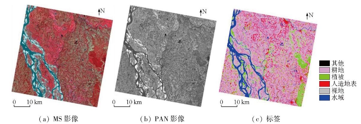
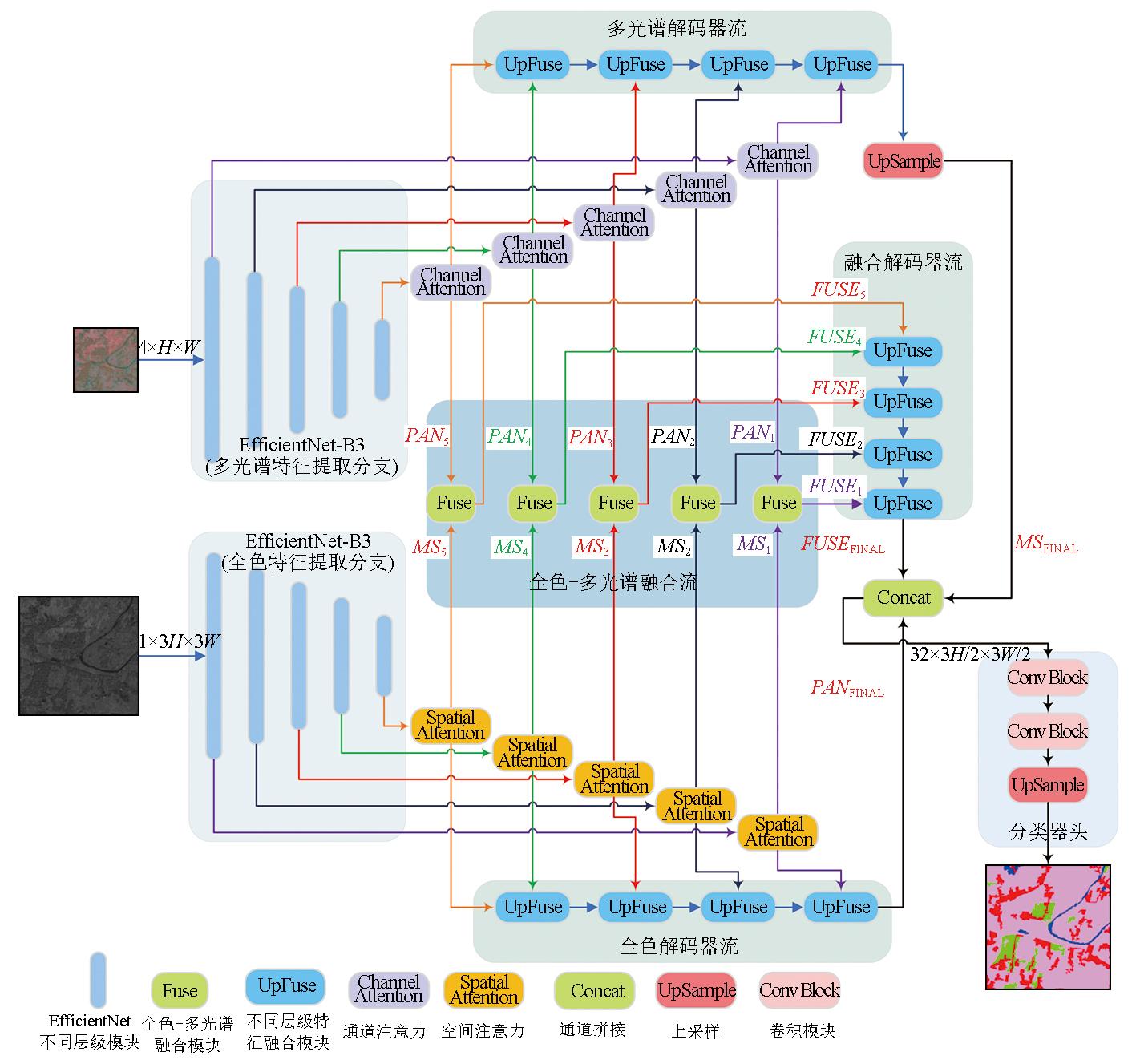
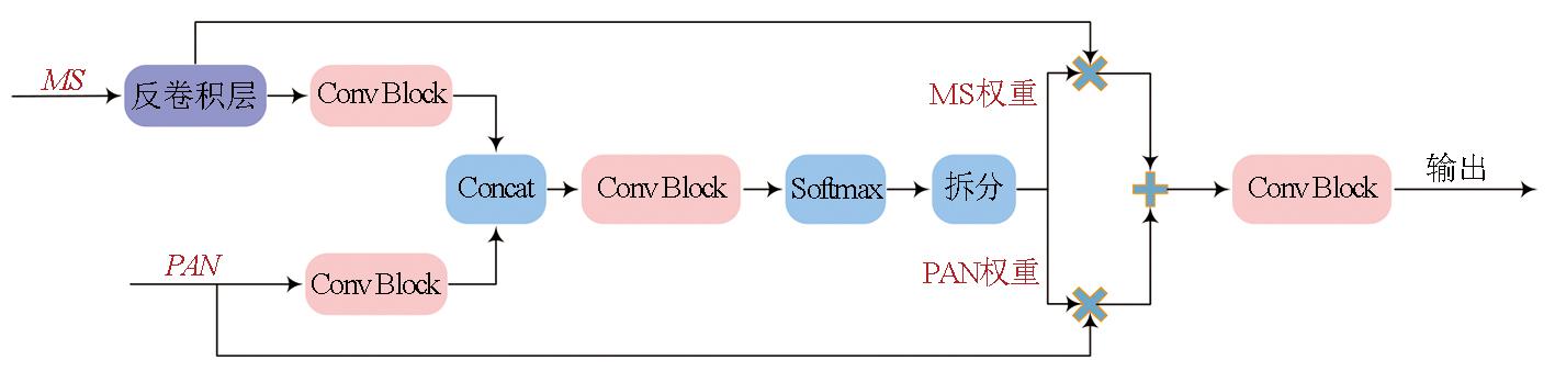
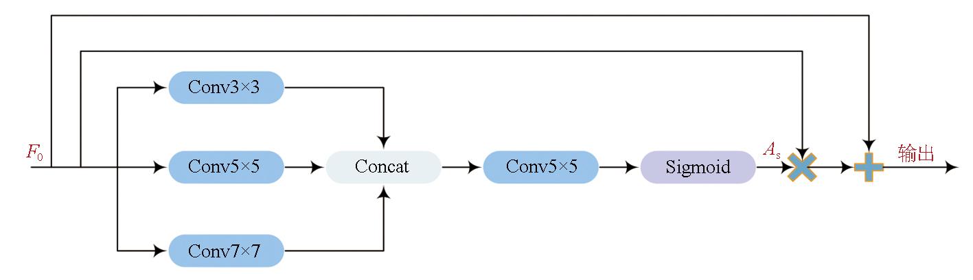
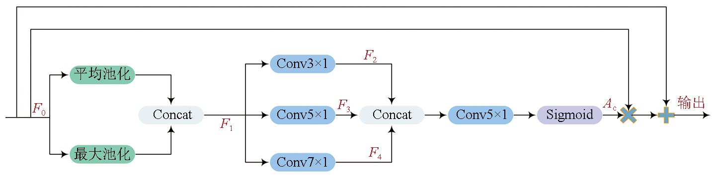
Multispectral (MS) and panchromatic (PAN) images serve as primary data sources for visible-near-infrared optical remote sensing imagery. In a typical land cover classification workflow,the spatial resolution of MS images is generally enhanced using pixel-level fusion methods,followed by image classification. However,the pixel-level fusion process is characterized by considerable time consumption and inconsistency with the optimization objectives of land cover classification,failing to meet the demand for end-to-end remote sensing image classification. To address these challenges,this paper proposed a dual-stream fully convolutional neural network,DSEUNet,which obviates the need for pixel-level fusion. Specifically,two branches were constructed based on the EfficientNet-B3 network to extract features from PAN and MS images,respectively. It was followed by feature-level fusion and decoding,thus outputting the ultimate classification results. Considering that PAN and MS images focus on different features of land cover elements,a spatial attention mechanism was incorporated in the PAN branch to enhance the perception of spatial information,such as details and edges. Moreover,a channel attention mechanism was incorporated in the MS branch to improve the perception of reflectance differences across multiple bands. Experiments on the 10-meter land cover dataset and ablation studies of the network structure demonstrate that the proposed network exhibited higher classification accuracy and faster inference speed. With the same backbone network,DSEUNet outperformed traditional pixel-level fusion-based classification methods,with an increase of 1.62 percentage points in mIoU,1.36 percentage points in mFscore,and 1.49 percentage points in Kappa coefficient,as well as a 17.69% improvement in inference speed.
LI Yinglong , DENG Yupeng , KONG Yunlong , CHEN Jingbo , MENG Yu , LIU Diyou . End-to-end land cover classification based on panchromatic-multispectral dual-stream convolutional network[J]. Remote Sensing for Natural Resources, 2025 , 37(5) : 152 -161 . DOI: 10.6046/zrzyyg.2024208
表1 在10 m地表覆盖数据集上不同方法的分类指标Tab.1 Classification index of different methods on 10 m land cover dataset (%) |
| 类别 | 方法 | IoU | mIoU | OA | mFscore | Kappa | ||||
|---|---|---|---|---|---|---|---|---|---|---|
| 耕地 | 植被 | 人造地表 | 裸地 | 水域 | ||||||
| 经典的语义 分割网络 | Deeplabv3 | 90.94 | 44.83 | 44.93 | 82.12 | 88.28 | 58.52 | 87.48 | 80.62 | 78.16 |
| PspNet | 90.77 | 44.57 | 46.58 | 82.55 | 87.76 | 58.70 | 87.57 | 80.86 | 78.36 | |
| SegNet | 91.07 | 43.73 | 43.38 | 83.84 | 89.16 | 58.53 | 87.76 | 80.43 | 78.27 | |
| HRNet | 91.34 | 45.94 | 50.74 | 83.29 | 88.88 | 60.03 | 88.44 | 82.15 | 79.72 | |
| EfficientUNet | 92.10 | 51.17 | 55.39 | 81.93 | 89.81 | 61.73 | 89.59 | 83.92 | 81.74 | |
| 遥感领域的语 义分割网络 | UNetFormer | 91.41 | 46.22 | 47.61 | 83.36 | 88.95 | 59.59 | 88.20 | 81.66 | 79.33 |
| MACUNet | 91.48 | 45.97 | 52.95 | 83.93 | 88.95 | 60.55 | 88.80 | 82.64 | 80.38 | |
| ABCNet | 91.97 | 49.11 | 58.34 | 84.34 | 88.95 | 62.12 | 89.85 | 84.21 | 82.07 | |
| MANet | 92.43 | 51.62 | 57.42 | 85.24 | 89.72 | 62.74 | 90.06 | 84.74 | 82.68 | |
| MAResUNet | 92.03 | 49.69 | 57.37 | 86.62 | 89.62 | 62.55 | 89.96 | 84.50 | 82.29 | |
| DSEUNet(本文方法) | 92.53 | 52.86 | 58.33 | 86.77 | 89.59 | 63.35 | 90.42 | 85.28 | 83.23 | |
表2 不同方法在3个测试集典型样本上可视化结果展示Tab.2 Visualization of results on typical test set images using different methods |
| 样本编号 | PAN影像 | MS影像 | 标签 | DSEUNet | EfficientUnet | MANet | MAResUnet | ||||||
|---|---|---|---|---|---|---|---|---|---|---|---|---|---|
| 样本1 | 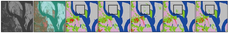 | ||||||||||||
| 样本2 | 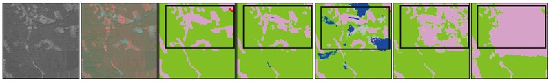 | ||||||||||||
| 样本编号 | PAN影像 | MS影像 | 标签 | DSEUNet | EfficientUnet | MANet | MAResUnet | ||||||
| 样本3 | 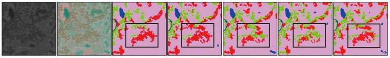 | ||||||||||||
| 图例 |  | ||||||||||||
表3 不同模型的网络效率指标Tab.3 Network efficiency indicators of different models |
| 方法 | GFLOPS | 参数量/106 | FPS |
|---|---|---|---|
| Deeplabv3 | 198.16 | 10.36 | 12.94 |
| PspNet | 181.60 | 10.33 | 10.99 |
| SegNet | 1 452.12 | 29.45 | 8.72 |
| HRNet | 166.31 | 9.64 | 15.73 |
| EfficientUNet | 132.15 | 14.09 | 10.29 |
| UNetFormer | 11.77 | 107.40 | 17.55 |
| MACUNet | 268.06 | 5.15 | 10.20 |
| ABCNet | 144.19 | 13.67 | 9.22 |
| MANet | 403.75 | 35.86 | 10.32 |
| MAResUNet | 255.84 | 26.28 | 15.67 |
| DSEUNet | 105.81 | 34.67 | 12.11 |
表4 不同融合方式的精度指标Tab.4 Precision indexes using different fusion methods (%) |
| 融合方式 | mIoU | mFscore | Kappa |
|---|---|---|---|
| 自适应融合 | 63.35 | 85.28 | 83.23 |
| 通道拼接 | 62.61 | 84.72 | 82.71 |
| 相加 | 62.57 | 84.67 | 82.70 |
| 相加相减后通道拼接 | 62.55 | 84.61 | 82.67 |
表5 注意力机制对DSEUNet的精度指标的影响Tab.5 The influence of attention mechanism on the precision index of DSEUNet (%) |
| 注意力 | mIoU | mFscore | Kappa |
|---|---|---|---|
| 无 | 62.34 | 84.34 | 82.08 |
| KA(只保留通道注意力) | 62.52 | 84.50 | 82.14 |
| KA(只保留空间注意力) | 63.16 | 85.11 | 83.05 |
| CBAM | 62.74 | 84.80 | 82.75 |
| KA | 63.35 | 85.28 | 83.23 |
表6 加入KA注意力机制前后网络对不同地表覆盖类型关注度的变化Tab.6 Changes of network attention to different land cover types before and after the addition of KA |
| 样本编号 | PAN影像 | MS影像 | 标签 | 网络对耕地类别的关注度 | 网络对植被类别的关注度 | ||
|---|---|---|---|---|---|---|---|
| 加入注意力 机制前 | 加入注意力 机制后 | 加入注意力 机制前 | 加入注意力 机制后 | ||||
| 样本1 | 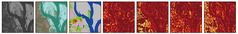 | ||||||
| 样本2 | 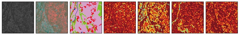 | ||||||
| 样本2 | 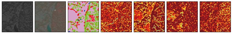 | ||||||
| 图例 |  | ||||||
| [1] |
|
| [2] |
|
| [3] |
|
| [4] |
|
| [5] |
|
| [6] |
|
| [7] |
|
| [8] |
|
| [9] |
|
| [10] |
|
| [11] |
|
| [12] |
|
| [13] |
|
| [14] |
|
| [15] |
|
| [16] |
|
| [17] |
|
| [18] |
|
| [19] |
|
| [20] |
国家基础地理中心. CH/T 9032—2022 全球地理信息资源数据产品规范[S]. 北京: 中国地图出版社, 2022.
National Geomatics Center of China. CH/T 9032—2022 Global geographic information resource data product specification[S]. Beijing: China Cartographic Publishing House, 2022.
|
| [21] |
|
| [22] |
|
| [23] |
|
| [24] |
|
| [25] |
|
| [26] |
|
| [27] |
|
| [28] |
|
| [29] |
|
| [30] |
|
| [31] |
|
| [32] |
|
| [33] |
|
| [34] |
|
/
| 〈 |
|
〉 |