
Remote Sensing for Natural Resources >
A method for inversion of urban land surface temperature and its application in domestic high-resolution thermal infrared data
Received date: 2024-02-28
Revised date: 2024-06-18
Online published: 2026-06-03
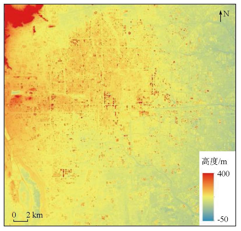
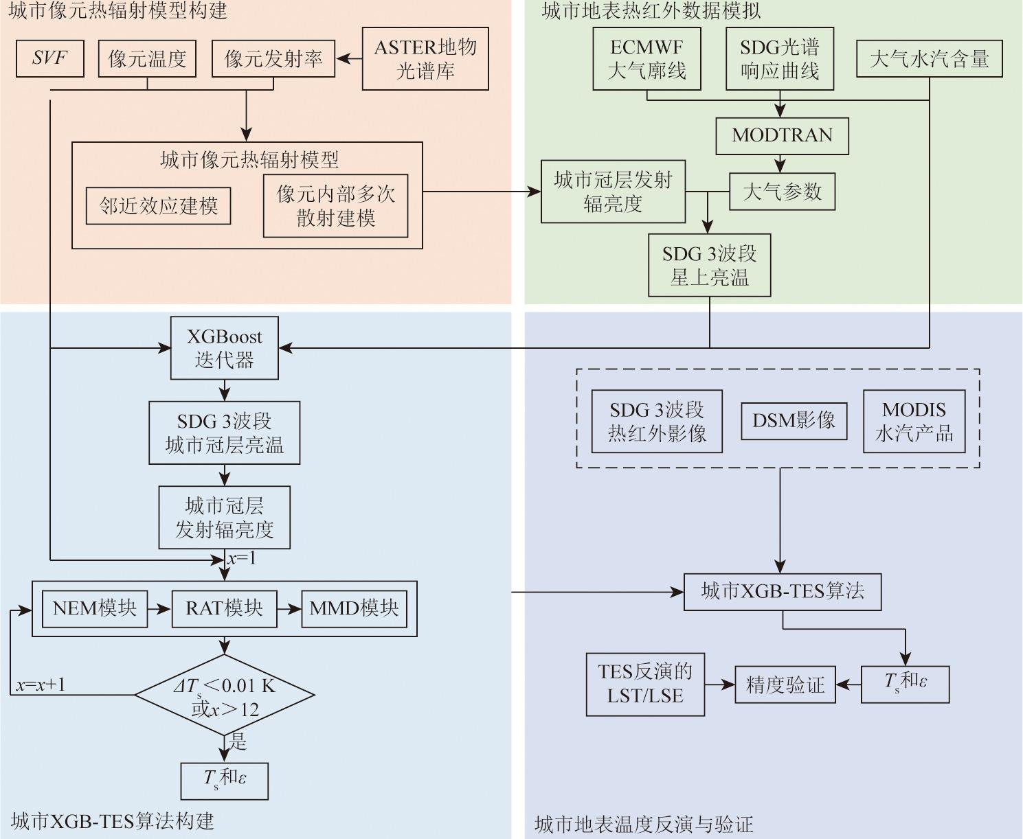
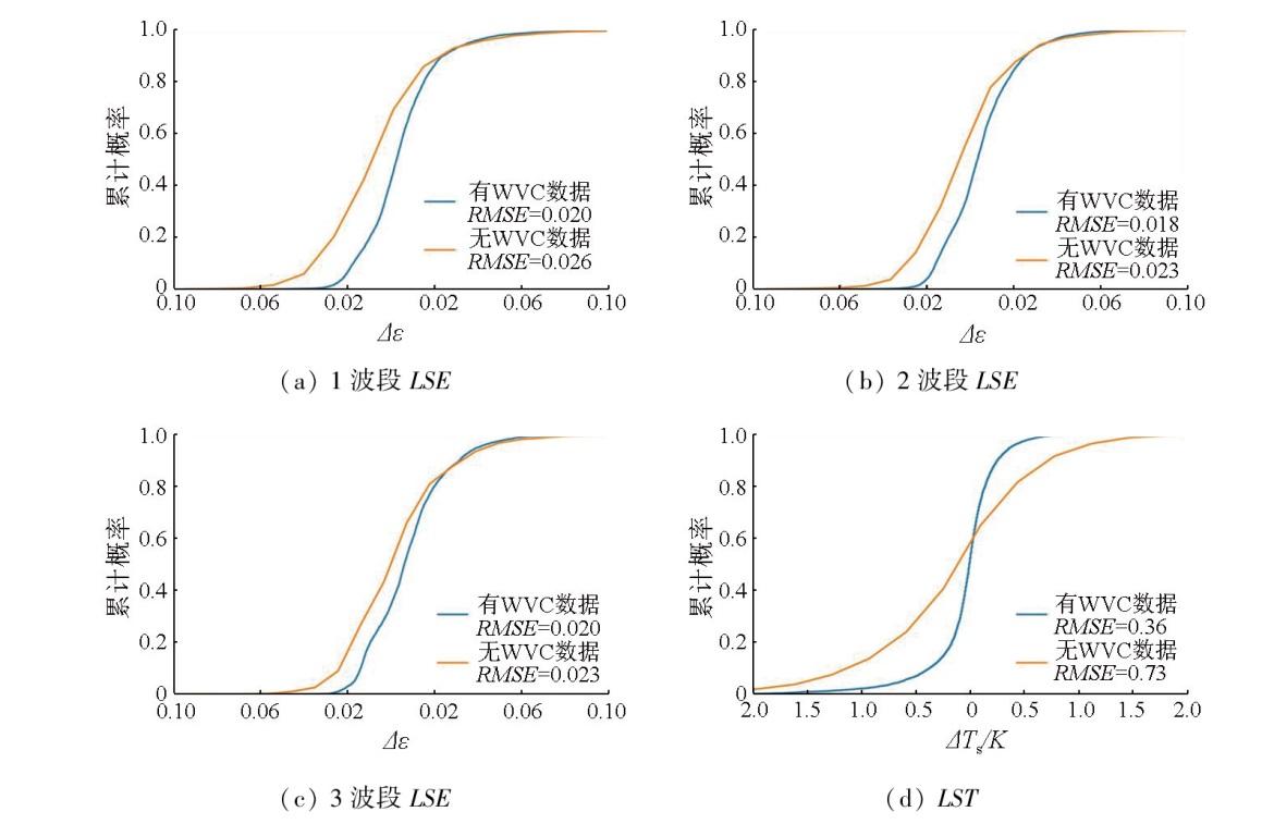
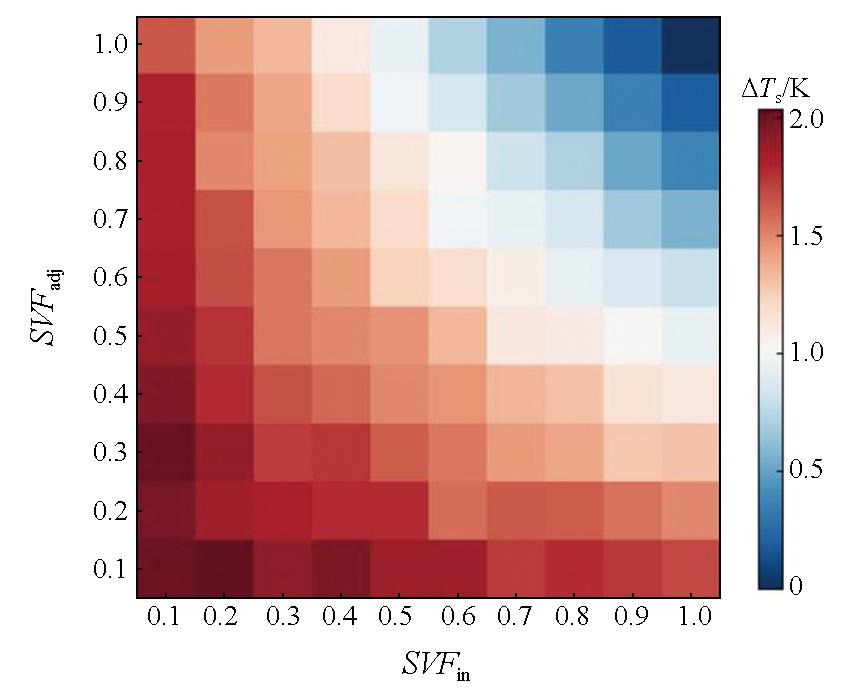
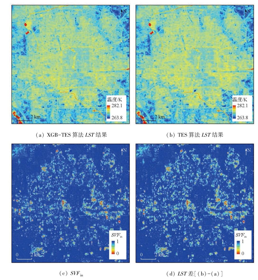
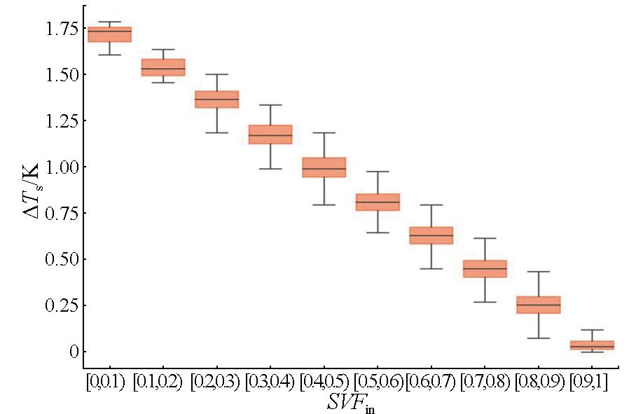
Compared to natural surfaces, urban surfaces have more complex geometric structures, leading to significant impacts of the multiple scattering effect within pixels and the neighborhood effect on the inversion results of urban land surface temperature (LST). This study proposed a novel urban LST inversion algorithm that integrates machine learning and an enhanced temperature and emissivity separation (TES) method. Finally, the proposed algorithm was applied to China’s SDGSAT-1 thermal infrared data. The algorithm comprises three key steps: First, the inversion of urban canopy brightness temperature from SDGSAT-1 data was conducted using the eXtreme Gradient Boosting (XGBoost) algorithm. Second, an enhanced TES algorithm based on the sky view factor (SVF) was developed to account for urban geometry, enabling high-precision urban LST inversion. Third, the accuracy of the inversion algorithm was assessed and applied to the urban area of Beijing. The results demonstrate that inversion using an XGBoost algorithm and a split-window algorithm yielded root mean squared errors (RMSEs) of approximately 0.2 K and 1.2 K, respectively. The LST RMSEs with and without available water vapor data were determined at 0.36 K and 0.73 K, respectively; and the LSE RMSEs under three bands were 0.020/0.026, 0.018/0.023, and 0.020/0.023, respectively. The differences in the LST inversion results derived using the original and improved TES algorithm ranged from 0 to 1.86 K.
LI Jinglun , CHEN Hong , LI Kun , DOU Xianhui , ZHAO Hang , ZENG Jian , ZHANG Xuewen , QIAN Yonggang . A method for inversion of urban land surface temperature and its application in domestic high-resolution thermal infrared data[J]. Remote Sensing for Natural Resources, 2025 , 37(4) : 68 -76 . DOI: 10.6046/zrzyyg.2024083
表1 SDGSAT-1卫星热红外光谱仪技术指标Tab.1 SDGSAT-1 satellite thermal infrared spectrometer technical specifications |
| 项目 | 指标 |
|---|---|
| 幅宽/km | 300 |
| 波段范围/μm | 8~10.5 10.3~11.3 11.5~12.5 |
| 空间分辨率/m | 30 |
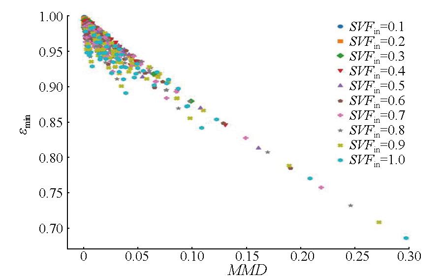
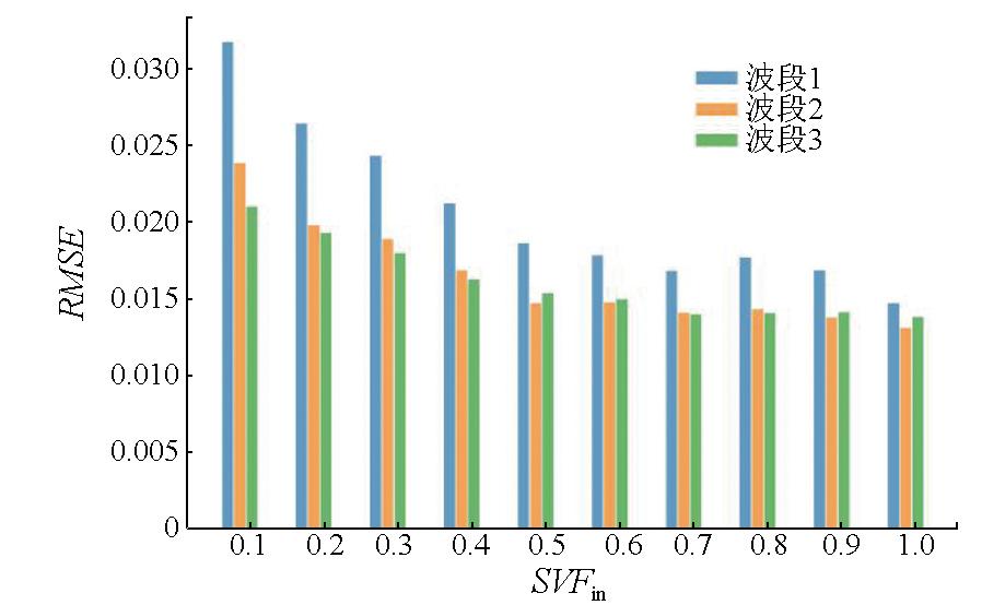
表2 不同SVFin值下 MMD 模块的系数和发射率RMSETab.2 Regression coefficients and RMSE of the SVFin-MMD relationship |
| 系数 | ||||
|---|---|---|---|---|
| a | b | c | RMSE | |
| 0.1 | 0.996 5 | 1.229 9 | 1.028 4 | 0.001 6 |
| 0.2 | 0.993 1 | 1.164 0 | 1.021 3 | 0.003 2 |
| 0.3 | 0.989 8 | 1.118 3 | 1.014 4 | 0.004 7 |
| 0.4 | 0.986 4 | 1.082 3 | 1.007 9 | 0.006 2 |
| 0.5 | 0.983 2 | 1.052 2 | 1.001 7 | 0.007 6 |
| 0.6 | 0.980 0 | 1.026 4 | 0.995 7 | 0.009 1 |
| 0.7 | 0.976 8 | 1.003 6 | 0.989 9 | 0.010 5 |
| 0.8 | 0.973 6 | 0.983 4 | 0.984 4 | 0.011 9 |
| 0.9 | 0.970 5 | 0.965 1 | 0.979 0 | 0.013 2 |
| 1.0 | 0.967 4 | 0.948 4 | 0.973 9 | 0.014 6 |
| [1] |
|
| [2] |
|
| [3] |
|
| [4] |
|
| [5] |
|
| [6] |
|
| [7] |
|
| [8] |
|
| [9] |
|
| [10] |
|
| [11] |
李召良, 段四波, 唐伯惠, 等. 热红外地表温度遥感反演方法研究进展[J]. 遥感学报, 2016, 20(5):899-920.
|
| [12] |
|
| [13] |
|
| [14] |
|
| [15] |
|
| [16] |
|
| [17] |
|
| [18] |
|
| [19] |
|
| [20] |
|
| [21] |
|
| [22] |
|
| [23] |
|
| [24] |
|
| [25] |
|
/
| 〈 |
|
〉 |
