
Remote Sensing for Natural Resources >
Optical remote sensing-based cloud detection and extraction method for tropical and subtropical vegetation areas
Received date: 2024-04-19
Revised date: 2024-07-01
Online published: 2026-06-03
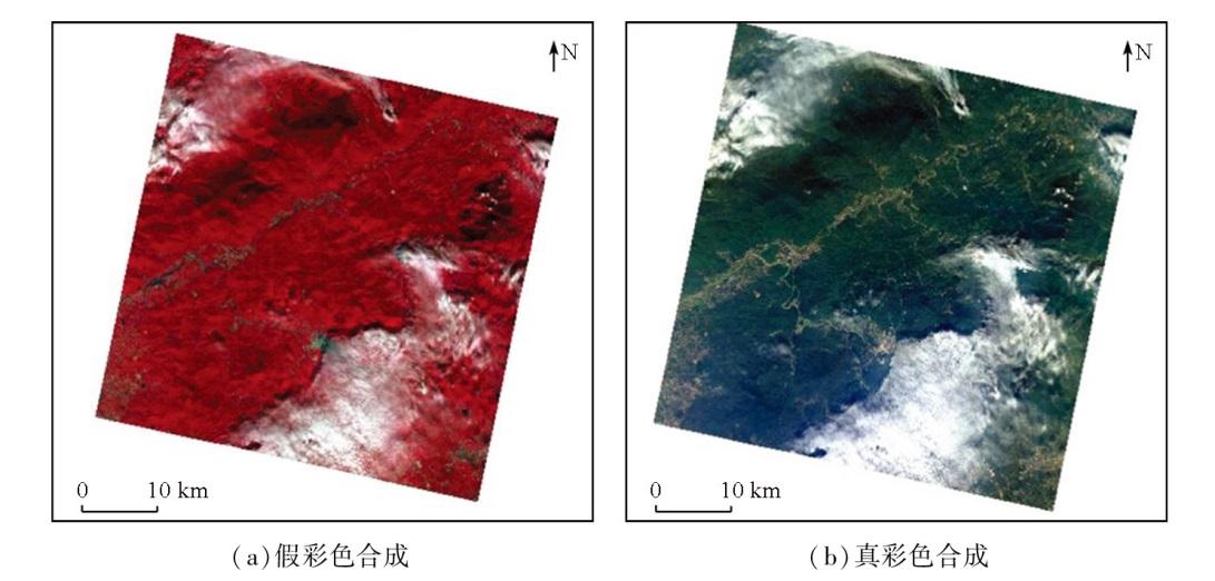
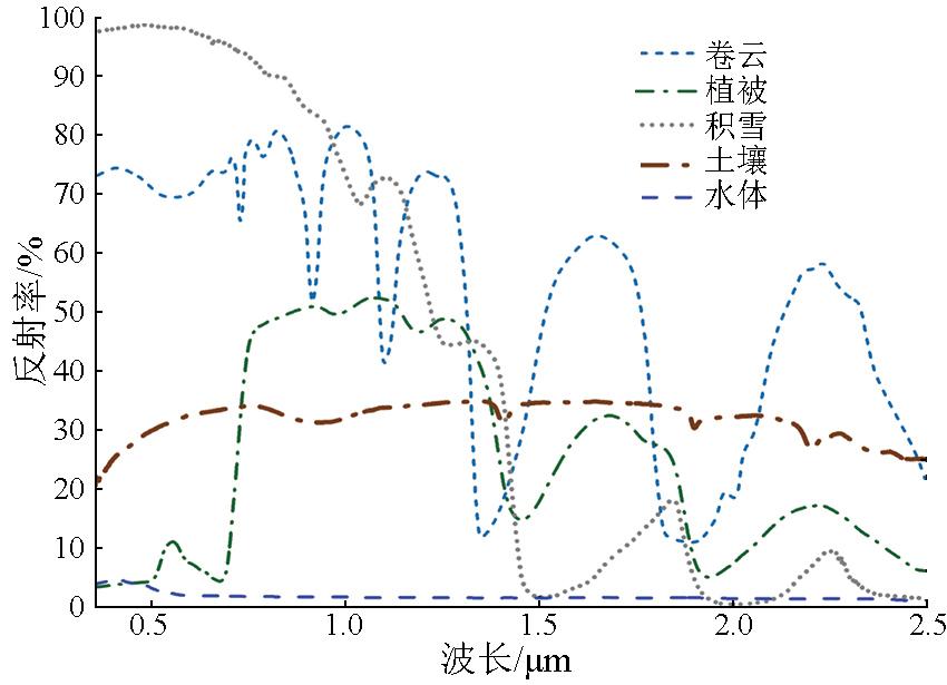
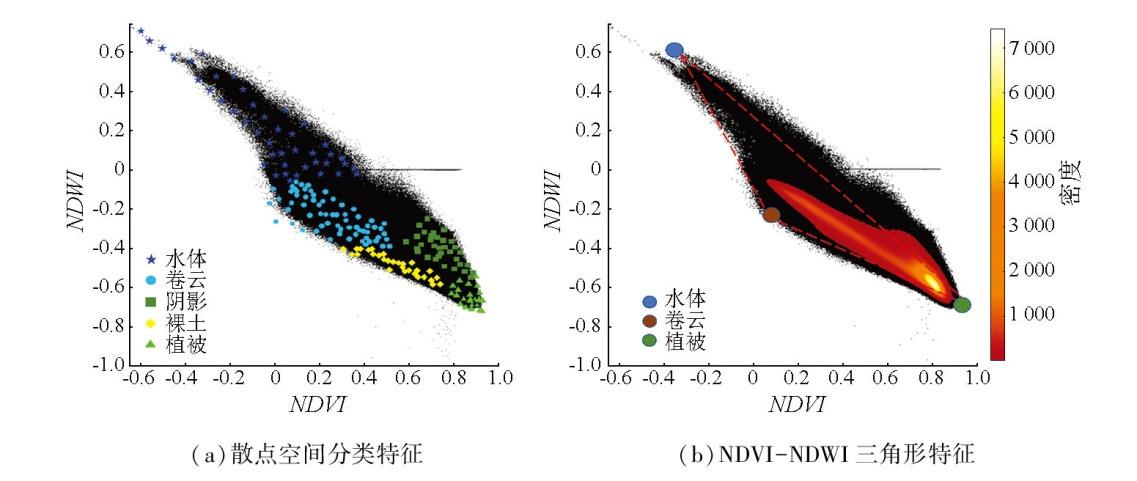
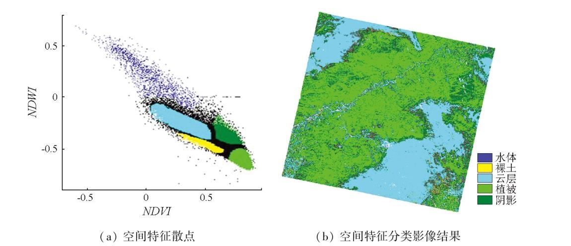
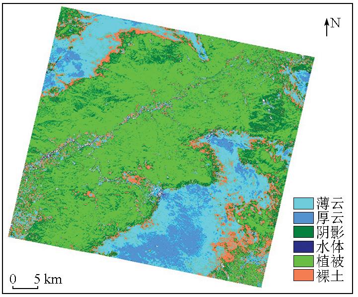
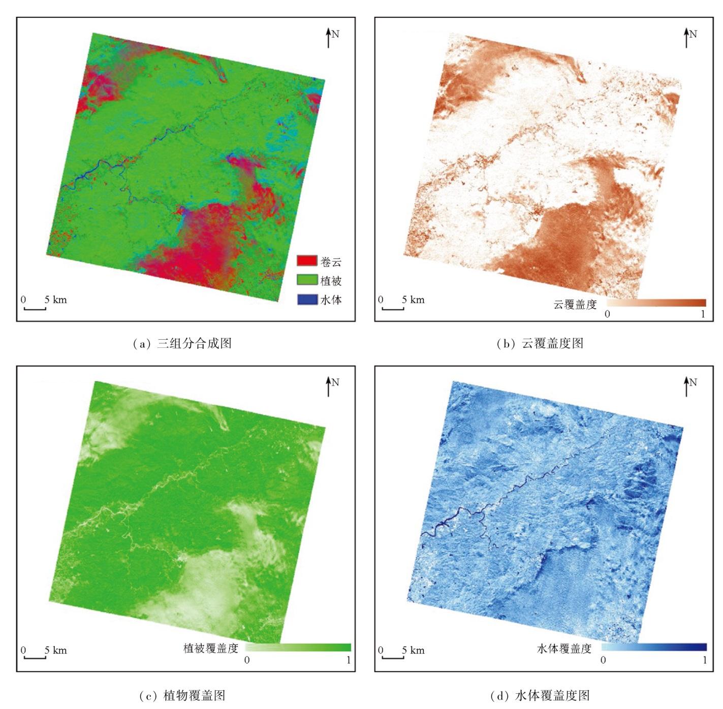
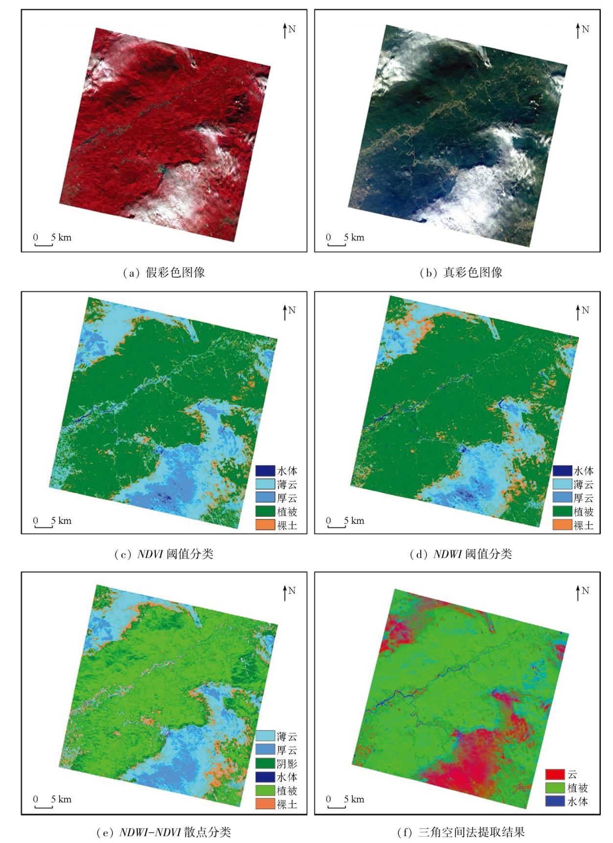
Optical satellite remote sensing images of tropical and subtropical vegetation areas are often affected by cloud cover, leading to missing remote sensing information of surface features. Effectively detecting clouds, classifying clouds and objects, and extracting cloud cover information remain hot topics and challenges in remote sensing research. Many optical cameras in domestic satellites lack the short-wave and thermal infrared spectral bands, which are used in prevailing cloud detection algorithms, reducing the image data availability after cloud removal. Hence, this study suggested detecting the spatial distribution of cloud cover by utilizing only several spectral bands in the visible light - near-infrared range (400 nm to 1 000 nm). Based on the hyperspectral remote sensing images from the Zhuhai-1 satellite, this study constructed feature space scatter plots using spectral indices, including normalized difference vegetation index (NDVI) and normalized differential water index (NDWI), for cloud/object classification and detection. Moreover, this study extracted the cloud, water, and vegetation cover information from mixed pixels. The results demonstrate that compared to conventional cloud detection methods using spectral index thresholds, the cloud detection algorithm under the NDWI-NDVI feature space used in this study exhibited a superior cloud-water separation capability and simple operability. It can precisely describe the spatial distribution characteristics of cloud cover by suppressing the shadow effect on cloud cover. Overall, this study offers a novel technical approach for further developing cloud detection, cloud-water separation, and cloud cover information extraction algorithms for domestic optical satellite remote sensing data.
HUANG Fe , WANG Xiaoqiong , NIE Guanrui , YAN Jun , LI Xianyi , TIAN Jia , ZHU Cuicui , LI Qianjing , TIAN Qingjiu . Optical remote sensing-based cloud detection and extraction method for tropical and subtropical vegetation areas[J]. Remote Sensing for Natural Resources, 2025 , 37(4) : 58 -67 . DOI: 10.6046/zrzyyg.2024151
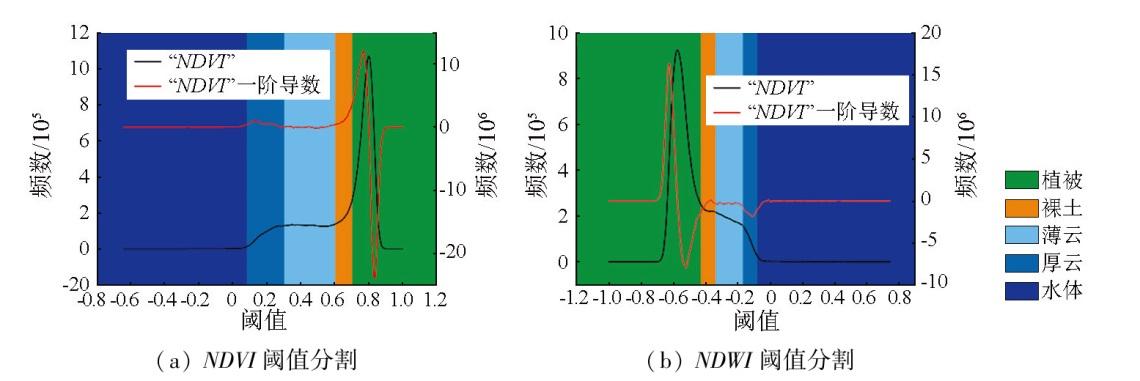
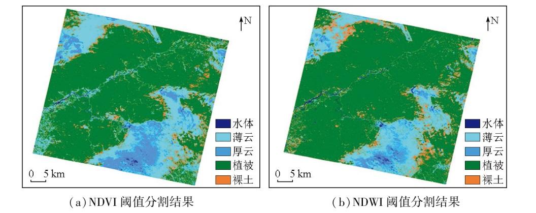
图4 基于NDVI和NDWI直方图阈值及其分割图像Fig.4 Histogram threshold and Image segmentation of NDVI and NDWI |
表1 NDVI和NDWI光谱指数分割阈值特征点Tab.1 Segmentation featwe points of threshold of NDVI and NDWI |
| 阈值特征分割 | 水体 | 厚云 | 薄云 | 裸土 | 植被 |
|---|---|---|---|---|---|
| NDVI阈值 | [-0.7, 0.08) | [0.08, 0.3) | [0.3, 0.6) | [0.6, 0.7) | [0.7, 1] |
| NDWI阈值 | [-0.08, 0.1) | [-0.17, -0.08) | [-0.34, -0.17) | [-0.43, -0.34) | [-1, -0.43] |
本文获得珠海欧比特宇航科技股份有限公司资助支持,在此表示衷心的感谢!
| [1] |
陈津乐, 张锦水, 段雅鸣, 等. 中分辨率遥感影像云检测与厚云去除研究综述[J]. 遥感技术与应用, 2023, 38(1):143-155.
|
| [2] |
|
| [3] |
朱照荣, 张锡越, 曾艳艳, 等. TBC 4.0软件下的长基线数据处理精度分析[J]. 测绘通报, 2018(4):146-149.
|
| [4] |
钟磊, 崔文刚, 敖德春, 等. 三种GPS基线处理软件的解算精度分析[J]. 测绘与空间地理信息, 2018, 41(2):90-93.
|
| [5] |
胡玉祥, 王智, 张洪德, 等. TBC和LGO在GNSS数据处理中的对比和应用研究[J]. 城市勘测, 2018(2):115-118.
|
| [6] |
张明波. 高分辨率遥感图像云检测方法研究[D]. 大连: 大连海事大学, 2018.
|
| [7] |
姬森展. 基于卷积神经网络的实时遥感图像云检测方法研究[D]. 哈尔滨: 哈尔滨工业大学, 2021.
|
| [8] |
杨彬, 郭金源, 何鹏, 等. 面向HY-1C卫星CZI陆地遥感图像的云检测方法研究[J]. 遥感学报, 2023, 27(1):55-67.
|
| [9] |
胡昌苗, 张正, 唐娉. 国产卫星多光谱数据云与云影检测算法研究[J]. 遥感学报, 2023, 27(3):623-634.
|
| [10] |
|
| [11] |
冯书谊, 张宁, 沈霁, 等. 基于反射率特性的高光谱遥感图像云检测方法研究[J]. 中国光学, 2015, 8(2):198-204.
|
| [12] |
赵晓, 侯晴宇, 梁冰冰, 等. 基于多属性融合的高分辨率遥感图像云检测方法[J]. 光学技术, 2014, 40(2):145-150.
|
| [13] |
徐冬宇, 厉小润, 赵辽英, 等. 基于光谱分析和动态分形维数的高光谱遥感图像云检测[J]. 激光与光电子学进展, 2019, 56(10):101003.
|
| [14] |
|
| [15] |
隋淞蔓, 夹尚丰, 胡学谦. 统一样本云检测技术在GF-6 WFV上的改进与应用[J]. 遥感学报, 2022, 26(4):646-56.
|
| [16] |
吴金亮. 国产高分多光谱数据的自动云检测[J]. 计算机与网络, 2015, 41(14):45-47.
|
| [17] |
高贤君, 万幼川, 郑顺义, 等. 航空摄影过程中云的实时自动检测[J]. 光谱学与光谱分析, 2014, 34(7):1909.
|
| [18] |
|
| [19] |
|
| [20] |
|
| [21] |
|
| [22] |
|
| [23] |
|
| [24] |
|
| [25] |
|
| [26] |
|
| [27] |
|
| [28] |
|
| [29] |
|
| [30] |
|
| [31] |
|
| [32] |
|
/
| 〈 |
|
〉 |