
Remote Sensing for Natural Resources >
Landslide identification based on an improved YOLOv7 model: A case study of the Baige area
Received date: 2024-03-21
Revised date: 2024-06-25
Online published: 2026-06-03
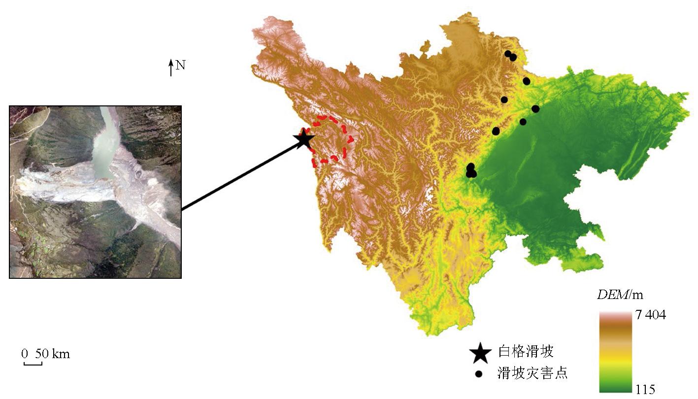
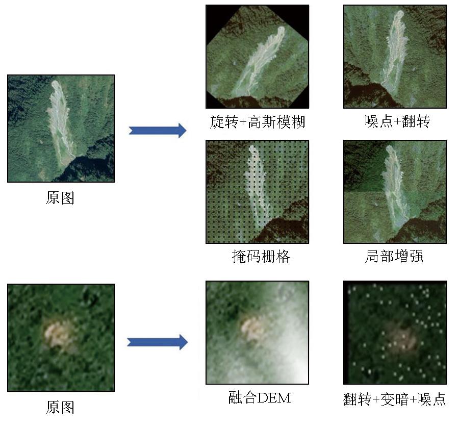
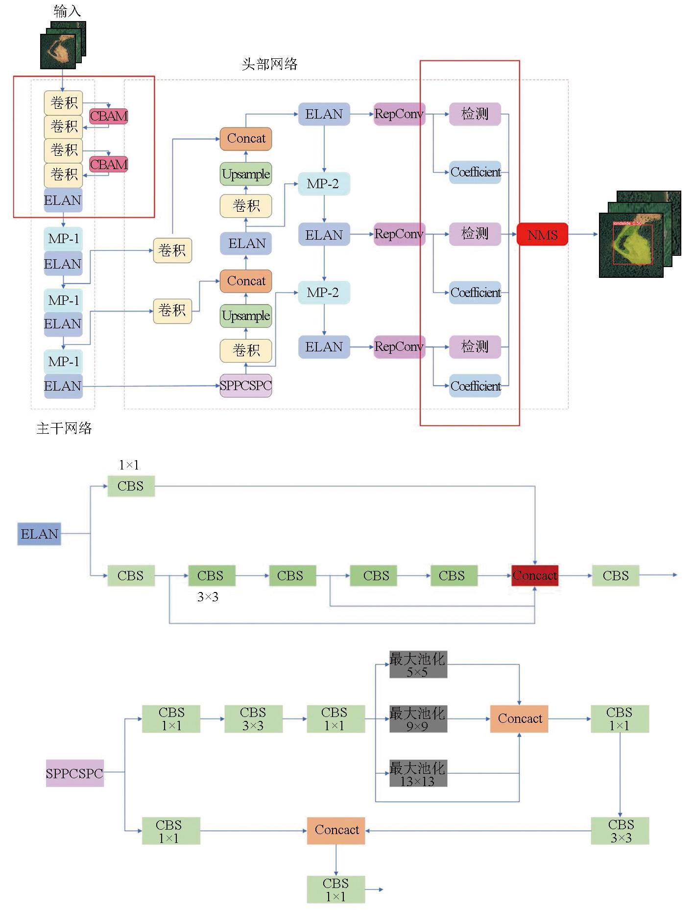
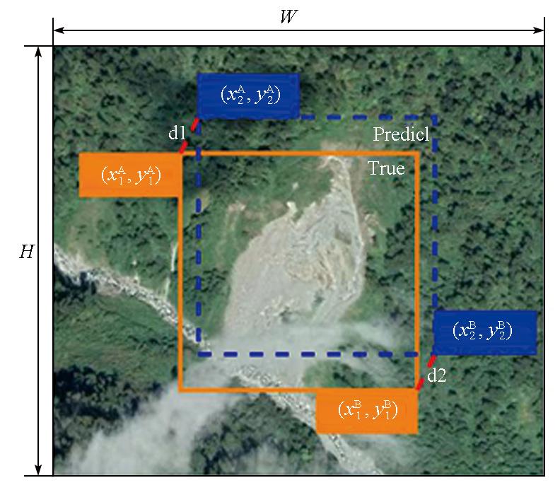
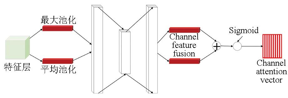
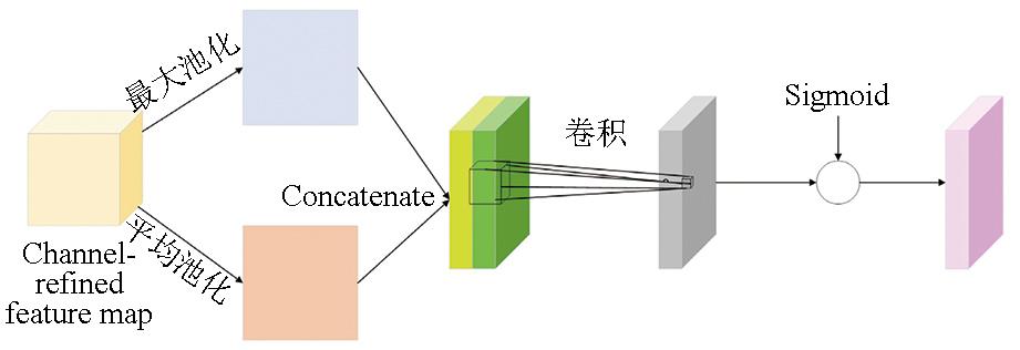
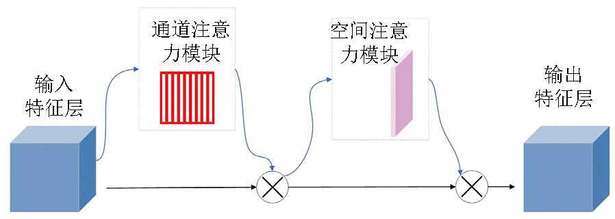
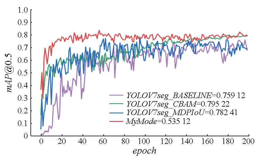
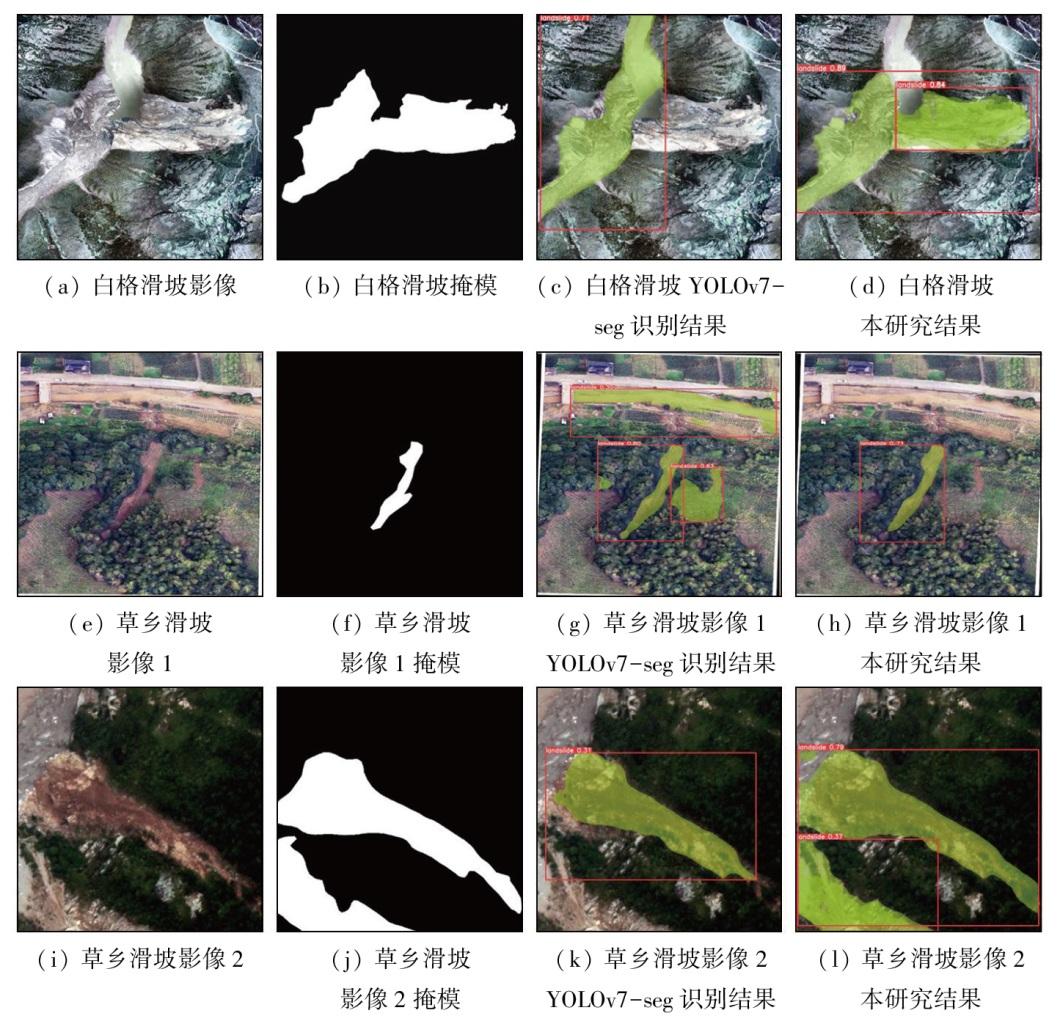
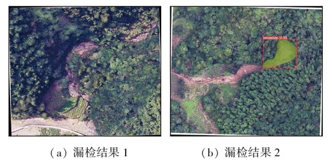
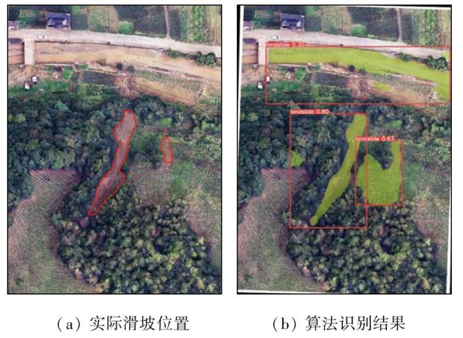
Landslide identification has always been a research topic in the study of geological disasters, playing a significant role in emergency rescue and command. To address the limitations in landslide identification, such as missed/false detection, and low identification accuracy, this study proposed an improved YOLOv7 model that enables simultaneous object detection and image segmentation for landslides. The improved model optimized its core network by integrating data, adding the convolutional block attention module (CBAM), and changing the intersection over union (IoU) loss function. Its effectiveness was verified using the landslide dataset of Bijie City, Guizhou Province, and the 0.2 m high-resolution digital orthophoto map (DOM) of historical landslides in Sichuan Province. The results indicate that the improved model performed well in landslide detection and segmentation, achieving more efficient and accurate landslide identification compared to the conventional YOLOv7 model, and other prevailing models like Fast RCNN and Mask RCNN. Taking the Baige area in Sichuan Province as an example, this model can effectively enhance the automation level of landslide disaster information acquisition while improving accuracy.
LIU Haoran , YAN Tianxiao , ZHU Yueqin , WANG Yanping , CHEN Zuyi , YANG Zhaoying , ZHU Haomeng . Landslide identification based on an improved YOLOv7 model: A case study of the Baige area[J]. Remote Sensing for Natural Resources, 2025 , 37(4) : 48 -57 . DOI: 10.6046/zrzyyg.2024110
表1 各项改进的消融实验Tab.1 Various improved ablation experiments |
| 模块 | 改进策略 | 精确率/% | 召回率/% | mAP@0.5/% | |||
|---|---|---|---|---|---|---|---|
| MPDIoU | CBAM | DEM | |||||
| YOLOv7-segment | 35.2 | 83.2 | 73.4 | 75.9 | |||
| YOLOv7-segment-A | √ | 36.3 | 84.7 | 74.5 | 78.2 | ||
| YOLOv7-segment-B | √ | 36.9 | 85.1 | 75.6 | 79.5 | ||
| YOLOv7-segment-C | √ | 35.2 | 86.3 | 76.1 | 78.2 | ||
| 本文方法 | √ | √ | √ | 37.9 | 89.4 | 79.8 | 83.5 |
表2 不同算法对比Tab.2 Comparison of different algorithms |
| 算法模型 | mAP@0.5/% | 参数量/MB | GFLOPs/GB |
|---|---|---|---|
| Mask R-CNN | 75.4 | 45.8 | 66.55 |
| YOLOv5L-seg | 75.9 | 46.56 | 109.60 |
| Faster-RCNN | 70.6 | 41.00 | 241.40 |
| YOLACT | 68.7 | 47.70 | 126.80 |
| YOLOv7-seg | 79.8 | 38.27 | 143.20 |
| 本文算法 | 83.5 | 37.89 | 141.50 |
| [1] |
谭永杰, 刘荣梅, 朱月琴, 等. 论地质大数据的特点与发展方向[J]. 时空信息学报, 2023, 30(3):313-320.
|
| [2] |
张潇远, 苏巧梅, 赵财胜, 等. 一种利用贝叶斯算法优化XGBoost的滑坡易发性评价方法[J]. 测绘科学, 2023, 48(6):140-150.
|
| [3] |
康孟羽, 朱月琴, 陈晨, 等. 基于多元非线性回归和BP神经网络的滑坡滑动距离预测模型研究[J]. 地质通报, 2022, 41(12):2281-2289.
|
| [4] |
洪韬, 朱月琴, 郭艳军, 等. 基于XR技术的交互式地质场景模型构建方法研究[J]. 地质通报, 2023, 42(s1):469-478.
|
| [5] |
|
| [6] |
|
| [7] |
|
| [8] |
|
| [9] |
|
| [10] |
|
| [11] |
|
| [12] |
杨昭颖, 韩灵怡, 郑向向, 等. 基于卷积神经网络的遥感影像及DEM滑坡识别——以黄土滑坡为例[J]. 自然资源遥感, 2022, 34(2):224-230.doi:10.6046/zrzyyg.2021204.
|
| [13] |
|
| [14] |
|
| [15] |
曾超, 曹振宇, 苏凤环, 等. 四川及周边滑坡泥石流灾害高精度航空影像及解译数据集(2008—2020年)[J]. 中国科学数据, 2022, 7(2):195-205.
|
| [16] |
黄震, 朱华波, 陶友瑞. 基于YOLOv5的打磨表面质量快速评价方法[J]. 智能计算机与应用, 2022, 12(11):247-252.
|
| [17] |
宋敏毓, 陈力荣, 梁建安, 等. 轻量化改进网络的实时光纤端面缺陷检测模型[J]. 激光与光电子学进展, 2022, 59(24):2415006.
|
| [18] |
|
| [19] |
|
| [20] |
|
| [21] |
|
/
| 〈 |
|
〉 |