
Remote Sensing for Natural Resources >
Design and implementation of a canoeing sport monitoring system with virtual-real interactions based on real-scene 3D
Received date: 2024-03-08
Revised date: 2024-05-10
Online published: 2026-06-03
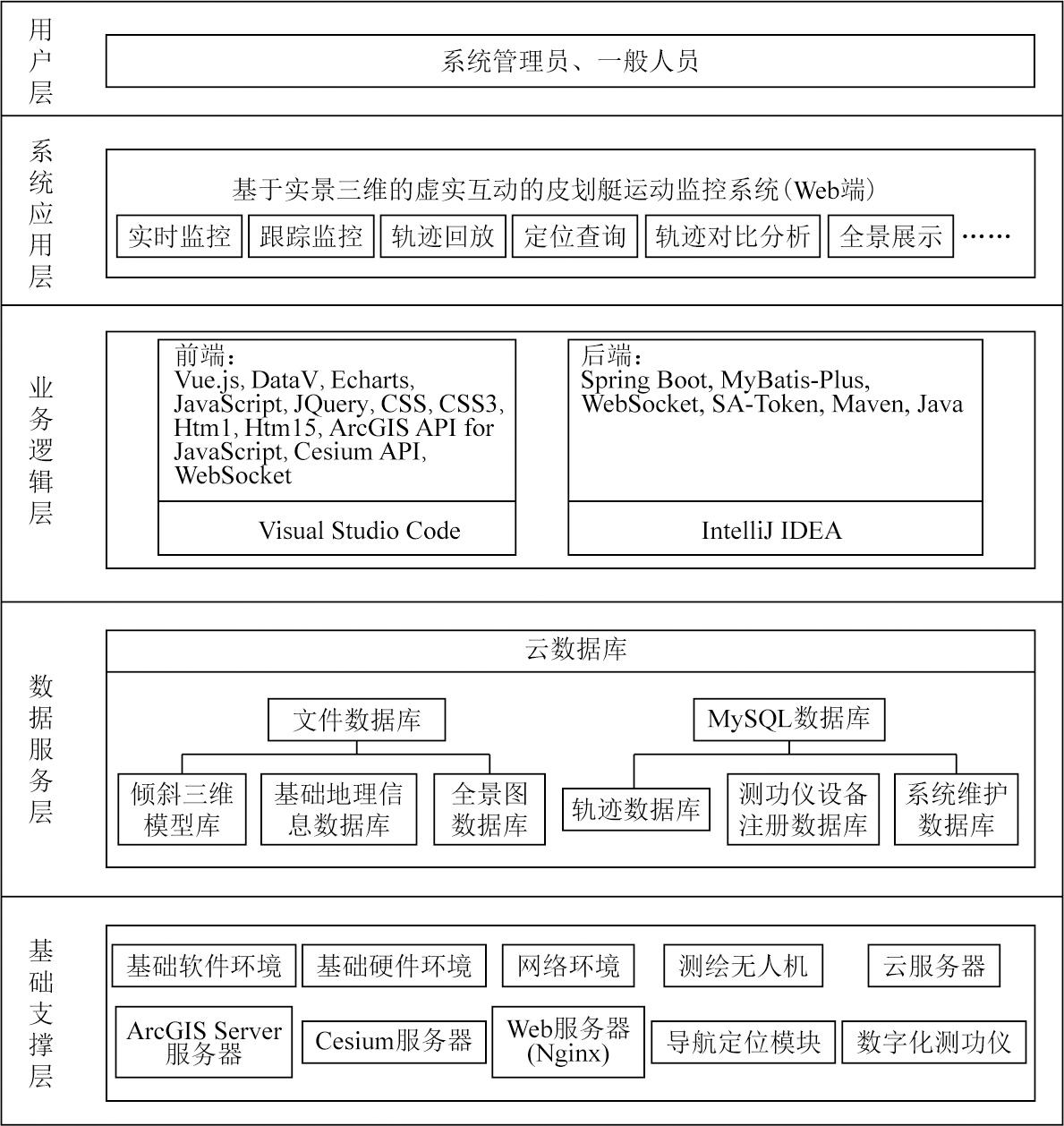
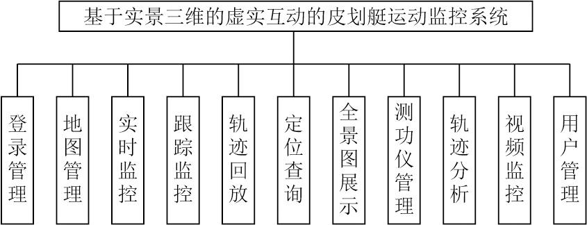
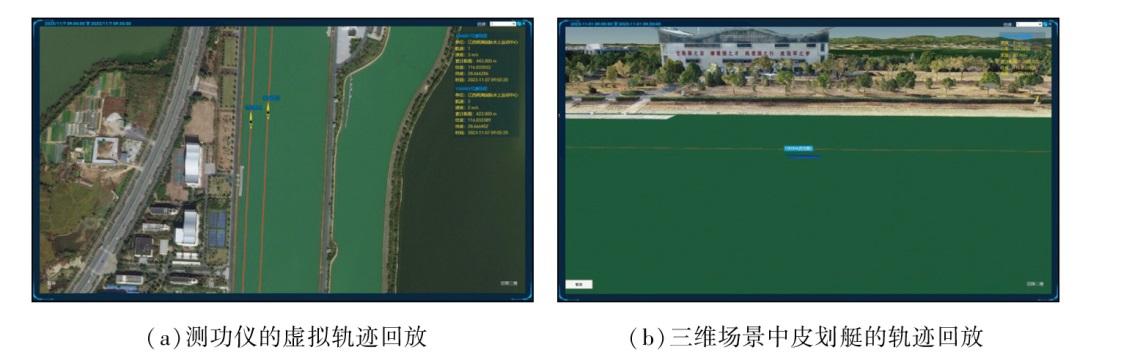
Canoeing is an important Olympic event; however, high-precision positioning and map data visualization technologies have not been widely adopted during the training phase of canoeing. To bridge this gap, this study proposed a domestically pioneering canoeing sport monitoring system based on real-scene 3D. This system integrates high-precision positioning, virtual reality (VR), and virtual-real fusion technologies, providing athletes and coaches with a straightforward, precise data analysis platform. First, this study presents an overview of the background and significance of the construction of the system. Then, it describes the architecture, major functions, and database design of the system. Finally, it introduces the software system development using technologies including the Cesium platform for 3D geospatial applications, ArcGIS Server, ArcGIS API for JavaScript, and WebSocket. The methods for developing key functions are also described. The core functions encompass 3D visualization of the training field, venue query and positioning, virtual-real integration of trajectories, real-time positioning and monitoring, trajectory playback, and data analysis. Therefore, this system enjoys the advances of high-precision positioning, 3D real scene visualization, and virtual-real fusion. The applications of this system will enhance the efficiency and quality of canoeing training and provide a valuable reference for related research fields.
WU Jianhua , KONG Xianglin , TU Haowen , GONG Zhigang , GUO Pengcheng . Design and implementation of a canoeing sport monitoring system with virtual-real interactions based on real-scene 3D[J]. Remote Sensing for Natural Resources, 2025 , 37(4) : 241 -248 . DOI: 10.6046/zrzyyg.2024090
表1 皮划艇实时数据表数据结构Tab.1 The data structure of canoeing real-time data table |
| 列名 | 数据类型 | 长度(位或 字符数) | 列说明 |
|---|---|---|---|
| id | int | 11 | 自增编号id,主键 |
| boat_no | varchar | 100 | 皮划艇编号 |
| status | int | 2 | 皮划艇状态 |
| boat_name | varchar | 100 | 皮划艇名称 |
| lon | double | — | 经度/(°) |
| lat | double | — | 纬度/(°) |
| height | double | — | 高程/m |
| distance | double | — | 累计距离(m) |
| speed | double | — | 速度(m/s) |
| stroke_rate | double | — | 桨频(次/min) |
| heart_rate | int | 3 | 心率(BPM) |
| create_time | datetime | — | 传入时间 |
表2 测功仪注册表数据结构Tab.2 The data structure of dynamometer registry |
| 列名 | 数据类型 | 长度(位或字符数) | 列说明 |
|---|---|---|---|
| deveice_id | bigint | 20 | 设备编号,主键 |
| unit | varchar | 150 | 设备所在单位 |
| place | varchar | 150 | 设备运行地点 |
| channel_no | int | 11 | 航道 |
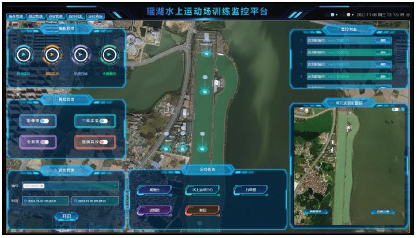
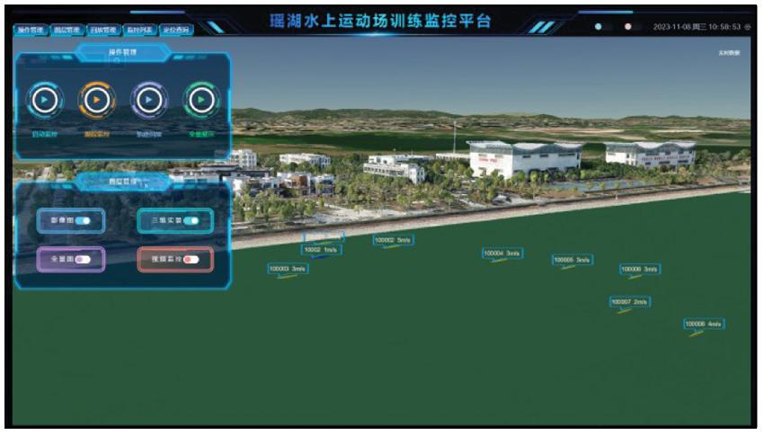
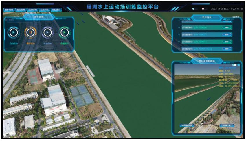
图4 基于三维场景的皮划艇定位监控界面Fig.4 Canoeing positioning monitoring interface based on 3D scene |
| [1] |
田中, 陈贵岐. 皮划艇项目的训练监控[J]. 沈阳体育学院学报, 2011, 30(5):87-90.
|
| [2] |
胡璞, 易名农, 刘嘉. 基于多传感器数据融合技术的水上训练监控系统的研制与应用[J]. 武汉体育学院学报, 2015, 49(3):96-100.
|
| [3] |
杜芸芸, 杨海英. 激流回旋视频监测系统研制[J]. 武汉体育学院学报, 2013, 47(10):77-80.
|
| [4] |
李媛, 史东林, 纪霄峰, 等. 皮划艇训练状态多参数遥测装置的研制[J]. 当代体育科技, 2014, 4(5):18-19.
|
| [5] |
孙晋海, 王家宏, 马运超, 等. 基于多传感器的皮划艇训练信息融合分析系统的研发与应用[J]. 北京体育大学学报, 2015, 38(5):115-121.
|
| [6] |
郝正东. 基于可穿戴计算的皮划艇技术动作识别与评价[D]. 大连: 大连理工大学, 2021.
|
| [7] |
徐红. 以新型基础测绘为支撑,走向更广阔的三维世界——访自然资源部国土测绘司司长武文忠[J]. 中国测绘, 2022(5):8-11.
|
| [8] |
|
| [9] |
陈洁, 蔡君, 李京, 等. 倾斜航空摄影技术及在地质调查中的应用研究——以三峡库区巫峡地区为例[J]. 国土资源遥感, 2021, 33(1):167-173.doi:10.6046/gtzyyg.2020133.
|
| [10] |
朱庆, 张利国, 丁雨淋, 等. 从实景三维建模到数字孪生建模[J]. 测绘学报, 2022, 51(6):1040-1049.
|
| [11] |
张广波. 面向倾斜实景模型的三维可视化平台建设技术研究[J]. 测绘通报, 2021(s1):277-281.
|
| [12] |
周勇帅. 基于Cesium框架实现倾斜摄影单体化的方法研究[D]. 成都: 成都理工大学, 2020.
|
/
| 〈 |
|
〉 |