
Remote Sensing for Natural Resources >
A spatial demarcation method for town areas: A case study of Xiapu County, Ningde City, Fujian
Received date: 2024-04-08
Revised date: 2024-06-25
Online published: 2026-06-03
Scientifically and rationally demarcating urban and town areas is a fundamental task during China’s rapid urbanization stage. It serves as a critical basis for promoting the optimization and quality improvement of urban and rural spaces, scientifically coordinating urban and rural planning and construction management, and implementing territorial spatial planning. However, there is neither a unified concept nor a universal delimitation method for urban and town areas in China, hindering their planning, construction, development, and public management. Based on defining the relevant concepts of urban and town areas, this study proposed a people-centered method for determining town areas with no cities and counties set using geographic information system (GIS) technology, considering the characteristics and spatial relationships of land types. The data sources of this study include the results of the third national land resource survey, statistical bulletins, remote sensing image interpretation, and point-of-interest (POI) data. Finally, the proposed method was applied to demarcate the town areas in Xiapu County, Ningde City. The empirical study results demonstrate the effectiveness of the proposed method, which features a scientific and concise technology roadmap and strong operability. Therefore, the proposed method can provide a theoretical foundation for the rational territorial spatial planning.
XU Yaoyao , WU Hanyu , YU Junjie , ZHU Yishu , WANG Jilong , PENG Bo . A spatial demarcation method for town areas: A case study of Xiapu County, Ningde City, Fujian[J]. Remote Sensing for Natural Resources, 2025 , 37(4) : 163 -172 . DOI: 10.6046/zrzyyg.2024130
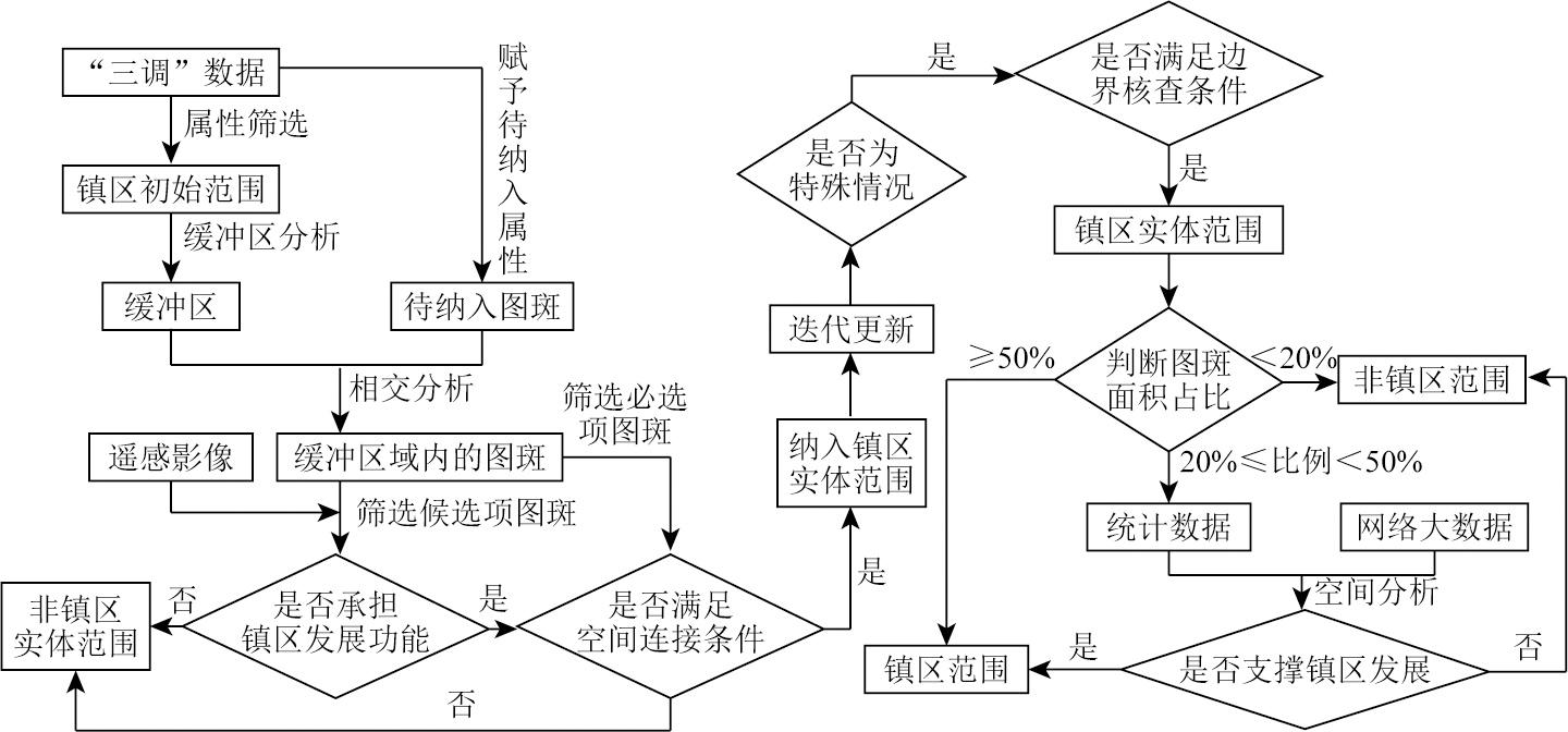
表1 图斑纳入标准Tab.1 Pattern definition criteria |
| 图斑用地类型 | 待纳入 项属性 | 是否纳入 实体范围 |
|---|---|---|
| 商业服务业(05),工业(0601),城市住宅(0701)和公共管理与公共服务(08),除管道运输外的交通运输 (10) | 必选项 | 做连接条件判断 |
| 湿地(00),林地(03),草地(04),农村宅基地(0702),特殊用地(09),管道运输(1009),水域及水利设施(11) | 候选项 | 待作支撑发展功能和连接条件判断 |
| 耕地(01),种植园(02),采矿(0602)和其他土地(12) | 剔除项 | 否 |
表2 镇区功能性界定标准Tab.2 Township functional definition standard |
| 类型 | 具备支撑发展功能性条件 |
|---|---|
| 湿地 | 具备公园功能或被镇区三面包围 |
| 林地 | 承担镇区生态涵养功能或被镇区三面包围 |
| 草地 | 具备休闲功能或被镇区三面包围 |
| 农村宅基地 | 具备镇区居住功能或被镇区三面包围 |
| 特殊用地 | 根据情况具体判断 |
| 管道运输 | 承担镇区居民生活必备物运输功能或被镇区三面包围 |
| 水域及水利设施 | 具备公园或承担镇区生态涵养功能或被镇区三面包围 |
表3 阻隔要素及连接条件Tab.3 Barrier elements and connection conditions |
| 阻隔要素 | 连接条件 |
|---|---|
| 河流 | 有桥梁、轮渡、隧道、涵洞,且可供行车辆行人顺利通行 |
| 铁路 | 有铁路道口、桥梁、隧道,且可供车辆行人顺利通行 |
| 高速公路 | 有桥梁、隧道,且可供车辆行人顺利通行 |
表4 特殊情况纳入及边界核查Tab.4 Boundary check standard |
| 图斑所属区域 | 是否纳入 实体范围 |
|---|---|
| 各级国家、省级开发区、工业园区、服务区已建成区 | 是 |
| 机场、火车站、港口等重要交通设施 | 是 |
| 其他不可替代的支撑镇区发展功能区域 | 是 |
| 划定县镇的行政范围外 | 否 |
| 生态保护红线内 | 否 |
| 永久基本农田界线内 | 否 |
| 超出镇区实体范围边界最外层居(村)委员会所辖区 | 否 |
| 独立且小的图斑 | 否 |
表5 设施功能范围Tab.5 Functional area of facility |
| 设施类型 | 设施种类 | 设施项目 | 服务功能覆盖标准 |
|---|---|---|---|
| 市政公 用设施 | 供电 | 变电站、电厂 | 全覆盖区域 |
| 供水排水 | 水厂、污水处理厂 | 全覆盖区域 | |
| 道路交通 | 公共交通站点 | 全覆盖区域 | |
| 消防 | 消防站、消防大队 | 3 km范围覆盖区域 | |
| 环境卫生 | 垃圾处理厂、垃圾转运站 | 全覆盖区域 | |
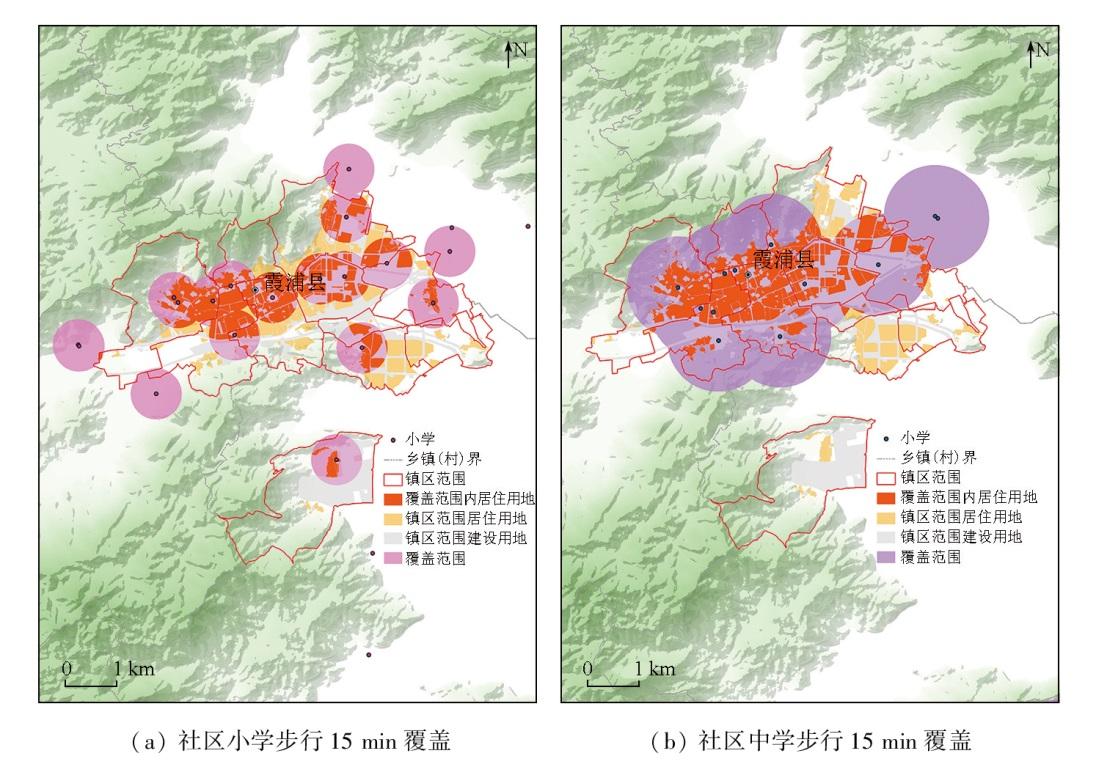
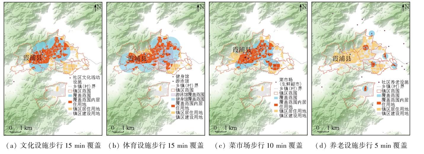
| 公共服 务设施 | 文化 | 各类活动中心、展览馆 | 1 km范围覆盖区域 |
| 教育 | 幼儿园、小学、中学 | 幼儿园: 300 m; 小学: 500 m; 中学: 1 km | |
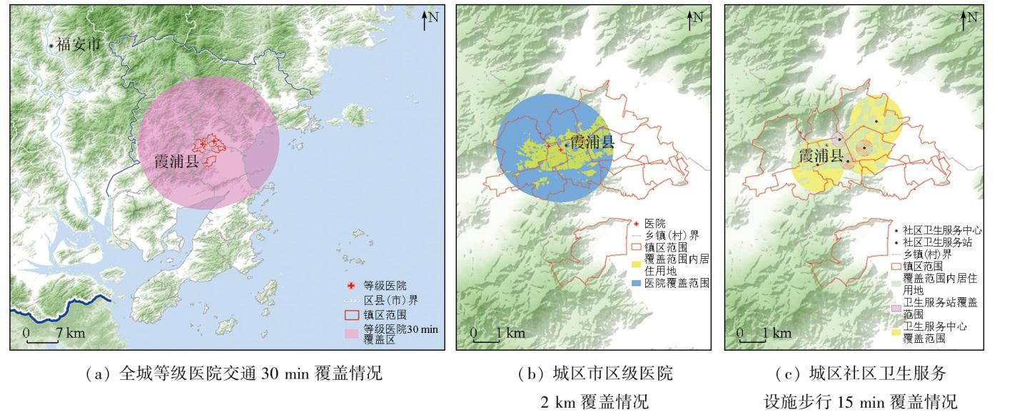
| 卫生 | 卫生服务设施、各级 医院 | 卫生服务站: 300 m; 卫生服务中心: 1 km; 等级医院: 15 km; 市区级医院: 2 km |
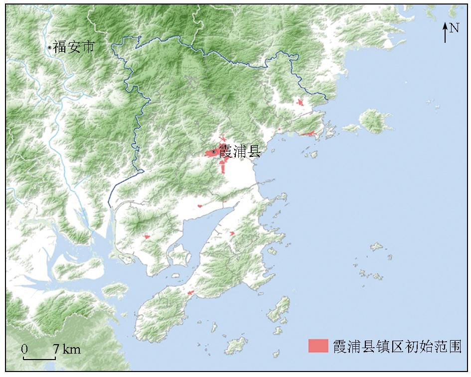
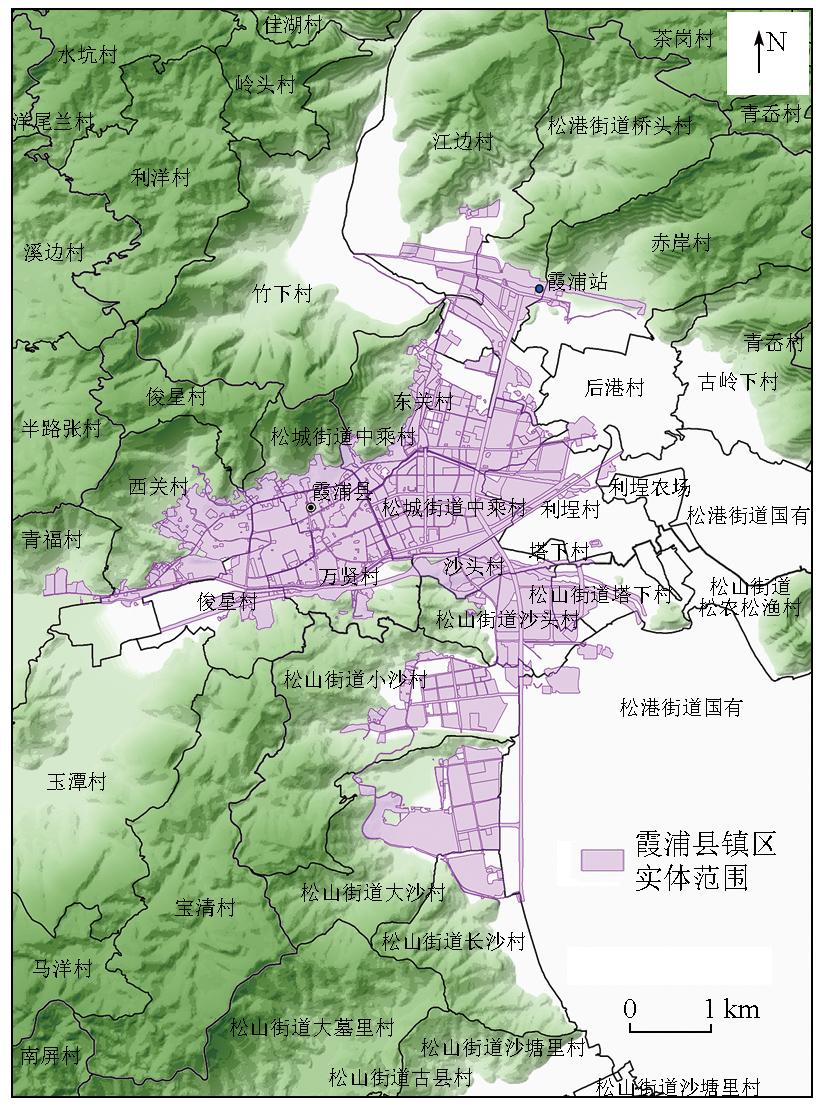
表6 镇区实体地域范围图斑统计表Tab.6 Scope map spot of township physical area |
| 序号 | 地类名称 | 图斑 数量 | 面积/m2 | 占比/% |
|---|---|---|---|---|
| 1 | 城镇住宅用地 | 171 | 555.18 | 36.62 |
| 2 | 工业用地 | 108 | 238.35 | 15.72 |
| 3 | 公路用地 | 62 | 183.61 | 12.11 |
| 4 | 城镇村道路用地 | 204 | 102.99 | 6.79 |
| 5 | 科教文卫用地 | 93 | 88.37 | 5.83 |
| 6 | 公园与绿地 | 34 | 79.22 | 5.23 |
| 7 | 商业服务业设施用地 | 139 | 69.82 | 4.60 |
| 8 | 农村宅基地 | 26 | 43.28 | 2.86 |
| 9 | 河流水面 | 45 | 30.30 | 2.00 |
| 10 | 铁路用地 | 3 | 29.13 | 1.92 |
| 11 | 其他草地 | 15 | 20.96 | 1.38 |
| 12 | 机关团体新闻出版用地 | 53 | 20.72 | 1.37 |
| 13 | 交通服务场站用地 | 27 | 16.53 | 1.09 |
| 14 | 特殊用地 | 30 | 10.45 | 0.69 |
| 15 | 物流仓储用地 | 19 | 7.38 | 0.49 |
| 16 | 公用设施用地 | 15 | 6.49 | 0.43 |
| 17 | 其他林地 | 15 | 5.90 | 0.39 |
| 18 | 乔木林地 | 5 | 2.50 | 0.16 |
| 19 | 水工建筑用地 | 7 | 1.78 | 0.12 |
| 20 | 竹林地 | 2 | 1.10 | 0.07 |
| 21 | 灌木林地 | 3 | 0.87 | 0.06 |
| 22 | 沟渠 | 2 | 0.51 | 0.03 |
| 23 | 坑塘水面 | 2 | 0.47 | 0.03 |
| 24 | 设施农用地 | 1 | 0.09 | 0.01 |
| 合计 | 1 081 | 1 516.00 | 100.00 | |
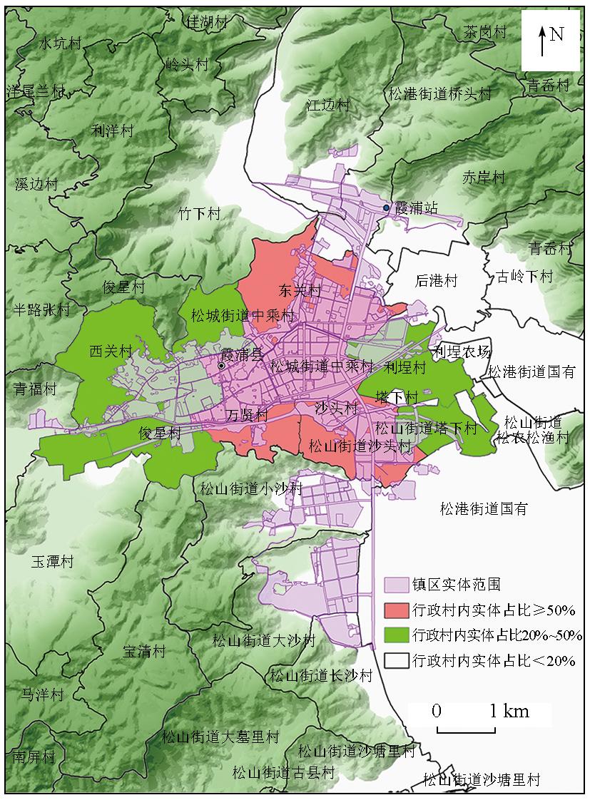
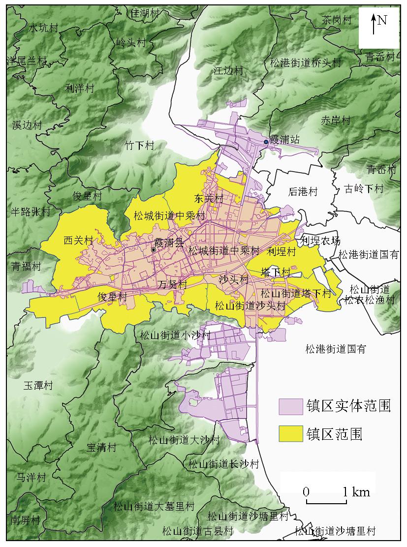
表7 镇区实体地域范围面积占比详情表Tab.7 Town physical area area proportion |
| 序号 | 居委会名称 | 面积占比 | 是否纳入 | 范围属性 | |
|---|---|---|---|---|---|
| 1 | 松港街道中乘村1 | 0.99 | 纳入镇区范围 | 镇区范围 | |
| 2 | 沙头村 | 0.85 | 纳入镇区范围 | 镇区范围 | |
| 3 | 万贤村 | 0.68 | 纳入镇区范围 | 镇区范围 | |
| 4 | 东关村 | 0.51 | 纳入镇区范围 | 镇区范围 | |
| 5 | 松山街道沙头村 | 0.51 | 纳入镇区范围 | 镇区范围 | |
| 6 | 俊星村 | 0.44 | 根据设施服务支撑功能判断 | 待判断范围 | |
| 7 | 松山街道大沙村 | 0.32 | 根据设施服务支撑功能判断 | 待判断范围 | |
| 8 | 利埕村 | 0.32 | 根据设施服务支撑功能判断 | 待判断范围 | |
| 9 | 西关村 | 0.29 | 根据设施服务支撑功能判断 | 待判断范围 | |
| 10 | 松城街道中乘村2 | 0.28 | 根据设施服务支撑功能判断 | 待判断范围 | |
| 11 | 松山街道塔下村 | 0.27 | 根据设施服务支撑功能判断 | 待判断范围 | |
| 12 | 其他 | <20 | 不纳入镇区范围 | 非镇区范围 | |
感谢宁德市自然资源局、霞浦县自然资源局提供“国土空间规划城市体检”项目工作并协调提供部分基础资料,中国地质调查局南京地质调查中心吴佳瑜、张艺武、张景、萧声隽、孙彦玮协助数据处理。
| [1] |
龙瀛, 吴康. 中国城市化的几个现实问题:空间扩张、人口收缩、低密度人类活动与城市范围界定[J]. 城市规划学刊, 2016,(2):72-77.
|
| [2] |
戚伟, 王开泳. 中国城市行政地域与实体地域的空间差异及优化整合[J]. 地理研究, 2019, 38(2):207-220.
|
| [3] |
汪阳. 我国城乡划分标准研究[D]. 成都: 西南交通大学, 2012.
|
| [4] |
衣霄翔, 董慰, 张欢. 美国城市地区划定方法及其演变对我国的启示[J]. 国际城市规划, 2021, 36(1):69-75.
|
| [5] |
周一星, 史育龙. 建立中国城市的实体地域概念[J]. 地理学报, 1995, 50(4):289-301.
|
| [6] |
惠彦, 金志丰, 陈雯. 城乡地域划分和城镇人口核定研究——以常熟市为例[J]. 地域研究与开发, 2009, 28(1):42-46.
|
| [7] |
宋小冬, 柳朴, 周一星. 上海市城乡实体地域的划分[J]. 地理学报, 2006, 61(8):787-797.
|
| [8] |
冯健. 城乡划分与监测[M]. 北京: 科学出版社, 2012.
|
| [9] |
徐强, 华晨. 城市建成区面积统计口径亟待统一——以杭州中心城区为例[J]. 规划师, 2005, 21(4):88-91.
|
| [10] |
华晨, 洪祎丹, 王颖芳, 等. 城镇建成区概念与界定方法体系研究——以浙江德清市武康镇为例[J]. 城市规划学刊, 2013(2):57-62.
|
| [11] |
胡忆东, 吴志华, 熊伟, 等. 城市建成区界定方法研究——以武汉市为例[J]. 城市规划, 2008, 32(4):88-91,96.
|
| [12] |
王浩, 刘娅菲, 宁晓刚, 等. 城区边界遥感提取研究进展[J]. 测绘科学, 2019, 44(6):159-165.
|
| [13] |
陈洪, 陶超, 邹峥嵘, 等. 一种新的高分辨率遥感影像城区提取方法[J]. 武汉大学学报(信息科学版), 2013, 38(9):1063-1067.
|
| [14] |
周婕, 陈虹桔, 谢波. 基于多元数据的大都市区范围划定方法研究——以武汉为例[J]. 上海城市规划, 2017(2):70-75.
|
| [15] |
|
| [16] |
|
| [17] |
周小驰, 刘咏梅, 杨海娟. 西安市城市边缘区空间识别与边界划分[J]. 地球信息科学学报, 2017, 19(10):1327-1335.
|
| [18] |
袁于评, 花益平, 薛星宇, 等. 多源遥感数据的城市边界提取及动态变化研究[J]. 测绘科学, 2022, 47(2):110-116.
|
| [19] |
王德, 顾家焕, 晏龙旭. 上海都市区边界划分——基于手机信令数据的探索[J]. 地理学报, 2018, 73(10):1896-1909.
|
| [20] |
方斌, 张宪哲, 杨柳. 基于POI数据的城市边界变化提取研究——以山西运城市城区为例[J]. 现代测绘, 2017, 40(5):20-22.
|
| [21] |
许泽宁, 高晓路. 基于电子地图兴趣点的城市建成区边界识别方法[J]. 地理学报, 2016, 71(6):928-939.
|
| [22] |
|
| [23] |
张欢, 赵志庆, 陈玉珠. 国土空间规划中城区范围划定方法、条件及流程初探——以江西省景德镇市为例[J]. 城市规划学刊, 2020(4):51-57.
|
| [24] |
徐浩, 王炜文. 新时期新规划体系下的镇区范围识别研究——以晋江市安海镇为例[C]// 中国城市规划学会.人民城市,规划赋能——2022中国城市规划年会论文集(20总体规划). 广州市: 广州市城市规划勘测设计研究院, 2023: 9.
|
| [25] |
国家统计局. 统计上划分城乡的规定[EB/OL]. https://www.stats.gov.cn/sj/tjbz/gjtjbz/202302/t20230213_1902742.html.
National Bureau of Statistics. Provisions for the statistical division of urban and rural areas[EB/OL]. https://www.stats.gov.cn/sj/tjbz/gjtjbz/202302/t20230213_1902742.html.
|
| [26] |
国家统计局. 城市(县城)和村镇建设统计调查制度[EB/OL]. https://www.stats.gov.cn/fw/bmdcxmsp/bmzd/202302/t20230215_1907097.html.
National Bureau of Statistics. Urban (county) and rural areas construction statistical survey system[EB/OL]. https://www.stats.gov.cn/fw/bmdcxmsp/bmzd/202302/t20230215_1907097.html.
|
| [27] |
国务院. 国务院关于调整城市规模划分标准的通知[EB/OL]. http://www.gov.cn/zhengce/content/2014-11/20/content_9225.htm.
The State Council. Notice of the State Council on readjustment of the standards for the division of urban dimensions[EB/OL]. http://www.gov.cn/zhengce/content/2014-11/20/content_9225.htm.
|
| [28] |
中华人民共和国建设部. GB/T 50280—1998 城市规划基本术语标准[S]. 北京: 中国建筑工业出版社, 1999.
Ministry of Construction of the People’s Republic of China. GB/T 50280—1998 Standard for basic terminology of urban planning[S]. Beijing: China Architecture Publishing, 1999.
|
| [29] |
中华人民共和国自然资源部. TD/T 1063—2021 国土空间规划城市体检评估规程[S]. 北京: 地质出版社, 2021.
Ministry of Natural Resources of the People’s Republic of China. TD/T 1063—2021 Code of practice for city examination & evaluation in spatial planning[S]. Beijing: Geological Publishing House, 2021.
|
| [30] |
王继龙, 林丰增, 彭博, 等. 东南沿海火山岩区城镇建设适宜性评价与实践——以福建省宁德市为例[J]. 华东地质, 2022, 43(4):490-502.
|
| [31] |
张定源, 张景, 牛晓楠, 等. 双评价理论探索与福建实践[J]. 华东地质, 2021, 42(4):419-428.
|
| [32] |
国务院第三次全国国土调查领导小组办公室. 国务院第三次全国国土调查领导小组办公室关于印发《第三次全国国土调查实施方案》的通知[EB/OL]. http://gi.mnr.gov.cn/201811/t20181120_2367135.html.
Office of the Third National Land Survey. Notice of the office of the third national land survey on the issuance of the implementation plan for the third national land survey[EB/OL]. http://gi.mnr.gov.cn/201811/t20181120_2367135.html.
|
| [33] |
中国国土勘测规划院, 自然资源部自然资源调查监测司.TD/T1055—2019 第三次全国国土调查技术规程[S]. 北京: 地质出版社, 2019.
Chinese Land Surveying and Planning Institute,Division of Natural Resources Survey and Monitoring,Ministry of Natural Resources. TD/T 1055—2019 Technical regulations for the third national land survey[S]. Beijing: Geological Publishing House, 2019.
|
| [34] |
林丰增. 新时期市级国土空间总体规划编制认识与思考——以福建省宁德市为例[J]. 华东地质, 2021, 42(4):409-418.
|
/
| 〈 |
|
〉 |