
Remote Sensing for Natural Resources >
Remote sensing monitoring and spatiotemporal variation analysis of vegetation cover under coal mining activities in the Shendong mining area from 1986 to 2023
Received date: 2024-01-23
Revised date: 2024-04-25
Online published: 2026-06-03
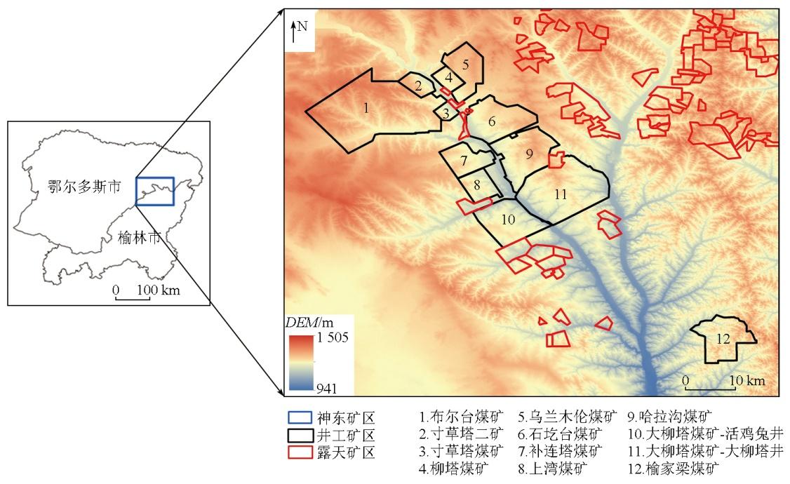
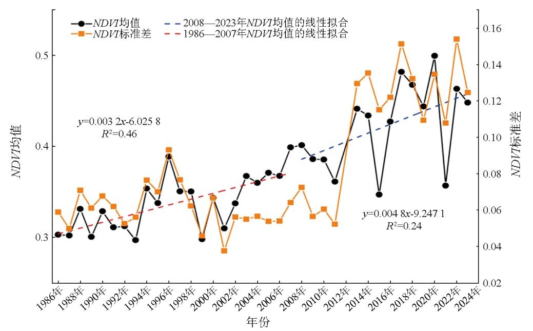
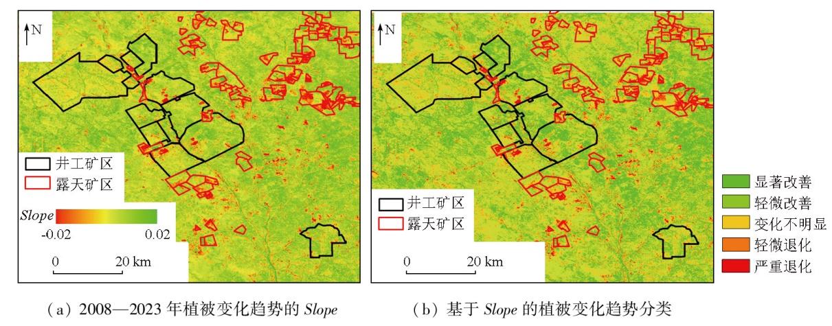
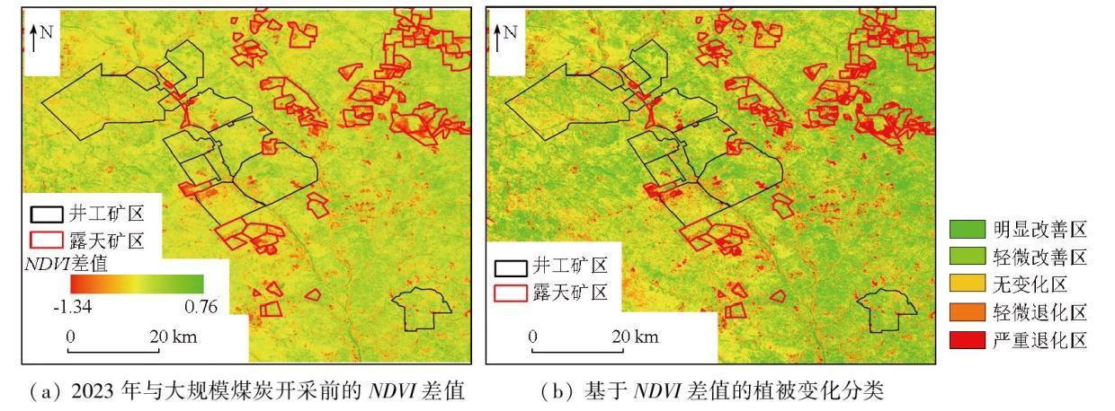
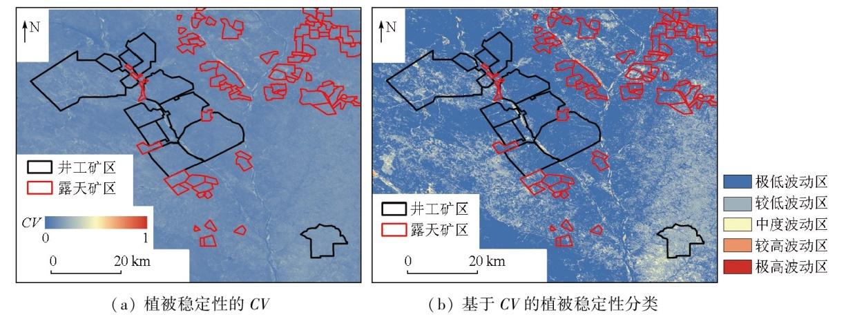
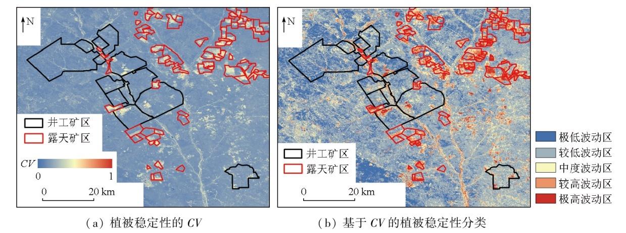
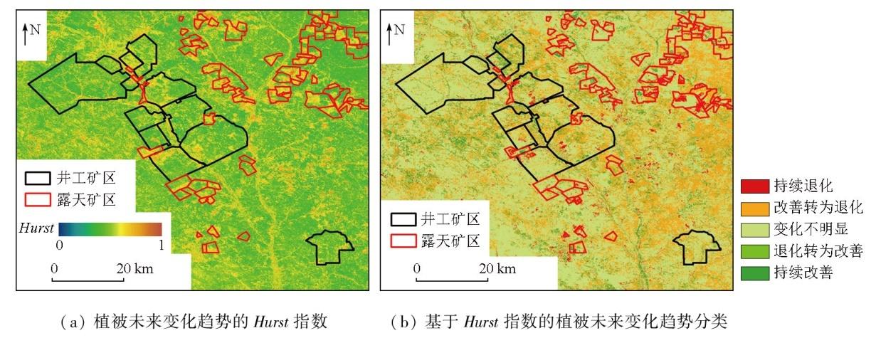
The Shendong mining area is a significant coal-producing area in China. Against the backdrop of climatic amelioration and large-scale coal mining, vegetation in the Shendong mining area has been influenced negatively by coal mining and positively by climatic amelioration and ecological restoration. Long time-series quantitative monitoring and assessment of vegetation cover in the mining area using remote sensing techniques play a significant role in local ecological quality management and ecological conservation. Based on Landsat satellite imagery data, this study conducted a long time-series monitoring of the normalized difference vegetation index (NDVI) in the Shendong mining area over a nearly 40-year period from 1986 to 2023. This monitoring focused on the interannual variations, variation trends, stability, and future variations of vegetation cover in the mining area. Moreover, this study performed a segmented quantitative analysis, taking 2008 (the onset of large-scale coal mining) as a demarcation point. The results indicate that climatic amelioration over the past nearly four decades has facilitated vegetation growth in the Shendong mining area. Despite the negative impacts of large-scale coal mining on surface vegetation, more favorable climatic conditions and ecological restoration efforts in the mining area have ensured a continuous improvement in vegetation cover, with a higher restoration rate observed locally. The Shendong mining area was characterized by improved vegetation cover across different stages,with the improved area exceeding 80 %. Large-scale coal mining caused limited vegetation deterioration, predominantly occurring in the open-pit mining area. In contrast, the vegetation restoration project in the underground mining area effectively ensured a favorable environment for vegetation growth. The vegetation cover in the Shendong mining area remained relatively stable at different stages. During large-scale coal mining, significant vegetation cover fluctuations occurred primarily in the stopes and waste dumps of the open-pit mining area. The underground mining area exhibited relatively stable vegetation cover overall, except for the land used for industrial and mining construction. Concerning future variations of vegetation cover, the Shendong mining area exhibited a relatively limited capability to maintain its current state. Due to large-scale mining activities, 3.92 % of the area underwent continuous degradation, which was primarily observed in the stopes of the open-pit mining area. This highlighted the urgent need for artificial ecological restoration in the stopes. The results of this study provide a reliable data reference for the supervision of ecological quality in the Shendong mining area, facilitating the more scientific and efficient establishment of a comprehensive ecological prevention and control system.
WANG Yi , ZHANG Yicong , CHENG Yang , XU Lianhang , GUO Junting , WANG Hui , LI Jun , DU Shouhang . Remote sensing monitoring and spatiotemporal variation analysis of vegetation cover under coal mining activities in the Shendong mining area from 1986 to 2023[J]. Remote Sensing for Natural Resources, 2025 , 37(3) : 65 -75 . DOI: 10.6046/zrzyyg.2024040
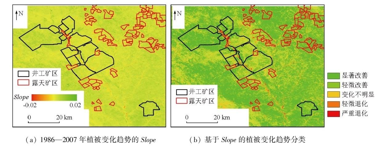
表1 显著性检验结果分级标准Tab.1 Classification rules of significance test results |
| 变化趋势 | 变化率 | 显著性水平 |
|---|---|---|
| 严重退化 轻微退化 | Slope<0 | a< 0.01 0.01 <a<0.05 |
| 变化不明显 | — | a> 0.05 |
| 轻微改善 明显改善 | Slope>0 | 0.01 <a<0.05 a< 0.01 |
| [1] |
李军, 彭苏萍, 张成业, 等. 矿区生态环境定量遥感监测评价技术框架与应用[J]. 矿业科学学报, 2022, 7(1):9-25,88.
|
| [2] |
张成业, 李军, 雷少刚, 等. 矿区生态环境定量遥感监测研究进展与展望[J]. 金属矿山, 2022(3):1-27.
|
| [3] |
岳辉, 刘英, 朱蓉. 基于遥感生态指数的神东矿区生态环境变化监测[J]. 水土保持通报, 2019, 39(2):101-107,114.
|
| [4] |
刘英, 雷少刚, 陈孝杨, 等. 神东矿区植被覆盖度时序变化与驱动因素分析及引导恢复策略[J]. 煤炭学报, 2021, 46(10):3319-3331.
|
| [5] |
徐佳, 王略, 王义, 等. 2000—2017年神东矿区植被NDVI时空动态[J]. 水土保持研究, 2021, 28(1):153-158.
|
| [6] |
李蕊, 陈国清, 李玮贤, 等. 基于遥感生态指数的神东矿区1995—2020年生态环境质量的时空变化特征分析[J]. 水土保持通报, 2021, 41(3):143-151.
|
| [7] |
李军, 彭传盈, 张成业, 等. 基于大样本的露天开采植被扰动范围一般性统计规律——以神东煤炭基地为例[J]. 煤炭学报, 2023, 48(2):975-985.
|
| [8] |
王小燕, 王丽云, 马宁. 神东矿区植被覆盖和土壤侵蚀时空动态分析[J]. 人民黄河, 2022, 44(5):124-127.
|
| [9] |
杨顺, 马超. 神东矿区GIMMS NDVI3g+(1982—2015)的时空变化及气候响应[C]// 中国煤炭学会土地复垦与生态修复专业委员会第八届全国矿区土地复垦与生态修复学术会议论文集.焦作, 2019:345-350.
|
| [10] |
|
| [11] |
牛鸿波, 田少国, 祖鹏举, 等. 神东矿区煤炭开采对植被净初级生产力的影响[J]. 煤炭科学技术, 2024, 52(7):267-277.
|
| [12] |
|
| [13] |
李向全, 马剑飞, 付昌昌. 神东煤炭基地1∶50 000活鸡兔幅矿区水文地质图数据集[J]. 中国地质, 2018, 45(s2):13-22,111-123.
|
| [14] |
王董董, 肖礼, 毕银丽, 等. 神东矿区接种AMF对植物-土壤生态化学计量及养分回收的影响[J]. 煤炭科学技术, 2024, 52(5):354-363.
|
| [15] |
|
| [16] |
李晶, 闫星光, 闫萧萧, 等. 基于GEE云平台的黄河流域植被覆盖度时空变化特征[J]. 煤炭学报, 2021, 46(5):1439-1450.
|
| [17] |
陈海喜, 钟九生, 兰安军, 等. 基于地形地貌因子的贵州省NDVI时空变化分析[J]. 贵州科学, 2019, 37(2):36-43.
|
| [18] |
王国芳, 毕如田, 张吴平, 等. 典型矿区植被覆盖度时空分布特征及影响因素[J]. 生态学报, 2020, 40(17):6046-6056.
|
| [19] |
|
| [20] |
李建飞, 李小兵, 周义. 2000—2015年乌兰察布市生长季NDVI时空变化及其影响因素[J]. 干旱区研究, 2019, 36(5):1238-1249.
|
| [21] |
|
| [22] |
代子俊, 赵霞, 李冠稳, 等. 基于GIMMS NDVI 3g. v1的近34年青海省植被生长季NDVI时空变化特征[J]. 草业科学, 2018, 35(4):713-725.
|
| [23] |
|
| [24] |
张华, 安慧敏. 基于GEE的1987—2019年民勤绿洲NDVI变化特征及趋势分析[J]. 中国沙漠, 2021, 41(1):28-36.
|
| [25] |
钟红平, 王宏志. 2007年-2016年湖北省归一化植被指数时空变化特征分析[J]. 华中师范大学学报(自然科学版)
|
| [26] |
龙爽, 郭正飞, 徐粒, 等. 基于Google Earth Engine的中国植被覆盖度时空变化特征分析[J]. 遥感技术与应用, 2020, 35(2):326-334.
|
| [27] |
康帅直, 穆琪, 赵永华, 等. 黄土高原神府资源开采区生态环境质量时空格局特征[J]. 生态学报, 2023, 43(7):2781-2792.
|
| [28] |
|
| [29] |
胡振琪. 我国土地复垦与生态修复30年:回顾、反思与展望[J]. 煤炭科学技术, 2019, 47(1):25-35.
|
| [30] |
李全生, 贺安民, 曹志国. 神东矿区现代煤炭开采技术下地表生态自修复研究[J]. 煤炭工程, 2012, 44(12):120-122.
|
| [31] |
谷海静. 西部脆弱矿区绿色开采技术发展现状及方向[J]. 陕西煤炭, 2022, 41(5):222-225.
|
| [32] |
徐清清. 神东矿区生态治理技术评价研究[D]. 徐州: 中国矿业大学, 2022.
|
| [33] |
杨俊哲, 陈苏社, 王义, 等. 神东矿区绿色开采技术[J]. 煤炭科学技术, 2013, 41(9):34-39.
|
| [34] |
刘海平, 王义. 神东矿区资源环境治理对策研究及其具体实践[J]. 中国煤炭, 2023, 49(s1):6-14.
|
/
| 〈 |
|
〉 |