
Remote Sensing for Natural Resources >
Predicting surface subsidence in large-scale mining areas based on time-series InSAR and the IRIME-LSTM model
Received date: 2024-02-02
Revised date: 2024-08-23
Online published: 2026-06-03
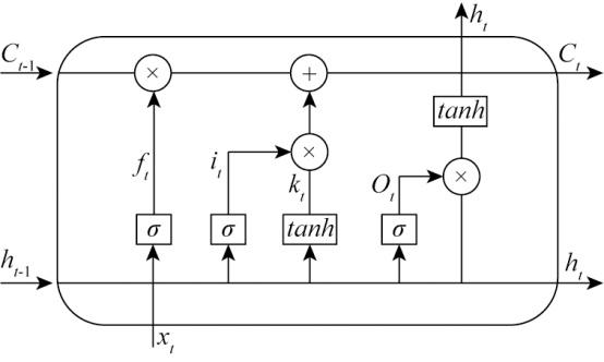
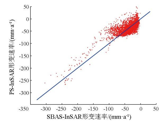
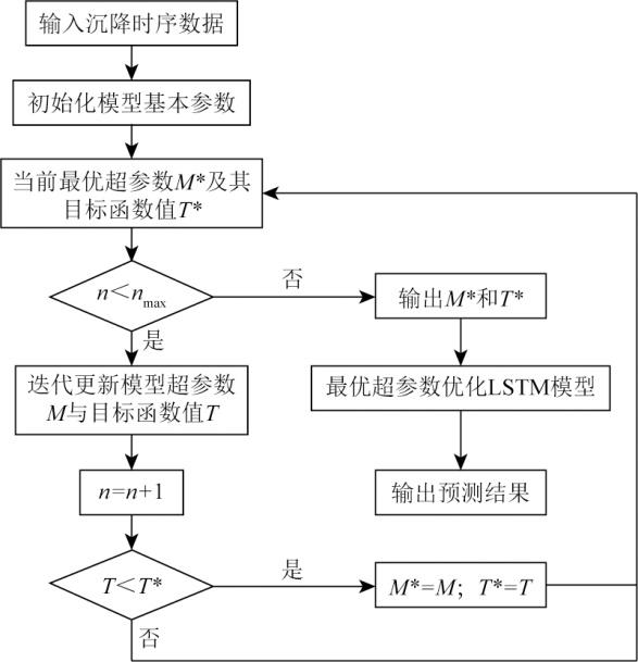
Interferometric synthetic aperture Radar (InSAR) technology serves as a significant approach for analyzing surface subsidence in large-scale mining areas. Accurately predicting surface subsidence plays a significant role in preventing geological disasters. The long short-term memory (LSTM) network model faces challenges in parameter selection, while the rime optimization algorithm (RIME) is susceptible to local optimum and dependence on the initial solution. Considering these challenges, this study proposed a surface subsidence prediction model with LSTM optimized by the improved rime optimization algorithm (IRIME). The IRIME incorporated chaotic mapping, the improved Lévy flight mechanism, and the global exploration strategy of the hunter-prey optimizer (HPO). The proposed model is also referred to as the IRIME-LSTM model. With the Honghui coal mine as the study area, this study obtained the subsidence time series of highly coherent points in the mining area using small baseline subset (SBAS)-InSAR technology. Subsequently, this study conducted multi-step predictions of these highly coherent points using the IRIME-LSTM model, with the prediction results compared with the InSAR monitoring data. The results of this study indicate that the IRIME-LSTM model yielded a root mean square error (RMSE) of 2.65 mm, a mean absolute error (MAE) of 1.59 mm, and a mean absolute percentage error (MAPE) of 3.92 % in the overall test set. Compared to the RIME-LSTM and GS-LSTM models, the IRIME-LSTM model reduced the RMSE by 37.20 % and 51.73 %, the MAE by 42.60 % and 56.32 %, and the MAPE by 35.63 % and 50.51 %, respectively, demonstrating its high reliability and feasibility.
CEHN Lanlan , FAN Yongchao , XIAO Haiping , WAN Junhui , CHEN Lei . Predicting surface subsidence in large-scale mining areas based on time-series InSAR and the IRIME-LSTM model[J]. Remote Sensing for Natural Resources, 2025 , 37(3) : 245 -252 . DOI: 10.6046/zrzyyg.2024048
表1 IRIME-LSTM模型训练参数Tab.1 Training parameter of IRIME-LSTM model |
| 参数名称 | 说明 | 参数名称 | 说明 |
|---|---|---|---|
| 种群大小 | 10 | 训练最大轮数 | 100 |
| 最大迭代次数 | 30 | 小批量样本数 | 128 |
| 失活率 | 0.2 | 学习率减小因子 | 0.1 |
| 数据打乱 | Every-epoch | 训练方法 | Adam |
表2 模型最优参数Tab.2 Optimal parameters of models |
| 模型 | 初始学 习率R | 隐藏层 节点数S | 网络 层数K | 样本 长度L |
|---|---|---|---|---|
| IRIME-LSTM | 0.071 861 | 14 | 2 | 20 |
| RIME-LSTM | 0.085 731 | 89 | 2 | 21 |
| GS-LSTM | 0.005 154 | 40 | 3 | 22 |
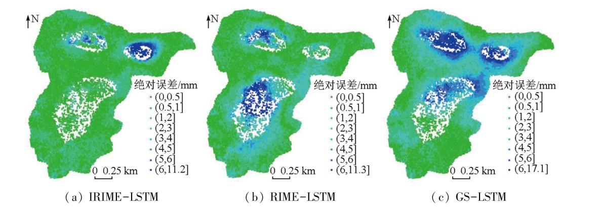
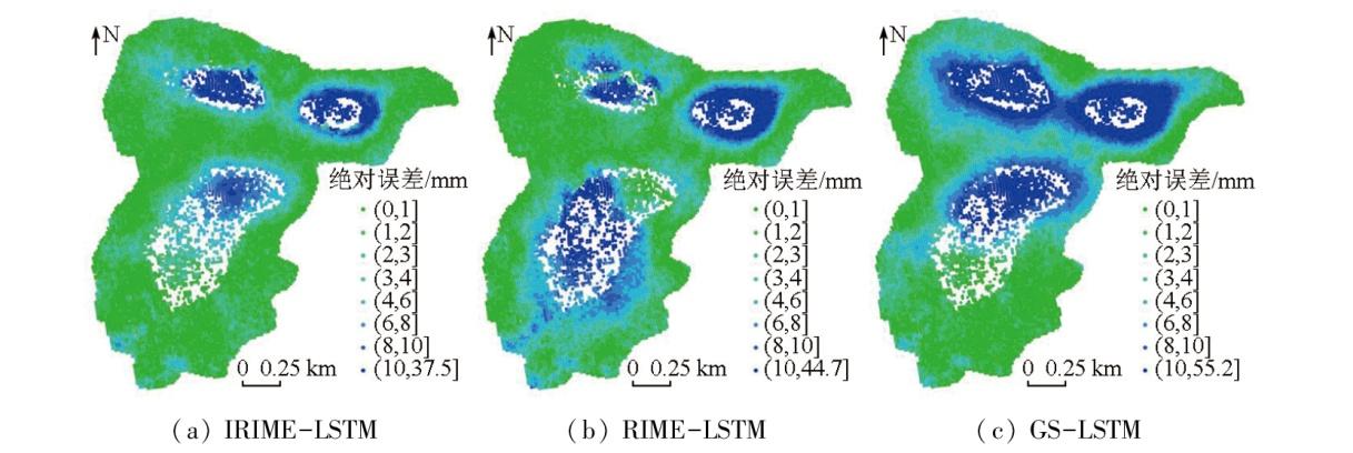
图8 不同模型单步预测的绝对误差空间分布Fig.8 Spatial distribution of absolute errors in single step prediction for different models |
图9 不同模型第7步预测的绝对误差空间分布Fig.9 Spatial distribution of absolute errors in the seventh step of prediction for different models |
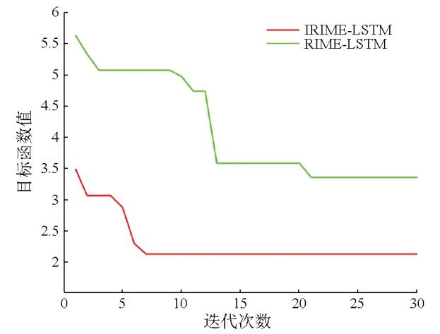
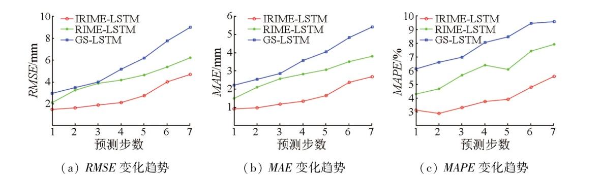
图10 不同模型的性能评价指标变化趋势Fig.10 Trend of performance evaluation indicators for different models |
表3 单步预测的绝对误差具体分类及占比Tab.3 Specific classification and its proportion of absolute error in single step prediction |
| 绝对误差区间/mm | IRIME-LSTM | RIME-LSTM | GS-LSTM | |||
|---|---|---|---|---|---|---|
| 高相干点数 | 所占比例/% | 高相干点数 | 所占比例/% | 高相干点数 | 所占比例/% | |
| (0,2] | 11 280 | 92.62 | 9 010 | 73.98 | 6 594 | 54.14 |
| (2,4] | 551 | 4.52 | 2 439 | 20.03 | 3 770 | 30.96 |
| (4,6] | 184 | 1.51 | 434 | 3.56 | 1 339 | 10.99 |
| >6 | 164 | 1.35 | 296 | 2.43 | 476 | 3.91 |
表4 第7步预测的绝对误差具体分类及占比Tab.4 Specific classification and its proportion of absolute error in the seventh step of prediction |
| 绝对误差区间/mm | IRIME-LSTM | RIME-LSTM | GS-LSTM | |||
|---|---|---|---|---|---|---|
| 高相干点数 | 所占比例/% | 高相干点数 | 所占比例/% | 高相干点数 | 所占比例/% | |
| (0,2] | 7 501 | 61.59 | 5 646 | 46.36 | 4 469 | 36.69 |
| (2,4] | 2 638 | 21.66 | 2 985 | 24.51 | 2 897 | 23.79 |
| (4,6] | 831 | 6.82 | 1 395 | 11.45 | 1 502 | 12.33 |
| >6 | 1 209 | 9.93 | 2 153 | 17.68 | 3 311 | 27.19 |
| [1] |
李想, 焦玉勇, 邹俊鹏, 等. 深部采煤覆岩移动和地表沉降研究[J]. 安全与环境工程, 2022, 29(2):32-38,56.
|
| [2] |
顿志林, 王文唱, 邹友峰, 等. 基于时间函数组合模型的采空区地表沉降动态预测及剩余变形计算[J]. 煤炭学报, 2022, 47(s1):13-28.
|
| [3] |
徐子兴, 季民, 张过, 等. 基于SBAS-InSAR技术和Logistic模型的矿区沉降动态预测方法[J]. 自然资源遥感, 2022, 34(2):20-29.doi:10.6046/zrzyyg.2021354.
|
| [4] |
谭志祥, 杨嘉威, 邓喀中. 基于SBAS-InSAR的矿区全盆地开采沉陷求参方法研究[J]. 煤炭科学技术, 2021, 49(1):312-318.
|
| [5] |
|
| [6] |
|
| [7] |
麻源源, 陈云波, 左小清, 等. Sentinel-1A数据及短基线集的昆明地面沉降分析[J]. 测绘科学, 2019, 44(11):59-66,95.
|
| [8] |
|
| [9] |
杨帆, 胡晋, 孙彩霞. InSAR技术结合深度学习的范围性地表沉降预测[J]. 测绘科学, 2022, 47(7):60-68,134.
|
| [10] |
刘青豪, 张永红, 邓敏, 等. 大范围地表沉降时序深度学习预测法[J]. 测绘学报, 2021, 50(3):396-404.
|
| [11] |
周文韬, 张文君, 杨元继, 等. 矿区地表沉降监测的一种组合模型预测方法[J]. 大地测量与地球动力学, 2021, 41(3):308-312.
|
| [12] |
岳振华, 沈涛, 毛曦, 等. 循环神经网络的地面沉降预测方法[J]. 测绘科学, 2020, 45(12):145-152.
|
| [13] |
师芸, 李杰, 吕杰, 等. 结合SBAS-InSAR与支持向量回归的开采沉陷监测与预测[J]. 遥感信息, 2021, 36(2):6-12.
|
| [14] |
鄢涛, 陈波, 曹恩华, 等. 基于EEMD-ELM的大坝变形预测模型[J]. 长江科学院院报, 2020, 37(11):70-73,80.
|
| [15] |
|
| [16] |
|
| [17] |
葛唱, 钱素琴. 改进麻雀搜索算法的无人车路径规划[J]. 导航定位学报, 2022, 10(6):107-111.
|
| [18] |
|
| [19] |
肖海平, 夏益强, 刘小生, 等. 融合SBAS-InSAR技术与TSO-LSTM模型的矿区地表沉降预测方法[J]. 金属矿山, 2023(1):126-133.
|
| [20] |
刘青豪, 刘慧敏, 张永红, 等. 顾及空间异质性的大范围地面沉降时空预测[J]. 遥感学报, 2022, 26(7):1315-1325.
|
| [21] |
刘宝宝, 杨菁菁, 陶露, 等. 基于DE-LSTM模型的教育统计数据预测研究[J]. 计算机科学, 2022, 49(s1):261-266.
|
/
| 〈 |
|
〉 |