
Remote Sensing for Natural Resources >
Monitoring and analysis of new mining-destroyed land and land restoration and management in Shandong Province in 2021
Received date: 2023-08-28
Revised date: 2024-01-03
Online published: 2026-06-03
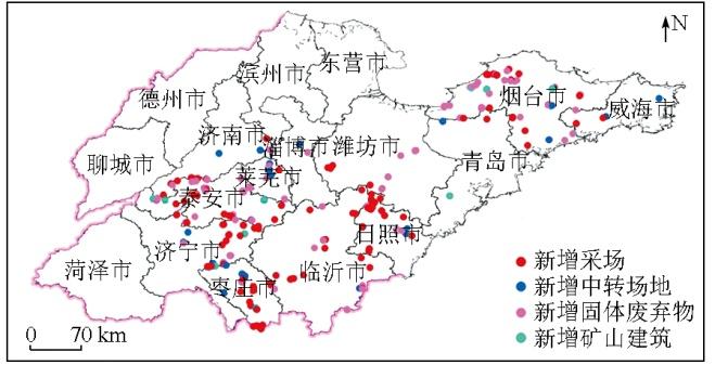
Timely and accurate monitoring and analysis of land for mine development and associated restoration and management is a principal task in remote sensing survey and monitoring of mine environments. Hence, using high-spatial-resolution remote sensing data as primary data source, this study delineated the new mining-destroyed land area (558.07 hm2) and land restoration and management area (1 019.07 hm2, including artificially restored 975.29 hm2 and naturally restored 43.78 hm2) in Shandong Province in 2021. Additionally, there were 26.59 hm2 of destroyed land due to infrastructure and road construction and 77.03 hm2 of tailings pond management. By preliminarily analyzing the remote sensing work concerning the new mining-destroyed land and land restoration and management in Shandong Province in 2021, this study proposed countermeasures and suggestions for existing problems. The investigation and monitoring results can effectively support the scientific decision-making of land management departments in Shandong Province.
ZHAO Lijun , LIU Huan , ZHANG Yun , YANG Junquan , WANG Wei , CHEN Donglei . Monitoring and analysis of new mining-destroyed land and land restoration and management in Shandong Province in 2021[J]. Remote Sensing for Natural Resources, 2025 , 37(3) : 17 -22 . DOI: 10.6046/gtzyyg.2023399
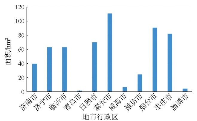
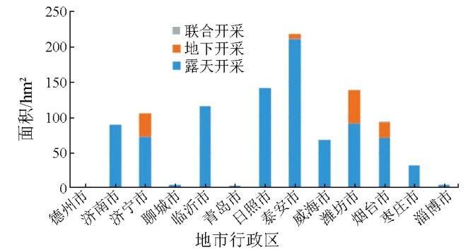
表1 山东省新增矿山恢复治理面积统计Tab.1 Area statistics of new mine restoration and treatment in Shandong Province in 2021 (hm2) |
| 地级行政区 | 工程恢复治理 | 自然恢复 | 连带恢复 | 合计 |
|---|---|---|---|---|
| 泰安市 | 219.11 | 0.04 | — | 219.15 |
| 日照市 | 135.16 | — | 6.37 | 141.53 |
| 潍坊市 | 139.65 | — | — | 139.65 |
| 临沂市 | 111.45 | — | 4.98 | 116.43 |
| 济宁市 | 105.38 | — | — | 105.38 |
| 烟台市 | 91.86 | 0.95 | — | 92.81 |
| 济南市 | 48.52 | 41.56 | — | 90.08 |
| 威海市 | 68.04 | — | — | 68.04 |
| 枣庄市 | 31.13 | — | 1.20 | 32.33 |
| 聊城市 | 5.05 | — | — | 5.05 |
| 淄博市 | 4.77 | — | — | 4.77 |
| 青岛市 | 1.61 | 1.23 | — | 2.83 |
| 德州市 | 1.01 | — | — | 1.01 |
| 合计 | 962.74 | 43.78 | 12.55 | 1 019.07 |
表2 山东省2018—2021年矿山新增损毁和恢复治理统计表Tab.2 Area statistics of new mining-destroyed land and restoration in Shandong Province in 2018—2021(hm2) |
| 矿山 | 2018年 | 2019年 | 2020年 | 2021年 |
|---|---|---|---|---|
| 采场 | 596.23 | 415.91 | 258.79 | 343.04 |
| 中转场地 | 141.03 | 119.01 | 44.91 | 129.74 |
| 固体废弃物 | 226.21 | 152.59 | 22.16 | 79.50 |
| 矿山建筑 | 7.56 | 2.98 | 2.84 | 5.79 |
| 恢复治理 | 5 245.50 | 1 652.75 | 1 873.84 | 1 019.07 |
| [1] |
杨金中, 许文佳, 姚维岭, 等. 全国采矿损毁土地分布与治理状况及存在问题[J]. 地学前缘, 2021, 28(4):83-89.
|
| [2] |
杨金中, 秦绪文, 聂洪峰, 等. 全国重点矿区矿山遥感监测综合研究[J]. 中国地质调查, 2015, 2(4):24-30.
|
| [3] |
|
| [4] |
柴永昌. 山东省几种优势非金属矿产的开发利用现状及其发展前景[J]. 山东地质, 1999, 15(4):50-55.
|
| [5] |
|
| [6] |
|
| [7] |
刘欢, 张云, 黄旭红, 等. 遥感技术在内蒙古自治区中西部重点矿区开采监测中的应用[J]. 华北地质, 2021, 44(4):55-60.
|
| [8] |
梁晖, 杨士道. 遥感技术在蓟县北部矿山开采动态监测中的应用[J]. 地质调查与研究, 2005, 28(3):180-186.
|
| [9] |
马霭乃. 遥感目视解译的基本理论与方法[J]. 遥感信息, 1987, 2(3):26-29.
|
| [10] |
|
| [11] |
黄登冕, 张聪, 姚晓军, 等. 矿山环境遥感监测研究进展[J]. 遥感技术与应用, 2022, 37(5):1043-1055.
|
| [12] |
王建华, 李阳, 梁树能, 等. 基于高光谱卫星数据的土地沙化识别及提取研究[J]. 华北地质, 2022(4):60-67.
|
| [13] |
高俊华, 邹联学, 龙欢, 等. 基于遥感动态监测的吉林省矿山地质环境及生态修复变化特征分析[J]. 自然资源遥感, 2022, 34(3):240-248.doi:10.6046/zrzyyg.2021278.
|
| [14] |
唐静秋. 浅析遥感信息技术在自然资源监测监管中的应用[J]. 测绘与空间地理信息, 2022, 45(10):38-40.
|
| [15] |
祁帅, 乔文光, 张勇. 遥感技术在内蒙古绿色矿山地质环境动态监测中的应用[J]. 测绘通报, 2021(s1):79-82.
|
| [16] |
中华人民共和国国土资源部. DZ/T 0266—2014 矿产资源开发遥感监测技术规范[S]. 北京: 中国标准出版社, 2014.
Ministry of Land and Resurces of the People’s Republic of China. DZ/T 0266—2014 Regulation on remote sensing monitoring of mining exploration[S]. Beijing: Standards Press of China, 2014.
|
| [17] |
修晓龙. 山西省矿山开发新增损毁土地年度监测与分析[J]. 中国矿业, 2022, 31(2):59-64.
|
/
| 〈 |
|
〉 |