
Remote Sensing for Natural Resources >
Remote sensing identification of industrial solid waste and open pits in mining areas based on the multiscale sample set optimization strategy
Received date: 2023-12-19
Revised date: 2024-04-09
Online published: 2026-06-03
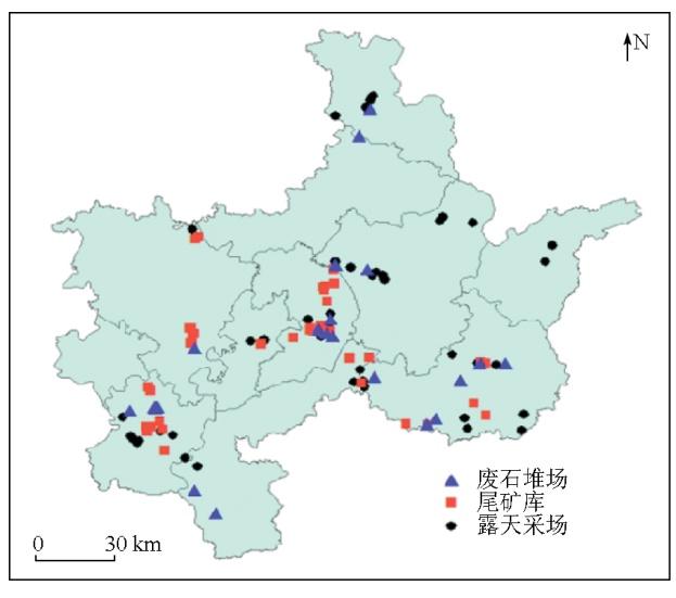
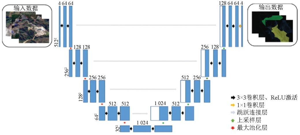
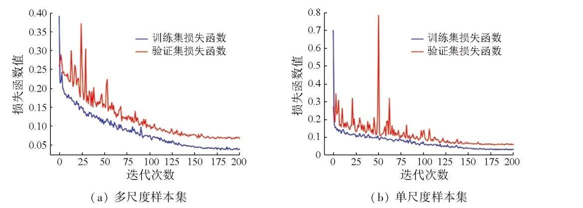
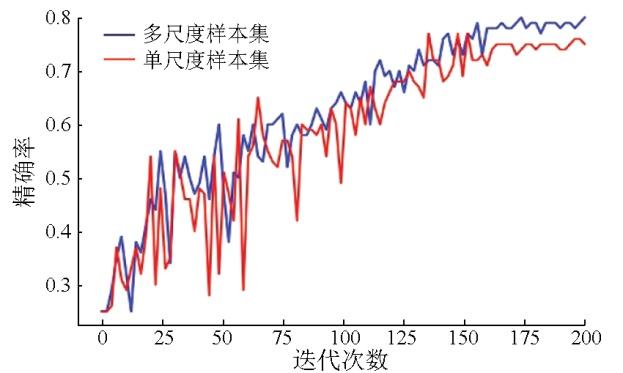
A timely and accurate understanding of the spatial extents and distributions of industrial solid waste and open pits in mining areas is significant for the precise control of solid waste contamination and the ecosystem conservation. Remote sensing technology is an effective monitoring method. However, single-scale sample sets fail to fully represent the features of industrial solid waste yards and open pits with different shapes and sizes. Constructing multiscale sample sets may be effective in solving the problem of incomplete feature representation for different industrial solid waste yards and open pits, thereby enhancing the identification accuracy and generalization capability of models. By fully considering the differences in the shape and size of different industrial solid waste yards and open pits, this study proposed a remote sensing identification method for industrial solid waste and open pits based on the multiscale sample set optimization strategy. In the proposed method, a multiscale sample set was prepared based on the preprocessed data of the GF-1B, GF-1C, and GF6 satellite remote sensing images. Subsequently, a U-Net deep learning network model was constructed to identify industrial solid waste and open pits. Finally, the identification accuracy was compared with that of the single-scale sample set model. The results show that the U-Net deep learning network model based on the multiscale sample set achieved identification accuracy of 81.23 %, recall of 66.88 %, F1-score of 73.36 %, and average intersection over union of 73.55 %, suggesting improvements by 6.02, 1.02, 3.12, and 9.86 percentage points, respectively, compared to the single-scale sample set model. Overall, this study provides a reliable approach for precisely monitoring industrial solid waste and open pits.
ZOU Haijing , ZOU Bin , WANG Yulong , ZHANG Bo , ZOU Lunwen . Remote sensing identification of industrial solid waste and open pits in mining areas based on the multiscale sample set optimization strategy[J]. Remote Sensing for Natural Resources, 2025 , 37(3) : 1 -8 . DOI: 10.6046/zrzyyg.2023385
表1 遥感影像数据说明Tab.1 Description of remote sensing image data |
| 遥感平台 | 图幅 数量/景 | 获取时间 | 空间分 辨率/m | 波段范围/nm |
|---|---|---|---|---|
| GF-1B | 3 | 2022-04-27 | 2(全色波段) 8(多光谱波段) | 450~890 |
| GF-1C | 3 | 2022-10-14 | ||
| GF-6 | 4 | 2022-12-24 |
表2 工业固废与露天采场遥感解译标志Tab.2 Remote sensing interpretation symbols for industrial solid waste and open-pit mining areas |
| 目标类型 | 影像图例 | 特征概括 |
|---|---|---|
| 废石堆场 | 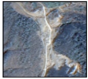 | 一般位于矿山或选矿厂附近,大多随意堆放,呈现不规则的矩形或圆形;影像上常呈现棕黑色、深灰色等,与周围地物存在明显色差 |
| 尾矿库 | 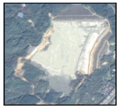 | 呈现出规则或不规则的三角形、半圆形、矩形等形状;影像上表现为明显的封闭区域,可见明显的阶梯状筑坝,常位于谷沟内;纹理特征明显细致,色调较亮 |
| 露天采场 | 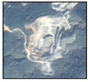 | 周边常有显著的矿山裸露地带,矿体颜色明亮;存在坑洞或裂缝等纹理特征,影像上可识别出道路或行车痕迹 |
表3 模型参数设置Tab.3 Model parameter |
| 训练参数 | 参数值 |
|---|---|
| 初始学习率 | 0.001 |
| 优化器 | Adam |
| 损失函数 | Binary cross entropy |
| 批尺寸 | 3 |
| 迭代次数 | 200 |
表4 不同尺度样本集模型识别精度对比Tab.4 Comparison of recognition accuracy on different scale sample set models(%) |
| 模型 | 样本集 | 精确率 | 召回率 | F1分数 | mIoU |
|---|---|---|---|---|---|
| U-Net | 单尺度 | 75.21 | 65.86 | 70.24 | 63.69 |
| 多尺度 | 81.23 | 66.88 | 73.36 | 73.55 | |
| DeepLabv3+ | 单尺度 | 73.06 | 58.68 | 65.09 | 61.70 |
| 多尺度 | 79.52 | 58.29 | 67.27 | 69.91 | |
| Segmenter | 单尺度 | 66.72 | 68.59 | 67.64 | 60.39 |
| 多尺度 | 71.81 | 69.28 | 70.52 | 65.81 |
表5 不同尺度样本集模型识别结果对比Tab.5 The comparison of recognition results of different scale sample set models |
| 类型 | 单尺度样本集 | 多尺度样本集 | ||||
|---|---|---|---|---|---|---|
| 遥感影像 | 样本标注 | 识别结果 | 遥感影像 | 样本标注 | 识别结果 | |
| 废石堆场 | 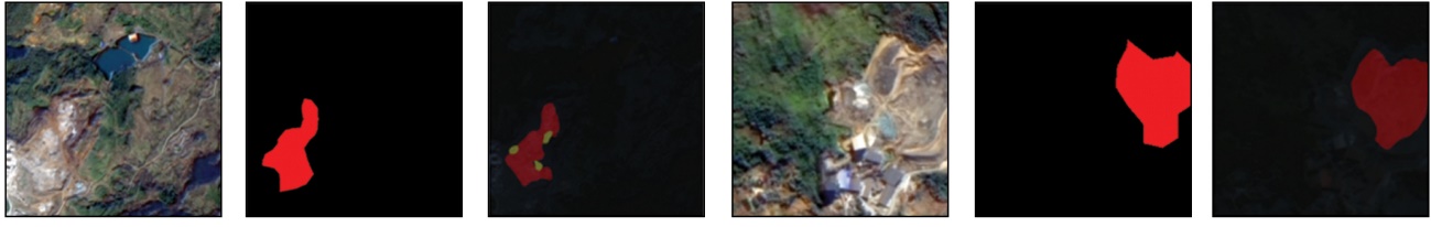 | |||||
| 尾矿库 | 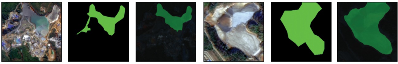 | |||||
| 露天采场 | 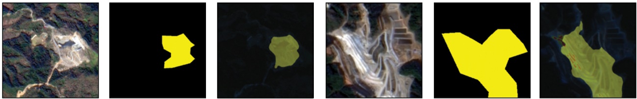 | |||||
| [1] |
孙坚, 耿春雷, 张作泰, 等. 工业固体废弃物资源综合利用技术现状[J]. 材料导报, 2012, 26(11):105-109.
|
| [2] |
|
| [3] |
|
| [4] |
刘雪龙. 面向对象的遥感影像工业固体废物信息提取方法研究[D]. 北京: 中国地质大学(北京), 2013.
|
| [5] |
|
| [6] |
|
| [7] |
|
| [8] |
|
| [9] |
|
| [10] |
|
| [11] |
吴倩雯, 况润元, 张刚华, 等. 东江源稀土矿区土地利用变化遥感监测研究[J]. 测绘科学, 2019, 44(3):51-56.
|
| [12] |
卢遥, 卢小平, 武永斌, 等. 综合机载LiDAR与高分影像的煤矿区典型地物提取方法[J]. 测绘通报, 2015(12):57-59.
|
| [13] |
|
| [14] |
李庆, 陈俊杰, 李庆亭, 等. 基于SSD模型的京津冀地区尾矿库检测[J]. 遥感技术与应用, 2021, 36(2):293-303.
|
| [15] |
闫凯, 沈汀, 陈正超, 等. 基于深度学习的SSD模型尾矿库自动提取[J]. 中国科学院大学学报, 2020, 37(3):360-367.
|
| [16] |
刘冰洁, 邢旭东, 吴浩, 等. 深度学习支持下的尾矿库遥感识别方法[J]. 测绘科学, 2021, 46(12):129-139.
|
| [17] |
张峰极. 多源遥感影像露天开采区深度学习提取方法研究[D]. 合肥: 安徽大学, 2019.
|
| [18] |
张蜀军. 基于实例分割的高分遥感无序固废堆场识别[D]. 成都: 西南交通大学, 2021.
|
| [19] |
|
| [20] |
张成业, 邢江河, 李军, 等. 基于U-Net网络和GF-6影像的尾矿库空间范围识别[J]. 自然资源遥感, 2021, 33(4):252-257.doi:10.6046/zrzyyg.2021017.
|
| [21] |
王浩. 融入图卷积全局推理的固废堆场高分遥感检测及其环境影响力评估[D]. 成都: 西南交通大学, 2021.
|
| [22] |
段彦玮, 文倩, 孙水娟, 等. 矿产资源型城市的生态承载力与可持续发展研究——以湖南省郴州市为例[J]. 湖南农机, 2011, 38(3):110-112.
|
| [23] |
李威, 邓武军, 邓家琪, 等. 郴州创建国家可持续发展议程创新示范区的实施路径与思考[J]. 中国工程咨询, 2023(8):46-50.
|
| [24] |
胡杰, 张莹, 谢仕义. 国产遥感影像分类技术应用研究进展综述[J]. 计算机工程与应用, 2021, 57(3):1-13.
|
| [25] |
何直蒙, 丁海勇, 安炳琪. 高分辨率遥感影像建筑物提取的空洞卷积E-Unet算法[J]. 测绘学报, 2022, 51(3):457-467.
|
| [26] |
|
| [27] |
|
| [28] |
|
| [29] |
许玥, 冯梦如, 皮家甜, 等. 基于深度学习模型的遥感图像分割方法[J]. 计算机应用, 2019, 39(10):2905-2914.
|
/
| 〈 |
|
〉 |