
Remote Sensing for Natural Resources >
Hazard assessment of potential glacial lake outburst floods in the Yadong River basin based on multisource satellite data
Received date: 2023-11-24
Revised date: 2024-01-29
Online published: 2026-06-03
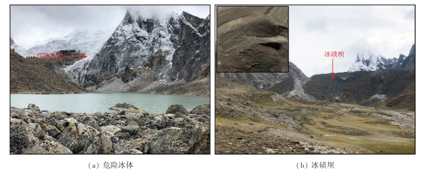
In recent years, global warming has caused significant glacier retreats in the Qinghai-Tibet Plateau, leading to the rapid expansion of glacial lakes and an increased threat of glacial lake outburst floods (GLOFs). The Yadong River basin, located in Shigatse, Tibet, hosts a large number of glacial lakes. In 1940, a GLOF from Qiongbixiama Co severely damaged Yadong County 40 km downstream, causing house collapse and infrastructure destruction. Therefore, assessing the hazards of potential GLOSs in the Yadong River basin is vital for protecting the safety of people’s lives and property. This study conducted a survey and assessment of potential GLOFs based on Gaofen satellite data and Landsat remote sensing images. It derived basic elements including glaciers, glacial lakes, and moraines through remote sensing image interpretation. The results show that the Yadong River basin develops 28 glaciers and 228 glacial lakes, covering total areas of 34.03 km2 and 7.79 km2, respectively. The past 30 years have seen slight retreats of glaciers and slight expansions of glacial lakes. Combined with the elements derived from remote sensing images, the analytic hierarchy process and fuzzy comprehensive assessment were employed to preliminarily assess the hazard of regional glacial lakes, delineating the distribution of potentially hazardous glacial lakes. The assessment results reveal 15 potentially hazardous glacial lakes in the Yadong River basin, including five highly hazardous, eight moderately hazardous, and two slightly hazardous glacial lakes. These lakes are primarily distributed in the northeastern and northwestern high mountain areas in the Yadong River basin.
ZHU Dengxin , TU Jienan , SUN Haibing , HAN Zhenjie , TONG Liqiang , GUO Zhaocheng , YU Jiangkuan , YAN Shuhao , HE Peng , ZHU Junjie . Hazard assessment of potential glacial lake outburst floods in the Yadong River basin based on multisource satellite data[J]. Remote Sensing for Natural Resources, 2025 , 37(2) : 96 -107 . DOI: 10.6046/zrzyyg.2023356
表1 使用遥感数据具体信息Tab.1 Specific information of remote sensing data |
| 序号 | 卫星 | 传感器 | 分辨率/m | 时间 | 行列号或经纬度 |
|---|---|---|---|---|---|
| 1 | Landsat5 | TM传感器 | 30 | 19910921 | 139041 |
| 2 | Landsat5 | TM传感器 | 30 | 19911007 | 139041 |
| 3 | Landsat5 | TM传感器 | 30 | 19911108 | 139041 |
| 4 | Landsat5 | TM传感器 | 30 | 19920324 | 139041 |
| 5 | Landsat5 | TM传感器 | 30 | 19920416 | 139041 |
| 6 | Landsat8 | OLI传感器 | 15 | 20201123 | 139041 |
| 7 | Landsat8 | OLI传感器 | 15 | 20201225 | 139041 |
| 8 | Landsat8 | OLI传感器 | 15 | 20210211 | 139041 |
| 9 | 高分一号B星 | PMS传感器 | 2 | 20210827 | E89.0_N27.4 |
| 10 | 高分一号D星 | PMS传感器 | 2 | 20210101 | E89.1_N28.0 |
表2 冰湖溃决灾害评价要素详细信息及来源Tab.2 Detailed information and source of evaluation elements of glacier lake break disaster |
| 地貌和地质条件 | 定性/定量 | 有关属性 | 数据来源 |
|---|---|---|---|
| 冰湖类型 | 定性 | 冰湖成因类型 | 高分影像 |
| 冰湖后缘陡坎高度 | 定量 | 高差 | DEM数据 |
| 冰湖与冰川距离 | 定量 | 距离 | 高分影像 |
| 补给冰川的冰舌坡度 | 定量 | 坡度 | DEM数据 |
| 危险冰体的面积与冰湖面积的比例 | 定量 | 危险面积、面积比 | 高分影像 |
| 冰湖面积 | 定量 | 面积 | 高分影像 |
| 冰碛坝体坝顶较窄 | 定量 | 坝顶宽度 | 高分影像 |
| 冰碛垄坡度较陡 | 定量 | 平均坡度、最大坡度 | DEM数据 |
| 冰湖扩张速率 | 定量 | 扩张速率 | 高分影像 |
| 补给冰川为悬冰川 | 定性 | 冰川形态类型 | 高分影像 |
| 冰湖与终碛垄和补给冰川的相对位置 | 定性 | 相对位置 | 高分影像 |
表3 冰湖溃决要素的判断矩阵Tab.3 Judgment matrix of glacier lake outburst element |
| 要素 | X1 | X2 | X3 | X4 | X5 | X6 | X7 | X8 | X9 | X10 | X11 |
|---|---|---|---|---|---|---|---|---|---|---|---|
| X1 | 1 | 1 | 1 | 2 | 2 | 2 | 3 | 5 | 5 | 7 | 7 |
| X2 | 1 | 1 | 1 | 2 | 2 | 2 | 3 | 5 | 5 | 7 | 7 |
| X3 | 1 | 1 | 1 | 2 | 2 | 2 | 3 | 5 | 5 | 7 | 7 |
| X4 | 1/2 | 1/2 | 1/2 | 1 | 1 | 1 | 2 | 3 | 4 | 6 | 6 |
| X5 | 1/2 | 1/2 | 1/2 | 1 | 1 | 1 | 2 | 3 | 4 | 6 | 6 |
| X6 | 1/2 | 1/2 | 1/2 | 1 | 1 | 1 | 2 | 3 | 4 | 6 | 6 |
| X7 | 1/3 | 1/3 | 1/3 | 1/2 | 1/2 | 1/2 | 1 | 3 | 3 | 5 | 5 |
| X8 | 1/5 | 1/5 | 1/5 | 1/3 | 1/3 | 1/3 | 1/3 | 1 | 2 | 4 | 4 |
| X9 | 1/5 | 1/5 | 1/5 | 1/4 | 1/4 | 1/4 | 1/3 | 1/2 | 1 | 3 | 3 |
| X10 | 1/7 | 1/7 | 1/7 | 1/6 | 1/6 | 1/6 | 1/5 | 1/4 | 1/3 | 1 | 1 |
| X11 | 1/7 | 1/7 | 1/7 | 1/6 | 1/6 | 1/6 | 1/5 | 1/4 | 1/3 | 1 | 1 |
表4 各区间值对应的隶属函数Tab.4 The membership function corresponding to the values between regions |
| 区间 | I | II | III |
|---|---|---|---|
| a≤x≤(a+b)/2 | 0 | ||
| (a+b)/2<x≤b | 0 | ||
| b<x≤(b+c)/2 | 0 | ||
| (b+c)/2<x≤c | 0 | ||
| x>c | 0 |
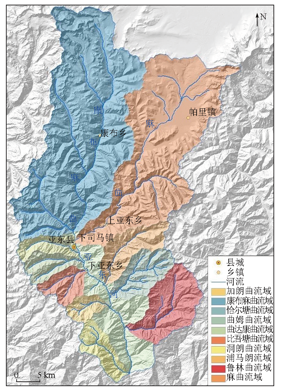
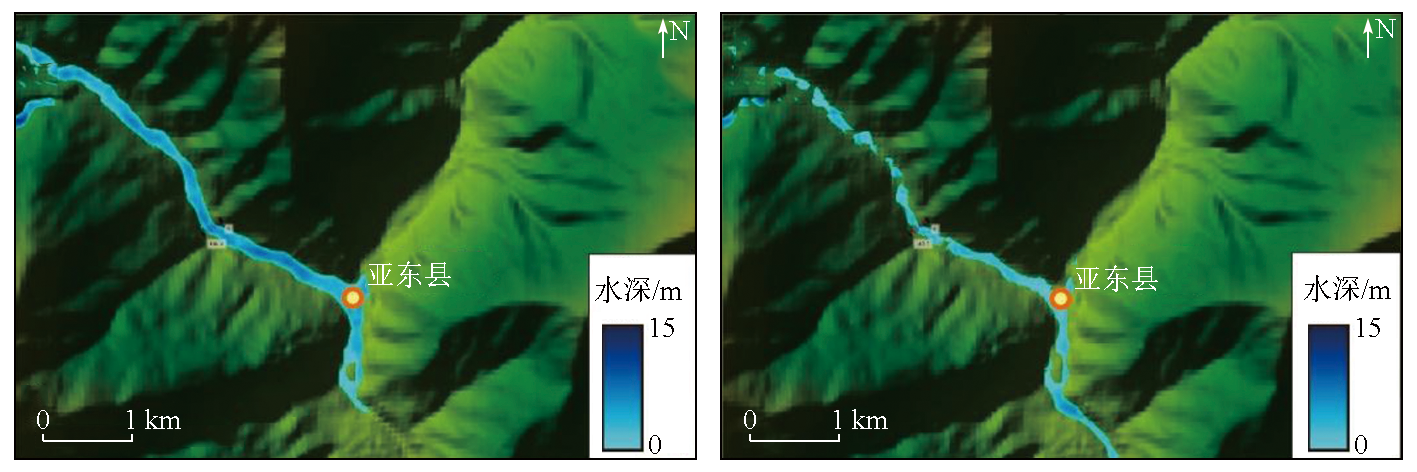
图3 亚东河流域冰川冰湖分布Fig.3 Distribution of glacier and glacier lake in Yadong River basin |
表5 不同流域冰川分布情况Tab.5 Distribution of glaciers in different basins |
| 流域 | 年份 | |||||
|---|---|---|---|---|---|---|
| 1991年 | 2021年 | 变化 | ||||
| 数量/条 | 面积/ km2 | 数量/条 | 面积/ km2 | 数量变 化/条 | 面积变 化/km2 | |
| 康布麻曲流域 | 25 | 32.446 | 20 | 30.516 | -5 | -1.93 |
| 麻曲流域 | 8 | 4.062 | 8 | 3.510 | 0 | -0.55 |
| 合计 | 33 | 36.508 | 28 | 34.026 | -5 | -2.48 |
表6 按流域统计冰湖数据Tab.6 Statistics of glacier lakes by basin |
| 冰湖 | 1991年 | 2021年 | 变化 | |||
|---|---|---|---|---|---|---|
| 数量/个 | 面积/km2 | 数量/个 | 面积/km2 | 数量变化/个 | 面积/km2 | |
| 康布麻曲流域 | 98 | 3.779 | 108 | 3.701 | 10 | -0.078 |
| 麻曲流域 | 30 | 1.101 | 27 | 1.062 | -3 | -0.039 |
| 曲姆曲流域 | 11 | 0.718 | 13 | 0.836 | 2 | 0.118 |
| 浦马朗流域 | 10 | 0.705 | 13 | 0.724 | 3 | 0.019 |
| 洞朗曲流域 | 13 | 0.378 | 15 | 0.401 | 2 | 0.023 |
| 鲁林曲流域 | 5 | 0.255 | 11 | 0.433 | 6 | 0.178 |
| 加朗曲流域 | 6 | 0.158 | 10 | 0.180 | 4 | 0.022 |
| 恰尔塘曲流域 | 8 | 0.159 | 10 | 0.118 | 2 | -0.041 |
| 曲达康曲流域 | 11 | 0.137 | 11 | 0.171 | 0 | 0.034 |
| 比吾塘曲流域 | 9 | 0.117 | 10 | 0.165 | 1 | 0.048 |
| 合计 | 201 | 7.507 | 228 | 7.791 | 27 | 0.284 |
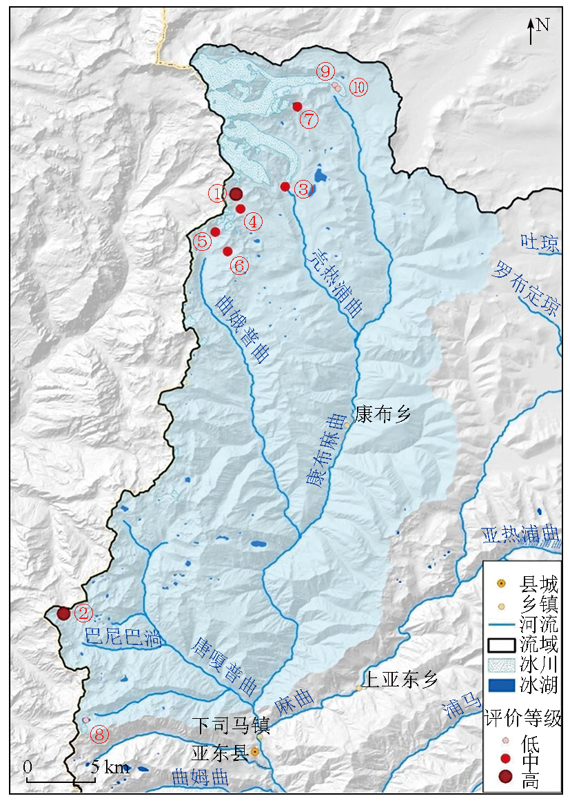
表7 康布麻曲流域中冰湖信息Tab.7 Information table of glacier lake in Kangbumaqu basin |
| 序号 | 冰湖编码 | 面积/m2 | 经度/(°) | 纬度/(°) | 危险 等级 |
|---|---|---|---|---|---|
| 1 | GL088889E27842N | 10 668.90 | 88.889 6 | 27.842 5 | 高 |
| 2 | GL088776E27566N | 4 058.83 | 88.776 2 | 27.566 7 | 高 |
| 3 | GL088921E27847N | 42 114.90 | 88.921 9 | 27.847 4 | 中 |
| 4 | GL088892E27832N | 23 437.70 | 88.892 6 | 27.832 8 | 中 |
| 5 | GL088875E27817N | 36 026.00 | 88.875 9 | 27.817 6 | 中 |
| 6 | GL088884E27804N | 15 963.40 | 88.884 1 | 27.804 7 | 中 |
| 7 | GL088930E27899N | 155 118.00 | 88.930 0 | 27.899 9 | 中 |
| 8 | GL088790E27496N | 159 937.00 | 88.790 8 | 27.496 7 | 低 |
| 9 | GL088954E27914N | 17 982.50 | 88.954 5 | 27.914 2 | 低 |
| 10 | GL088956E27911N | 13 013.70 | 88.956 8 | 27.911 6 | 低 |
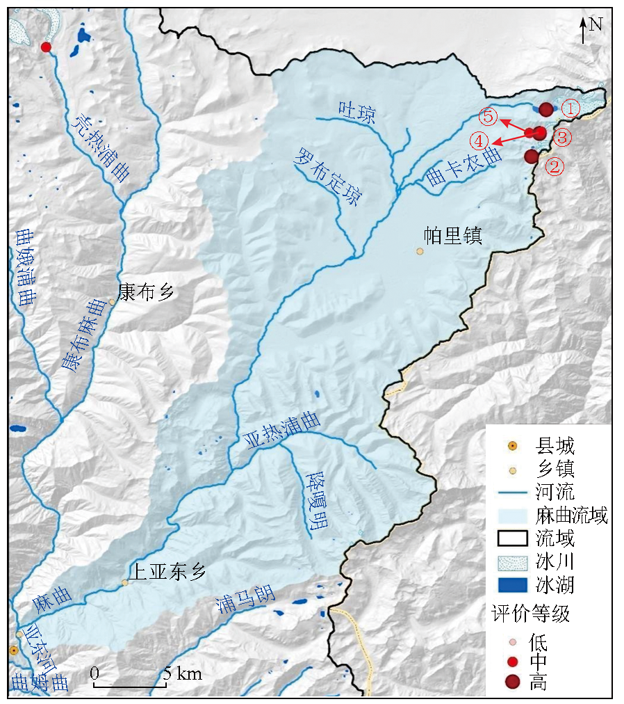
表8 麻曲流域冰湖信息Tab.8 Information table of glacier lake in Maqu basin |
| 序号 | 冰湖编码 | 面积/m2 | 经度/(°) | 纬度/(°) | 危险 等级 |
|---|---|---|---|---|---|
| 1 | GL089230E27808N | 562 194.00 | 89.230 5 | 27.808 8 | 高 |
| 2 | GL089221E27780N | 9 330.24 | 89.221 6 | 27.780 0 | 高 |
| 3 | GL089227E27795N | 10 876.20 | 89.227 4 | 27.795 4 | 高 |
| 4 | GL089226E27794N | 12 770.20 | 89.226 3 | 27.794 3 | 中 |
| 5 | GL089220E27794N | 35 529.60 | 89.220 1 | 27.794 5 | 中 |
| [1] |
|
| [2] |
余斌, 何元勋, 刘秧. 冰碛湖溃决易发性的定量评价[J]. 地球科学, 2022, 47(6):1999-2014.
|
| [3] |
张太刚, 王伟财, 高坛光, 等. 亚洲高山区冰湖溃决洪水事件回顾[J]. 冰川冻土, 2021, 43(6): 1673-1692.
|
| [4] |
杨兴国, 曹志翔, 邢会歌, 等. 冰碛土滑坡—泥石流—堰塞湖灾害链发展过程机理与模拟技术研究构想[J]. 工程科学与技术, 2022, 54(3): 1-13.
|
| [5] |
王欣, 刘时银, 姚晓军, 等. 我国喜马拉雅山区冰湖遥感调查与编目[J]. 地理学报, 2010, 65(1):29-36.
|
| [6] |
程尊兰, 朱平一, 宫怡文. 典型冰湖溃决型泥石流形成机制分析[J]. 山地学报, 2003, 21(6):716-720.
|
| [7] |
|
| [8] |
|
| [9] |
王欣, 刘时银, 郭万钦, 等. 我国喜马拉雅山区冰碛湖溃决危险性评价[J]. 地理学报, 2009, 64(7): 782-790.
|
| [10] |
车涛, 晋锐, 李新, 等. 近 20 a来西藏朋曲流域冰湖变化及潜在溃决冰湖分析[J]. 冰川冻土, 2004, 26(4):397-402.
|
| [11] |
王跃, 安天浩. 典型冰湖溃决泥石流成因分析及危险性评价体系探讨[J]. 矿产勘查, 2018, 9(4):727-731.
|
| [12] |
刘建康, 张佳佳, 高波, 等. 我国西藏地区冰湖溃决灾害综述[J]. 冰川冻土, 2019, 41(6): 1335-1347.
|
| [13] |
周路旭, 刘建康, 李元灵. 川藏交通廊道龙利空泽错冰碛湖溃决危险性评价[J]. 地理与地理信息科学, 2020, 36(6):32-39,47.
|
| [14] |
乐茂华, 唐川, 张丹丹, 等. 基于逻辑回归法的西藏地区冰湖溃决危险性预测模型[J]. 自然灾害学报, 2014, 23(5): 177-184.
|
| [15] |
|
| [16] |
亚东县人民政府. 亚东县概况[EB/OL]. [2021-06-23] http://www.ydx.gov.cn/news-detail.thtml?cid=136260
Yadong County People's Government. Overview of Yadong County[EB/OL]. [2021-06-23] http://www.ydx.gov.cn/news-detail.thtml?cid=136260
|
| [17] |
童立强, 祁生文, 安国英, 等. 喜马拉雅山地区重大地质灾害遥感调查研究[M]. 北京: 科学出版社, 2013:116.
|
| [18] |
刘时银, 姚晓军, 郭万钦, 等. 基于第二次冰川编目的中国冰川现状[J]. 地理学报, 2015, 70(1):3-16.
|
| [19] |
姚晓军, 刘时银, 韩磊, 等. 冰湖的界定与分类体系——面向冰湖编目和冰湖灾害研究[J]. 地理学报, 2017, 72(7):1173-1183.
|
| [20] |
王世金, 汪宙峰. 冰湖溃决灾害综合风险评估与管控:以中国喜马拉雅山区为例[M]. 北京: 中国社会科学出版社, 2017: 91-95.
|
| [21] |
陈晓清, 崔鹏, 杨忠, 等. 近15 a喜玛拉雅山中段波曲流域冰川和冰湖变化[J]. 冰川冻土, 2005, 27(6):793-800.
|
| [22] |
范建容, 李炫, 游勇, 等. 川藏铁路然乌—通麦段冰湖溃决危险性模糊综合评价及应用[C]// “川藏铁路建设的挑战与对策”2016 学术交流会论文集.中国科学院水利部成都山地灾害与环境研究所, 2016.
|
| [23] |
崔志超, 王俊豪, 崔传峰, 等. 基于层次分析法和模糊数学相结合的甘肃东乡八丹沟泥石流易发性评价[J]. 中国地质灾害与防治学报, 2020, 31(1):44-50.
|
/
| 〈 |
|
〉 |

