
Remote Sensing for Natural Resources >
Downscaling of precipitation products based on the random forest and assessment of their hydrologic applicability
Received date: 2023-11-14
Revised date: 2024-01-04
Online published: 2026-06-03
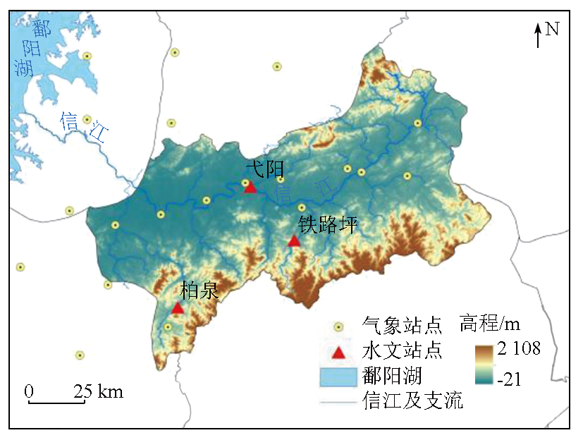
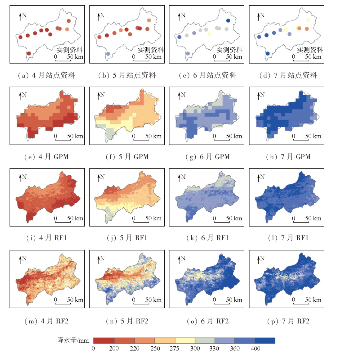
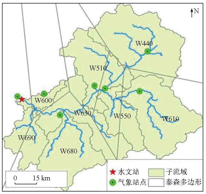
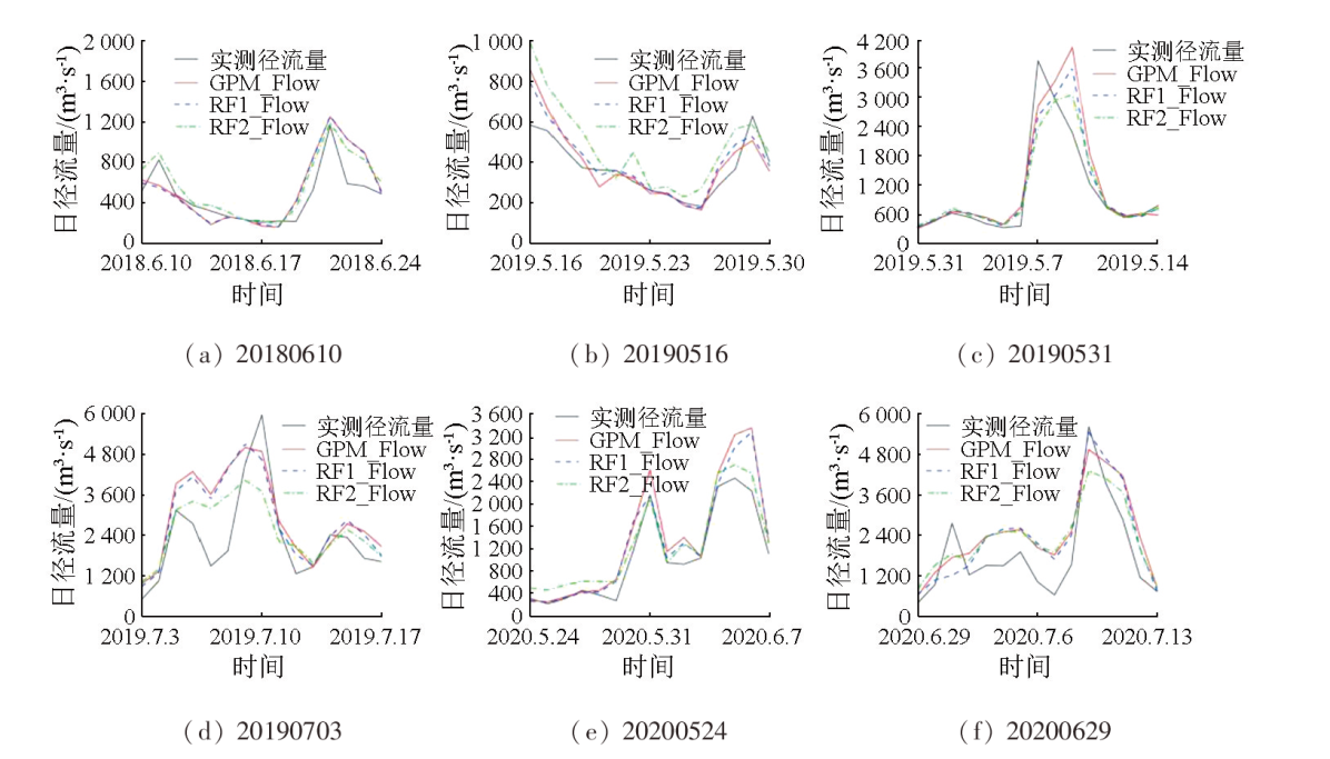
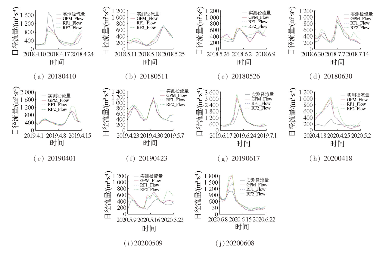
Precipitation products, including the Global Precipitation Measurement (GPM) mission, have been widely used in river basin studies due to their advantages like continuous distributions and broad spatial ranges. However, they are limited by insufficient accuracy and low spatial resolution. Based on the random forest (RF), this study integrated multisource influencing factors to generate two daily precipitation products with high spatial resolution: RF1 and RF2. The two daily precipitation products were input to the Hydrologic Engineering Center’s Hydrologic Modeling System (HEC-HMS) model to simulate daily runoff changes in the Xinjiang River basin. Finally, this study assessed the contributions of RF1 and RF2 to the improvement of GPM’s hydrologic applicability. The results show that both RF1 and RF2 improved the accuracy and distribution details of GPM data. RF2 exhibited a higher correlation and lower error, whereas RF1 manifested superior performance in detecting precipitation events. The RF1-simulated runoff curves resembled GPM-derived curves, showing significant improvements. RF2 corrected partial GPM’s overestimates and more accurately revealed the peak values of real flow curves in some periods. However, the uneven distribution of monitoring stations affected RF2’s prediction in complex terrain areas, limiting its simulation accuracy. Overall, both RF1 and RF2 can effectively reflect daily precipitation changes in the Xinjiang River basin, improving GPM’s hydrologic applicability to varying degrees.
Key words: downscaling; GPM; random forest; runoff simulation; Xinjiang River basin
CHEN Duoyan , SHI Lan . Downscaling of precipitation products based on the random forest and assessment of their hydrologic applicability[J]. Remote Sensing for Natural Resources, 2025 , 37(2) : 66 -79 . DOI: 10.6046/zrzyyg.2023352
表1 HEC-HMS模型计算方法选择Tab.1 HEC-HMS calculation method selection |
| 计算模块 | 计算方法 | 方法原理与输入参数 |
|---|---|---|
| 产流计算 | SCS曲线数法 | 根据累积降雨量、土地利用方式、土壤类型以及前期土壤含水量等条件模拟计算产流量,由土壤最大蓄水能力与流域特征的关系引入参数CN |
| 直接径流计算 | 斯奈德单位线法 | 通过收集某集水区的降雨和径流资料,算出单位线,单位线峰现时间与流量滞时tlag有关 |
| 基流计算 | 指数衰退法 | 假设集水区任意时刻的基流量和初始基流存在某种关系,由流量成分取值衰减常数k |
| 河道汇流计算 | 马斯京根法 | 将马斯京根槽蓄曲线方程和水量平衡方程联合演算出马斯京根流量演算方程,需要输入蓄量常数K和流量比重因子x |
表2 各地形因子的相关系数Tab.2 Correlation coefficients between topographic factors |
| 地形因子 | 海拔 | 坡度 | 地形起伏度 | 地形切割度 | 地形位置指数 | 地形曲率 |
|---|---|---|---|---|---|---|
| 海拔 | 1.000**① | 0.718** | 0.819** | 0.858** | 0.314** | 0.544** |
| 坡度 | 1.000** | 0.920** | 0.886** | 0.011** | 0.614** | |
| 地形起伏度 | 1.000** | 0.958** | 0.044** | 0.670** | ||
| 地形切割度 | 1.000** | 0.088** | 0.614** | |||
| 地形位置指数 | 1.000** | -0.079** | ||||
| 地形曲率 | 1.000** |
①**表示通过0.01水平的显著性水平检验。 |
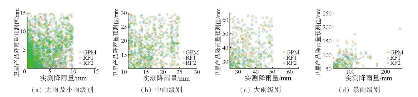
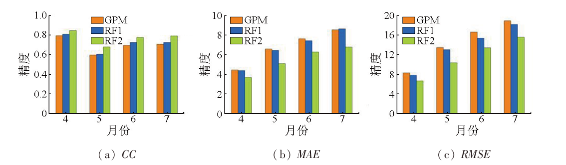
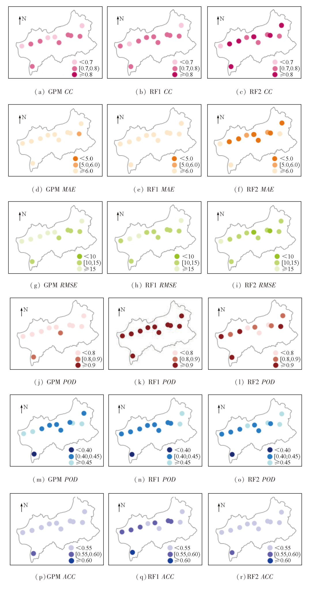
表3 不同产品日降水精度与降水事件探测能力评价Tab.3 Evaluation of daily precipitation accuracy and precipitation event detection ability of products |
| 产品 | 精度评价指标 | 日降水 事件 | 探测 能力 | 评价 指标 | ||
|---|---|---|---|---|---|---|
| CC | MAE/mm | RMSE/mm | POD | FAR | ACC | |
| GPM | 0.696 | 6.833 | 14.894 | 0.772 | 0.448 | 0.523 |
| RF1 | 0.717 | 6.766 | 14.141 | 0.970 | 0.438 | 0.564 |
| RF2 | 0.779 | 5.480 | 11.991 | 0.871 | 0.451 | 0.530 |
表4 弋阳站GPM,RF1,RF2径流模拟精度评估Tab.4 Evaluation of hydrological simulation accuracy of GPM,RF1 and RF2 in Yiyang Station |
| 场次 | 参数 | GPM | RF1 | RF2 | 场次 | 参数 | GPM | RF1 | RF2 | |
|---|---|---|---|---|---|---|---|---|---|---|
| 率 定 期 | 20180410 | RNS | 0.697 | 0.689 | 0.499 | 20190423 | RNS | 0.806 | 0.851 | 0.546 |
| RCC | 0.892 | 0.870 | 0.754 | RCC | 0.915 | 0.938 | 0.854 | |||
| 20180511 | RNS | 0.870 | 0.909 | 0.751 | 20190516 | RNS | 0.509 | 0.643 | -0.459 | |
| RCC | 0.943 | 0.959 | 0.937 | RCC | 0.877 | 0.904 | 0.855 | |||
| 20180526 | RNS | 0.427 | 0.495 | 0.304 | 20190531 | RNS | 0.703 | 0.791 | 0.822 | |
| RCC | 0.764 | 0.779 | 0.874 | RCC | 0.887 | 0.898 | 0.907 | |||
| 20180610 | RNS | 0.414 | 0.433 | 0.631 | 20190617 | RNS | 0.218 | 0.363 | -0.196 | |
| RCC | 0.836 | 0.836 | 0.936 | RCC | 0.800 | 0.854 | 0.724 | |||
| 20180630 | RNS | 0.644 | 0.667 | 0.367 | 20190703 | RNS | 0.377 | 0.435 | 0.523 | |
| RCC | 0.965 | 0.970 | 0.883 | RCC | 0.788 | 0.790 | 0.746 | |||
| 20190401 | RNS | 0.712 | 0.788 | -0.117 | ||||||
| RCC | 0.910 | 0.923 | 0.848 | |||||||
| 验 证 期 | 20200418 | RNS | -0.169 | 0.062 | -0.658 | 20200608 | RNS | 0.289 | 0.773 | 0.110 |
| RCC | 0.727 | 0.709 | 0.746 | RCC | 0.956 | 0.972 | 0.947 | |||
| 20200509 | RNS | -3.681 | -1.988 | -4.469 | 20200629 | RNS | 0.600 | 0.610 | 0.618 | |
| RCC | 0.163 | 0.312 | 0.166 | RCC | 0.879 | 0.872 | 0.867 | |||
| 20200524 | RNS | 0.608 | 0.712 | 0.893 | ||||||
| RCC | 0.977 | 0.963 | 0.989 | |||||||
| [1] |
|
| [2] |
|
| [3] |
刘冀, 孙周亮, 张特, 等. 基于不同卫星降雨产品的澴水花园流域径流模拟比较研究[J]. 长江流域资源与环境, 2018, 27(11):2558-2567.
|
| [4] |
王书霞, 张利平, 喻笑勇, 等. 遥感降水产品在澜沧江流域径流模拟中的适用性研究[J]. 长江流域资源与环境, 2019, 28(6):1365-1374.
|
| [5] |
蔡洁连. 基于VIC模型的卫星降水产品在赣江流域的应用研究[D]. 南宁: 南宁师范大学, 2021.
|
| [6] |
|
| [7] |
|
| [8] |
孙赫, 苏凤阁. 雅鲁藏布江流域多源降水产品评估及其在水文模拟中的应用[J]. 地理科学进展, 2020, 39(7):1126-1139.
|
| [9] |
范宏翔, 何菡丹, 徐力刚, 等. 基于长短记忆模型的鄱阳湖流域径流模拟及其演变的归因分析[J]. 湖泊科学, 2021, 33(3):866-878.
|
| [10] |
张帆, 张永勇, 陈俊旭, 等. 多种机器学习模型对不同洪水类型特征指标模拟效果评估[J]. 地理科学进展, 2022, 41(7):1239-1250.
|
| [11] |
|
| [12] |
|
| [13] |
|
| [14] |
闵心怡, 杨传国, 李莹, 等. 基于改进的湿润地区站点与卫星降雨数据融合的洪水预报精度分析[J]. 水电能源科学, 2020, 38(04):1-5.
|
| [15] |
田晶, 郭生练, 刘德地, 等. 气候与土地利用变化对汉江流域径流的影响[J]. 地理学报, 2020, 75(11):2307-2318.
|
| [16] |
孙桂凯, 魏义熊, 王亚芳, 等. IMERG卫星降水产品融合校准及其水文效用[J]. 水电能源科学, 2021, 39(11):23-26.
|
| [17] |
|
| [18] |
|
| [19] |
|
| [20] |
廖如婷, 胡珊珊, 杜龙刚, 等. 基于HEC-HMS模型的温榆河流域水文模拟[J]. 南水北调与水利科技, 2018, 16(6):15-20.
|
| [21] |
|
| [22] |
李相虎, 张奇, 邵敏. 基于TRMM数据的鄱阳湖流域降雨时空分布特征及其精度评价[J]. 地理科学进展, 2012, 31(9):1164-1170.
|
| [23] |
曾冰茹, 李云良, 谭志强. 鄱阳湖流域水文连通性的影响因素和环境效应[J]. 长江流域资源与环境, 2022, 31(12):2718-2728.
|
| [24] |
田智慧, 尹传鑫, 王晓蕾. 鄱阳湖流域生态环境动态评估及驱动因子分析[J]. 环境科学, 2023, 44(2):816-827.
|
| [25] |
徐新良. 中国月度植被指数(NDVI)空间分布数据集[EB/OL]. 中国科学院资源环境科学数据中心数据注册与出版系统(http:/www.resdc.cn/DOI), 2018.
|
| [26] |
|
| [27] |
欧立健, 余锦华, 钟校尧, 等. 海表温度的增暖趋势和自然变率对长江中下游夏季极端降水强度的影响[J]. 大气科学, 2022. 46(6):1595-1606.
|
| [28] |
陈玥, 王爱慧, 支蓉, 等. 中国东部降水中大尺度环流和局地陆-气相互作用的贡献:河南“21·7”强降水事件特征影响因子探究[J]. 大气科学, 2023, 47(2):551-566.
|
| [29] |
潘锋, 何大明, 曹杰, 等. 夏季怒江流域水汽输送多支特征及对降水影响[J]. 地理学报, 2023, 78(1):87-100.
|
| [30] |
|
| [31] |
|
| [32] |
薛智暄, 张丽, 王新军, 等. 古尔班通古特沙漠SMAP土壤水分产品降尺度分析[J]. 干旱区研究, 2023, 40(4):583-593.
|
| [33] |
郭远智, 李许红. 基于随机森林模型的黄河流域城市建设用地结构时空演化及其驱动机制研究[J]. 地理科学进展, 2023, 42(1):12-26.
|
| [34] |
李娜娜, 吴骅, 栾庆祖. 城市地表温度空间降尺度研究——以北京市为例[J]. 遥感学报, 2021, 25(8):1808-1820.
|
| [35] |
曾岁康, 雍斌. 全球降水计划IMERG和GSMaP反演降水在四川地区的精度评估[J]. 地理学报, 2019, 74(7):1305-1318.
|
| [36] |
彭振华, 李艳忠, 余文君, 等. 遥感降水产品在中国不同气候区的适用性研究[J]. 地球信息科学学报, 2021, 23(7):1296-1311.
|
| [37] |
曹旖丹. 气候变化下长白山二道松花江流域降雨径流模拟及预测[D]. 长春: 吉林大学, 2021.
|
| [38] |
原文林, 付磊, 高倩雨. 基于HEC-HMS模型的山洪灾害临界雨量研究[J]. 人民黄河, 2019, 41(8):22-27,31.
|
| [39] |
|
| [40] |
张利平, 覃光华, 杨玲玲, 等. IMERG和GSMaP卫星降水产品在岷江流域的适用性评价[J]. 水文, 2022, 42(6):93-98.
|
/
| 〈 |
|
〉 |