
Remote Sensing for Natural Resources >
Collaborative monitoring of abandoned arable land in cloudy and rainy areas based on multisource remote sensing data
Received date: 2023-11-14
Revised date: 2024-02-29
Online published: 2026-06-03
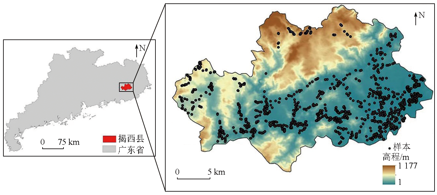
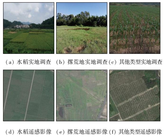
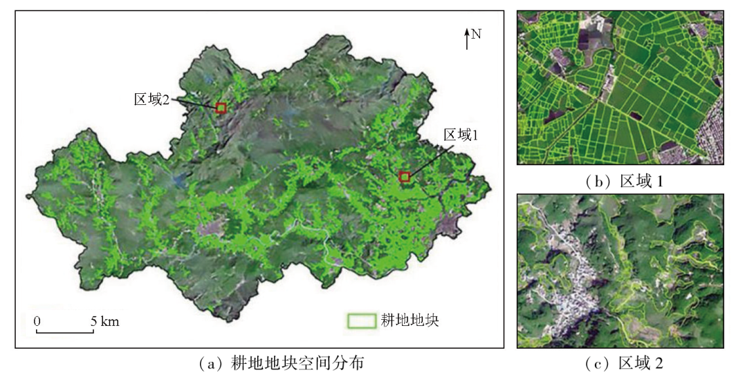
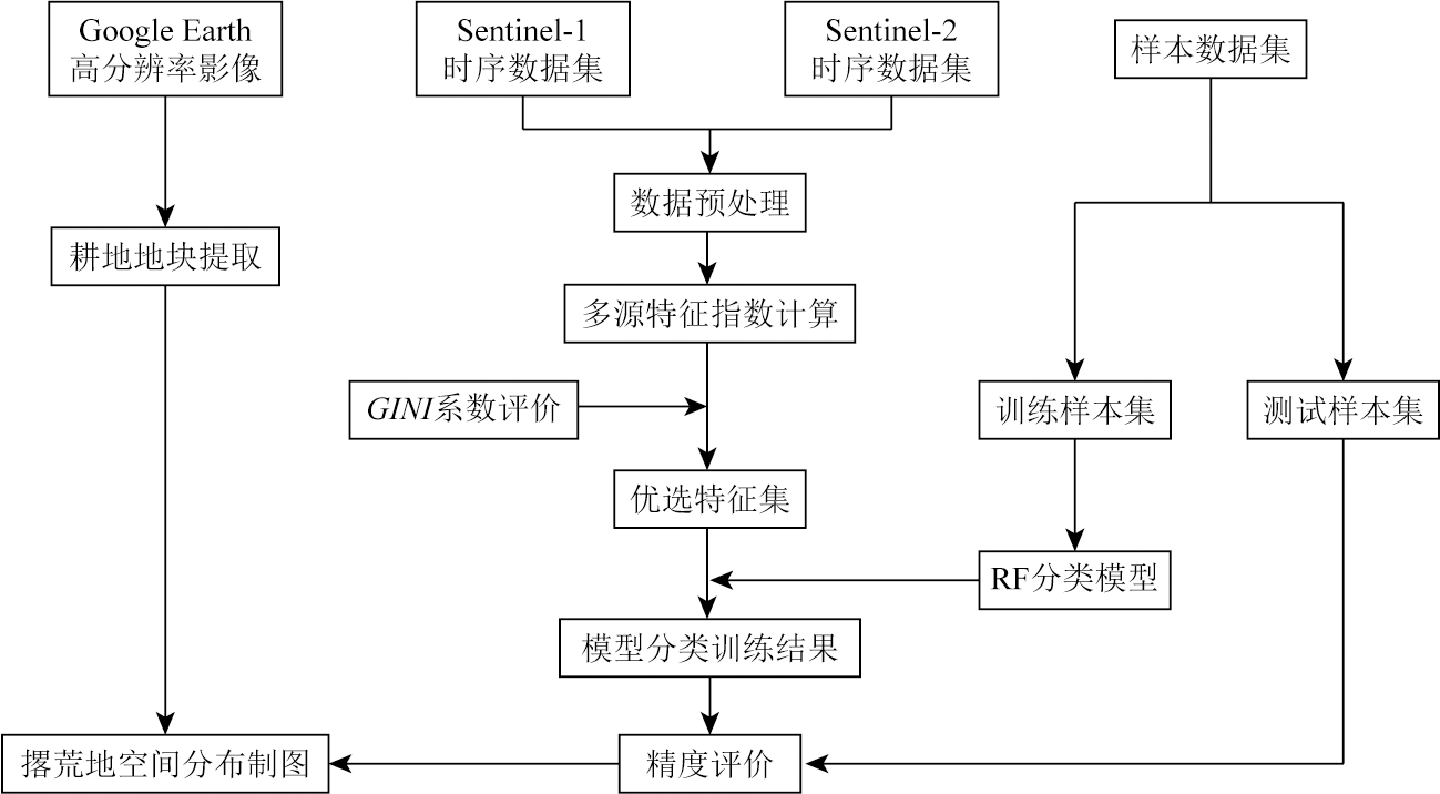
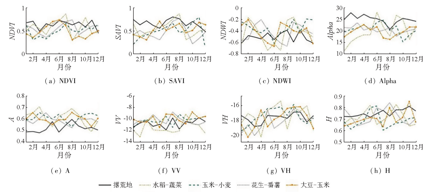
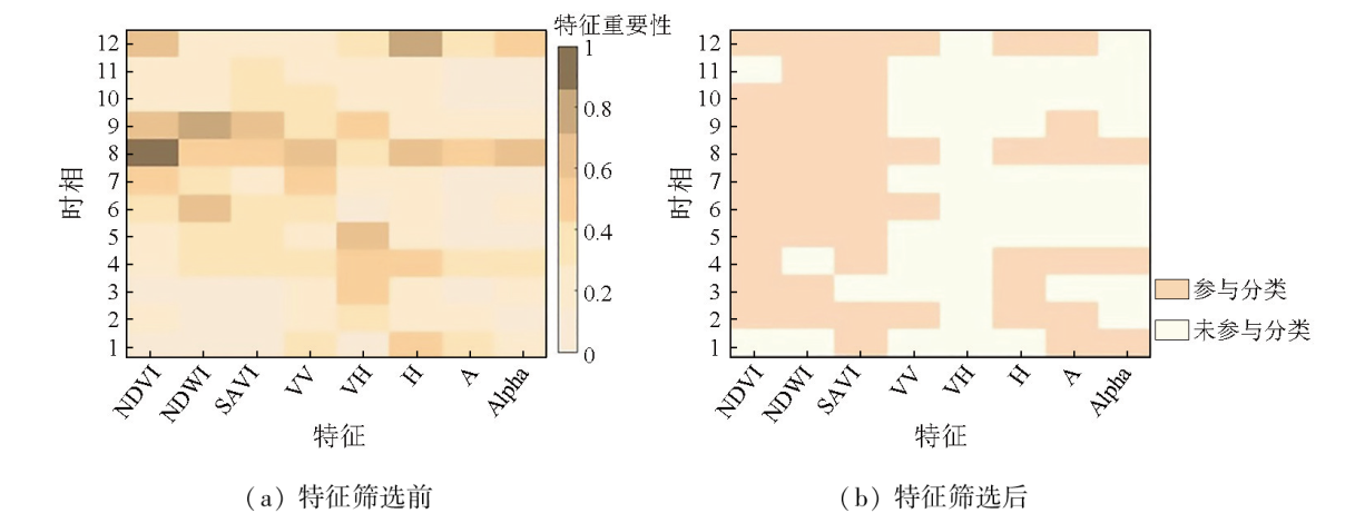
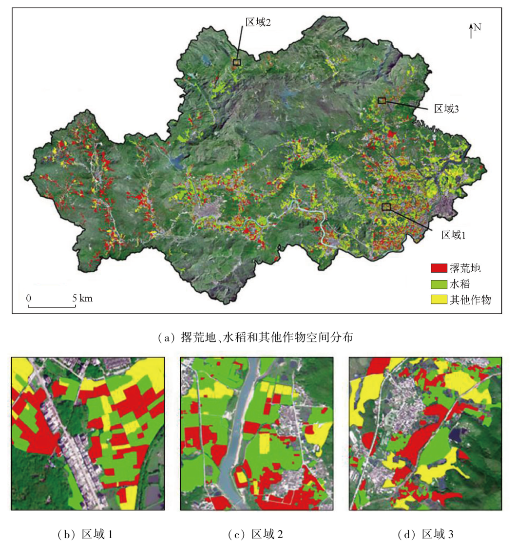
In cloudy and rainy areas, the humid and hot climate and cloud contamination during the rainy season often cause the loss of optical data. Hence, optical data alone fail to enable the accurate monitoring of abandoned land. This study proposed a method for monitoring abandoned land in cloudy and rainy areas based on multisource remote sensing data. By integrating optical and synthetic aperture Radar (SAR) remote sensing data, this study extracted the multitemporal optical and SAR-derived features of vegetation and assessed their importance using the GINI index. Employing the random forest classifier, this study mapped the spatial distribution of abandoned land in Jiexi County in 2021. The results show that the proposed method achieved a relatively high accuracy in identifying abandoned land in cloudy and rainy areas, yielding an overall accuracy of 87.0%. This value represents an improvement of 6.7 and 13.8 percentage points, respectively, compared to the results derived solely from optical and SAR remote sensing features. The analysis reveals that the normalized difference vegetation index (NDVI), soil-adjusted vegetation index (SAVI), polarization entropy, normalized difference water index (NDWI), and anti-entropy are crucial for identifying abandoned land. Additionally, key months for distinguishing abandoned from non-abandoned land include February, April, June, August, and December. This study establishes a monitoring model for abandoned land based on multisource features and multitemporal phases, providing technical support for monitoring abandoned land in cloudy and rainy areas.
XIAO Wenju , YANG Yingpin , WU Zhifeng . Collaborative monitoring of abandoned arable land in cloudy and rainy areas based on multisource remote sensing data[J]. Remote Sensing for Natural Resources, 2025 , 37(2) : 39 -48 . DOI: 10.6046/zrzyyg.2023350
表1 时间序列数据集Tab.1 Time series dataset of Sentinel-1 and Sentinel-2 |
| 数据类型 | 时间 | 数据类型 | 时间 |
|---|---|---|---|
| Sentinel-1 | 2021-01-09 | Sentinel-2 | 2021-01-01 |
| Sentinel-1 | 2021-02-26 | Sentinel-2 | 2021-02-10 |
| Sentinel-1 | 2021-03-22 | Sentinel-2 | 2021-03-12 |
| Sentinel-1 | 2021-04-15 | Sentinel-2 | 2021-04-11 |
| Sentinel-1 | 2021-05-09 | Sentinel-2 | 2021-05-11 |
| Sentinel-1 | 2021-06-03 | Sentinel-2 | 2021-06-10 |
| Sentinel-1 | 2021-07-20 | Sentinel-2 | 2021-07-10 |
| Sentinel-1 | 2021-08-25 | Sentinel-2 | 2021-08-19 |
| Sentinel-1 | 2021-09-18 | Sentinel-2 | 2021-09-18 |
| Sentinel-1 | 2021-10-12 | Sentinel-2 | 2021-10-18 |
| Sentinel-1 | 2021-11-17 | Sentinel-2 | 2021-11-17 |
| Sentinel-1 | 2021-12-23 | Sentinel-2 | 2021-12-07 |
表2 不同特征组合下的混淆矩阵Tab.2 Confusion matrix with different feature combinations |
| 特征 | 类别 | 撂荒地 | 水稻 | 其他作物 | 总计 | 制图精度/% | 用户精度/% | 总体精度/% |
|---|---|---|---|---|---|---|---|---|
| SAR特征 | 撂荒地 | 141 | 18 | 26 | 185 | 76.5 | 73.1 | 73.2 |
| 水稻 | 15 | 144 | 28 | 187 | 77.1 | 77.8 | ||
| 其他作物 | 37 | 23 | 116 | 176 | 65.7 | 68.2 | ||
| 总计 | 193 | 185 | 170 | 548 | — | — | ||
| 光学特征 | 撂荒地 | 160 | 3 | 18 | 181 | 88.7 | 73.9 | 80.3 |
| 水稻 | 7 | 171 | 10 | 183 | 93.2 | 85.2 | ||
| 其他作物 | 23 | 15 | 146 | 184 | 79.5 | 81.2 | ||
| 总计 | 190 | 189 | 174 | 548 | — | — | ||
| SAR特征+ 光学特征 | 撂荒地 | 160 | 3 | 18 | 181 | 88.7 | 84.2 | 87.0 |
| 水稻 | 7 | 171 | 10 | 183 | 93.2 | 90.5 | ||
| 其他作物 | 23 | 15 | 146 | 184 | 79.5 | 83.9 | ||
| 总计 | 190 | 189 | 174 | 548 | — | — |
表3 基于单时相、多源遥感特征分类方法的精度验证混淆矩阵Tab.3 Precision verification confusion matrix table based on the combination of optical and SAR features |
| 类别 | 撂荒地 | 水稻 | 其他作物 | 总计 | 制图精度/% |
|---|---|---|---|---|---|
| 撂荒地 | 137 | 26 | 18 | 181 | 75.69 |
| 水稻 | 21 | 155 | 22 | 198 | 78.27 |
| 其他作物 | 19 | 27 | 123 | 169 | 72.78 |
| 总计 | 177 | 208 | 163 | 548 | — |
| 用户精度/% | 77.40 | 74.52 | 75.46 | — | — |
| 总体精度/% | 75.73 | ||||
| [1] |
李升发, 李秀彬. 耕地撂荒研究进展与展望[J]. 地理学报, 2016, 71(3):370-389.
|
| [2] |
陈欣怡, 郑国全. 国内外耕地撂荒研究进展[J]. 中国人口·资源与环境, 2018, 28(s2):37-41.
|
| [3] |
杨通, 郭旭东, 于潇, 等. 撂荒地监测方法与生态影响述评[J]. 生态环境学报, 2020, 29(8):1683-1692.
|
| [4] |
|
| [5] |
罗雅红, 龚建周, 李天翔, 等. 基于MaxEnt模型提取撂荒耕地——以四川省武胜县为例[J]. 农业资源与环境学报, 2021, 38(6):1084-1093.
|
| [6] |
杨颖频, 吴志峰, 骆剑承, 等. 时空协同的地块尺度作物分布遥感提取[J]. 农业工程学报, 2021, 37(7):166-174.
|
| [7] |
钱丽沙, 姜浩, 陈水森, 等. 基于时空滤波Sentinel-1时序数据的田块尺度岭南作物分布提取[J]. 农业工程学报, 2022, 38(5):158-166.
|
| [8] |
马丽, 徐新刚, 刘良云, 等. 基于多时相NDVI及特征波段的作物分类研究[J]. 遥感技术与应用, 2008, 23(5):520-524.
|
| [9] |
刘杰, 刘吉凯, 安晶晶, 等. 基于时序Landsat8 OLI多特征与随机森林算法的作物精细分类研究[J]. 干旱地区农业研究, 2020, 38(3):281-288,298.
|
| [10] |
林忠辉, 莫兴国. NDVI时间序列谐波分析与地表物候信息获取[J]. 农业工程学报, 2006, 22(12):138-144.
|
| [11] |
杜保佳, 张晶, 王宗明, 等. 应用Sentinel-2A NDVI时间序列和面向对象决策树方法的农作物分类[J]. 地球信息科学学报, 2019, 21(5):740-751.
|
| [12] |
王玲玉, 周忠发, 赵馨, 等. 基于地块级时序遥感的喀斯特石漠化地区撂荒地时空演变[J]. 水土保持学报, 2020, 34(1):92-99,107.
|
| [13] |
宋宪强, 梁钊雄, 周红艺, 等. 基于决策树与时序NDVI变化检测的耕地撂荒遥感监测——以四川省凉山州普格县为例[J]. 山地学报, 2021, 39(6):912-921.
|
| [14] |
杨通, 郭旭东, 于潇, 等. 基于多源数据的村域撂荒驱动力分析及模型模拟[J]. 干旱区资源与环境, 2019, 33(11):62-69.
|
| [15] |
|
| [16] |
王晨丞, 王永前, 王利花. 基于SAR纹理信息的农作物识别研究——以农安县为例[J]. 遥感技术与应用, 2021, 36(2):372-380.
|
| [17] |
|
| [18] |
|
| [19] |
|
| [20] |
张昊, 高小红, 史飞飞, 等. 基于Sentinel-2 MSI与Sentinel-1 SAR相结合的黄土高原西部撂荒地提取——以青海民和县为例[J]. 自然资源遥感, 2022, 34(4):144-154.
|
| [21] |
|
| [22] |
肖国峰, 朱秀芳, 侯陈瑶, 等. 撂荒耕地的提取与分析——以山东省庆云县和无棣县为例[J]. 地理学报, 2018, 73(9):1658-1673.
|
| [23] |
|
| [24] |
刘瑞清, 李加林, 孙超, 等. 基于Sentinel-2遥感时间序列植被物候特征的盐城滨海湿地植被分类[J]. 地理学报, 2021, 76(7):1680-1692.
|
| [25] |
|
| [26] |
|
| [27] |
石娴, 明艳芳, 刘春秀, 等. 时序影像在冬小麦种植区提取中的应用分析[J]. 无线电工程, 2021, 51(12):1567-1576.
|
/
| 〈 |
|
〉 |