
Remote Sensing for Natural Resources >
Exploring the monitoring technology for Huanglongbing at the plot scale under satellite-ground collaboration
Received date: 2023-11-06
Revised date: 2024-02-06
Online published: 2026-06-03
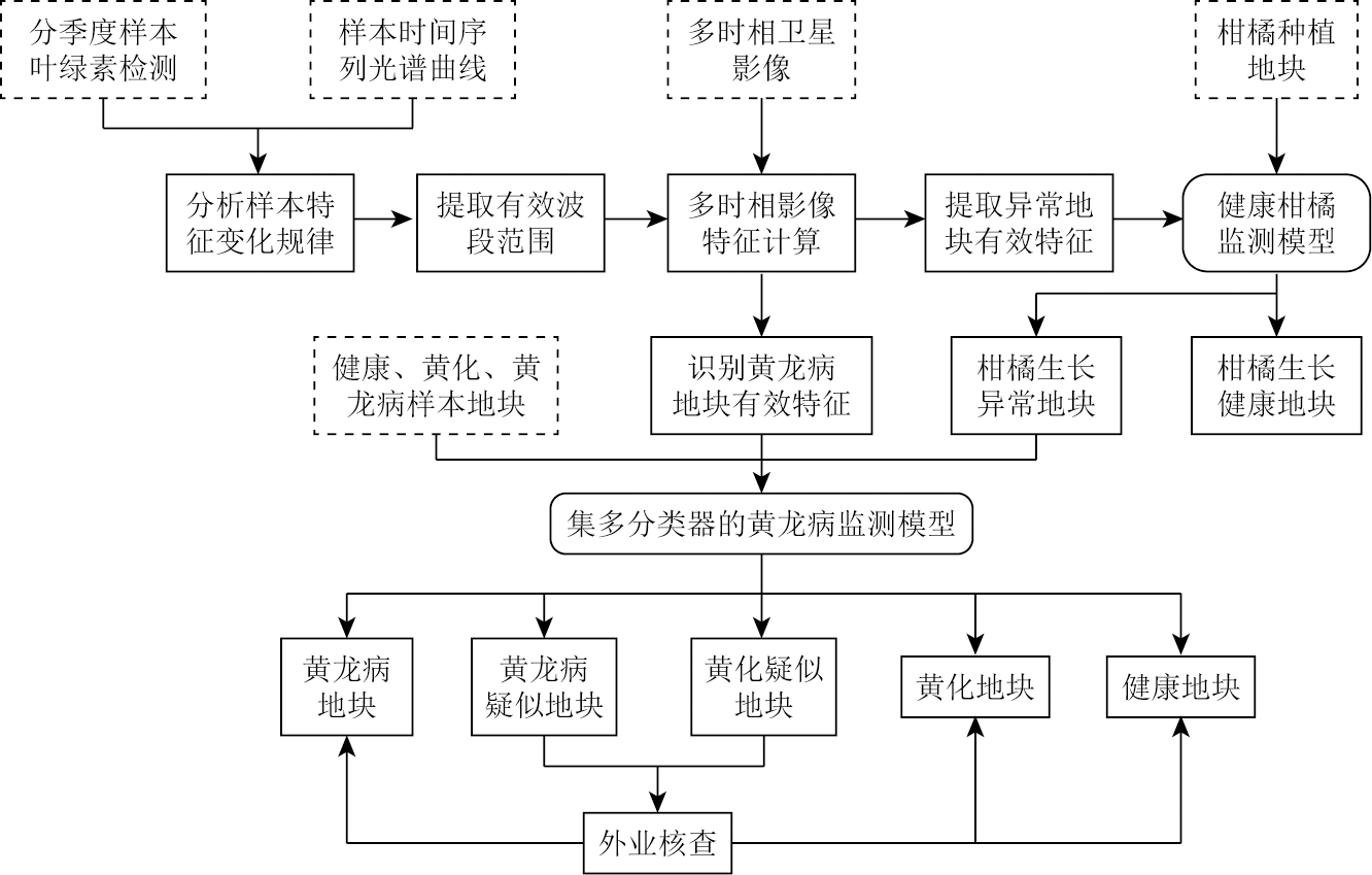
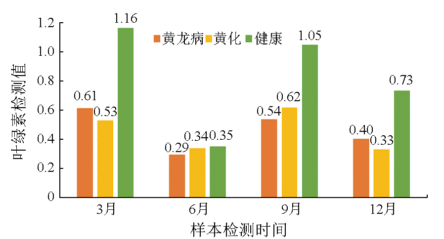
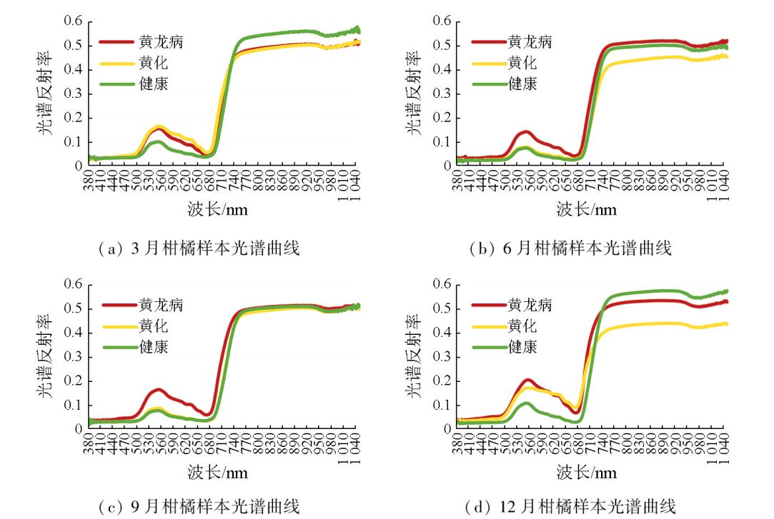
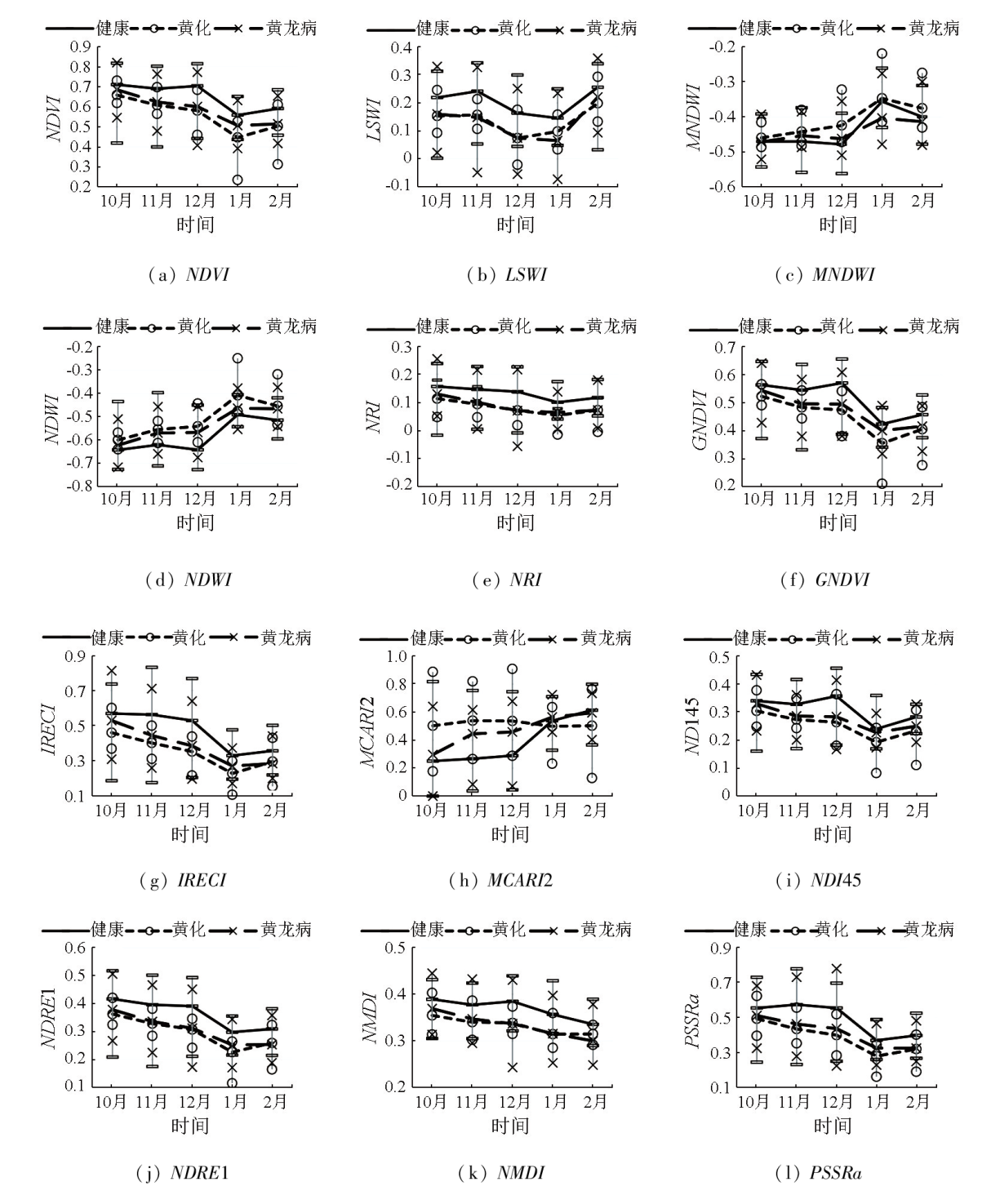
To efficiently monitor citrus greening (also called Huanglongbing in Chinese) at the large plot scale, this study investigated the healthy, yellowing, and Huanglongbing-affected citrus leaves sampled quarterly from the ground in Mengshan County in Guangxi Province. By performing polymerase chain reaction (PCR), chlorophyll content, and hyperspectral detections on these leaf samples, this study analyzed the variation patterns of citrus characteristics under different states, extracting the effective bands and image features for Huanglongbing monitoring. Furthermore, this study constructed a monitoring model for healthy citrus to reduce the objects to be discriminated and identify abnormal citrus growth plots. Finally, this study extracted the Huanglongbing-affected plots using a multi-classifier algorithm based on the effective features from multitemporal Sentinel-2 images. The results of this study indicate that the Huanglongbing-affected and yellowing leaf samples yielded highly similar chlorophyll contents. In March and December, the Huanglongbing-affected citrus exhibited higher chlorophyll content compared to the yellowing citrus. However, the case was the opposite in June and September. The hyperspectral curves suggest that December is a significant period for identifying Huanglongbing and yellowing. The wavelengths ranging from 530 nm to 650 nm and 740 nm to 1050 nm proved effective for diagnosing Huanglongbing and yellowing. The feature indices based on the Sentinel-2 image for December, including the normalized difference vegetation index (NDVI), land surface water index (LSWI), nitrogen reflectance index (NRI), green normalized difference vegetation index (GNDVI), and inverted red edge chlorophyll index (IRECI), could effectively distinguish between healthy and abnormal growth plots of citrus. The feature indices based on the Sentinel-2 images covering periods from October to December and January to February of the following year, including the NDVI, modified normalized difference water index (MNDWI), normalized difference water index (NDWI), GNDVI, inverted red-edge chlorophyll index (IRECI), modified chlorophyll absorption ratio index 2 (MCARI2), normalized difference index based on Landsat bands 4 and 5 (NDI45), and pigment specific simple ratio chlorophyll index (PSSRa), showed advantages in monitoring Huanglongbing. The identification accuracy of Huanglongbing-affected plots in Mengshan County was 86.6 %, with a missed detection rate of 7.8 % and an error rate of 10.4 %. In 2021, Mengshan County held 964 Huanglongbing-affected plots covering an area of 220.13 hm2, with an incidence rate of 2.02 % for large-scale Huanglongbing, mainly concentrated in Xinxu, Wenxu, and Mengshan towns, and Xiayi Yao Township. The combination of satellite remote sensing and ground measurement enables large-scale monitoring of Huanglongbing-affected plots. The monitoring technology in this study provides novel insights for the large-scale monitoring, prevention, and control of Huanglongbing.
XIE Guoxue , HUANG Qiting , YANG Shaoe , LIANG Yongjian , QIN Zelin , SU Qiuqun . Exploring the monitoring technology for Huanglongbing at the plot scale under satellite-ground collaboration[J]. Remote Sensing for Natural Resources, 2025 , 37(2) : 30 -38 . DOI: 10.6046/zrzyyg.2023341
表1 影像多特征指数详情Tab.1 Image multi-feature index details |
| 指数 | 简称 | 全称 | 计算方法 | 描述 | 类型 | 参考文献 |
|---|---|---|---|---|---|---|
| 归一化植被指数 | NDVI | normalized difference vegetation index | (B8-B4)/(B8+B4) | 常用于反映植被长势、健康情况等,覆盖度较低时受裸露土壤干扰 | 传统指数 | [16] |
| 地表水分指数 | LSWI | land surface water index | (B8-B11)/(B8+B11) | 用于监测植被冠层水分含量 | 传统指数 | [17] |
| 改进归一化差异水体指数 | MNDWI | modified normalized difference water index | (B3-B11) /(B3+B11) | 提取水体敏感,有效降低城镇、植被噪音影响 | 传统指数 | [18] |
| 归一化差异水体指数 | NDWI | normalized difference water index | (B3-B8) /(B3+B8) | 最大程度抑制植被的信息,有效突出水体信息 | 传统指数 | [18] |
| 氮反射指数 | NRI | nitrogen reflectance index | (B3-B4) /(B3+B4) | 与叶片氮素含量显著相关,能够反演叶片氮含量的变化情况 | 传统指数 | [19] |
| 绿度归一化植被指数 | GNDVI | green normalized difference vegetative index | (B5-B2) /(B5+B2) | 评估光合活性,用于确定植物冠层吸收水氮常用植被指数 | 红边指数 | [20] |
| 倒红边叶绿素指数 | IRECI | inverted red-edge chlorophyll index | (B7-B4)/(B5/B6) | 与叶绿素含量和叶面积指数相关性好,用于表征叶绿素含量 | 红边指数 | [21] |
| 叶绿素吸收指数 | MCARI2 | modified chlorophyll absorption ratio index 2 | [(B5-B4)-0.2(B5-B3)](B6/B5) | 对植被叶绿素含量敏感,值越高表明叶绿素含量越高 | 红边指数 | [22] |
| 归一化红边指数 | NDI45 | normalized difference index | (B5-B4) /(B5+B4) | 比NDVI线性更强,对监测植被茂盛区有优势 | 红边指数 | [23] |
| 归一化差值红边指数 | NDRE1 | normalized difference red-edge 1 | (B6-B5) /(B6+B5) | 用红边代替NDVI的红边和近红外波段,用于反演植被叶面积指数和叶绿素含量 | 红边指数 | [24] |
| 归一化多波段干旱指 | NMDI | normalized multi -band drought index | [B8A-(B11-B12)]/[B8A+(B11-B12)] | 适用于对土壤与植被水分含量的监测 | 红边指数 | [25] |
| 特征色素简单比值指数 | PSSRa | pigment specific simple ratio(chlorophyll) index | B7/B4 | 用于量化植被冠层色素含量 | 红边指数 | [26] |
表2 蒙山县柑橘黄龙病监测统计表Tab.2 Mengshan County Citrus Huanglongbing monitoring statistics table |
| 乡镇名称 | 面积/hm2 | 地块数量/个 | ||||||
|---|---|---|---|---|---|---|---|---|
| 健康 | 黄龙病 | 生长异常 | 合计 | 健康 | 黄龙病 | 生长异常 | 合计 | |
| 蒙山镇 | 1 064.90 | 28.05 | 18.99 | 1 111.94 | 5 544 | 164 | 86 | 5 794 |
| 西河镇 | 2 277.30 | 10.67 | 8.42 | 2 296.39 | 10 531 | 46 | 36 | 10 613 |
| 新圩镇 | 2 114.12 | 90.43 | 15.78 | 2 220.33 | 9 422 | 360 | 84 | 9 866 |
| 文圩镇 | 2 251.72 | 55.03 | 41.02 | 2 347.77 | 10 750 | 235 | 217 | 11 202 |
| 黄村镇 | 1 103.29 | 7.54 | 7.33 | 1 118.16 | 4 345 | 40 | 38 | 4 423 |
| 陈塘镇 | 942.24 | 1.04 | 0.78 | 944.06 | 4 073 | 7 | 6 | 4 086 |
| 汉豪乡 | 535.23 | 3.17 | 0.67 | 539.07 | 1 847 | 11 | 8 | 1 866 |
| 长坪瑶族乡 | 70.22 | 10.04 | 0.82 | 81.08 | 246 | 35 | 4 | 285 |
| 夏宜瑶族乡 | 232.23 | 14.16 | 7.02 | 253.41 | 1 037 | 66 | 30 | 1 133 |
| 合计 | 10 591.25 | 220.13 | 100.83 | 10 912.21 | 47 795 | 964 | 509 | 49 268 |
| [1] |
谢国雪, 黄启厅, 杨绍锷, 等. 基于中高分影像的丘陵区柑橘种植地块提取[J]. 南方农业学报, 2021, 52(12):3454-3462.
|
| [2] |
白先进, 赵小龙, 娄兵海, 等. 回顾广西柑橘黄龙病防控(1982-2020)[J]. 南方园艺, 2020, 31(6):5-16.
|
| [3] |
鹿连明, 范国成, 胡秀荣, 等. 田间柑橘植株不同部位黄龙病菌的PCR检测及发病原因分析[J]. 植物保护, 2011, 37(2):45-49.
|
| [4] |
翁海勇, 何城城, 许金钗, 等. 叶绿素荧光成像技术下的柑橘黄龙病快速诊断[J]. 农业工程学报, 2020, 36(12):196-203.
|
| [5] |
柏自琴, 周常勇. 柑橘黄龙病病原分化及发生规律研究进展[J]. 中国农学通报, 2012, 28(1):133-137.
|
| [6] |
余继华, 汪恩国, 杨晓, 等. 柑橘黄龙病老龄果园发病力与时序发生规律研究[J]. 农学学报, 2017, 7(4):10-14.
|
| [7] |
|
| [8] |
梅慧兰, 邓小玲, 洪添胜, 等. 柑橘黄龙病高光谱早期鉴别及病情分级[J]. 农业工程学报, 2014, 30(9):140-147.
|
| [9] |
|
| [10] |
兰玉彬, 朱梓豪, 邓小玲, 等. 基于无人机高光谱遥感的柑橘黄龙病植株的监测与分类[J]. 农业工程学报, 2019, 35(3):92-100.
|
| [11] |
黄梓效. 基于地-空多源遥感的柑橘黄龙病智能识别技术的研究[D]. 广州: 华南农业大学, 2020.
|
| [12] |
|
| [13] |
何城城. 波谱成像技术下的柑橘黄龙病快速检测方法及设备研发[D]. 福州: 福建农林大学, 2022.
|
| [14] |
范世达, 马伟荣, 姜文博, 等. 基于深度学习的柑橘黄龙病远程诊断技术初探[J]. 中国果树, 2022(4):76-79,86,133.
|
| [15] |
谢国雪, 黄启厅, 杨绍锷, 等. 基于遥感影像的丘陵区柑橘种植地块监测方法及系统:中国,CN111709379B[P]. 2023-04-18.
|
| [16] |
梁锦涛, 陈超, 张自力, 等. 一种融合指数与主成分分量的随机森林遥感图像分类方法[J]. 自然资源遥感, 2023, 35 (3):35-42.doi:10.6046/zrzyyg.2022493.
|
| [17] |
|
| [18] |
徐涵秋. 利用改进的归一化差异水体指数(MNDWI)提取水体信息的研究[J]. 遥感学报, 2005, 9(5):589-595.
|
| [19] |
|
| [20] |
刘伟, 杨共强, 徐飞, 等. 近地高光谱和低空航拍数字图像遥感监测小麦条锈病的比较研究[J]. 植物病理学报, 2018, 48(2):223-227.
|
| [21] |
|
| [22] |
|
| [23] |
|
| [24] |
|
| [25] |
张红卫, 陈怀亮, 周官辉, 等. 归一化多波段干旱指数在农田干旱监测中的应用[J]. 科技导报, 2009, 27(11):23-26.
|
| [26] |
|
/
| 〈 |
|
〉 |
