
Remote Sensing for Natural Resources >
Exploring the performance of riparian zones in reducing non-point source pollution by coupling remote sensing with the SWAT model
Received date: 2022-11-17
Revised date: 2023-03-14
Online published: 2026-06-03
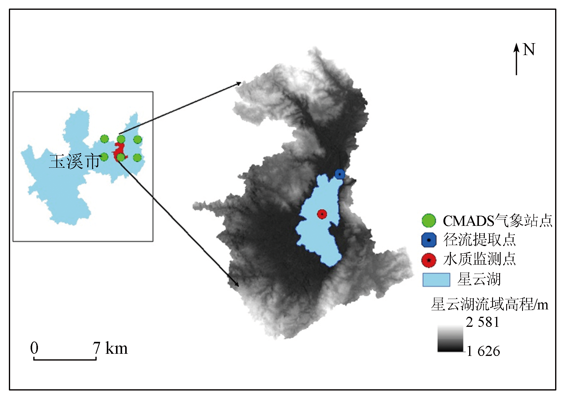
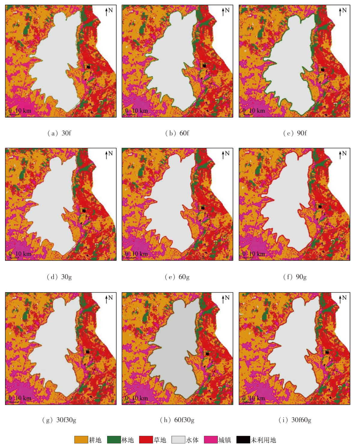
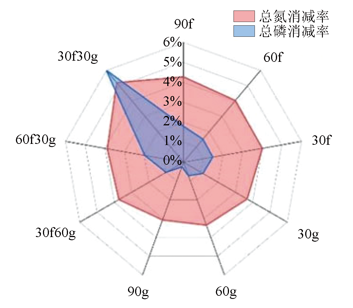
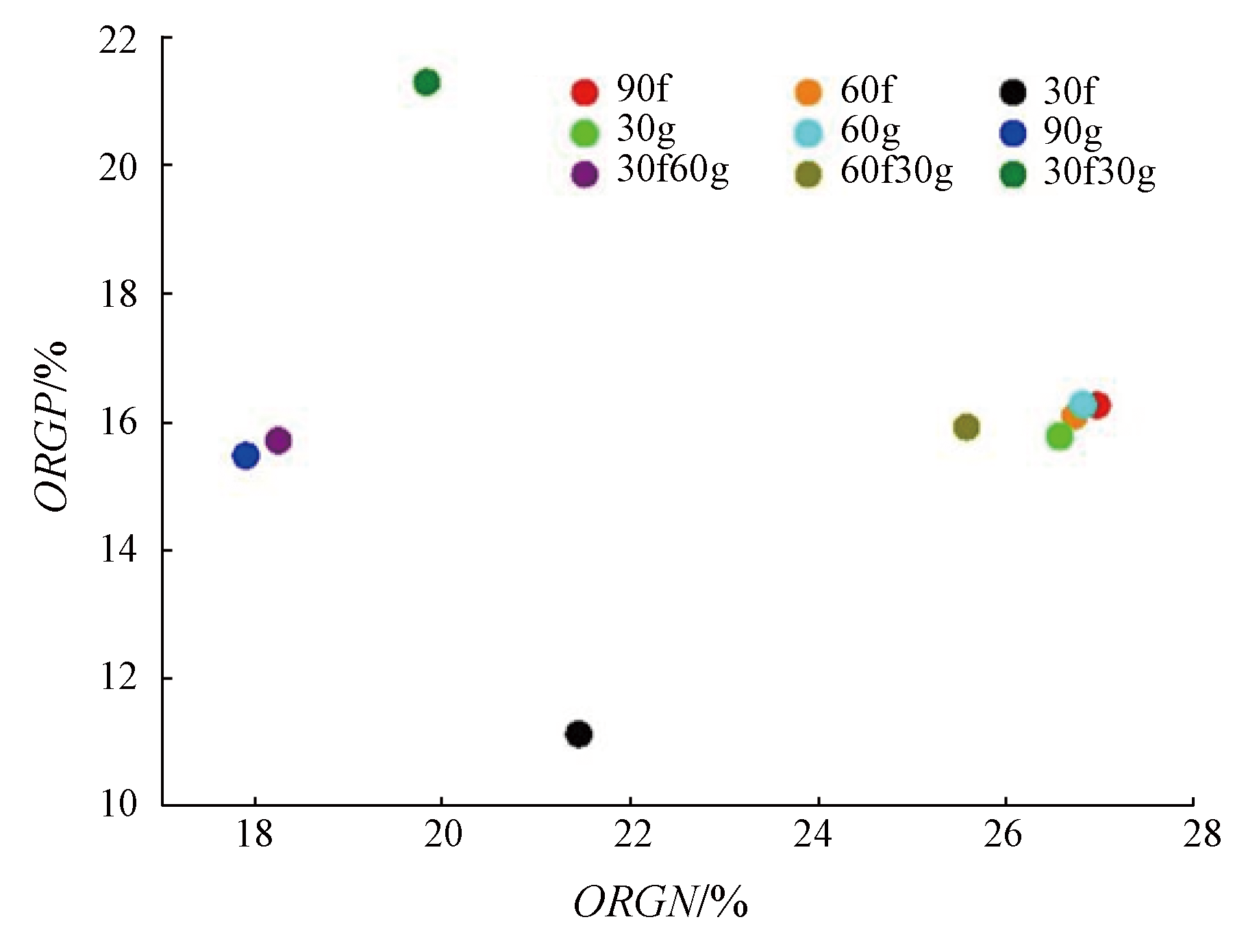
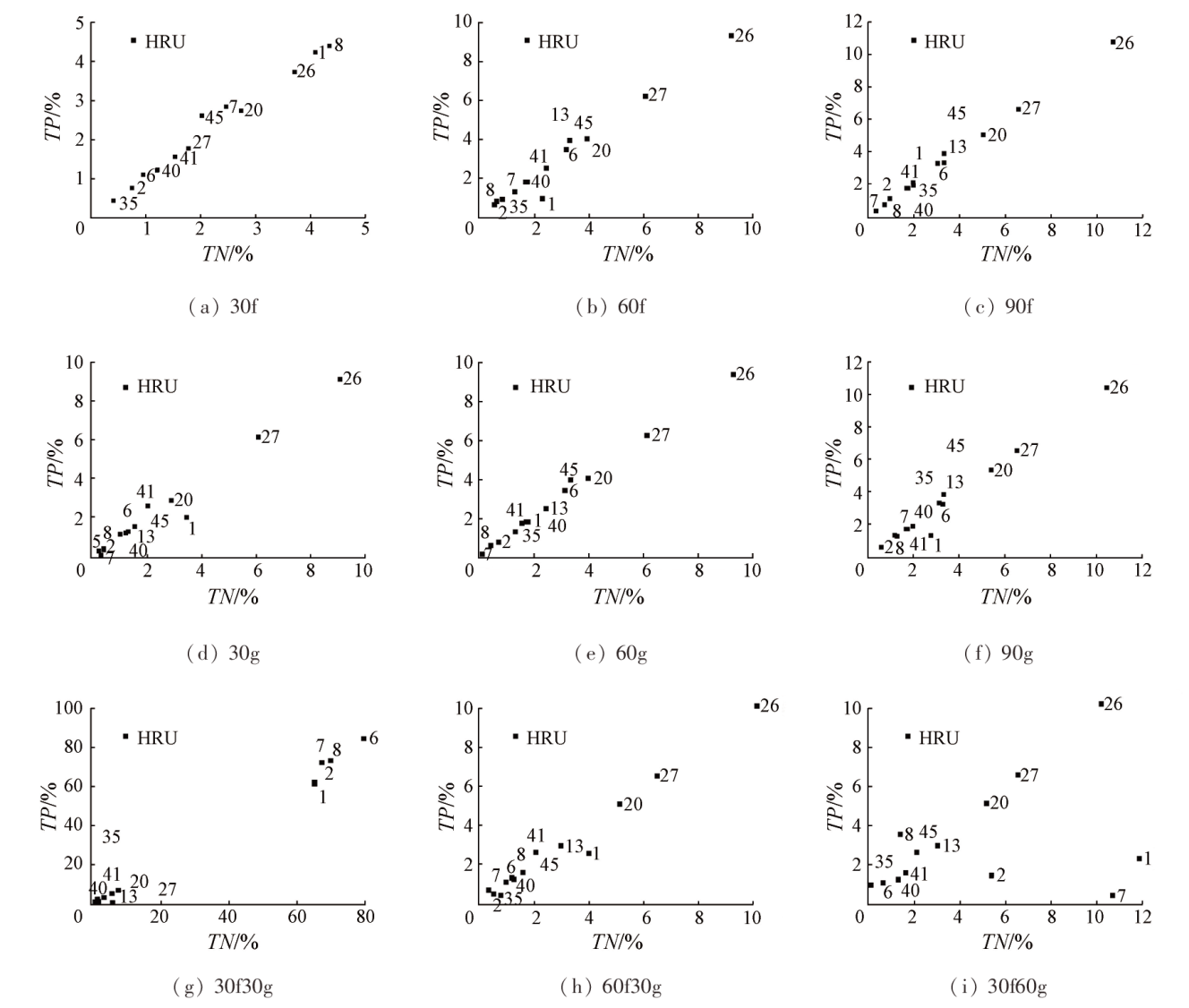
Riparian zones have been extensively used in non-point source pollution control projects worldwide, and remote sensing has gradually become a significant means of non-point source pollution research. However, combining remote sensing technology with riparian zones for efficient pollution interception effects is still a challenge. With the Xingyun Lake basin in Yunnan Province as the study area, this study established a soil and water assessment tool (SWAT) model by coupling with remote sensing. It created a riparian zone by changing the land use type for scenario simulation, investigating the different effects of various widths and vegetation types on pollutant reduction. The key findings are as follows: ①The created riparian zone exhibited better interception effects for nitrogen compared to phosphorus; ② Concerning different vegetation types in the riparian zone, forest land manifested significantly better pollution interception effects than grassland. Moreover, the pollutant reduction rate gradually increased with an increase in the width of the riparian zone; ③A riparian zone consisting of 30-m-wide forest land and 30-m-wide grassland can reduce total nitrogen production by 5.20% and total phosphorus production by 6.03% while intercepting 19.83% of organic nitrogen and 21.30% of organic phosphorus into the lake, demonstrating the optimal pollution interception effects.
Key words: SWAT; non-point source pollution; land use; riparian zone; remote sensing
LIU Yiyao , WU Taixia , WANG Shudong , JU Maosen . Exploring the performance of riparian zones in reducing non-point source pollution by coupling remote sensing with the SWAT model[J]. Remote Sensing for Natural Resources, 2025 , 37(2) : 256 -264 . DOI: 10.6046/zrzyyg.2022439
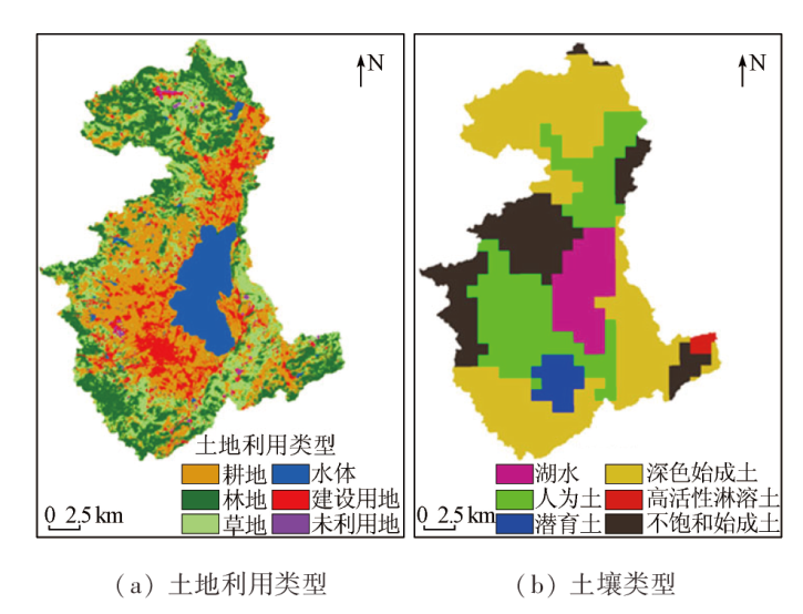
表1 SWAT模型输入数据表Tab.1 SWAT model input data |
| 数据类型 | 数据名称 | 格式 | 数据内容 | 来源 |
|---|---|---|---|---|
| 空间数据 | DEM | grid | 高程、坡度、坡向 | 地理空间数据云 |
| 土地 利用 | grid | 土地利用类型 | FROM-GLC 2017v1 | |
| 土壤 类型 | grid | 土壤类型 | 世界土壤数据库HWSD | |
| 水文 数据 | grid | 每月径流量 | ECMWF River discharge and related historical data from the Global Flood Awareness System数据集 | |
| 属性数据 | 土壤 属性 | DBase表 | 土壤密度、饱和导水率、持水率、颗粒含量等 | 世界土壤数据库HWSD |
| 气象 数据 | txt | 最高最低气温、日降雨量、相对湿度、太阳辐射、风速等 | CMADS数据集 | |
| 水质 数据 | txt | 总氮、总磷 | 监测站点实测 |
表2 径流参数敏感性及取值结果Tab.2 Sensitivity of runoff parameters and results of taking values |
| 敏感性 排序 | 参数① | 定义 | 所在 位置 | 范围 | 取值 |
|---|---|---|---|---|---|
| 1 | v_ALPHA_BF | 基流α系数 | .gw | -0.164 8~ 0.224 8 | 0.049 48 |
| 2 | v_SFTMP | 降雪气温 | .bsn | -0.336 36~ 3.583 | 2.733 80 |
| 3 | v_GW_DELAY | 地下水滞后系数 | .gw | 289.07~ 526.75 | 435.639 00 |
| 4 | r_GW_REVAP | 地下水再蒸发系数 | .gw | -1.482~ -0.485 | -0.767 20 |
| 5 | r_SURLAG | 地表径流滞后系数 | .bsn | -0.056~ 0.034 | 0.026 50 |
①修改方式r代表模型参数值乘以率定取值; v代表将模型参数值替换为率定取值。 |
表3 总氮总磷参数敏感性及取值结果Tab.3 Sensitivity of total nitrogen and total phosphorus parameters and results of taking values |
| 敏感性 排序 | 参数 | 定义 | 所在 位置 | 范围 | 取值 |
|---|---|---|---|---|---|
| 1 | v_ERORGP | 有机磷富集率 | .hru | 2.208 23~ 6.958 44 | 5.794 64 |
| 2 | r_CANMX | 最大树冠蓄水量 | .hru | -0.388 16~ 0.216 73 | 0.110 88 |
| 3 | r_USLE_P | USLE方程水土保持措施因子 | .mgt | -0.818~ 0.075 15 | -0.322 30 |
| 4 | v_CDN | 反硝化指数速率系数 | .bsn | 1.407 31~ 4.335 55 | 3.178 90 |
| 5 | r_OV_N | 地面流量的曼宁n值 | .hru | -0.430 43~ 0.201 86 | 0.135 45 |
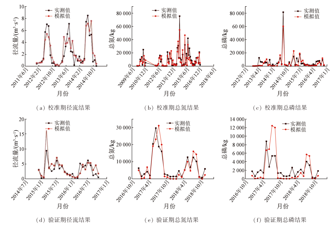
图4 径流、总氮、总磷校准期和验证期实测值和模拟值拟合结果Fig.4 Results of fitting the measured and simulated values of runoff, total nitrogen and total phosphorus during the calibration and validation periods |
表4 星云湖流域各变量月尺度模拟校准和验证结果Tab.4 Calibration and validation results of monthly-scale simulations for each variable in the Xingyun Lake watershed |
| 变量 | 校准期 | 验证期 | ||
|---|---|---|---|---|
| NSE | NSE | |||
| 径流 | 0.79 | 0.78 | 0.70 | 0.64 |
| 总氮 | 0.80 | 0.79 | 0.84 | 0.78 |
| 总磷 | 0.86 | 0.83 | 0.64 | 0.56 |
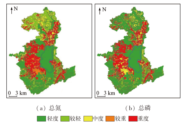
表5 关键源区等级划分表Tab.5 Critical source area classification (kg/hm2) |
| 流失强度 | 总氮 | 总磷 |
|---|---|---|
| 轻度 | [0,4.706) | [0,1.980) |
| 较轻 | [4.706,10.276) | [1.980,5.121) |
| 中度 | [10.276,15.195) | [5.121,6.605) |
| 较重 | [15.195,21.226) | [6.605,7.952) |
| 重度 | [21.226,55.704] | [7.952,14.564] |
| [1] |
朱兆良, 孙波, 杨林章, 等. 我国农业面源污染的控制政策和措施[J]. 科技导报, 2005, 23(4):47-51.
|
| [2] |
叶兆木, 彭瑶, 赵芳, 等. 水环境现状调查及评估方法分析[J]. 环境影响评价, 2020, 42(3):92-96.
|
| [3] |
国家统计局. 第一次全国污染源普查公报[R]. 北京, 2010.
National Bureau of Statistics. Bulletin of the first national pollution source survey[R]. Beijing, 2010.
|
| [4] |
国家发展和改革委员会, 环境保护部, 住房和城乡建设部, 等. 太湖流域水环境综合治理总体方案(2013年修编)[EB/OL]. https://www.ndrc.gov.cn/fzggw/jgsj/dqs/sjdt/201401/W020190909483338371074.pdf
National Development and Reform Commission, Ministry of Environmental Protection, Ministry of Housing and Urban Rural Development, et al. Overall plan for comprehensive treatment of water environment in Taihu Lake basin (revised in 2013) [EB/OL]. https://www.ndrc.gov.cn/fzggw/jgsj/dqs/sjdt/201401/W020190909483338371074.pdf
|
| [5] |
|
| [6] |
|
| [7] |
|
| [8] |
|
| [9] |
|
| [10] |
|
| [11] |
夏军, 翟晓燕, 张永勇. 水环境非点源污染模型研究进展[J]. 地理科学进展, 2012, 31(7):941-952.
|
| [12] |
|
| [13] |
常舰. 基于SWAT模型的最佳管理措施(BMPs)应用研究——以西苕溪流域为例[D]. 杭州: 浙江大学, 2017.
|
| [14] |
|
| [15] |
|
| [16] |
王敏, 张雨桐, 李奇宸, 等. 安徽省兆河流域非点源污染模拟及最佳管理措施[J]. 水土保持通报, 2021, 41(5):127-136,153.
|
| [17] |
云南省统计局. 云南统计年鉴-2019(总第35期)[M]. 北京: 中国统计出版社, 2019.
Yunnan Provincial Bureau of Statistics. Yunnan statistical yearbook-2019[M]. Beijing: China Statistics Press, 2019.
|
| [18] |
陈杨. 星云湖水体环境与氮磷空间分布特征研究[D]. 昆明: 云南师范大学, 2020.
|
| [19] |
云南省环境保护厅. 1998—2018云南省环境状况公报[EB/OL]. http://sthjt.yn.gov.cn/hjzl/hjzkgb/
Yunnan Provincial Department of Environmental Protection. 1998-2018Yunnan environmental status bulletin[EB/OL]. http://sthjt.yn.gov.cn/hjzl/hjzkgb/
|
| [20] |
|
| [21] |
|
| [22] |
|
| [23] |
郭伟, 陈兴伟, 林炳青. SWAT模型参数对土地利用变化的响应及其对不同时间尺度径流模拟的影响[J]. 生态学报, 2021, 41(16):6373-6383.
|
| [24] |
张招招, 程军蕊, 毕军鹏, 等. 甬江流域土地利用方式对面源磷污染的影响:基于SWAT模型研究[J]. 农业环境科学学报, 2019, 38(3):650-658.
|
| [25] |
|
| [26] |
陈海涛, 曹向真. 基于SUFI-2参数最适置信区间的参数优化方法结果对比分析[J]. 节水灌溉, 2021(6):24-30.
|
| [27] |
李振炜, 于兴修, 姚孝友, 等. 农业非点源污染关键源区识别方法研究进展[J]. 生态学杂志, 2011, 30(12):2907-2914.
|
| [28] |
朱鹤健, 陈健飞, 陈松林, 等. 土壤地理学[M].2版. 北京: 高等教育出版社, 2010.
|
| [29] |
|
| [30] |
|
| [31] |
|
| [32] |
汤家喜, 孙丽娜, 孙铁珩, 等. 河岸缓冲带对氮磷的截留转化及其生态恢复研究进展[J]. 生态环境学报, 2012, 21(8):1514-1520.
|
| [33] |
申小波. 草本植被过滤带对主要农业面源污染物的拦截效果研究[D]. 长沙: 中南林业科技大学, 2014.
|
| [34] |
何聪. 混播草皮缓冲带农业面源污染拦截效果的试验研究[D]. 扬州: 扬州大学, 2012.
|
/
| 〈 |
|
〉 |