
Remote Sensing for Natural Resources >
Analysis of surface albedo responses to forest fires in the Great Xing’an Range, China
Received date: 2023-10-31
Revised date: 2024-02-05
Online published: 2026-06-03
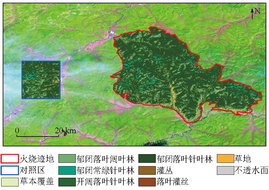
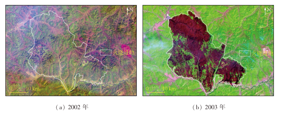
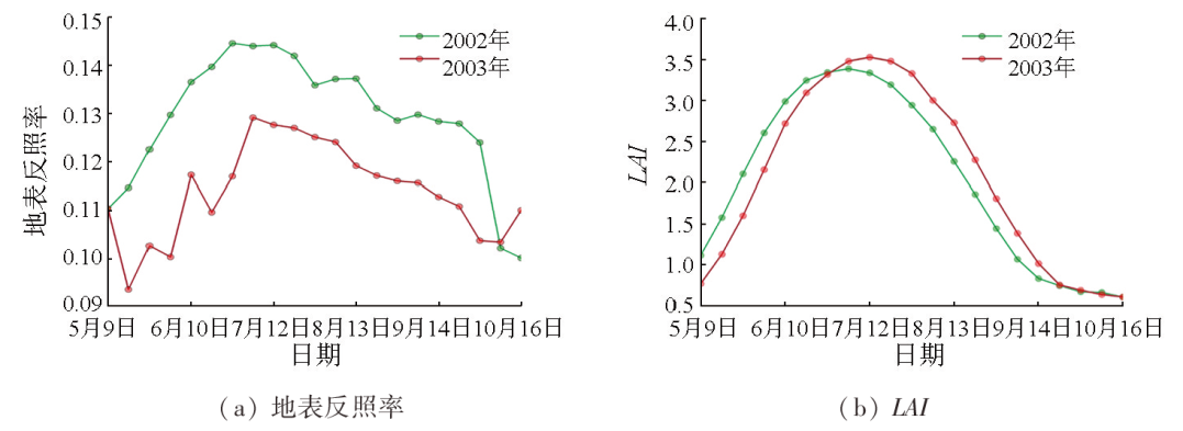
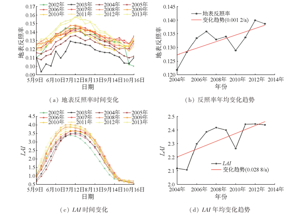
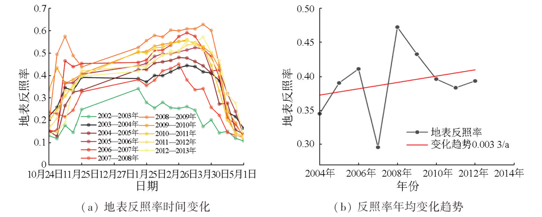
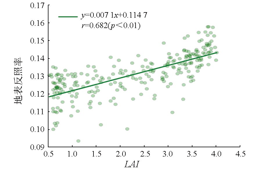
To explore the surface albedo responses to forest fires in the Great Xing’an Range, China, this study investigated the forest fire occurring in the zone under the supervision of the Jinhe Forestry Bureau on May 5, 2003. The changes in the surface albedo after the forest fire were analyzed based on the global land surface satellite (GLASS)-derived surface albedo and leaf area index (LAI) data. The results indicate that the surface albedo in the burned zone decreased in the short term (1 a) but increased significantly at a rate of 0.001 2/a in the mid- to-long term (10 a). The increasing trend in the surface albedo was slightly influenced by contemporaneous climate changes and human activities but was closely associated with the vegetation restoration process after the forest fire. Moreover, the increase in the surface albedo in the burned zone was highly correlated with LAI increase (r=0.682, p<0.01). Additionally, the vegetation masking effect further enhanced the increasing trend in surface albedo in the burned zone during the snow-covered period. Overall, the results of this study deepen the understanding of spatiotemporal variations in the surface albedo, laying a foundation for thoroughly assessing the influence of forest fires on global climate changes.
CHEN Xuejiao , ZHANG Kaitong , WANG Jiao , WANG Munan , QU Ying . Analysis of surface albedo responses to forest fires in the Great Xing’an Range, China[J]. Remote Sensing for Natural Resources, 2025 , 37(2) : 212 -219 . DOI: 10.6046/zrzyyg.2023322
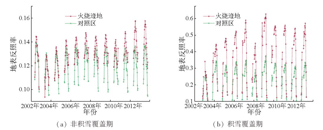
图3 森林火灾发生前后年份(2002年和2003年)火烧迹地非积雪覆盖期地表反照率和LAI随时间变化Fig.3 Temporal changes of surface albedo and LAI in the burned area before and after forest fire (2002 and 2003) during non-snow covered period |
图7 2002—2013年非积雪覆盖期地表反照率和LAI的相关关系Fig.7 Correlation between surface albedo and LAI during non-snow cover period from 2002 to 2013 |
表1 2002—2013年地表反照率与LAI的相关系数Tab.1 Correlation coefficients between surface albedo and LAI from 2002 to 2013 |
| 年份 | 相关系数r | 年份 | 相关系数r |
|---|---|---|---|
| 2002年(火灾发生前) | 0.797**① | 2008年 | 0.916** |
| 2003年 | 0.733** | 2009年 | 0.853** |
| 2004年 | 0.923** | 2010年 | 0.781** |
| 2005年 | 0.772** | 2011年 | 0.883** |
| 2006年 | 0.816** | 2012年 | 0.865** |
| 2007年 | 0.805** | 2013年 | 0.944** |
①**代表相关分析结果为99%置信。 |
| [1] |
|
| [2] |
|
| [3] |
|
| [4] |
|
| [5] |
|
| [6] |
|
| [7] |
|
| [8] |
|
| [9] |
|
| [10] |
|
| [11] |
|
| [12] |
|
| [13] |
|
| [14] |
包月梅, 孙紫英, 赵鹏武, 等. 基于遥感数据的根河市火烧迹地植被覆盖度时空分析[J]. 东北林业大学学报, 2015, 43(11):62-69,74.
|
| [15] |
田成明, 陈志, 高小红. 基于Landsat5 TM的祁连山区蒸散发遥感估算——以青海祁连县为例[J]. 青海师范大学学报(自然科学版), 2014, 30(2):49-56.
|
| [16] |
雷浩川, 刘尊方, 于晓晶, 等. 基于Landsat5影像的青海省大通县土壤表层全氮空间格局反演[J]. 青海大学学报, 2021, 39(6):79-86.
|
| [17] |
李静, 宫阿都, 陈艳玲, 等. 森林过火区植被遥感参数的变化与恢复特征分析[J]. 地球信息科学学报, 2018, 20(3):368-376.
|
| [18] |
|
| [19] |
|
| [20] |
|
| [21] |
|
| [22] |
|
| [23] |
|
| [24] |
|
| [25] |
|
| [26] |
|
| [27] |
|
| [28] |
|
| [29] |
|
| [30] |
|
| [31] |
|
| [32] |
|
/
| 〈 |
|
〉 |