
Remote Sensing for Natural Resources >
Comprehensive assessment and analysis of natural resources and ecological conditions in the Zhangbei area
Received date: 2023-12-13
Revised date: 2024-03-04
Online published: 2026-06-03
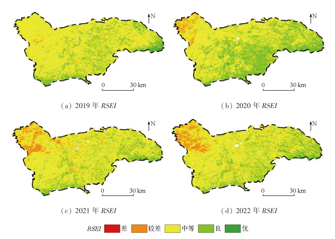
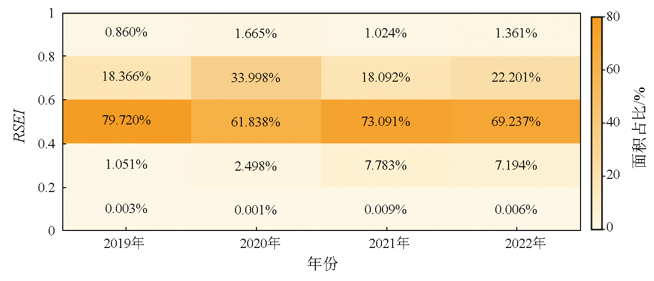
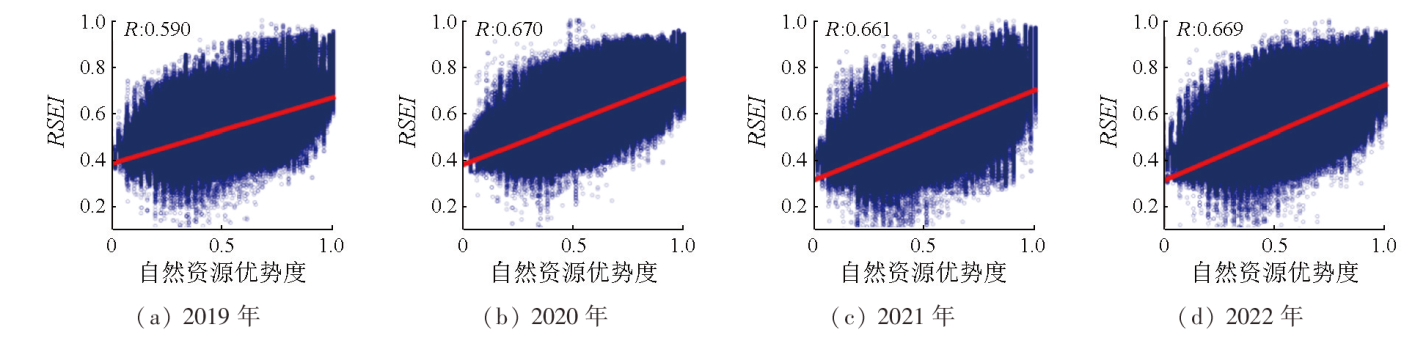
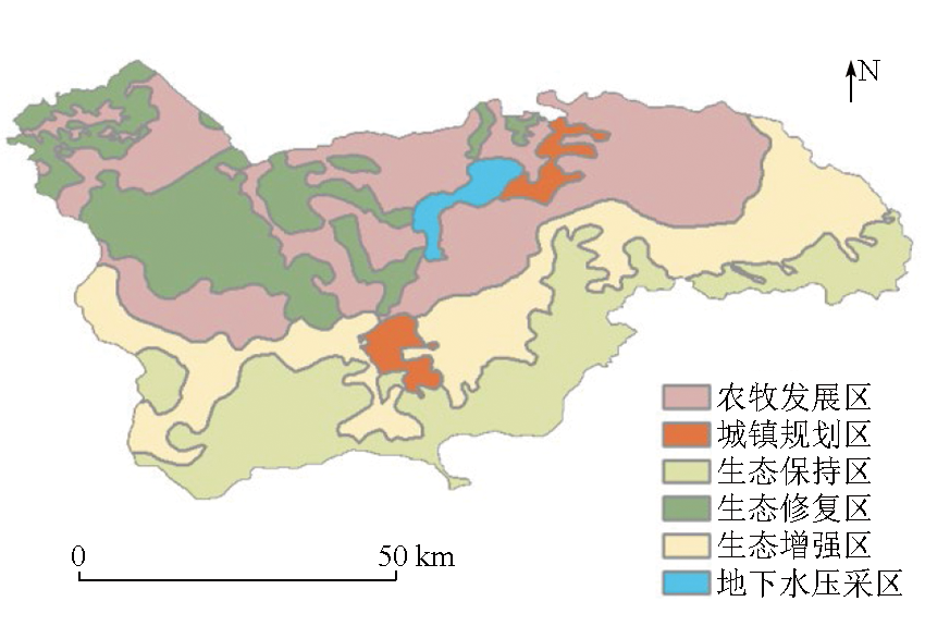
This study aims to explore the background conditions of the natural resource elements and the dynamic distribution of ecological conditions in typical agricultural and pastoral intertwined zones. Focusing on the Zhangbei area, this study selected 15 assessment factors by comprehensively considering four types of resources: land, vegetation, groundwater, and minerals. Accordingly, this study conducted a comprehensive assessment of natural resource elements in the study area using the analytic hierarchy process (AHP). Meanwhile, the 2019—2022 average remote sensing ecological index (RSEI) values were calculated using the Google Earth Engine platform. Based on these results, the study area is divided into six ecological functional zones. The results indicate that from 2019 to 2022, the natural resource dominance and RSEI values of the study area showed a gradual decreasing trend from the low mountainous area encircling the southern part to the hilly area in the northwestern part. The study area exhibited moderate natural resource dominance, with RSEI values all exceeding 0.52. This suggests relatively favorable ecological conditions. In addition, the assessment results of natural resource dominance are closely related to RSEI, showing a positive correlation spatially. This verifies the importance of the background conditions of natural resource elements on ecological status. The ecological function zoning proposed in this study can serve as a scientific reference for the planning and development of Zhangbei areas.
ZHANG Jing , HU Xiaojia , WANG Wei , CHEN Donglei , HUANG Xuhong , YANG Junquan . Comprehensive assessment and analysis of natural resources and ecological conditions in the Zhangbei area[J]. Remote Sensing for Natural Resources, 2025 , 37(2) : 164 -172 . DOI: 10.6046/zrzyyg.2023369
表1 自然资源要素指标分级体系Tab.1 Classification system for indicators of natural resource elements |
| 要素 | 因子 | 无/不好影响(1分) | 一般(3分) | 较好(5分) | 极好(7分) | 因子权重 |
|---|---|---|---|---|---|---|
| 土地 资源 | 土地利用分类 | 城镇村及工矿用地、 交通运输用地 | 水浇地、旱地、其他林地、其他草地、其他用地 | 灌木林地、人工牧草地、种植园用地 | 乔木林地、天然牧草地、湿地、水域 | 0.072 |
| 土壤类型 | 碱化盐土、草甸碱土、碱化栗钙土、盐化草甸土、盐化栗钙土 | 草原风沙土、中性石质土、钙质粗骨土、石灰性草甸土、栗钙土 | 褐土、淋溶褐土、灰褐土、栗褐土、潜育草甸土、暗栗钙土、草甸栗钙土 | 湖积泥质土(水体) | 0.017 | |
| 土壤养分质量地球化学等级 | 较缺乏 | 中等 | 较丰富 | 丰富 | 0.035 | |
| 土壤质量地球化学综合等级 | 四等 | 三等 | 二等 | 一等 | 0.035 | |
| 盐碱质荒漠化 | 重度 | 中度 | 轻度 | 无盐渍化 | 0.121 | |
| 植被 资源 | 归一化植被指数 | ≤-0.37 | (-0.37,-0.21] | (-0.21,0] | (0,0.56] | 0.060 |
| 森林蓄积量 | ≤-60 | (-60,25] | (25,33] | (33,60] | 0.120 | |
| 草原生物量 | [0,600] | (600,1 200] | (1 200,1 800] | (1 800,3 000] | 0.120 | |
| 地下水 资源 | 地表水质量 | Ⅴ级 | Ⅵ级 | Ⅲ级 | Ⅱ级 | 0.060 |
| 地下水开发潜力 | 中度、轻度超采区、空白区 | 采补平衡区 | 较小潜力区 | 中度潜力区 | 0.023 | |
| 地下水质量评价 | Ⅴ类 | Ⅵ类 | Ⅲ类 | / | 0.060 | |
| 地下水位 | 地下水位降落漏斗区 | / | 其他地区 | / | 0.157 | |
| 矿产 资源 | 开采矿种 | 能源矿产 | 金属矿产 | 非金属矿产 | 无开发 | 0.040 |
| 开采规模 | 大型 | 中型 | 小型 | / | 0.040 | |
| 开采状态 | 在采 | 停采 | 未利用 | / | 0.040 |
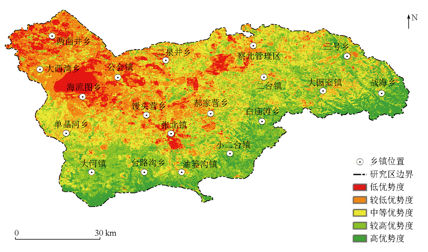
图2 研究区自然资源优势度评价结果Fig.2 Evaluation results of natural resource dominance in the study area |
表2 自然资源优势度区域统计分析结果Tab.2 Regional statistical results of natural resource dominance |
| 序号 | 区域名称 | 评价结果 | 评价等级 | 序号 | 区域名称 | 评价结果 | 评价等级 |
|---|---|---|---|---|---|---|---|
| 1 | 两面井乡 | 0.361 | 较低优势度 | 11 | 单晶河乡 | 0.553 | 中等优势度 |
| 2 | 公会镇 | 0.380 | 较低优势度 | 12 | 三号乡 | 0.599 | 较高优势度 |
| 3 | 海流图乡 | 0.401 | 较低优势度 | 13 | 油篓沟镇 | 0.631 | 较高优势度 |
| 4 | 大西湾乡 | 0.414 | 较低优势度 | 14 | 大囫囵镇 | 0.631 | 较高优势度 |
| 5 | 馒头营乡 | 0.459 | 较低优势度 | 15 | 小二台镇 | 0.653 | 较高优势度 |
| 6 | 张北镇 | 0.466 | 中等优势度 | 16 | 大河镇 | 0.662 | 较高优势度 |
| 7 | 二泉井乡 | 0.475 | 中等优势度 | 17 | 白庙滩乡 | 0.668 | 较高优势度 |
| 8 | 郝家营乡 | 0.511 | 中等优势度 | 18 | 台路沟乡 | 0.701 | 较高优势度 |
| 9 | 二台镇 | 0.516 | 中等优势度 | 19 | 战海乡 | 0.732 | 高优势度 |
| 10 | 察北管理区 | 0.518 | 中等优势度 |
| [1] |
沈镭, 钟帅, 胡纾寒. 新时代中国自然资源研究的机遇与挑战[J]. 自然资源学报, 2020, 35(8):1773-1788.
|
| [2] |
蔡玉梅, 孟超, 周建春, 等. 陆域自然资源综合评价指标体系研究[J]. 测绘科学, 2022, 47(10):168-175.
|
| [3] |
任春秋, 董斌, 许海锋, 等. 环巢湖自然资源综合评价[J]. 贵州师范大学学报(自然科学版), 2022, 40(6):76-81.
|
| [4] |
邱倩倩, 钟丽蓉, 宋玉兵. 江苏省自然资源综合分析评价方法研究[J]. 测绘科学, 2022, 47(8):70-78.
|
| [5] |
赵忠琦, 初道忠. 基于主成分分析法对矿产资源自然禀赋综合评价的研究[J]. 中国矿业, 2019, 28(1):52-57,91.
|
| [6] |
刘立程, 孙中孝, 孟超, 等. 中国农业自然资源评价指标体系构建研究[J]. 农业资源与环境学报, 2023, 40(2):468-478.
|
| [7] |
王冲, 张景, 彭博, 等. 基于“双评价”的国土空间格局优化研究——以江西省安远县为例[J]. 华北地质, 2023, 46(2):69-78.
|
| [8] |
刘宏伟, 王国明, 马传明, 等. 沉积平原区地下空间开发利用适宜性评价指标体系研究——以北京通州区和河北廊坊北三县为例[J]. 华北地质, 2022, 45(4):68-74.
|
| [9] |
马小雷, 孟军省, 付丹平. 典型生态脆弱区环境地质问题及防治对策研究——以河北坝上地区为例[J]. 地下水, 2020, 42(2):122-126.
|
| [10] |
许月卿, 赵菲菲, 孙丕苓. 生态脆弱区土地生态安全动态评价——以河北省张家口市为例[J]. 水土保持通报, 2015, 35(5):232-238.
|
| [11] |
|
| [12] |
张雅, 尹小君, 王伟强, 等. 基于Landsat8 OLI遥感影像的天山北坡草地地上生物量估算[J]. 遥感技术与应用, 2017, 32(6):1012-1021.
|
| [13] |
徐婷, 曹林, 佘光辉. 基于Landsat8 OLI的特征变量优化提取及森林生物量反演[J]. 遥感技术与应用, 2015, 30(2):226-234.
|
| [14] |
张晓东, 刘湘南, 赵志鹏, 等. 基于层次分析法的盐池县地质灾害危险性评价[J]. 国土资源遥感, 2019, 31(3):183-192.doi:10.6046/gtzyyg.2019.03.23.
|
| [15] |
徐涵秋. 城市遥感生态指数的创建及其应用[J]. 生态学报, 2013, 33(24):7853-7862.
|
| [16] |
宋慧敏, 薛亮. 基于遥感生态指数模型的渭南市生态环境质量动态监测与分析[J]. 应用生态学报, 2016, 27(12):3913-3919.
|
| [17] |
陈炜, 黄慧萍, 田亦陈, 等. 基于Google Earth Engine平台的三江源地区生态环境质量动态监测与分析[J]. 地球信息科学学报, 2019, 21(9):1382-1391.
|
| [18] |
王渊, 赵宇豪, 吴健生. 基于Google Earth Engine云计算的城市群生态质量长时序动态监测——以粤港澳大湾区为例[J]. 生态学报, 2020, 40(23):8461-8473.
|
| [19] |
|
/
| 〈 |
|
〉 |