
Remote Sensing for Natural Resources >
An intelligent platform for extracting patches from multisource domestic satellite images and its application
Received date: 2024-02-02
Revised date: 2024-06-14
Online published: 2026-06-03
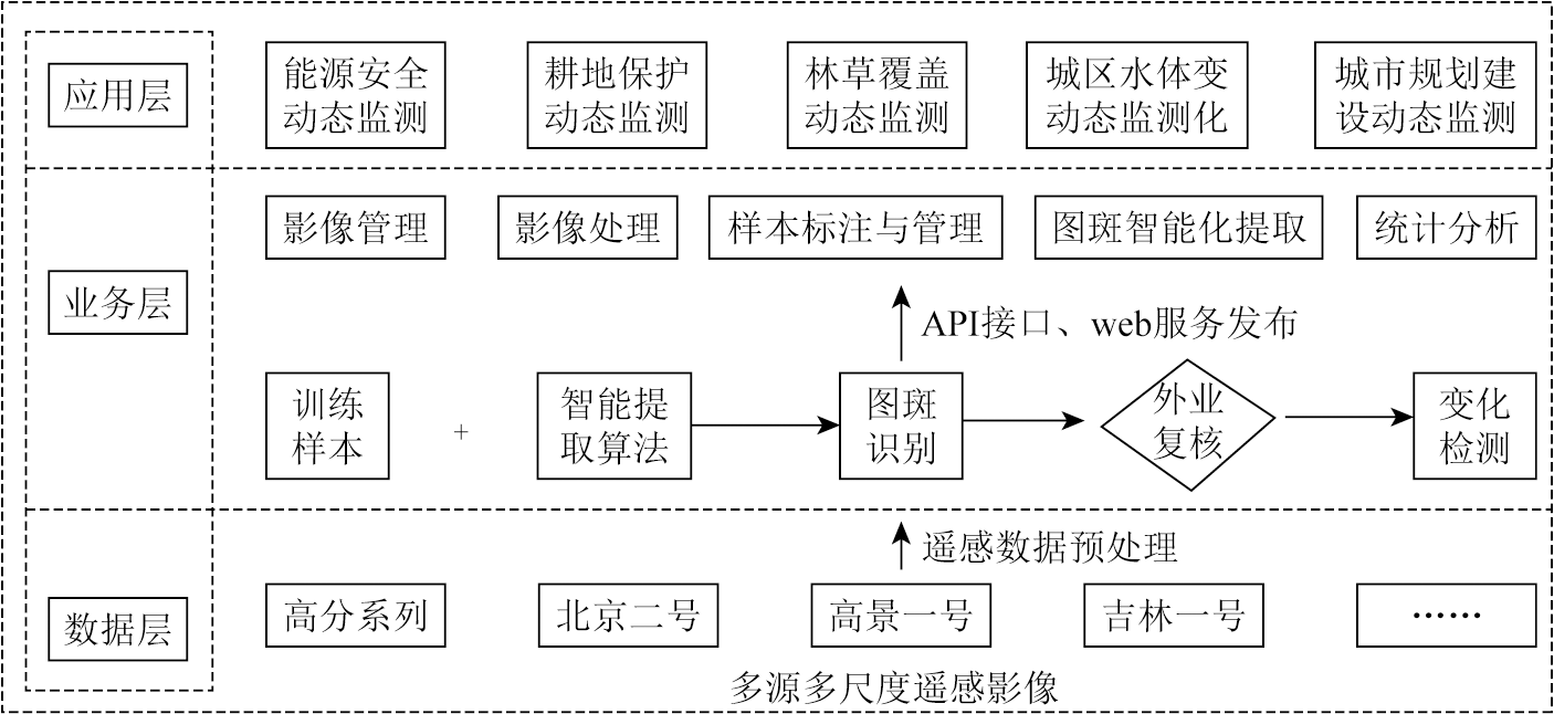
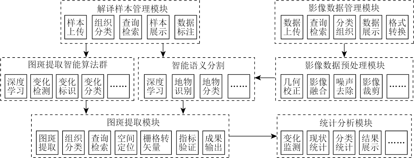
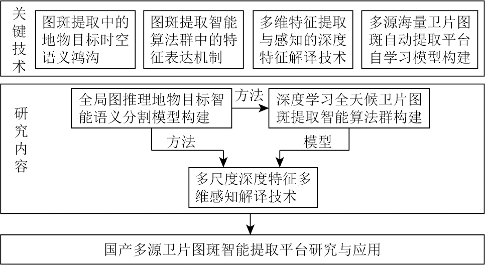
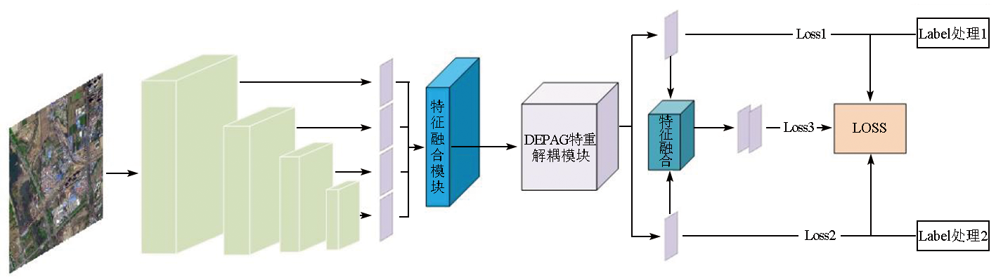
This study designed a one-stop platform for automatically extracting patches from multisource domestic satellite images based on a deep learning framework. The platform focuses primarily on critical techniques including semantic segmentation of ground objects, swarm intelligence algorithms for patch extraction, and deep feature interpretation. To address challenges in remote sensing image interpretation, such as significant color differences, vast data volumes of single images, diverse multi-channel image representations, and considerable differences in the sizes of remote sensing targets, the platform incorporates intelligent semantic segmentation and swarm intelligence algorithms for automatic patch extraction into the framework. It offers a range of customizable general and specialized models while supporting the self-training of models. With functions including large-scale data management, data annotation, model training, model testing, patch extraction, and application analysis, the platform has been successfully applied to the intelligent semantic segmentation and patch extraction of ground objects like buildings, vegetation, farmland, industrial zones, and water bodies in Taiyuan City, Shanxi Province based on multisource domestic satellite images.
PANG Min . An intelligent platform for extracting patches from multisource domestic satellite images and its application[J]. Remote Sensing for Natural Resources, 2025 , 37(2) : 148 -154 . DOI: 10.6046/zrzyyg.2024054
表1 整合后分类图斑统计表Tab.1 Integrated classification spot statistics (个) |
| 年度 | 耕地 | 林地 | 草地 | 水体 | 建筑物 | 硬化 地表 | 堆掘地 |
|---|---|---|---|---|---|---|---|
| 2015年 | 9 034 | 32 877 | 19 926 | 1 639 | 18 764 | 6 479 | 2 916 |
| 2016年 | 9 074 | 32 792 | 19 912 | 1 583 | 18 734 | 6 760 | 2 877 |
| 2017年 | 8 897 | 32 723 | 19 373 | 1 520 | 19 761 | 12 913 | 3 201 |
| 2018年 | 8 798 | 32 679 | 18 851 | 1 507 | 20 792 | 13 496 | 3 784 |
| 2019年 | 9 558 | 35 806 | 19 207 | 1 579 | 22 065 | 15 287 | 5 223 |
| 2020年 | 9 513 | 43 966 | 20 027 | 2 780 | 23 580 | 16 112 | 5 616 |
| 2021年 | 23 671 | 75 282 | 36 972 | 2 520 | 20 082 | 26 896 | 23 527 |
表2 各模型算法在2019年太原遥感影像数据集试验指标Tab.2 Experimental indicators of various model algorithms on the 2019 Taiyuan remote sensing image dataset (%) |
| 方法 | Acc | 总体指标 | ||||||||
|---|---|---|---|---|---|---|---|---|---|---|
| 耕地 | 草地 | 水体 | 建筑物 | 硬化地表 | 堆掘地 | 道路 | mAcc | mIoU | mF1 | |
| PSPNet | 79.94 | 44.35 | 88.09 | 86.76 | 26.67 | 69.10 | 69.23 | 69.62 | 57.33 | 70.61 |
| DeepLabV3 | 77.68 | 44.19 | 87.08 | 86.39 | 29.21 | 70.04 | 68.49 | 69.58 | 56.68 | 69.78 |
| Segformer | 82.46 | 51.64 | 87.69 | 85.77 | 26.47 | 71.65 | 70.97 | 71.07 | 58.92 | 71.69 |
| Swin Transformer | 82.93 | 37.99 | 87.01 | 88.36 | 11.09 | 71.60 | 61.42 | 67.09 | 55.59 | 68.34 |
| DeepLabv3+Res2Net | — | — | — | — | — | — | — | — | 59.97 | 72.92 |
| FTUnetFormer | 81.35 | 52.71 | 89.33 | 77.61 | — | 73.02 | 73.14 | 76.15 | 64.30 | 78.76 |
| [1] |
刘东升, 廖通逵, 孙焕英, 等. 中国遥感软件研制进展与发展方向——以像素专家PIE为例[J]. 中国图象图形学报, 2021, 26(5):1169-1178.
|
| [2] |
胥培雲, 谢春营, 邹健健. 基于U-Net的高分辨率遥感影像建筑物自动解译[J]. 国土资源导刊, 2023, 20(2):66-71.
|
| [3] |
郭恒亮, 牛子儒, 赫晓慧, 等. 基于多尺度特征融合的遥感影像语义分割[J]. 计算机应用与软件, 2023, 40(11):248-253.
|
| [4] |
|
| [5] |
|
| [6] |
崔宾阁, 吴景, 李心慧, 等. 结合深度学习和植被指数的滨海湿地高分二号遥感影像信息提取[J]. 遥感学报, 2023, 27(6):1376-1386.
|
| [7] |
李笑迎. 高分辨率遥感图像语义分割网络模型研究[D]. 秦皇岛: 燕山大学, 2022.
|
| [8] |
|
| [9] |
程滔, 吴芸, 郑新燕, 等. 面向遥感影像智能分类的海量样本数据采集方法[J]. 测绘通报, 2019(10):56-60.
|
| [10] |
|
| [11] |
|
| [12] |
|
| [13] |
张戬, 高雅. 深度学习遥感影像解译技术在耕地保护中的应用[J]. 测绘通报, 2023(8):142-145.
|
| [14] |
赵凌虎, 袁希平, 甘淑, 等. 改进Deeplabv3+的高分辨率遥感影像道路提取模型[J]. 自然资源遥感, 2023, 35(1):107-114.doi: 10.6046/zrzyyg.2021460.
|
| [15] |
凤磊, 陆灏, 耿帅帅, 等. 基于改进Deeplabv3+的遥感图像语义分割算法[J]. 宁夏师范学院学报, 2023, 44(10):65-74.
|
| [16] |
戴永东, 姚建光, 李勇, 等. 输电线路无人机巡检自主导航算法研究[J]. 重庆理工大学学报(自然科学), 2023, 37(11):221-228.
|
/
| 〈 |
|
〉 |