
Remote Sensing for Natural Resources >
Application of remote sensing geology in mineral prospecting in the Ke’eryin rare metal ore concentration area in the western Sichuan Basin
Received date: 2023-11-06
Revised date: 2024-03-30
Online published: 2026-06-03
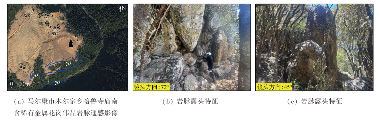
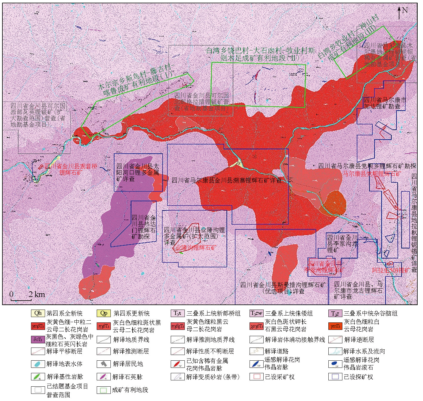
The Ke’eryin rare metal ore concentration area in the western Sichuan Basin (also referred to as the Ke’eryin ore concentration area), located in the eastern segment of the Songpan-Ganzi metallogenic belt, boasts abundant granitic pegmatite-hosted rare metal resources like lithium, niobium, beryllium, and tantalum. It stands as one of the most concentrated areas for hard-rock rare metal deposits in China, following the granitic pegmatite-type rare metal ore concentration areas in the Koktokay area in Altay in Xinjiang, and the Jiajika and Jiulong areas in the western Sichuan Basin. The Ke’eryin ore concentration area is characterized by tectonic denudation and deeply cut high mountains, resulting in inconvenient transportation, dense vegetation, and steep terrains. Consequently, most parts of the area are inaccessible to humans, hindering the implementation of traditional geological surveys. Based on the features and interpretation keys of high-resolution remote sensing images for ore-bearing granitic pegmatite veins in known deposits within the Ke’eryin ore concentration area, this study performed laboratory interpretation and partial field verification of these veins, revealing the distribution patterns and characteristics of granitic pegmatite veins in the area. Rare metal deposits hosted by granitic pegmatite veins intruded into weak structures such as fault zones and surrounding rock fractures within a range of 0 km to 5 km on the margin of the Ke’eryin complex rock mass. The exposed granitic pegmatite veins and boulders were identified as the most direct indicators for locating rare metal deposits. A prospecting method based on remote sensing geology was developed for highly vegetation-covered areas in the Ke’eryin ore concentration area, effectively addressing the limitations of traditional geological prospecting methods. Using the developed method, this study determined three critical prospecting areas in the northern and northwestern portions of the Ke’eryin complex rock mass, establishing them as the targets for subsequent strategic prospecting breakthroughs.
SHI Junbo , ZHANG Jie , HOU Na , ZHANG Huishan , DING Xiaoping , DU Jianjun , ZHU Haiyang . Application of remote sensing geology in mineral prospecting in the Ke’eryin rare metal ore concentration area in the western Sichuan Basin[J]. Remote Sensing for Natural Resources, 2025 , 37(2) : 117 -127 . DOI: 10.6046/zrzyyg.2023336
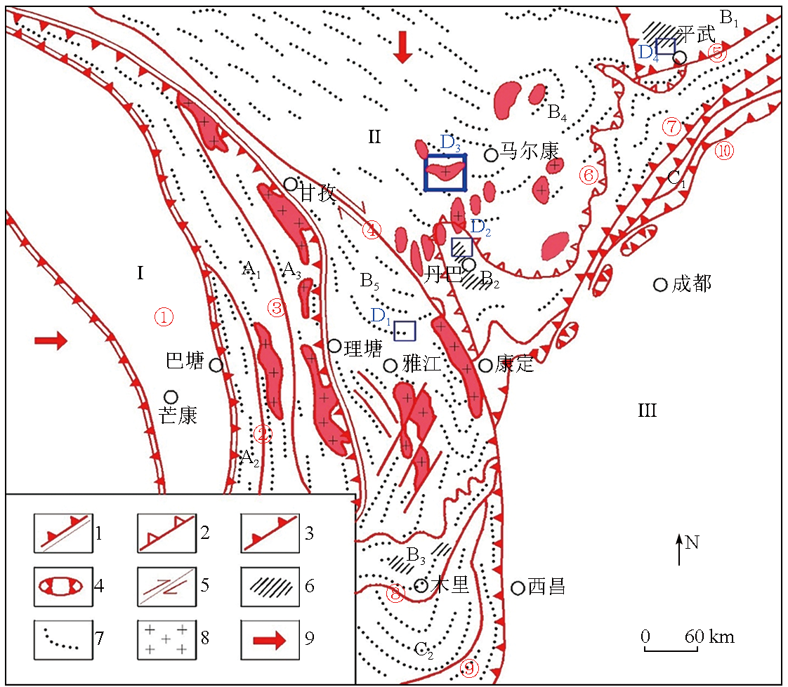
图1 松潘—甘孜造山带构造图(据参考文献[13]修编)1.蛇绿混杂岩带; 2.滑脱带; 3.逆冲断层; 4.飞来峰; 5.平移断层; 6.深层高温韧性滑脱剪切带出露范围; 7.褶皱轴线; 8.中生代花岗岩; 9.韧性滑移矢量; Ⅰ.羌塘—昌都陆块; Ⅱ.松潘—甘孜造山带; Ⅲ.扬子陆块; A1.中咱微板块; A2.白玉—义敦弧前(间)带; A3.沙鲁里主弧逆冲断带; B1.摩天岭逆冲滑脱推覆带; B2.马尔康北东陆源中央褶皱推覆带; B3.汶川—丹巴腹地弧形滑脱推覆带; B4.雅江被动陆源中央褶皱带推覆带; B5.木里腹陆弧形滑脱推覆带; C1.龙门山前陆逆冲带; C2.盐源前陆逆冲带; D1.甲基卡伟晶岩型稀有金属矿集区; D2.丹巴伟晶岩型白云母矿集区; D3.可尔因伟晶岩型稀有金属矿集区; D4.雪宝顶伟晶岩型稀有金属矿集区; ①金沙江蛇绿混杂岩带; ②定曲—盖玉逆冲断层; ③甘孜—理塘蛇绿混杂岩带; ④鲜水河平移剪切带; ⑤青川逆冲带; ⑥丹巴北缘滑脱带; ⑦龙门山断裂带; ⑧木里断裂带; ⑨北川—映秀断裂带; ⑩金河—箐河断裂带 Fig.1 Structural map of the Songpan-Ganzi orogenic belt(revised according to reference[13]) |
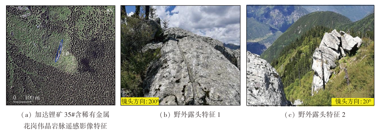
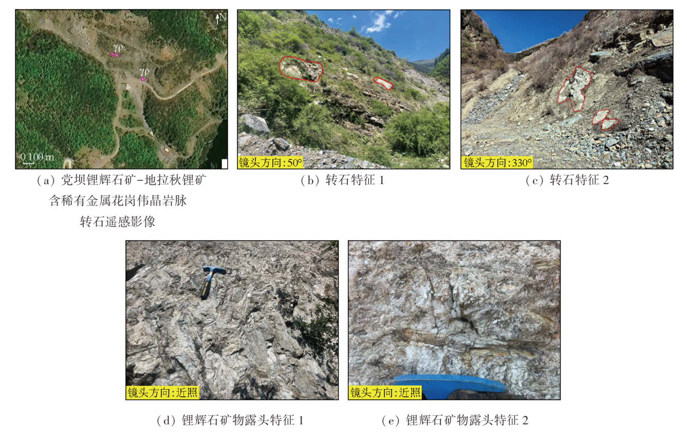
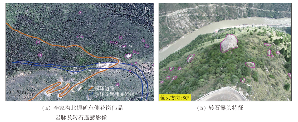
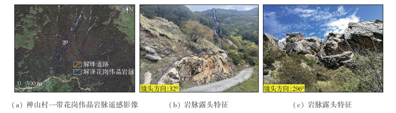
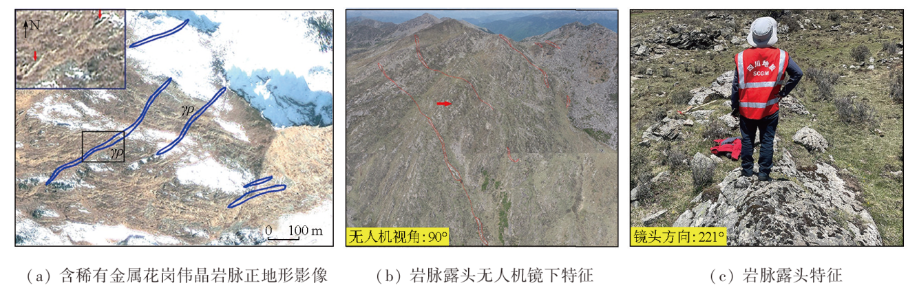
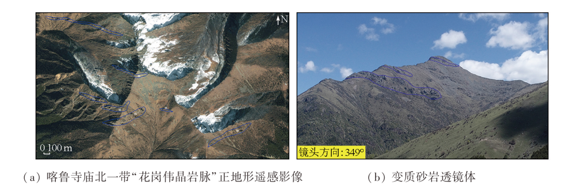
表1 花岗伟晶岩脉及其转石遥感解译标志表Tab.1 The remote sensing interpretation keys of granitic pegmative veins and its rolling rocks |
| 解译对象 | 矿物成分特征 | 地形地貌特征 | 遥感解译标志 |
|---|---|---|---|
| 花岗伟晶岩脉 | 主要矿物成分常有微斜长石、钠长石、石英、锂辉石、锂云母、白云母、黑云母及少量其他暗色矿物 | 正地形凸起或陡崖 | 灰色、灰白色,呈高亮度的狭窄条带状、透镜状影纹 |
| 花岗伟晶岩转石 | 散落或堆积在有花岗伟晶岩脉出露的坡体下方 | 灰色、灰白色,呈高亮度的团块状(块石),常掩盖于密林之中 |
| [1] |
李建康. 川西典型伟晶岩型矿床的形成机理及其大陆动力学背景[D]. 北京: 中国地质大学(北京), 2006.
|
| [2] |
岳相元, 张贻, 周雄, 等. 川西可尔因矿集区稀有金属矿床成矿规律与找矿方向[J]. 矿床地质, 2019, 38(4):867-876.
|
| [3] |
王子平, 刘善宝, 马圣钞, 等. 四川阿坝州党坝超大型锂辉石矿床成矿规律及深部和外围找矿方向[J]. 地球科学, 2018, 43(6):2029-2041.
|
| [4] |
郑艺龙, 许志琴, 高文琦, 等. 川西马尔康片麻岩穹隆与伟晶岩型锂矿的构造成因[J]. 地质学报, 2021, 95(10):3069-3084.
|
| [5] |
王登红, 刘丽君, 侯江龙, 等. 初论甲基卡式稀有金属矿床“五层楼+地下室”勘查模型[J]. 地学前缘, 2017, 24(5):1-7.
|
| [6] |
刘善宝, 王成辉, 王登红, 等. 四川甲基卡锂矿伟晶岩转石分布区“3定2参”大比例尺填图法及其在青藏高原应用的意义[J]. 地质学报, 2020, 94(1):326-332.
|
| [7] |
|
| [8] |
|
| [9] |
范玉海, 王辉, 杨兴科, 等. 基于高分辨率遥感数据的稀有金属矿化带勘查[J]. 国土资源遥感, 2018, 30(1):128-134.doi:10.6046/gtzyyg.2018.01.18.
|
| [10] |
张微, 金谋顺, 张少鹏, 等. 高分遥感卫星数据在东昆仑成矿带找矿预测中的应用[J]. 国土资源遥感, 2016, 28(2):112-119.doi:10.6046/gtzyyg.2016.02.18.
|
| [11] |
姜琪, 代晶晶, 王登红, 等. 光学遥感在识别花岗伟晶岩型锂矿床中的应用[J]. 矿床地质, 2021, 40(4):793-804.
|
| [12] |
潘桂堂, 肖庆辉. 中国大地构造图(1∶2500000)[M]. 北京: 地质出版社, 2015.
|
| [13] |
许志琴, 侯立玮, 王宗秀. 中国松潘-甘孜造山带的造山过程[M]. 北京: 地质出版社, 1992.
|
| [14] |
许志琴, 王汝成, 赵中宝, 等. 试论中国大陆“硬岩型”大型锂矿带的构造背景[J]. 地质学报, 2018, 92(6):1091-1106.
|
| [15] |
|
| [16] |
|
| [17] |
时章亮, 张宏飞, 蔡宏明. 松潘造山带马尔康强过铝质花岗岩的成因及其构造意义[J]. 地球科学, 2009, 34(4):569-584.
|
| [18] |
张伟, 邹林, 范映武, 等. 四川金川县热达门锂辉石矿地质特征及矿床成矿模型浅析[J]. 四川地质学报, 2019, 39(s1):55-59.
|
| [19] |
李建康, 王登红, 付小方. 川西可尔因伟晶岩型稀有金属矿床的40Ar/39Ar年代及其构造意义[J]. 地质学报, 2006, 80(6):843-848.
|
| [20] |
古城会. 四川省可尔因伟晶岩田东南密集区锂辉石矿床成矿规律[J]. 地质找矿论丛, 2014, 29(1):59-65.
|
| [21] |
庞博, 古城会, 李良波, 等. 四川省马尔康党坝锂辉石矿床地质特征及成因研究[J]. 四川有色金属, 2015(4):31-34.
|
| [22] |
景明, 邓涛. 马尔康白湾锂矿区地质特征及找矿标志[J]. 四川地质学报, 2016, 36(2):280-283.
|
| [23] |
饶魁元. 四川马尔康地拉秋锂矿床地质特征及找矿方向[J]. 四川有色金属, 2016 (1):54-57.
|
| [24] |
马圣钞, 王登红, 刘善宝, 等. 川西可尔因锂矿田云母矿物化学及稀有金属成矿和找矿指示[J]. 矿床地质, 2019, 38(4):877-897.
|
| [25] |
费光春, 方兵. 川西可尔因矿田李家沟锂辉石矿床矿石组构特征[J]. 矿物学报, 2015, 35(s1):1000.
|
/
| 〈 |
|
〉 |