
Remote Sensing for Natural Resources >
Grassland degradation and its response to drought in the western Songnen Plain based on comprehensive remote sensing index
Received date: 2023-08-02
Revised date: 2023-11-21
Online published: 2026-06-03
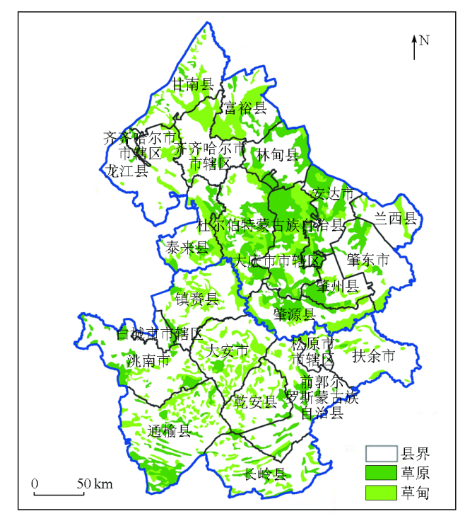
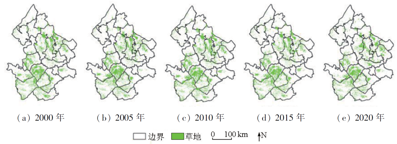
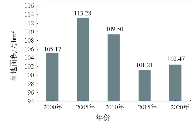
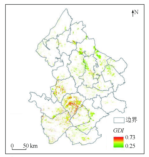
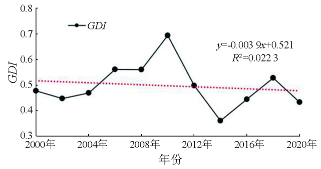
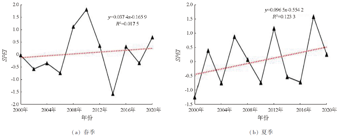
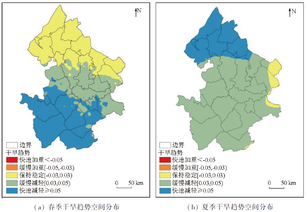
The grassland ecosystem is one of the most important and widely distributed terrestrial ecosystems. Analyzing the grassland degradation and its influential factors holds great significance for guiding the conservation and sustainable use of grassland resources, as well as the restoration and reconstruction of degraded ecosystems. This study extracted information on the distribution of grassland in western Songnen Plain using an object-oriented classification method and a multi-layer decision tree while comprehensively considering the degradation of vegetation and soils. Using Landsat TM image data, this study constructed a comprehensive grassland degradation index (GDI) for 11 even years from 2000 to 2020, followed by the assessment of the spatiotemporal dynamics of grassland degradation. Using the standardized precipitation evapotranspiration index (SPEI) as an indicator of drought, this study analyzed the responses of grassland degradation to the spatiotemporal changes in climate-induced drought. The results indicate that from 2000 to 2020, grassland in the western Songnen Plain decreased to 1 024 700 hm2 from 1 051 700 hm2, with an annual decreasing rate of 0.1%. The grassland degradation showed a nonsignificant downward trend, with 81.7% of the grassland exhibiting a stable or downward degradation trend. The SPEI exhibited an increasing trend in both spring and summer, representing a downward drought trend with significant regional differences. Besides, there was a nonsignificant weak positive correlation between GDI and SPEI in both spring and summer. The results of this study will provide data support for the conservation and sustainable use of grasslands in the western Songnen Plain, while also holding active significance for managing and controlling the ecological and economic benefits of grasslands in this region.
LIU Wenhui , LI Xinye , LI Xiaoyan . Grassland degradation and its response to drought in the western Songnen Plain based on comprehensive remote sensing index[J]. Remote Sensing for Natural Resources, 2025 , 37(1) : 232 -242 . DOI: 10.6046/zrzyyg.2023235
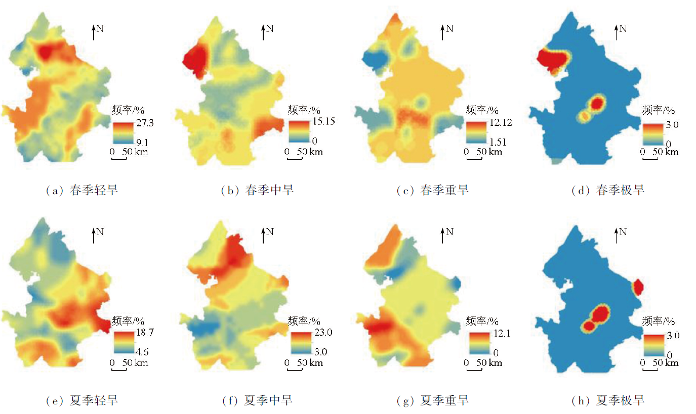
表1 基于SPEI指数的干旱分级Tab.1 Drought classification based on SPEI |
| SPEI | >-0.5 | (-1,-0.5] | (-1.5,-1] | (-2,-1.5) | ≤-2 |
|---|---|---|---|---|---|
| 分级 | 无旱 | 轻度干旱 | 中度干旱 | 重度干旱 | 极度干旱 |
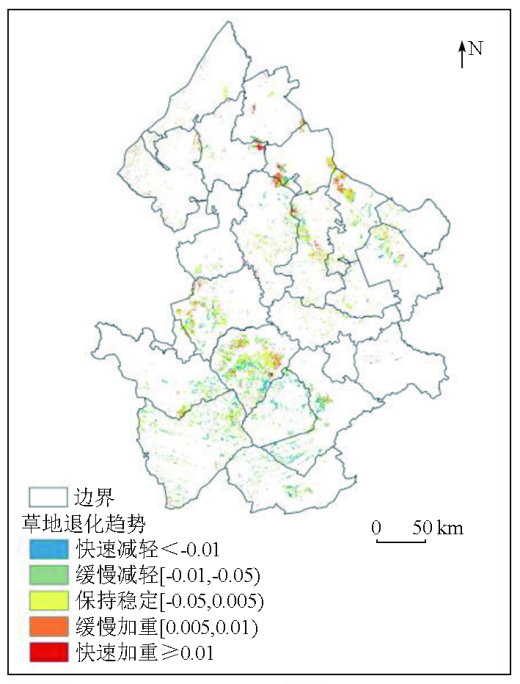
表2 草地退化趋势各级别面积及占比Tab.2 Area and proportion of grassland degradation trend for each level |
| 草地退化趋势 | 面积/hm2 | 占比/% |
|---|---|---|
| 快速减轻 | 146 514.90 | 23.40 |
| 缓慢减轻 | 104 126.90 | 16.60 |
| 保持稳定 | 260 866.10 | 41.66 |
| 缓慢加重 | 72 053.55 | 11.50 |
| 快速加重 | 42 453.63 | 6.78 |
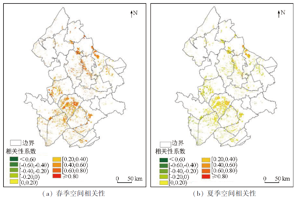
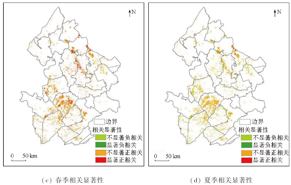
图10-1 2000—2020年松嫩平原西部GDI与春、夏SPEI指数空间相关性和相关显著性空间分布Fig.10-1 Spatial correlation and correlation significance of GDI and SPEI in spring and summer in western Songnen Plain during 2000—2020 |
图10-2 2000—2020年松嫩平原西部GDI与春、夏SPEI指数空间相关性和相关显著性空间分布Fig.10-2 Spatial correlation and correlation significance of GDI and SPEI in spring and summer in western Songnen Plain during 2000—2020 |
表3 GDI与春、夏季SPEI相关显著类型面积统计Tab.3 Ratio of correlation significance for SPEI and GDI in spring and summer |
| 季节 | 不显著负相关 (p>0.05) | 显著负相关 (p<0.05) | 不显著正相关 (p>0.05) | 显著正相关 (p<0.05) |
|---|---|---|---|---|
| 春季 | 3.4 | 0.8 | 59.5 | 36.3 |
| 夏季 | 31.0 | 0.1 | 67.7 | 1.2 |
表4 不同草地类型GDI与春、夏季SPEI趋势变化相关系数Tab.4 Correlation between GDI and SPEI for steppe and meadow in spring and summer |
| 相关分析 | 春季SPEI | 夏季SPEI | 样本数 |
|---|---|---|---|
| 草原GDI | -0.265**① | 0.243** | 5 402 |
| 草甸GDI | -0.374** | 0.296** | 5 016 |
①**表示p<0.01(相关系数在0.01水平上显著)。 |
| [1] |
|
| [2] |
|
| [3] |
|
| [4] |
|
| [5] |
王合云, 郭建英, 李红丽, 等. 短花针茅荒漠草原不同退化程度的植被特征[J]. 中国草地学报, 2015, 37(3):74-79.
|
| [6] |
秦金萍, 刘颖, 马玉寿, 等. 返青期休牧对退化高寒草甸植被生长及其优势植物垂穗披碱草光合作用的影响[J]. 草地学报, 2020, 28(4):1068-1075.
|
| [7] |
刘晓光. 阴山北麓草原植被不同退化程度特征分析[J]. 内蒙古农业大学学报(自然科学版), 2015, 36(6):65-69.
|
| [8] |
罗玲, 王宗明, 毛德华, 等. 松嫩平原西部草地净初级生产力对气候变化及人类活动的响应[J]. 生态学杂志, 2012, 31(6):1533-1540.
|
| [9] |
|
| [10] |
薛鹏飞. 高寒草地退化遥感监测与综合评价——以甘南地区为例[D]. 兰州: 兰州大学, 2022.
|
| [11] |
陈曦. 中国干旱区自然地理[M]. 北京: 科学出版社,2010:7-9.
|
| [12] |
乌尼图, 刘桂香, 杨勇, 等. 基于光能利用率模型的内蒙古天然草原植被净初级生产力动态监测与气候因子的响应[J]. 草业学报, 2020, 29(11):1-10.
|
| [13] |
|
| [14] |
郭嘉豪, 王会肖, 赵茹欣, 等. 基于多维Copula函数的松嫩平原干旱特征分析[J]. 节水灌溉, 2020(12):57-63,67.
|
| [15] |
杨帆, 黄庆阳, 谢立红, 等. 松嫩平原草原退化原因及其生态恢复方法[J]. 国土与自然资源研究, 2021(4):90-92.
|
| [16] |
李强. 不同恢复措施对松嫩平原退化草地的作用[D]. 长春: 东北师范大学, 2010.
|
| [17] |
|
| [18] |
|
| [19] |
武爽, 冯险峰, 孔玲玲, 等. 气候变化及人为干扰对西藏地区草地退化的影响研究[J]. 地理研究, 2021, 40(5):1265-1279.
|
| [20] |
|
| [21] |
|
| [22] |
江笑薇. 黄土高原地区干旱及土地利用变化对植被净初级生产力影响的量化研究[D]. 西安: 陕西师范大学, 2021.
|
| [23] |
张颖, 章超斌, 王钊齐, 等. 三江源1982—2012年草地植被覆盖度动态及其对气候变化的响应[J]. 草业科学, 2017, 34(10):1977-1990.
|
| [24] |
|
| [25] |
王静, 郭铌, 蔡迪花, 等. 玛曲县草地退牧还草工程效果评价[J]. 生态学报, 2009, 29(3):1276-1284.
|
| [26] |
石明明, 王喆, 周秉荣, 等. 青藏高原草地退化特征及其与气候因子的关系[J]. 应用生态学报, 2022, 33(12):3271-3278.
|
| [27] |
康振山, 张莎, 白雲, 等. 内蒙古草地净初级生产力时空变化及其对干旱的响应[J]. 草地学报, 2021, 29(1):156-165.
|
| [28] |
|
| [29] |
|
| [30] |
王浩男. 松嫩平原盐碱地景观格局演化及驱动力分析[D]. 长春: 吉林大学, 2021.
|
| [31] |
李叶. 松嫩平原盐碱地植被状况时空变化精细化模型构建[D]. 长春: 吉林大学, 2022.
|
| [32] |
满卫东, 刘明月, 王宗明, 等. 1990—2015年东北地区草地变化遥感监测研究[J]. 中国环境科学, 2020, 40(5):2246-2253.
|
| [33] |
牛书丽, 蒋高明. 人工草地在退化草地恢复中的作用及其研究现状[J]. 应用生态学报, 2004, 15(9):1662-1666.
|
| [34] |
张世喆, 朱秀芳, 刘婷婷, 等. 气候变化下中国不同植被区总初级生产力对干旱的响应[J]. 生态学报, 2022, 42(8):3429-3440.
|
| [35] |
|
| [36] |
曹旭娟. 青藏高原草地退化及其对气候变化的响应[D]. 北京: 中国农业科学院, 2017.
|
| [37] |
李传新. 基于遥感的锡林河流域草地退化及影响因素分析[D]. 北京: 中国地质大学(北京), 2016.
|
| [38] |
|
| [39] |
邹杰. 中亚地区生态系统水分利用效率时空分布及其干旱抗逆效应[D]. 乌鲁木齐: 新疆大学, 2020.
|
| [40] |
|
| [41] |
|
| [42] |
|
/
| 〈 |
|
〉 |