
Remote Sensing for Natural Resources >
Forest disturbance monitoring in Lishui City, China based on Landsat time series images and the LandTrendr algorithm
Received date: 2023-09-12
Revised date: 2024-03-01
Online published: 2026-06-03
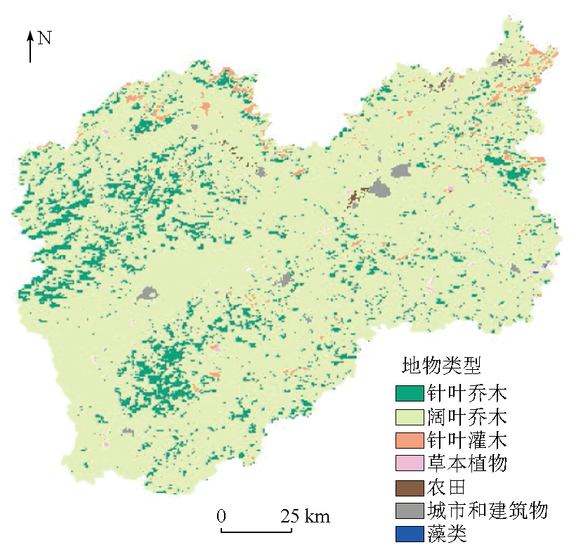
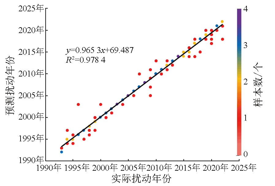
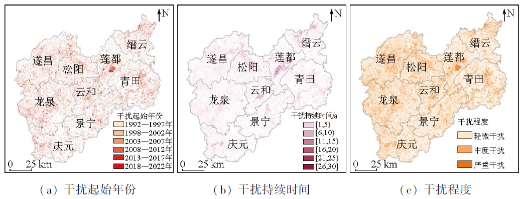
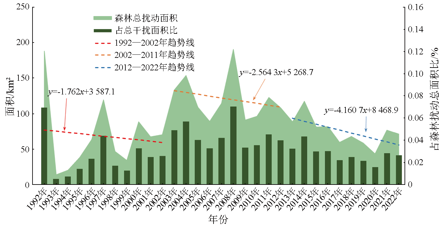
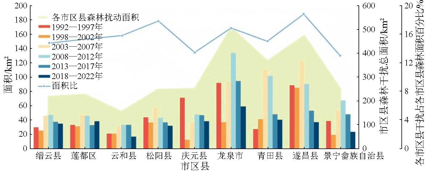
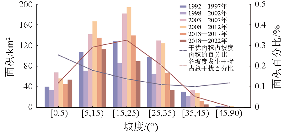
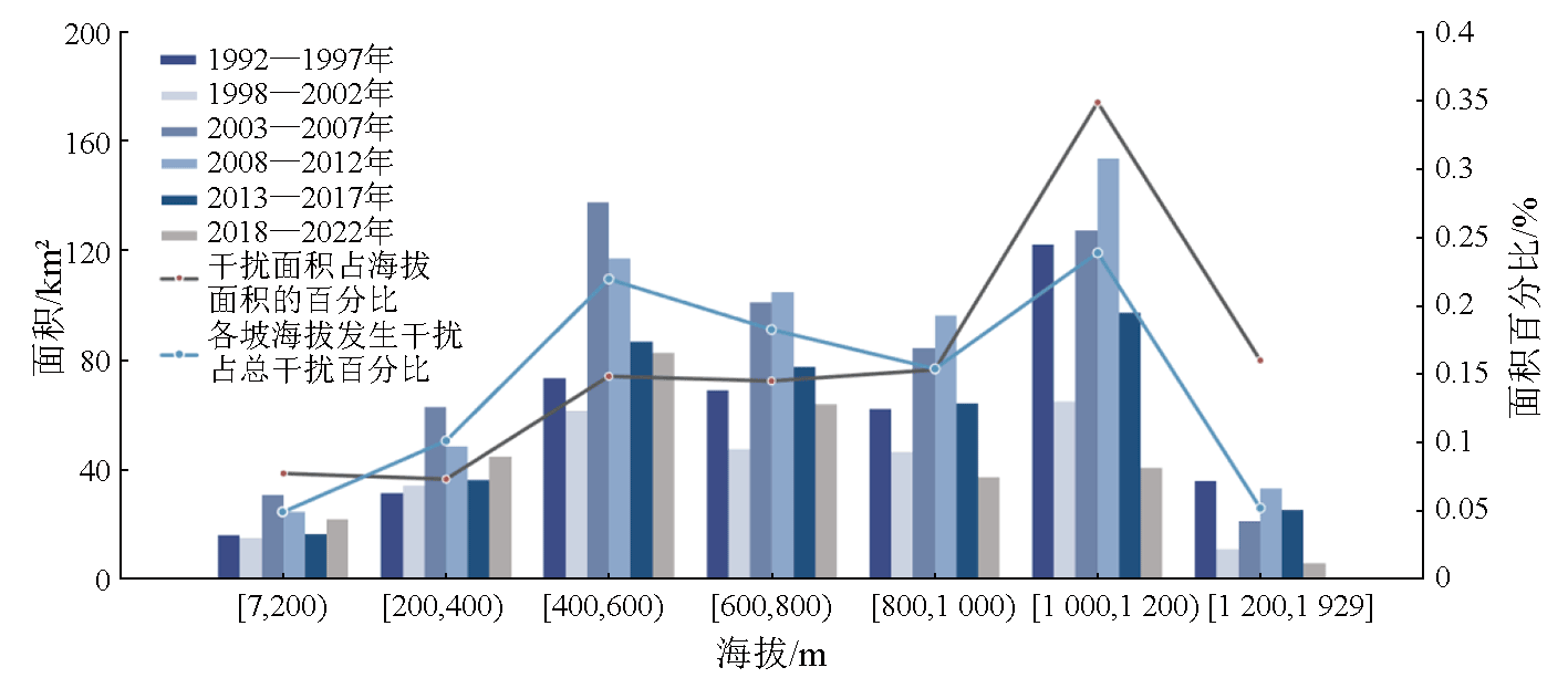
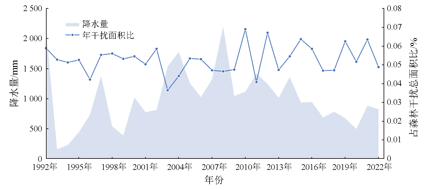
The rapid and accurate acquisition of forest disturbances using advanced technological methods is of great significance for maintaining forest ecological security. In this study, all Landsat images of Lishui City, China from June to August from 1992 to 2022 were acquired. Based on the LandTrendr algorithm on the Google Earth Engine (GEE) platform, this study analyzed the characteristics of forest disturbances in the city. A spatiotemporal analysis of forest disturbances across various counties and cities within Lishui was conducted, and the influence patterns of natural factors including slope, elevation, and precipitation on forest disturbances were also explored. The results indicate that vegetation disturbances in Lishui City generally decreased over the 30 years. Spatially, the most severe forest disturbances occurred in Longquan City and Suichang County located in northwestern Lishui City. Temporally, 2008 witnessed the most severe forest disturbances. In addition, areas with gentle slopes and high elevations, as well as years with reduced precipitation, were more sensitive to forest disturbance over the 30 years. This study will provide a scientific basis and reference for the preservation and management of forest resources in Lishui City.
Key words: time series; LandTrendr; Google Earth Engine (GEE); forest disturbance
CHEN Yuanyuan , YAN Shuoting , YAN Jin , ZHENG Siqi , WANG Hao , ZHU Jie . Forest disturbance monitoring in Lishui City, China based on Landsat time series images and the LandTrendr algorithm[J]. Remote Sensing for Natural Resources, 2025 , 37(1) : 179 -187 . DOI: 10.6046/zrzyyg.2023285
表1 LandTrendr参数Tab.1 LandTrendr parameter |
| 参数 | 参数含义 | 取值 |
|---|---|---|
| Max Segments | 分割最大单元数目 | 7 |
| Spike Threshold | 初始阶段拟合的折点数 | 0.9 |
| Vertex Count Overshoot | 可超过的顶点数量 | 3 |
| Prevent One Year Recovery | 是否阻止一年后恢复的情况 | True |
| Recovery Threshold | 恢复是否具有上升(正)趋势 | 0.5 |
| p-value Threshold | 回归分析中F检验的p值,超过该值的话,则认为该像元没有发生变化 | 0.05 |
| Best Model Proportion | 简单模型的选择规则,如果超过该值,则被选中 | 0.75 |
| Min Observations Needed | 拟合中需要的最少观测数 | 6 |
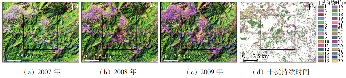
图2 LandTrendr干扰持续时间及2007—2009年样点区域目视解译Fig.2 LandTrendr interference duration and visual interpretation of sample areas from 2007 to 2009 |
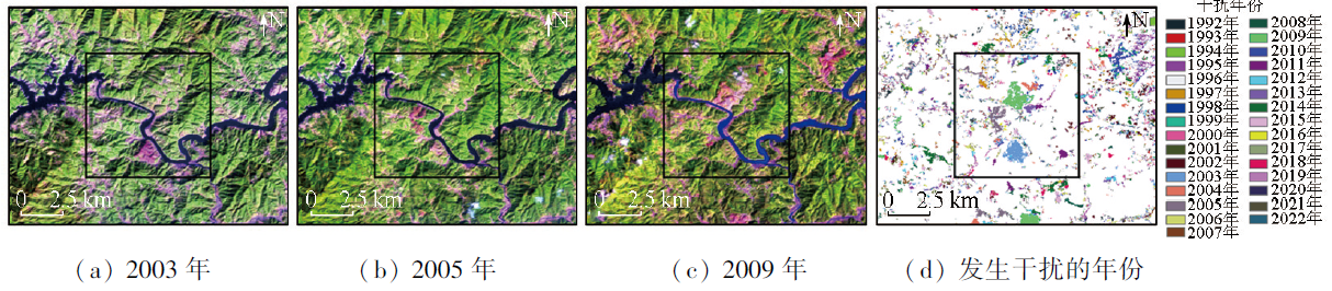
图3 LandTrendr发生干扰的年份及样点区域目视解译Fig.3 The year of LandTrendr interference and the visual interpretation of sample areas |
| [1] |
|
| [2] |
|
| [3] |
|
| [4] |
|
| [5] |
|
| [6] |
王燕, 朱婷茹, 何立恒. 森林资源遥感调查研究进展[J]. 现代测绘, 2022, 45(6):1-6,60.
|
| [7] |
王平. 南通市生态环境遥感监测及其动态变化研究[J]. 环境监控与预警, 2012, 4(6):42-45.
|
| [8] |
杨强, 王婷婷, 陈昊, 等. 基于MODIS EVI数据的锡林郭勒盟植被覆盖度变化特征[J]. 农业工程学报, 2015, 31(22):191-198,315.
|
| [9] |
钟莉, 陈芸芝, 汪小钦. 基于Landsat时序数据的森林干扰监测[J]. 林业科学, 2020, 56(5):80-88.
|
| [10] |
沈文娟, 李明诗, 黄成全. 长时间序列多源遥感数据的森林干扰监测算法研究进展[J]. 遥感学报, 2018, 22(6):1005-1022.
|
| [11] |
|
| [12] |
|
| [13] |
|
| [14] |
|
| [15] |
|
| [16] |
苏文瑞, 田佳, 杨泽康, 等. 基于GEE和LandTrendr的宁夏“三山” 森林干扰监测[J]. 中国水土保持科学(中英文), 2022, 20(6):41-49.
|
| [17] |
|
| [18] |
|
| [19] |
|
| [20] |
官王飞, 徐建恩, 叶珊, 等. 丽水市“十三五” 期间林木采伐现状分析[J]. 福建林业科技, 2022, 49(3):111-115,124.
|
| [21] |
|
| [22] |
王塞, 王思诗, 樊风雷. 基于时间序列分割算法的雅鲁藏布江流域NDVI(1985—2018)变化模式研究[J]. 生态学报,2020, 40(19):6863-6871.
|
| [23] |
于森, 贾明明, 陈高, 等. 基于LandTrendr算法海南东寨港红树林扰动研究[J]. 自然资源遥感, 2023, 35(2):42-49.doi:10.6046/zrzyyg.2022235.
|
| [24] |
|
| [25] |
|
| [26] |
|
| [27] |
殷崎栋, 柳彩霞, 田野. 基于Landsat时序影像和LandTrendr算法的森林保护区植被扰动研究——以陕西柴松和太白山保护区为例[J]. 生态学报, 2020, 40(20):7343-7352.
|
| [28] |
陈海喜, 钟九生, 兰安军, 等. 基于地形地貌因子的贵州省NDVI时空变化分析[J]. 贵州科学, 2019, 37(2):36-43.
|
| [29] |
维基百科编者. 丽水市[G/OL].维基百科,2024(20240201)[2024-02-01].https://zh.wikipedia.org/w/index.php?title=%E4%B8%BD%E6%B0%B4%E5%B8%82&o|did=80740233.
|
| [30] |
尹雄, 陈帮乾, 古晓威, 等. 基于GEE平台LandTrendr算法的海南岛森林扰动快速监测方法及分析[J]. 地球信息科学学报, 2023, 25(10):2093-2106.
|
/
| 〈 |
|
〉 |