
Remote Sensing for Natural Resources >
Information extraction of aquaculture ponds in the Jianghan Plain based on Sentinel-2 time-series data
Received date: 2023-09-14
Revised date: 2024-04-09
Online published: 2026-06-03
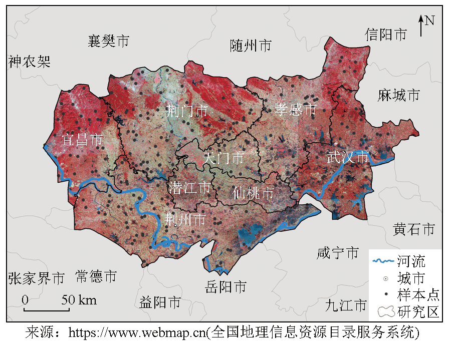
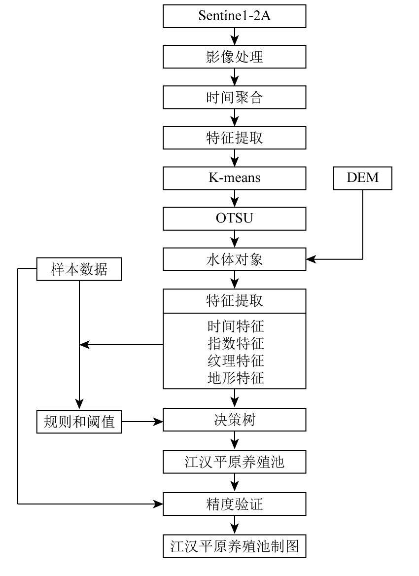
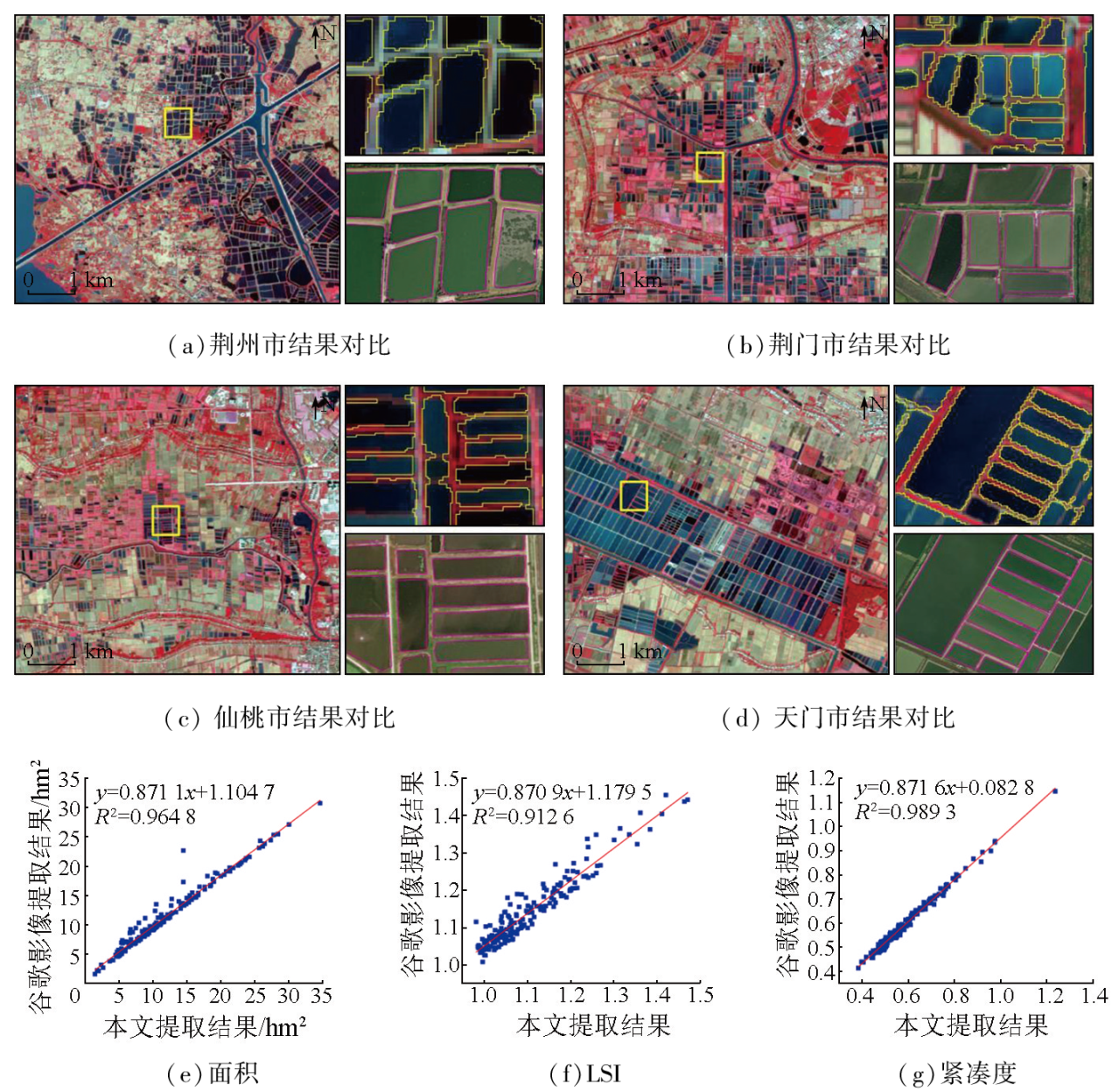
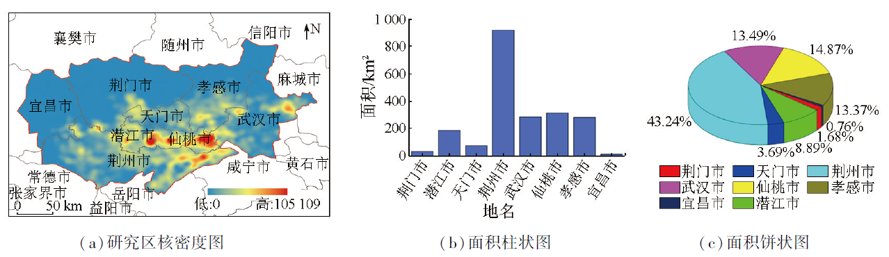
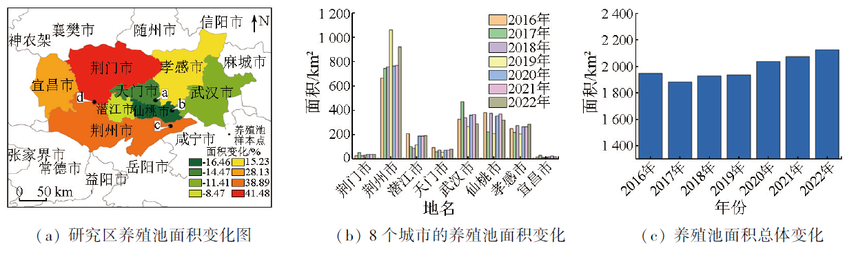
In recent years, the rapid expansion of the aquaculture pond industry has given rise to a series of ecological and environmental issues. The Jianghan Plain is recognized as one of the most important freshwater aquaculture bases in China, and investigating changes in its aquaculture ponds is crucial for China’s ecological conservation. Focusing on the Jianghan Plain, this study proposed a method for extracting and monitoring changes in aquaculture ponds using Google Earth Engine (GEE) and Sentinel-2 dense time-series images. Using this method, which combined K-means clustering and a hierarchical decision tree classification algorithm, this study achieved accurate information extraction and spatiotemporal pattern analyses of aquaculture ponds in the plain in each year from 2016 to 2022. The results indicate that the combination of K-means and the hierarchical decision tree algorithm that integrated time-varying features allowed for accurate classification of aquaculture ponds, with an overall classification accuracy of 91.90% and a Kappa coefficient exceeding 0.84. In 2022, the aquaculture pond area of Jianghan Plain is 2 126.43 km2. Among these area of aquaculture ponds, 43.24% were concentrated in Jingzhou City, while Yichang City had the fewest area of aquaculture ponds, accounting for only 0.76%. From 2016 to 2022, aquaculture ponds in the Jianghan Plain exhibited an upward trend overall and dynamics with pronounced spatial heterogeneity. Specifically, the total area increased to 2 126.43 km2 from 1 947.43 km2, increasing by 9.19%. The proposed methodology provides an important reference for the precise monitoring of aquaculture ponds, and the resulting dataset serves as a valuable reference and holds great practical significance for the ecological conservation and the assessment of sustainable development goals in the Jianghan Plain.
CHEN Zhiyang , MAO Dehua , WANG Zongming , LIN Nan , JIA Mingming , REN Chunying , WANG Ming . Information extraction of aquaculture ponds in the Jianghan Plain based on Sentinel-2 time-series data[J]. Remote Sensing for Natural Resources, 2025 , 37(1) : 169 -178 . DOI: 10.6046/zrzyyg.2023278
表1 2016—2020年研究区Sentinel-2卫星数据量Tab.1 Available Sentinel-2 image numbers for the study area from 2016 to 2022 |
| 年份 | 可用影像数/景 | 年份 | 可用影像数/景 | |
|---|---|---|---|---|
| 2016年 | 275 | 2020年 | 473 | |
| 2017年 | 299 | 2021年 | 553 | |
| 2018年 | 477 | 2022年 | 486 | |
| 2019年 | 495 | |||
表2 本研究所采用水体分类系统Tab.2 Water body classification system in the study area |
| 名称 | 描述 | 影像图 | 实地照片示例 |
|---|---|---|---|
| 养殖池 | 用于水产养殖的多边形水体,形状规则,靠近河流 | 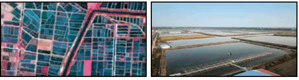 | |
| 湖泊 | 内陆地区有积水的自然多边形水体 | 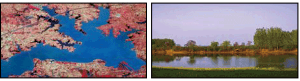 | |
| 河流 | 在内陆地区有流动水的自然线性水体 | 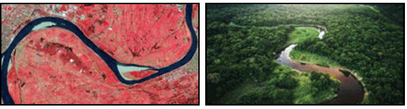 | |
| 水库/ 坑塘 | 有积水的人工多边形水体,一般有明显的水坝 | 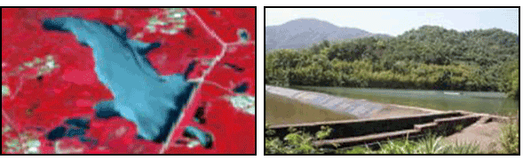 | |
| 水田 | 能种植水稻、冬季蓄水或浸湿状的农田 | 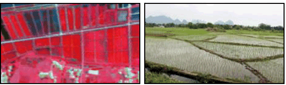 | |
表3 本研究所构建的2016—2022年样本数量Tab.3 Number of samples constructed in this study from 2016 to 2022 |
| 年份 | 养殖池样 本数量/个 | 非养殖池 样本数量/个 |
|---|---|---|
| 2016年 | 451 | 549 |
| 2017年 | 463 | 537 |
| 2018年 | 455 | 545 |
| 2019年 | 459 | 541 |
| 2020年 | 466 | 534 |
| 2021年 | 432 | 538 |
| 2022年 | 461 | 539 |
表4 本研究中所使用的3种形状度量的描述和公式Tab.4 Descriptions and formulas for the three shape metrics used in this study |
| 名称 | 介绍 | 公式 |
|---|---|---|
| LSI | 描述物体形状的曲率 | |
| 紧凑度(C) | 描述物体形状的曲率和紧凑度 | /4π |
| 矩形度(R) | 反映一个对象填充其外部矩形的程度 |
表5 混淆矩阵及精度分析Tab.5 Confusion matrix and classification accuracy analysis |
| 年份 | 类别 | 养殖池 | 非养 殖池 | Kappa 系数 | UA/% | PA/% | OA/% |
|---|---|---|---|---|---|---|---|
| 2016年 | 养殖池 非养殖池 | 402 49 | 52 497 | 0.84 | 93.37 | 90.20 | 91.90 |
| 2017年 | 养殖池 非养殖池 | 426 37 | 39 498 | 0.87 | 94.11 | 92.60 | 93.40 |
| 2018年 | 养殖池 非养殖池 | 410 45 | 41 504 | 0.85 | 93.62 | 91.00 | 92.40 |
| 2019年 | 养殖池 非养殖池 | 418 41 | 55 486 | 0.85 | 92.91 | 91.80 | 92.40 |
| 2020年 | 养殖池 非养殖池 | 432 34 | 47 487 | 0.88 | 94.52 | 93.20 | 93.90 |
| 2021年 | 养殖池 非养殖池 | 424 38 | 38 500 | 0.86 | 93.90 | 92.40 | 93.20 |
| 2022年 | 养殖池 非养殖池 | 422 39 | 41 498 | 0.88 | 95.25 | 92.20 | 93.80 |
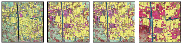
图9 2016—2022年江汉平原水产养殖池的空间变化Fig.9 Spatial distributions and areal changes of aquaculture ponds in study area from 2016 to 2022 |
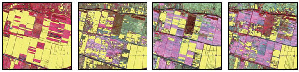
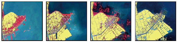
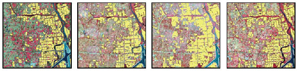
表7 本文数据集与3种全球10 m分辨率土地覆盖数据集对比Tab.7 Comparison of aquaculture ponds between datasets in this study and three global 10-m resolution land cover datasets |
| 提取结果 | 仙桃市 | 荆州市 | 孝感市 | 图例 |
|---|---|---|---|---|
| 样本范围 | 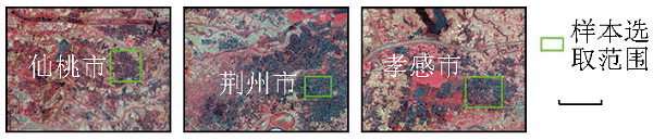 | |||
| 本文结果 | 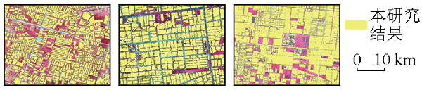 | |||
| ESA_ Worldcover | 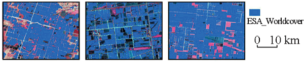 | |||
| FROM- GLC10 | 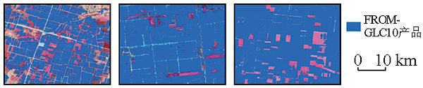 | |||
| Dynamic World | 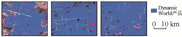 | |||
| [1] |
|
| [2] |
|
| [3] |
|
| [4] |
|
| [5] |
|
| [6] |
|
| [7] |
|
| [8] |
|
| [9] |
|
| [10] |
万敏, 刘梦馨, 黄婧, 等. 城市八景中的生态智慧考析——以江汉平原为例[J]. 中国园林, 2022, 38(7):18-25.
|
| [11] |
|
| [12] |
|
| [13] |
|
| [14] |
|
| [15] |
|
| [16] |
|
| [17] |
汪恩良, 徐雷, 韩红卫, 等. 基于OTSU算法提取寒区河流流冰密度研究[J]. 应用基础与工程科学学报, 2021, 29(6):1429-1439.
|
| [18] |
|
| [19] |
|
| [20] |
|
| [21] |
|
| [22] |
|
| [23] |
林丹. 基于小波变换的K-means算法在遥感图像分类中的应用研究[D]. 邯郸: 河北工程大学, 2015.
|
| [24] |
贾凯, 陈水森, 蒋卫国. 粤港澳大湾区红树林长时间序列遥感监测[J]. 遥感学报, 2022, 26(6):1096-1111.
|
/
| 〈 |
|
〉 |