
Remote Sensing for Natural Resources >
Application of Sentinel-1/2 imagery in identifying hills cutting and land reclaiming in the Beishan Mountain of Lanzhou
Received date: 2023-09-14
Revised date: 2023-12-19
Online published: 2026-06-03
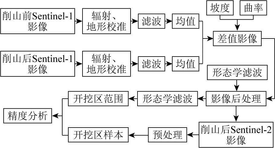
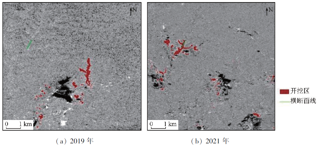
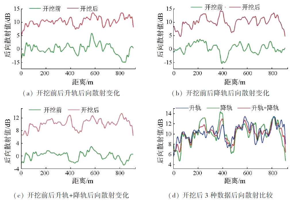
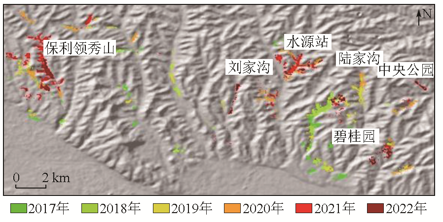
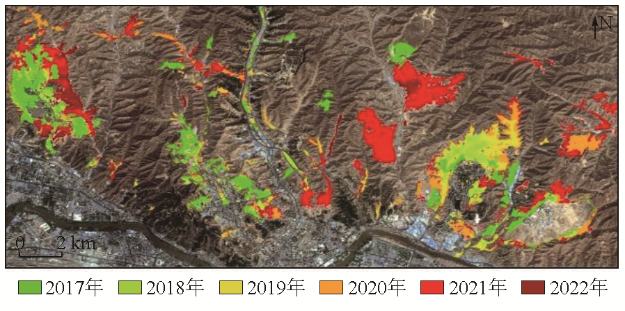
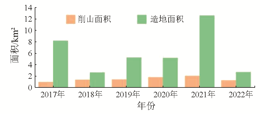
Hills cutting and land reclaiming (HCLR) serves as the most direct way for cities that are constrained by terrain to overcome land scarcity and facilitate urban spatial expansion. Obtaining the range of HCLR quickly and accurately using remote sensing technology is significant for assessing the regional ecosystem and new city development planning scientifically. Based on the Google Earth Engine (GEE) cloud computing platform for remote sensing, as well as multi-temporal data from Sentinel-1 SAR and Sentinel-2 multispectral imager (MSI), this study determined the spatiotemporal distribution of the 2017—2022 HCLR range in the study area using multi-temporal change monitoring and a random forest algorithm. Using a combination of Sentinel-1 ascending and descending images and based on noise filtering and multi-temporal image synthesis, this study calculated the difference in the backscattering intensity before and after HCLR. Then, the excavation range was determined using a threshold determined using the percentile threshold method combined with sample data. The results demonstrate that this method exhibited high operability, with an overall classification accuracy and Kappa coefficient of 85% and 0.83, respectively. By monitoring multi-temporal changes in the VH polarization band of Sentinel-1 and using a combination of Sentinel-1 ascending and descending images, this study acquired the spatial distribution of excavation areas within the study area from 2017 to 2022. Before 2019, the excavation areas were primarily concentrated in Jiuzhou Development Zone, Country Garden, and Poly Lingxiu Mountain. After 2020, new excavation areas, such as Liujiagou and Shuiyuan Station, emerged, with the scope and intensity of excavation gradually increasing. By combining the spectral, texture, and topographic features of SAR and optical data and based on feature optimization combined with a random forest algorithm, this study determined the spatial distribution of yearly HCLR from 2017 to 2022. Before 2018, the HCLR scale was small, with an area of 2.655 km2. After 2019, the scale increased each year, especially in 2021, when the area reached 12.607 km2, accounting for 34.56% of the total land reclamation area during the monitoring period. In 2022, the reclamation area obtained through further excavation on previously reclaimed land was estimated at only 2.686 km2 due to the increasing slope and excavation volume. The method developed in this study for monitoring excavation areas and extracting land reclaiming ranges enables effective monitoring and extraction of the HCLR range.
NIU Quanfu , LEI Jiaojiao , LIU Bo , WANG Hao , ZHANG Ruizhen , WANG Gang . Application of Sentinel-1/2 imagery in identifying hills cutting and land reclaiming in the Beishan Mountain of Lanzhou[J]. Remote Sensing for Natural Resources, 2025 , 37(1) : 142 -151 . DOI: 10.6046/zrzyyg.2023284
表1 特征变量Tab.1 Characteristic variables |
| 特征类型 | 特征变量 | 变量名称 | 变量描述/公式 |
|---|---|---|---|
| 光谱特征 | 波段 | B2,B3,B4,B5,B8,B8a,B11 | 蓝光、绿光、红光、红边、近红外、窄近红外、短波红外 |
| 指数特征 | 比值植被指数 归一化植被指数 归一化水体指数 归一化建筑指数 改进土壤调节植被指数 增强植被指数 裸露土壤覆盖程度指数 | RVI(ratio vegetation index) NDVI(normalized difference vegetation index) NDWI(normalized difference water index) NDBI(normalized difference built-up index) MSAVI(modified soil-adujsted vegetation index) EVI(enhancod vegetation index) BSI(bare soil index) | |
| 地形特征 | 高程 坡度 | DEM Slope | |
| 极化特征 | VV极化后向散射系数 VH极化后向散射系数 | | |
| 纹理特征 | 二阶矩 对比度 相关性 方差 逆差距 熵 | |
表2 2021年3种方案提取的开挖区统计精度Tab.2 Statistical accuracy of excavation area extracted by three schemes in 2021 |
| 方案精度 | 升轨 | 降轨 | 升轨+降轨组合 |
|---|---|---|---|
| OA/% | 77 | 73 | 85 |
| Kappa | 0.72 | 0.67 | 0.83 |
表3 获取SAR影像数Tab.3 Obtaining the number of SAR images |
| 监测年份 | 削山造地前时段/景 | 削山造地后时段/景 | ||
|---|---|---|---|---|
| 升轨 | 降轨 | 升轨 | 降轨 | |
| 2017年 | 2 | 3 | 5 | 8 |
| 2018年 | 5 | 8 | 5 | 9 |
| 2019年 | 5 | 9 | 5 | 10 |
| 2020年 | 5 | 10 | 5 | 15 |
| 2021年 | 5 | 15 | 5 | 10 |
| 2022年 | 5 | 10 | 5 | 10 |
表4 分类结果精度统计Tab.4 Accuracy statistics of classification results for each category (%) |
| 地类 | 评价 指标 | 组合方案 | ||||||
|---|---|---|---|---|---|---|---|---|
| 光谱 | 光谱 +指数 | 光谱 +纹理 | 光谱 +地形 | 光谱 +极化 | 全部 特征 | 优化 特征 | ||
| 削山造地 | PA | 84.2 | 89.0 | 85.0 | 80.0 | 79.1 | 86.5 | 92.1 |
| UA | 71.4 | 84.0 | 80.0 | 75.0 | 76.0 | 83.2 | 92.8 | |
| 建筑 | PA | 85.0 | 80.0 | 81.1 | 83.1 | 75.3 | 76.4 | 83.7 |
| UA | 75.7 | 80.4 | 85.6 | 75.2 | 80.0 | 71.3 | 83.2 | |
| 水体 | PA | 90.0 | 84.4 | 83.0 | 85.0 | 82.6 | 83.9 | 90.4 |
| UA | 83.2 | 87.4 | 82.3 | 89.0 | 86.6 | 85.4 | 90.9 | |
| 草地 | PA | 70.4 | 70.0 | 72.0 | 72.8 | 76.5 | 75.0 | 81.3 |
| UA | 68.3 | 67.0 | 88.0 | 67.6 | 82.4 | 75.0 | 77.7 | |
| 森林 | PA | 75.0 | 85.0 | 69.6 | 83.0 | 85.1 | 83.1 | 76.1 |
| UA | 75.0 | 85.2 | 68.0 | 78.7 | 82.2 | 82.2 | 77.2 | |
| 裸地 | PA | 72.6 | 87.0 | 69.9 | 78.8 | 71.6 | 79.5 | 82.9 |
| UA | 69.7 | 72.0 | 77.9 | 76.2 | 66.3 | 74.8 | 81.4 | |
| 耕地 | PA | 69.9 | 76.6 | 77.7 | 81.4 | 85.1 | 82.02 | 78.3 |
| UA | 71.3 | 88.2 | 73.6 | 74.4 | 81.5 | 78.7 | 81.1 | |
| [1] |
徐昔保, 杨桂山, 张建明. 兰州市城市土地利用优化研究[J]. 武汉大学学报(信息科学版), 2009, 34(7):878-881.
|
| [2] |
蒲小武, 王兰民, 吴志坚, 等. 兰州丘陵沟壑区挖方黄土高边坡面临的工程地质问题及稳定性分析[J]. 地震工程学报, 2016, 38(5):787-794.
|
| [3] |
|
| [4] |
|
| [5] |
白建荣. 兰州北山区域削山造地监测技术研究[R]. 甘肃省,甘肃省地图院,2018-05-29.
|
| [6] |
白建荣, 王桂钢, 杨腊梅. 兰州周边地区削山造地遥感监测及生态效应分析[J]. 测绘地理信息, 2020, 45(4):26-28.
|
| [7] |
何永刚, 巨擘. 基于Skyline的兰州削山造地监测三维系统设计与实现[J]. 矿山测量, 2018, 46(1):44-48,108.
|
| [8] |
赵元, 王华栋. 无人机倾斜摄影在削山造地快速监测中的应用[J]. 矿山测量, 2018, 46(3):27-30.
|
| [9] |
赵大卫, 贾永红, 白建荣, 等. 兰州北山区削山造地扬尘浓度预测方法及应用[J]. 武汉大学学报(信息科学版), 2021, 46(7):1106-1113.
|
| [10] |
高小龙, 白建荣, 王桂钢. 基于航空遥感数据的地形变化分析[J]. 地理空间信息, 2020, 18(3):79-81,86,7.
|
| [11] |
|
| [12] |
|
| [13] |
周珂, 杨永清, 张俨娜, 等. 光学遥感影像土地利用分类方法综述[J]. 科学技术与工程, 2021, 21(32):13603-13613.
|
| [14] |
|
| [15] |
|
| [16] |
张磊, 宫兆宁, 王启为, 等. Sentinel-2影像多特征优选的黄河三角洲湿地信息提取[J]. 遥感学报, 2019, 23(2):313-326.
|
| [17] |
|
| [18] |
罗卿莉, 崔峰志, 魏钜杰, 等. SAR影像变化检测的前景特征流形排序法[J]. 测绘学报, 2022, 51(11):2365-2378.
|
| [19] |
|
| [20] |
罗时雨, 童玲, 陈彦. 全极化SAR图像的山地低矮植被区域土壤含水量估计[J]. 遥感学报, 2017, 21(6):907-916.
|
| [21] |
张昊, 高小红, 史飞飞, 等. 基于Sentinel-2 MSI与Sentinel-1 SAR相结合的黄土高原西部撂荒地提取——以青海民和县为例[J]. 自然资源遥感, 2022, 34(4):144-154.doi:10.6046/zrzyyg.2021385.
|
| [22] |
|
| [23] |
|
| [24] |
|
| [25] |
|
| [26] |
|
| [27] |
宋宏利, 雷海梅, 尚明. 基于Sentinel 2A/B时序数据的黑龙港流域主要农作物分类[J]. 江苏农业学报, 2021, 37(1):83-92.
|
| [28] |
|
| [29] |
|
| [30] |
|
| [31] |
|
| [32] |
赵怡卿, 李玫洁, 吴瑕. 包头地区极端温度天气事件的百分位阈值计算与检验[J]. 农业灾害研究, 2023, 13(3):86-88.
|
| [33] |
|
| [34] |
帅爽, 张志, 张天, 等. 特征优化结合随机森林算法的干旱区植被高光谱遥感分类方法[J]. 农业工程学报, 2023, 39(9):287-293.
|
| [35] |
魏鑫, 任雨, 陈曦东, 等. 基于时序Sentinel-2数据水体动态变化监测——以河南省为例[J/OL]. 自然资源遥感, 2023:1-11.(2023-06-19)[2023-09-11].https://kns.cnki.net/kcms/detail/10.1759.P.20230619.1013.018.html.
|
| [36] |
|
| [37] |
|
| [38] |
|
| [39] |
|
| [40] |
|
/
| 〈 |
|
〉 |