
Remote Sensing for Natural Resources >
A study on time lags between groundwater changes and land subsidence based on GRACE and InSAR data
Received date: 2023-07-14
Revised date: 2023-10-17
Online published: 2026-06-03
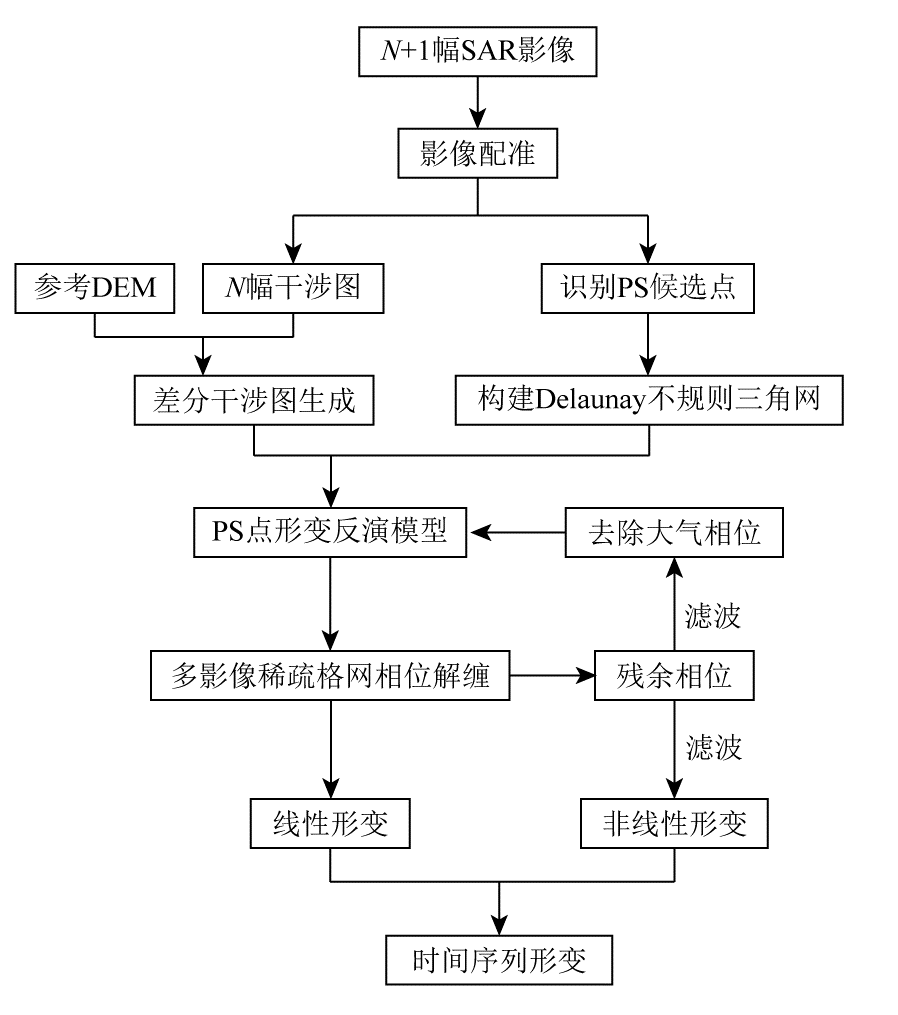
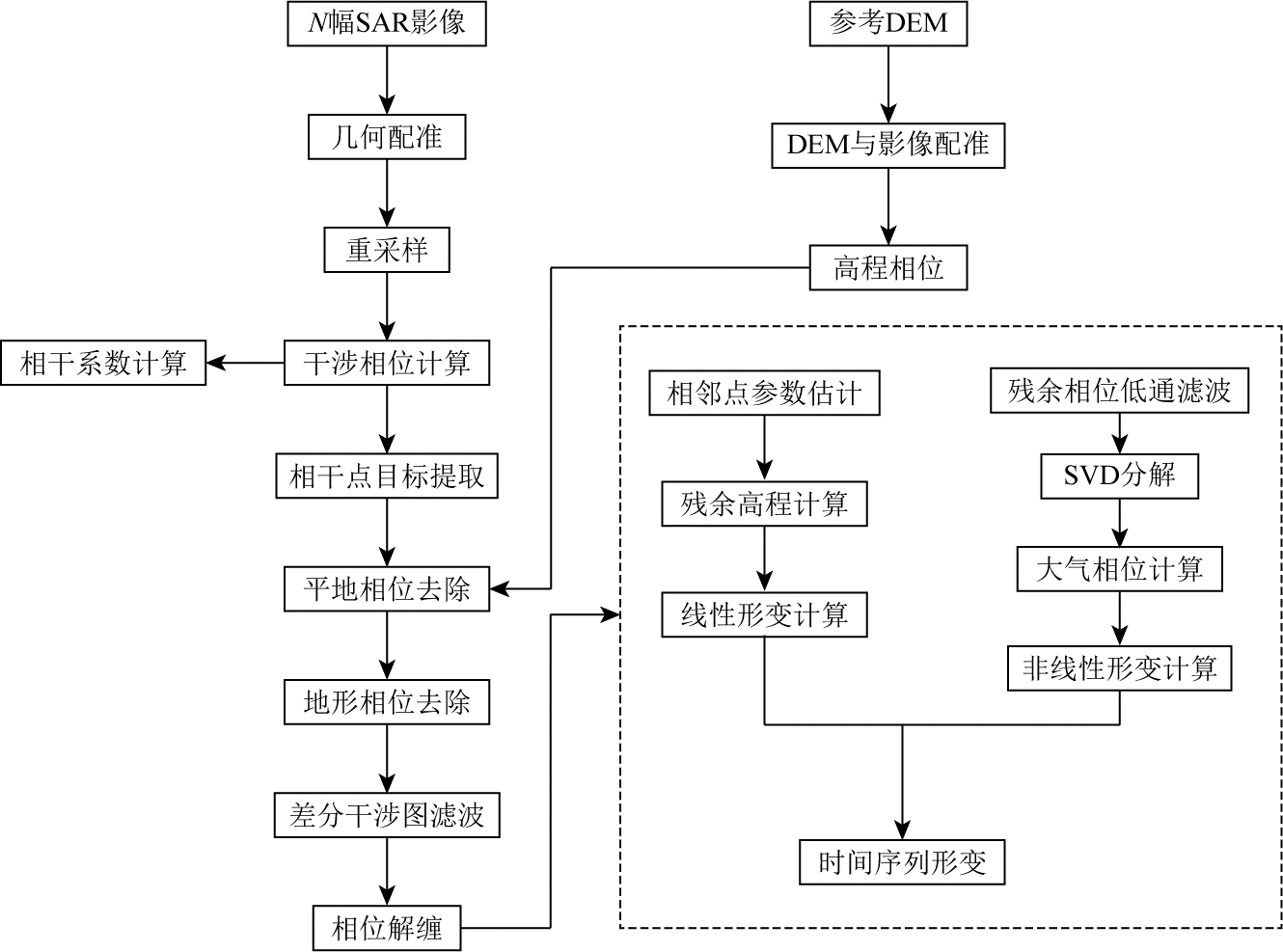
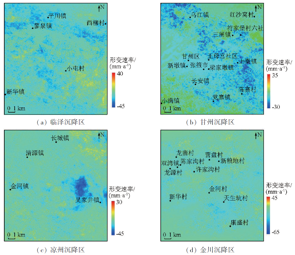
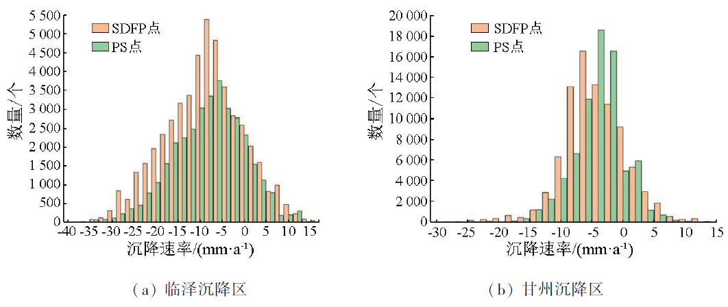
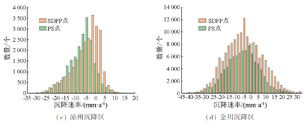
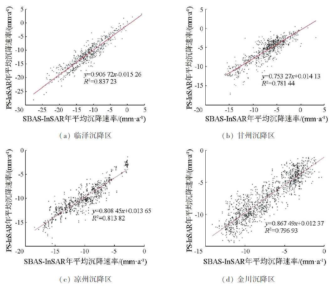
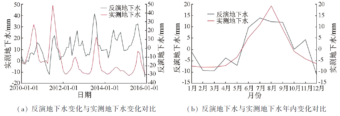
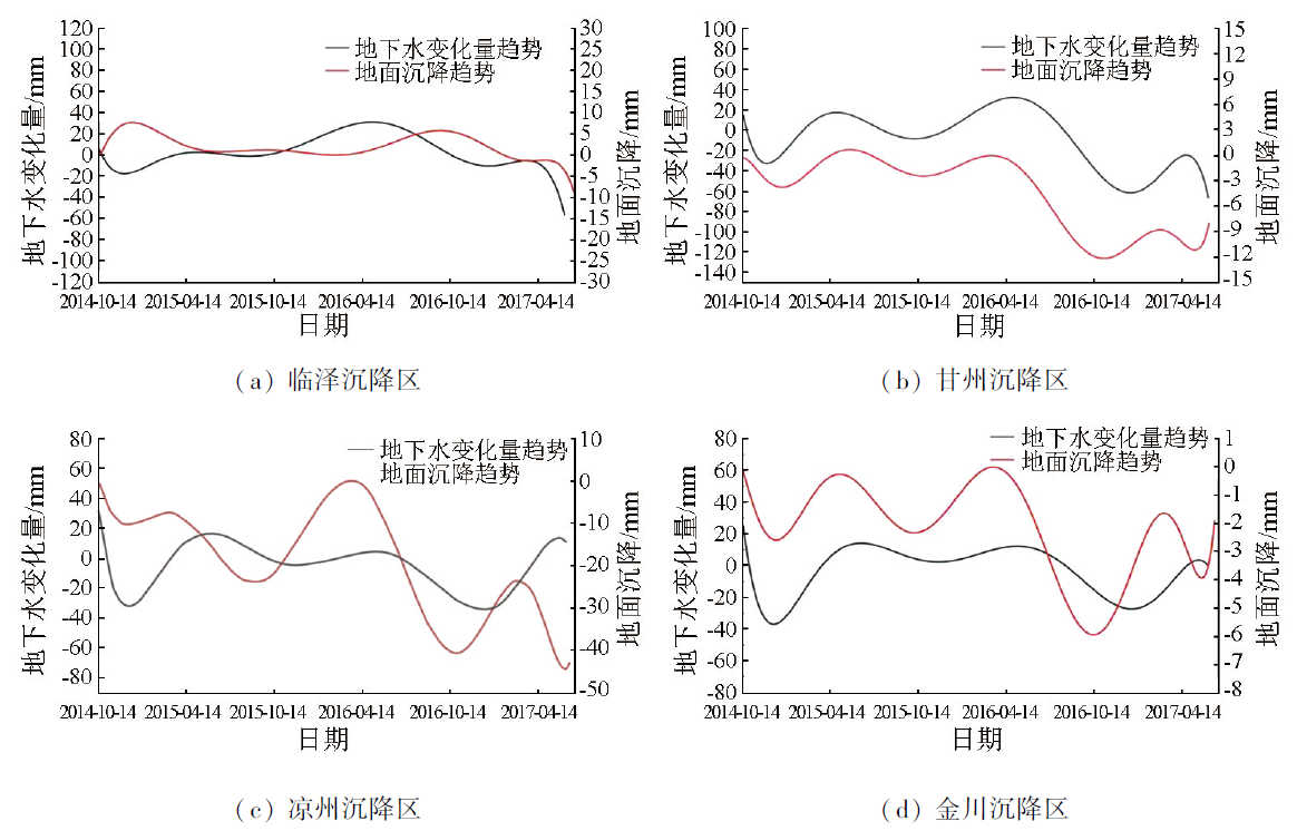
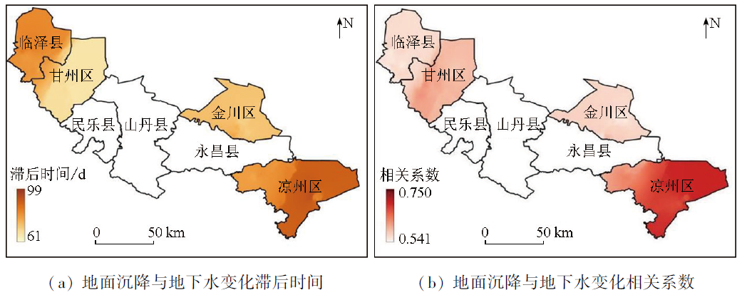
The increasing dependence on groundwater in the Hexi region has led to a significant drop in the groundwater table, which has induced land subsidence in some areas. Studying the relationship between groundwater changes and land subsidence hysteresis in the Hexi region holds great significance for local water resource management, land use planning, and agricultural development. This study determined the changing rate of groundwater in the study area from 2010 to 2017 using the GRACE and GLDAS data and verified the reliability of the inverted groundwater changes by combining measured data from monitoring wells. Then, this study derived the surface deformation rate of the local subsidence areas from October 2014 to June 2017 using the small baseline subset interferometric synthetic aperture radar (SBAS-InSAR) technique, as well as comparing and validating the results using the persistent scatterer interferometric synthetic aperture radar (PS-InSAR) technique. Finally, this study analyzed the relationship between groundwater changes and surface subsidence data using fast Fourier transform and time-delay correlation analysis. The results indicate that the time lags between land subsidence and groundwater changes were 74~86 d, 61~80 d, 80~99 d, and 74~99 d, respectively in the Linze, Ganzhou, Liangzhou, and Jinchuan subsidence areas, with respective correlation coefficients ranging from 0.541 to 0.593, from 0.589 to 0.689, from 0.600 to 0.750, and 0.543 to 0.630, respectively. The results of this study will provide a scientific basis for water resource management, land use planning, and agricultural development in the Hexi region.
Key words: GRACE; SBAS-InSAR; PS-InSAR; groundwater change; land subsidence; hysteresis
WEI Xiaoqiang , YANG Guolin , LIU Tao , SHAO Ming , MA Zhigang . A study on time lags between groundwater changes and land subsidence based on GRACE and InSAR data[J]. Remote Sensing for Natural Resources, 2025 , 37(1) : 122 -130 . DOI: 10.6046/zrzyyg.2023208
表1 地面沉降与地下水变化滞后时间Tab.1 Lag time of land subsidence compared with groundwater change |
| 地区 | 地表沉降速率/(mm·a-1) | 滞后时间/d |
|---|---|---|
| 临泽沉降区 | -36 ~-20 | 74~86 |
| 甘州沉降区 | -25 ~-10 | 61~80 |
| 凉州沉降区 | -30 ~-15 | 80~99 |
| 金川沉降区 | -45 ~-15 | 74~99 |
表2 地面沉降与地下水变化相关系数Tab.2 Correlation coefficient between land subsidence and groundwater change |
| 地区 | 时滞互相关系数 | 所占比例/% |
|---|---|---|
| 临泽沉降区 | 0.541~0.593 | 61.90 |
| 甘州沉降区 | 0.589~0.689 | 69.23 |
| 凉州沉降区 | 0.600~0.750 | 78.42 |
| 金川沉降区 | 0.543~0.630 | 68.30 |
| [1] |
于海若, 宫辉力, 陈蓓蓓, 等. 新水情下利用InSAR-GRACE卫星的新兴风险预警与城市地下空间安全展望[J]. 国土资源遥感, 2020, 32(4):16-22.doi:10.6046/gtzyyg.2020.04.03.
|
| [2] |
|
| [3] |
|
| [4] |
|
| [5] |
虎小强, 杨树文, 闫恒, 等. 基于时序InSAR的新疆阿希矿区地表形变监测与分析[J]. 自然资源遥感, 2023, 35(1):171-179.doi:10.6046/zrzyyg.2021415.
|
| [6] |
张庆洁, 赵争, 贾李博, 等. 黄河三角洲地面沉降现状及影响因素分析[J]. 测绘科学, 2022, 47(12):165-173.
|
| [7] |
|
| [8] |
|
| [9] |
|
| [10] |
|
| [11] |
费太政, 常晓涛, 朱广彬, 等. 利用GRACE与Sentinel-1反演地下水变化与地表沉降研究[J]. 测绘科学, 2023, 48(1):140-147.
|
| [12] |
李红英, 李岩瑛, 王云鹏, 等. 河西走廊西部沙尘暴时空差异及其动力分析[J]. 干旱区资源与环境, 2022, 36(10):104-112.
|
| [13] |
李平平. 甘肃省地下水超采区地面沉降控制区判定方法和结果探讨[J]. 中国农村水利水电, 2019(6):74-77.
|
| [14] |
|
| [15] |
|
| [16] |
|
| [17] |
|
| [18] |
|
| [19] |
|
| [20] |
|
| [21] |
杨国林, 孙学先, 胡栋, 等. 利用GRACE数据研究柴达木盆地区域水储量时空变化及干旱特征[J]. 导航定位学报, 2023, 11(1):107-112.
|
| [22] |
韦振锋, 任志远, 张翀. 气候因子与植被的时滞相关分析——以广西为例[J]. 生态环境学报, 2013, 22(11):1757-1762.
|
| [23] |
|
| [24] |
|
| [25] |
范军, 左小清, 李涛, 等. PS-InSAR和SBAS-InSAR技术对昆明主城区地面沉降监测的对比分析[J]. 测绘工程, 2018, 27(6):50-58.
|
/
| 〈 |
|
〉 |
