
Assessment of the applicability of CLDAS and GPM precipitation data for precipitation in Qinghai Province
Received date: 2025-03-21
Revised date: 2025-06-18
Online published: 2026-03-12
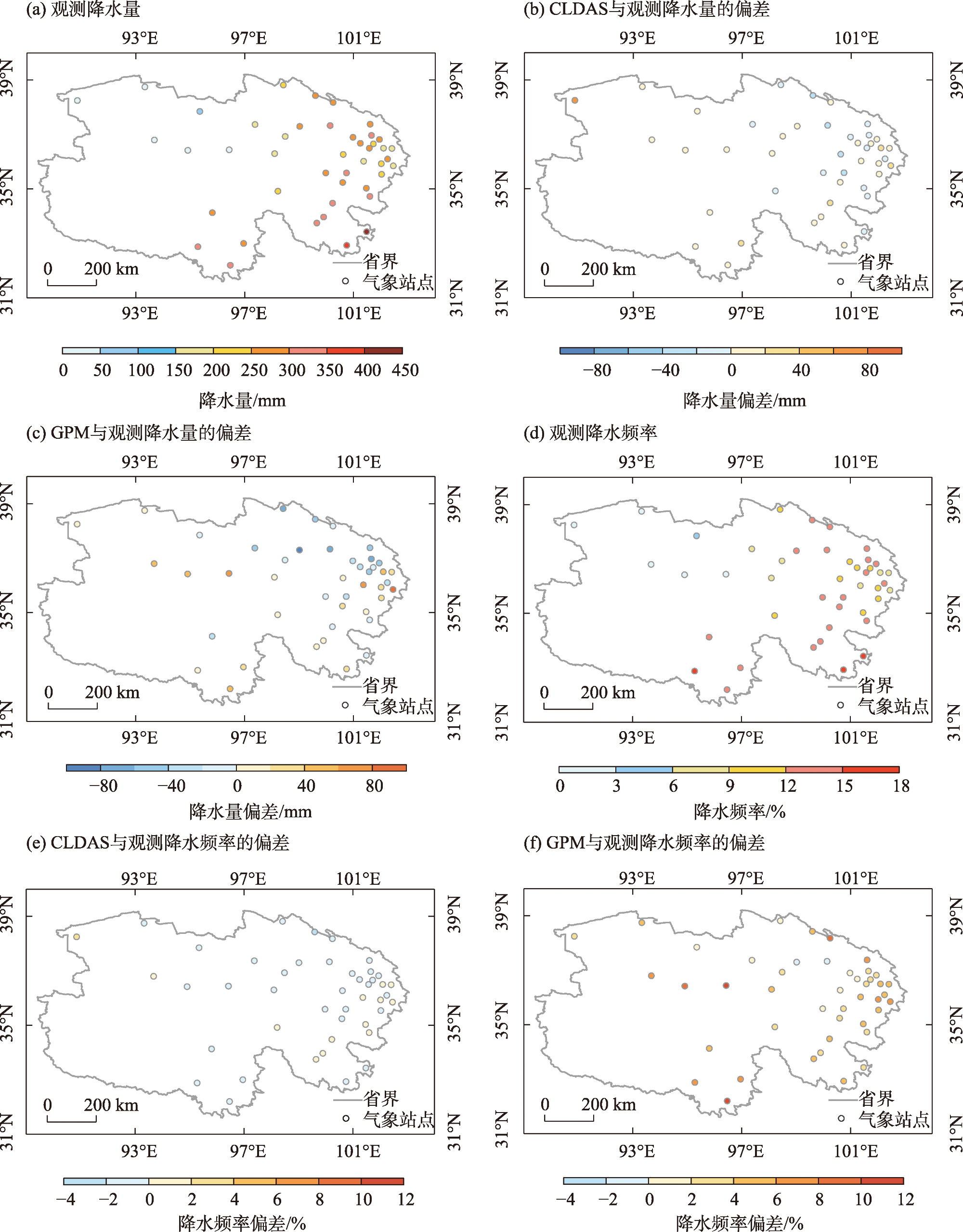
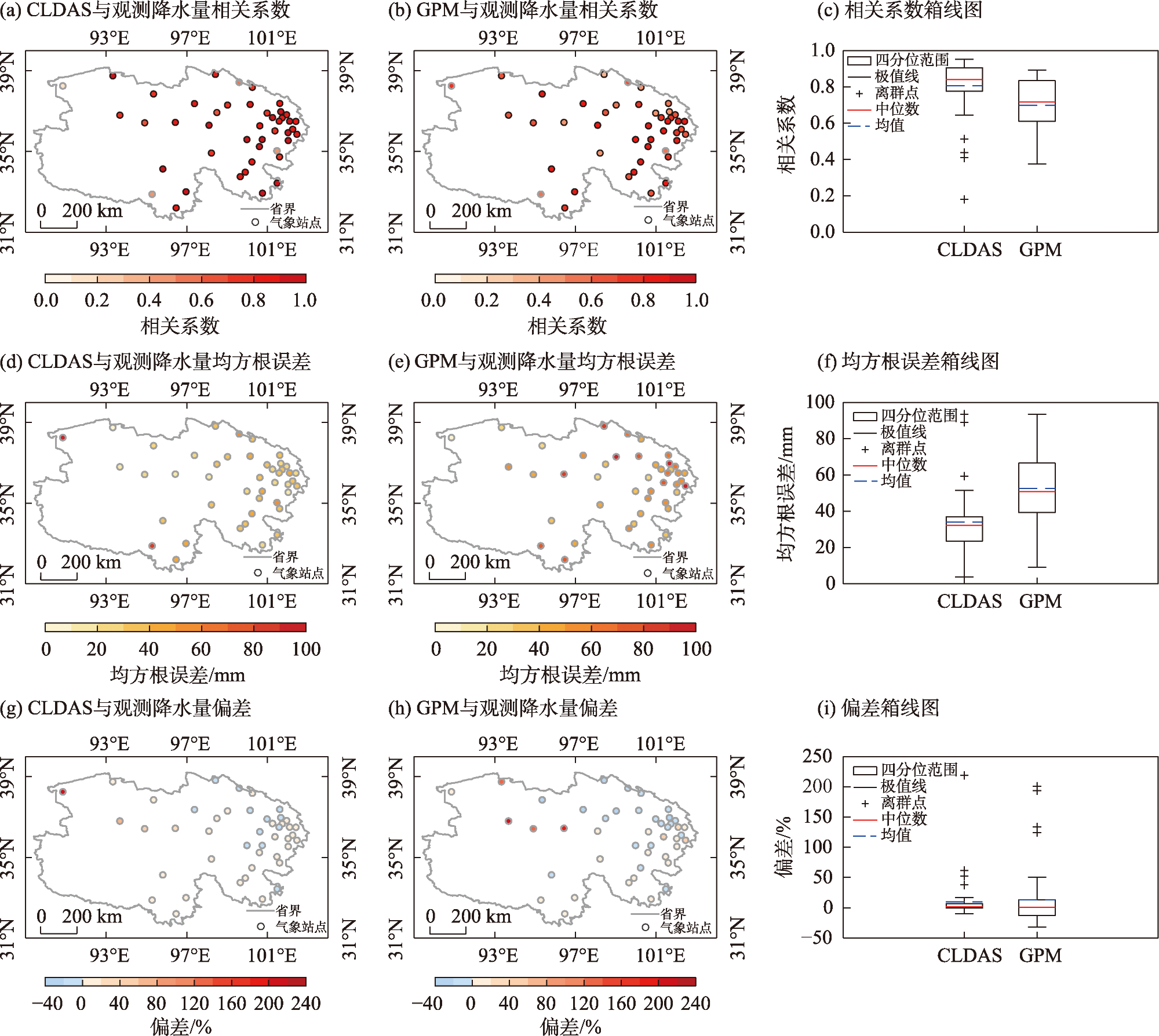
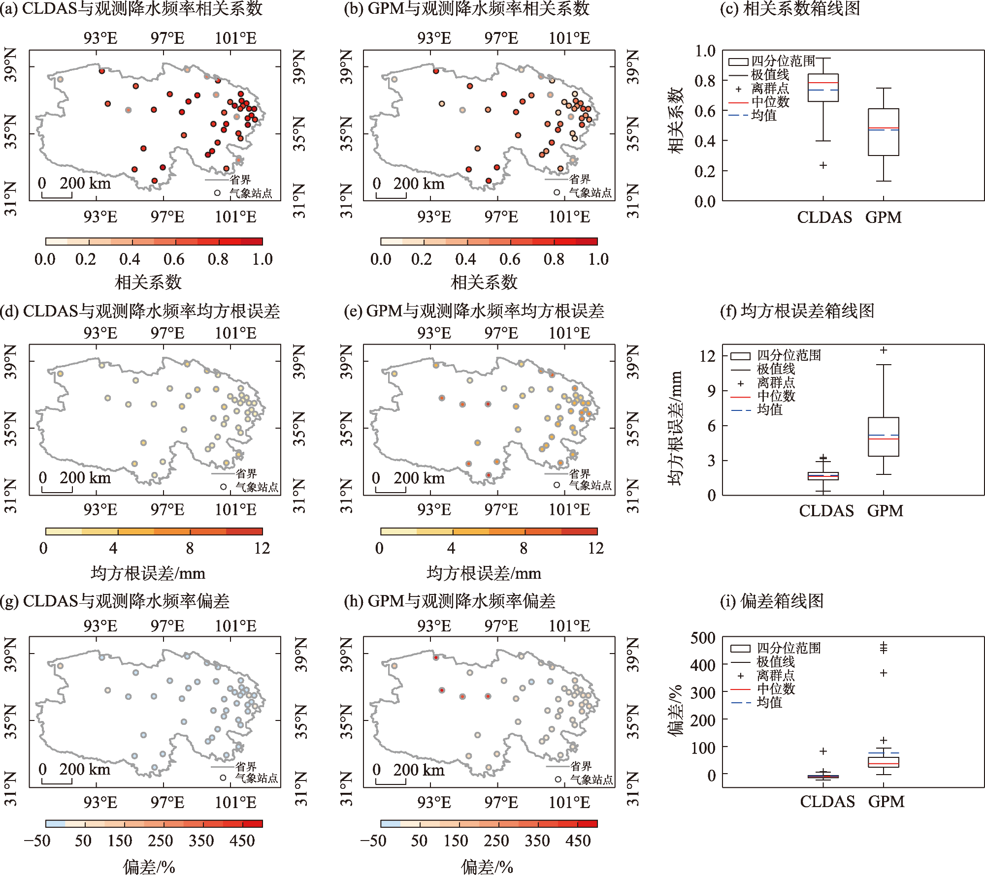
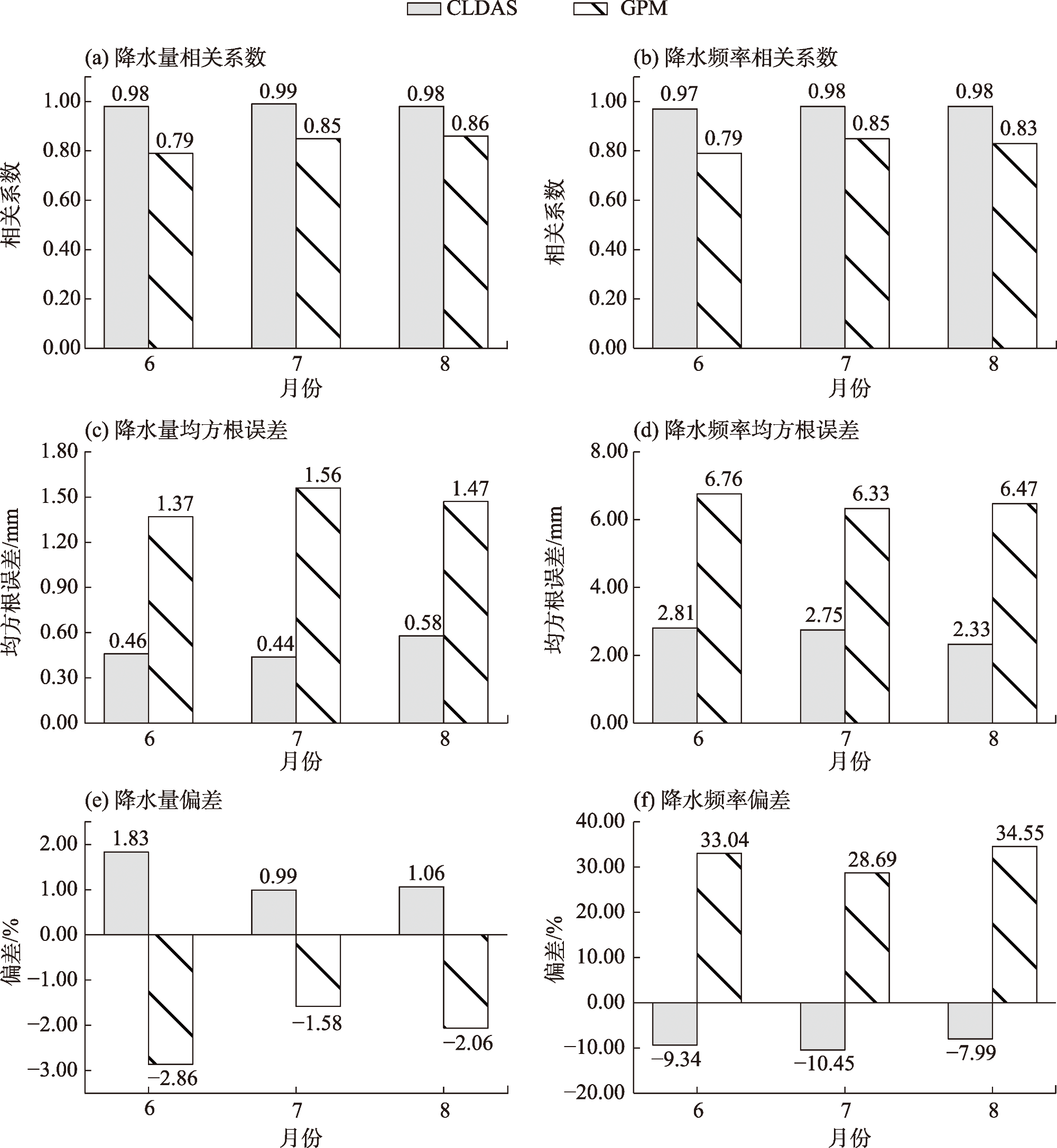
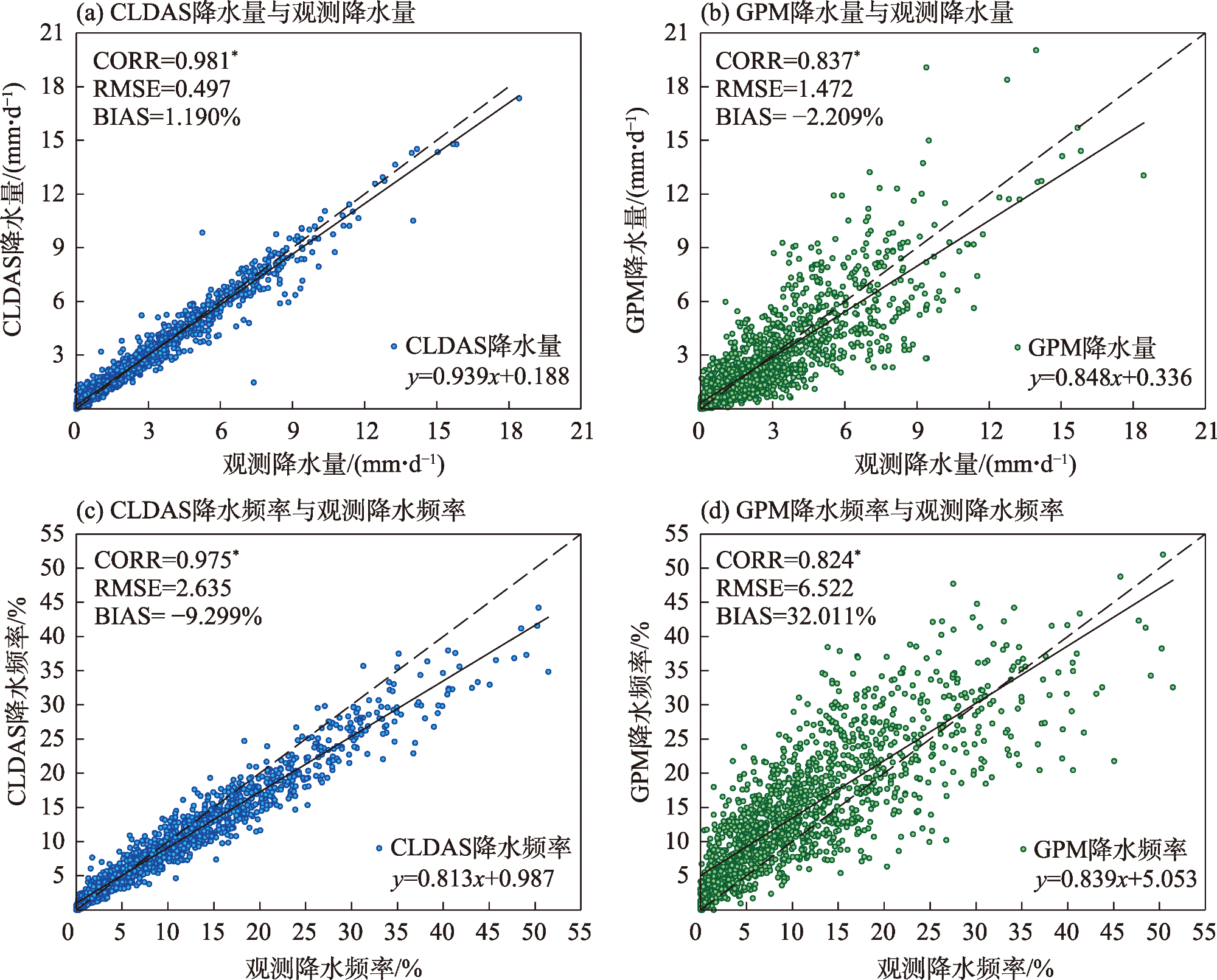
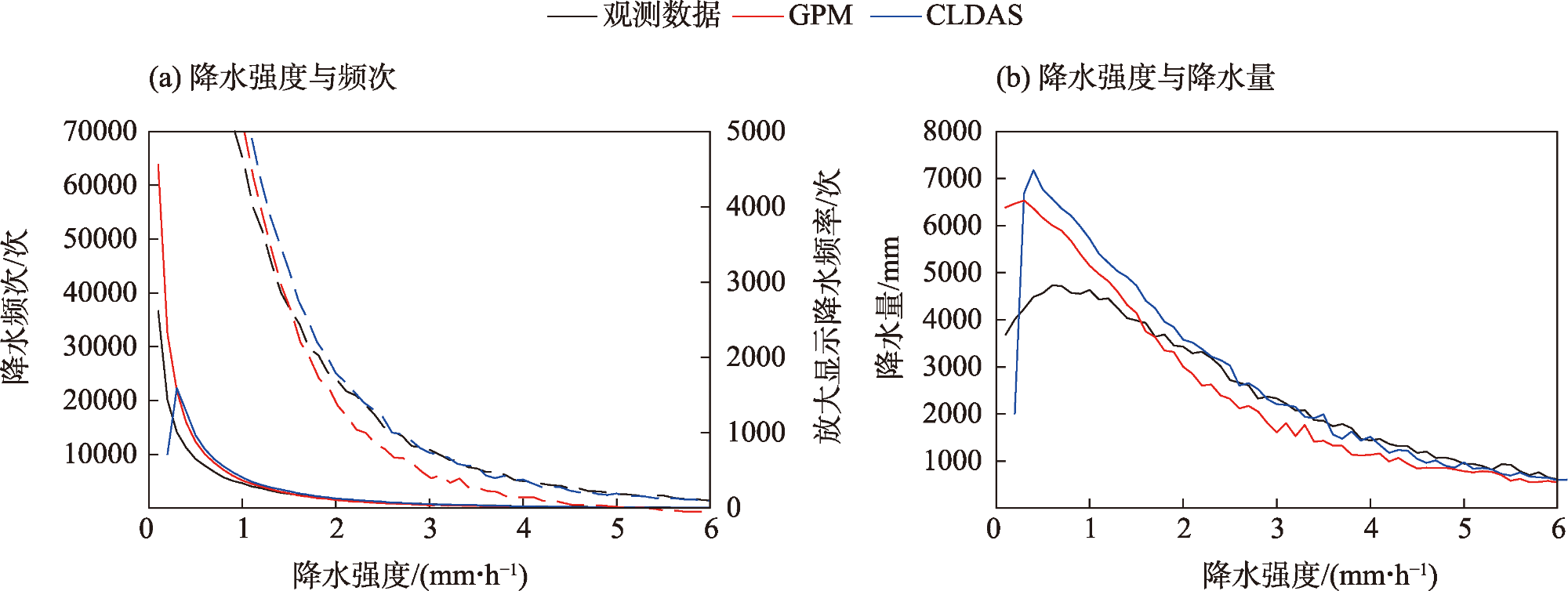
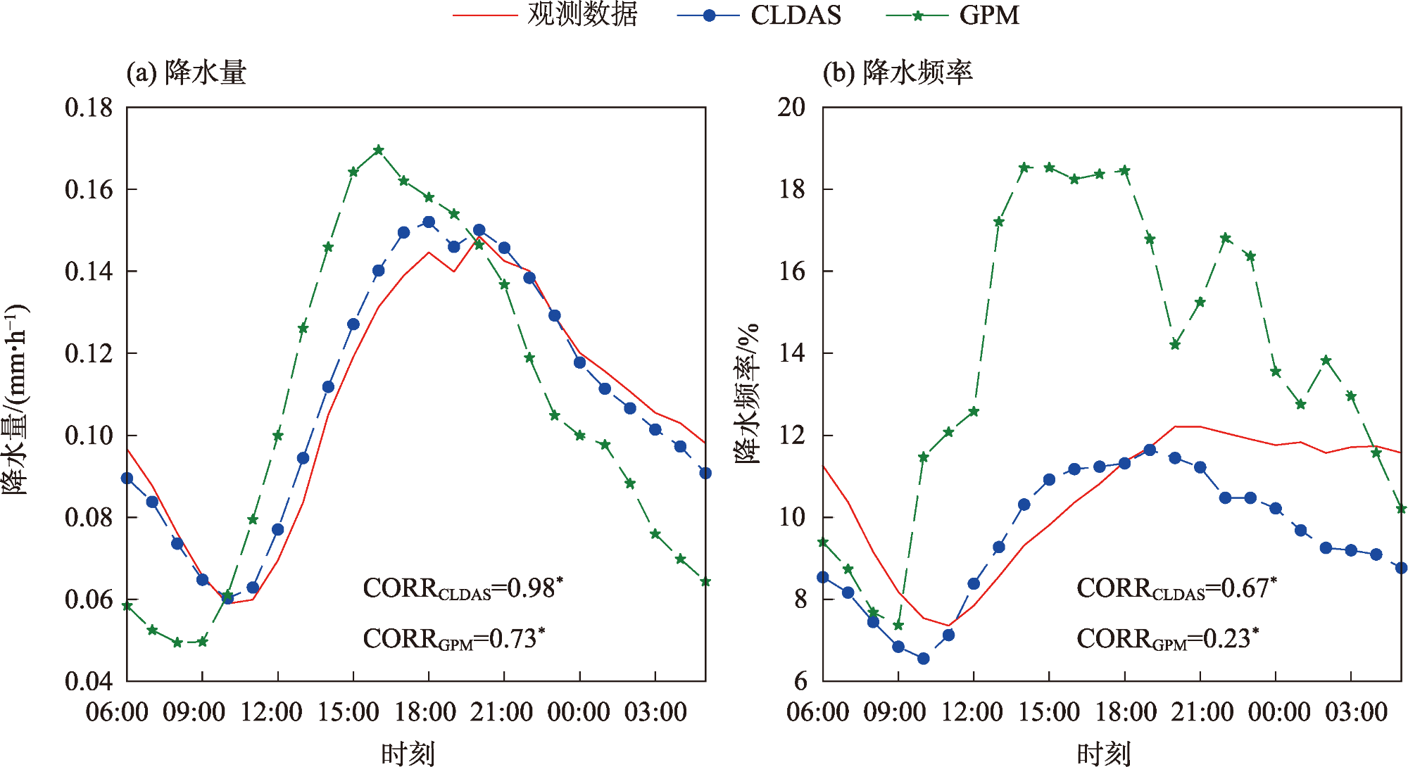
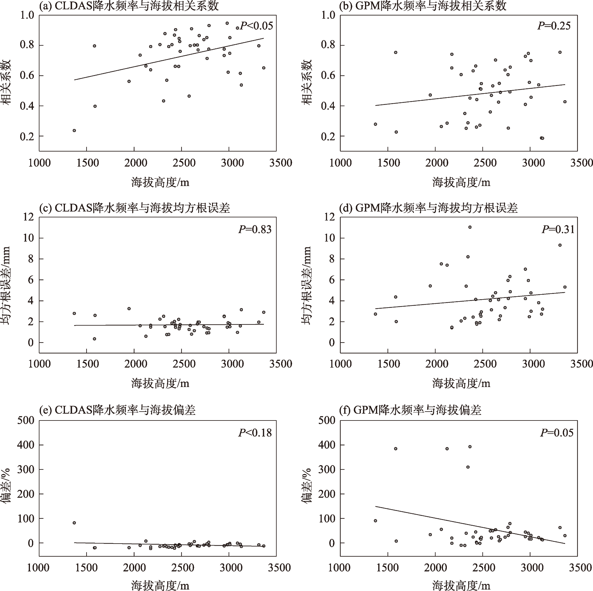
Based on summer hourly station observations in Qinghai from 2005 to 2021, this study evaluated the accuracy of China Meteorological Administration Land Data Assimilation System (CLDAS) and Global Precipitation Measurement (GPM) precipitation data across multiple dimensions, including temporal scales, diurnal variation, and elevation impacts. The results showed that: CLDAS outperformed GPM in overall accuracy. Both systems tended to overestimate the amount and frequency of light precipitation but underestimate these metrics for heavy precipitation. CLDAS better captured diurnal variations in precipitation amount/frequency and elevation-dependent patterns than GPM. However, CLDAS exhibited abnormally high values near major lakes. Correlations with elevation strengthened progressively for both products with increasing altitude, with CLDAS exhibiting a more significant trend in correlation enhancement. GPM overestimated the amount and frequency of precipitation at low elevations but underestimated these metrics at high elevations.
Key words: CLDAS; GPM; precipitation evaluation; altitude impact; Qinghai
SHEN Yanling , CAO Xiaomin , MA Yuancang , WANG Zhenhai . Assessment of the applicability of CLDAS and GPM precipitation data for precipitation in Qinghai Province[J]. Arid Zone Research, 2025 , 42(8) : 1379 -1383 . DOI: 10.13866/j.azr.2025.08.03
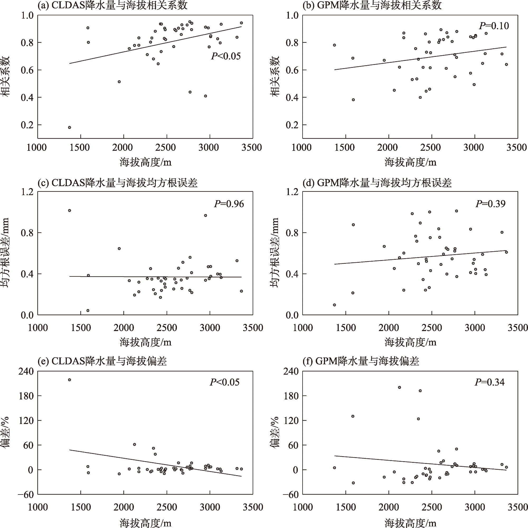
图10 2005—2021年青海省夏季降水量评估指标与海拔的关系Fig. 10 Relationship between summer precipitation amount indicators and elevation in Qinghai Province from 2005 to 2021 |
此次研究数据获取得到了中国气象科学研究院刘俏华同志的帮助,在此表示衷心的感谢!
| [1] |
黄建平, 刘玉芝, 王天河, 等. 青藏高原及周边地区气溶胶、云和水汽收支研究进展[J]. 高原气象, 2021, 40(6): 1225-1240.
[
|
| [2] |
尹泓琳. 三江源典型流域降雨—径流模拟及驱动因素研究[D]. 西宁: 青海大学, 2019.
[
|
| [3] |
谷昌军, 张镱锂, 刘林山, 等. 2000—2020年三江源草地绿度变化及其对气候变化的响应[J]. 地理科学, 2025, 45(1): 214-226.
[
|
| [4] |
|
| [5] |
|
| [6] |
|
| [7] |
金晓龙, 邵华, 张弛, 等. GPM 卫星降水数据在天山山区的适用性分析[J]. 自然资源学报, 2016, 31(12): 2074-2085.
[
|
| [8] |
|
| [9] |
|
| [10] |
师春香, 谢正辉. 基于静止气象卫星观测的降水时间降尺度研究[J]. 地理科学进展, 2008, 27(4): 15-22.
[
|
| [11] |
张蒙, 黄安宁, 计晓龙, 等. 卫星反演降水资料在青藏高原地区的适用性分析[J]. 高原气象, 2016, 35(1): 34-42.
[
|
| [12] |
|
| [13] |
余坤伦, 张寅生, 马宁, 等. GPM和TRMM遥感降水产品在青藏高原中部的适用性评估[J]. 干旱区研究, 2018, 35(6): 1373-1381.
[
|
| [14] |
|
| [15] |
|
| [16] |
|
| [17] |
|
| [18] |
|
| [19] |
|
| [20] |
|
| [21] |
|
| [22] |
粟运, 师春香, 毛文书, 等. 基于CLDAS-Prcp多源融合降水产品的WRF-Hydro模式在綦江流域的水文效用[J]. 高原气象, 2022, 41(3): 617-629.
[
|
| [23] |
|
| [24] |
|
| [25] |
唐国强, 万玮, 曾子悦, 等. 全球降水测量(GPM)计划及其最新进展综述[J]. 遥感技术与应用, 2015, 30(4): 607-615.
[
|
| [26] |
任鹏臻, 邸少宇, 刘锐, 等. GPM IMERG卫星降水数据在青海的适用性评价[J]. 青海大学学报, 2024, 42(4): 56-63.
[
|
| [27] |
中国气象局. 地面气象观测规范[M]. 北京: 气象出版社, 2003.
[China Meteorological Administration. The Criterion of Surface Meteorological Observation[M]. Beijing: China Meteorological Press, 2003.]
|
| [28] |
|
| [29] |
|
| [30] |
|
| [31] |
|
| [32] |
吴璐. 青藏高原与其东侧四川盆地降水日变化差异研究[D]. 北京: 中国气象科学研究院, 2012.
[
|
| [33] |
白爱娟, 刘长海, 刘晓东, 等. TRMM多卫星降水分析资料揭示的青藏高原及其周边地区夏季降水日变化[J]. 地球物理学报, 2008, 51(3): 704-714.
[
|
| [34] |
|
| [35] |
|
| [36] |
|
| [37] |
|
| [38] |
|
| [39] |
|
/
| 〈 |
|
〉 |
