
Driving factors analysis and multi-scenario simulation of land use change based on GeoDetector-Mixed-cell Cellular Automata: A case of the Gansu section in the Yellow River Basin
Received date: 2024-09-04
Revised date: 2025-02-26
Online published: 2025-08-14
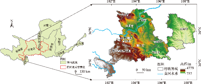
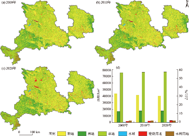
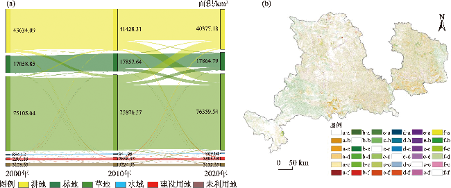
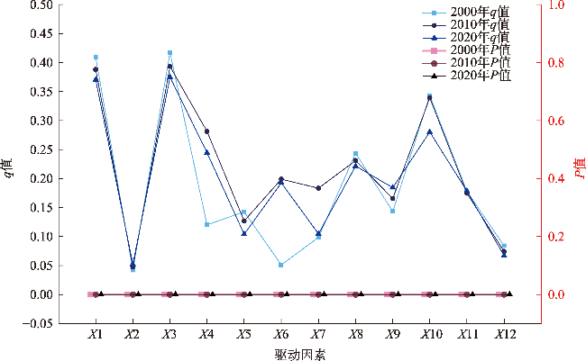
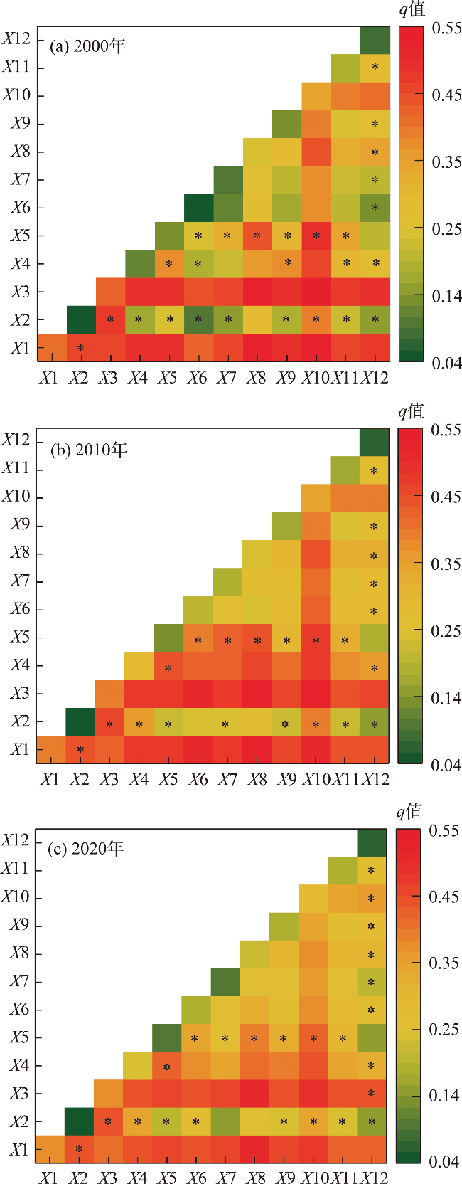
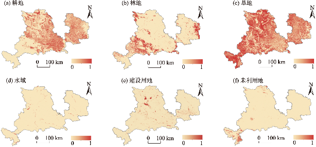
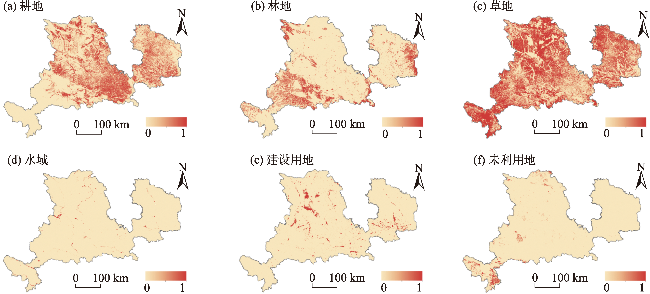
Land resources are the most fundamental production factors for human survival and development. Investigating the driving factors of land use change and simulating future land use scenarios are of great significance for regional sustainable development. Taking the Gansu section in the Yellow River Basin as the research area, this paper, based on multi-source data, employs methods such as the land use transfer matrix, GeoDetector, and the Mixed-cell Cellular Automata (MCCA) model to reveal the evolution characteristics of land use and conduct multi-scenario simulations for 2035. The results are as follows: (1) From 2000-2020, the land use/cover in the research area mainly comprised cultivated land, forest land, and grassland. The extent of forest and grassland cover was relatively high, and the area of cultivated land decreased significantly. Moreover, the conversion between cultivated land and grassland was the most obvious. (2) The dominant factors influencing land use change of the Gansu section in the Yellow River Basin include elevation, temperature, precipitation, distance from rural settlements, and population density. The q-values of the interaction effects of all driving factors have increased. (3) The MCCA model exhibits high simulation accuracy, with an overall accuracy of 0.903. In 2035, the simulation results vary among scenarios. Under the natural evolution scenario, cultivated land and unused land contract, while other land types expand. Under the cultivated land protection scenario, the current stock of cultivated land is maintained, but the area of grassland decreases significantly. In the ecological priority scenario, the areas of forest land and grassland increase significantly. The economic development scenario is manifested in a more aggressive development paradigm, under which construction land experiences a remarkable expansion. The research results provide references for land management and high-quality development of the Gansu section in the Yellow River Basin.
ZHANG Yan , YANG Weixin , LYU Tao . Driving factors analysis and multi-scenario simulation of land use change based on GeoDetector-Mixed-cell Cellular Automata: A case of the Gansu section in the Yellow River Basin[J]. Arid Zone Research, 2025 , 42(4) : 668 -681 . DOI: 10.13866/j.azr.2025.04.09
表1 黄河流域甘肃段土地利用程度分级Tab. 1 Land use intensity classification of the Gansu section in the Yellow River Basin |
| 土地利用类型 | 未利用地 | 林地、草地、水域 | 耕地 | 建设用地 |
|---|---|---|---|---|
| 分级指数 | 1 | 2 | 3 | 4 |
表2 情景构建Tab. 2 Situation construction |
| 情景类型 | 设置依据 | 描述 |
|---|---|---|
| 自然演变情景 | 遵循历史惯性 | 以黄河流域甘肃段2005—2020年土地利用数据为基础利用MCCA模型线性回归模块得到预期土地利用结构占比,不考虑政策等其他约束作用 |
| 耕地保护情景 | 国家粮食安全战略、耕地保护政策 | 严守耕地红线,控制耕地数量,响应国家粮食安全战略,保证区域粮食安全。该情景降低耕地向外转换强度,并减缓建设用地的增长速率 |
| 生态优先情景 | 国土空间生态修复、黄河流域生态保护 | 该情景重点考虑生态环境,强化生态用地保护和多元化利用,将林地、水域预期面积提高5%,且禁止林地、草地、水域转变为建设用地 |
| 经济发展情景 | 城镇化发展动力强劲,建设用地需求增大 | 强调以经济发展和城市建设为核心,保持高速增长的态势,将建设用地预期面积提高至2020年的1.3倍,并减缓耕地、水域的缩减速率 |
表3 模拟情景的转移矩阵Tab. 3 Transition matrix for simulated scenarios |
| 2020— 2035年 | 自然演变 | 耕地保护 | 生态优先 | 经济发展 | |||||||||||||||||||||||
|---|---|---|---|---|---|---|---|---|---|---|---|---|---|---|---|---|---|---|---|---|---|---|---|---|---|---|---|
| a | b | c | d | e | f | a | b | c | d | e | f | a | b | c | d | e | f | a | b | c | d | e | f | ||||
| a | 1 | 1 | 1 | 0 | 1 | 0 | 1 | 0 | 0 | 0 | 0 | 0 | 1 | 1 | 1 | 0 | 1 | 0 | 1 | 1 | 1 | 0 | 1 | 0 | |||
| b | 1 | 1 | 1 | 0 | 0 | 0 | 1 | 1 | 1 | 0 | 1 | 0 | 0 | 1 | 0 | 0 | 0 | 0 | 1 | 1 | 1 | 0 | 1 | 0 | |||
| c | 1 | 1 | 1 | 1 | 1 | 1 | 1 | 1 | 1 | 1 | 1 | 1 | 0 | 1 | 1 | 0 | 0 | 0 | 1 | 1 | 1 | 1 | 1 | 1 | |||
| d | 1 | 0 | 1 | 1 | 1 | 0 | 1 | 0 | 1 | 1 | 1 | 0 | 0 | 0 | 0 | 1 | 0 | 0 | 1 | 0 | 1 | 1 | 1 | 0 | |||
| e | 1 | 0 | 0 | 0 | 1 | 0 | 1 | 0 | 0 | 0 | 1 | 0 | 1 | 0 | 1 | 1 | 1 | 0 | 0 | 0 | 0 | 0 | 1 | 0 | |||
| f | 1 | 1 | 1 | 1 | 1 | 1 | 1 | 1 | 1 | 1 | 1 | 1 | 1 | 1 | 1 | 1 | 1 | 1 | 1 | 1 | 1 | 1 | 1 | 1 | |||
注:a表示耕地,b表示林地,c表示草地,d表示水域,e表示建设用地,f表示未利用地;0表示两种土地利用类型之间无法转换,1表示可以转换。 |
表4 2020年与2035年多情景土地利用面积动态变化Tab. 4 Dynamic changes of land use area under multiple scenarios in 2020 and 2035 |
| 土地利用类型 | 2020年 | 2035年 | ||||||||||||
|---|---|---|---|---|---|---|---|---|---|---|---|---|---|---|
| 利用现状 | 自然演变 | 耕地保护 | 生态优先 | 经济发展 | ||||||||||
| 面积/km2 | 占比/% | 面积/km2 | 占比/% | 面积/km2 | 占比/% | 面积/km2 | 占比/% | 面积/km2 | 占比/% | |||||
| 耕地 | 40377.18 | 28.43 | 38710.09 | 27.26 | 40416.20 | 28.46 | 39016.95 | 27.47 | 39329.49 | 27.69 | ||||
| 林地 | 17864.79 | 12.58 | 17898.04 | 12.60 | 17924.73 | 12.62 | 18323.39 | 12.91 | 18136.55 | 12.77 | ||||
| 草地 | 76359.54 | 53.77 | 77274.01 | 54.41 | 75821.99 | 53.39 | 77316.72 | 54.44 | 76276.51 | 53.71 | ||||
| 水域 | 969.04 | 0.68 | 995.78 | 0.70 | 947.74 | 0.67 | 1009.80 | 0.71 | 1005.10 | 0.71 | ||||
| 建设用地 | 3308.93 | 2.33 | 4153.44 | 2.92 | 3951.87 | 2.77 | 3852.74 | 2.71 | 4285.56 | 3.02 | ||||
| 未利用地 | 3132.55 | 2.21 | 2980.67 | 2.10 | 2949.52 | 2.08 | 2492.42 | 1.76 | 2978.83 | 2.10 | ||||
| [1] |
崔国屹, 张艳, 晁阳, 等. 秦岭地区近40年土地利用变化及其生态环境效应[J]. 水土保持研究, 2023, 30(1): 319-326.
[
|
| [2] |
|
| [3] |
白娥, 薛冰. 土地利用与土地覆盖变化对生态系统的影响[J]. 植物生态学报, 2020, 44(5): 543-552.
[
|
| [4] |
王鹏, 秦思彤, 胡慧蓉. 近30 a拉萨河流域土地利用变化和生境质量的时空演变特征[J]. 干旱区研究, 2023, 40(3): 492-503.
[
|
| [5] |
高宇婷, 于洋, 孙凌霄, 等. 塔里木盆地南缘绿洲土地覆盖变化及驱动力[J]. 干旱区研究, 2021, 38(4): 1172-1183.
[
|
| [6] |
郝晓敬, 张红, 徐小明, 等. 晋北地区土地利用覆被格局的演变与模拟[J]. 生态学报, 2020, 40(1): 257-265.
[
|
| [7] |
张浚茂, 臧传富. 东南诸河流域1990—2015年土地利用时空变化特征及驱动机制[J]. 生态学报, 2019, 39(24): 9339-9350.
[
|
| [8] |
邓元杰, 侯孟阳, 张晓, 等. 基于Logistic回归模型的陕西秦巴山区林地变化驱动力分析[J]. 南京林业大学学报(自然科学版), 2022, 46(1): 106-114.
[
|
| [9] |
张启扬, 刘仁志, 栾朝旭. 基于PLUS模型的典型农牧交错带土地利用驱动力分析与多情景模拟[J]. 水土保持研究, 2025, 32(1): 368-378.
[
|
| [10] |
杨丽萍, 张静, 贡恩军, 等. GEE联合多源数据的西安市土地利用时空格局及驱动力分析[J]. 农业工程学报, 2022, 38(2): 279-288.
[
|
| [11] |
刘彦随, 李进涛. 中国县域农村贫困化分异机制的地理探测与优化决策[J]. 地理学报, 2017, 72(1): 161-173.
[
|
| [12] |
王萍, 林乐乐, 彭杨靖, 等. 基于CLUE-S模型的浙江省土地利用结构变化趋势分析[J]. 生态科学, 2024, 43(3): 196-206.
[
|
| [13] |
祁育汀, 张平, 刘雷, 等. 关中平原城市群土地利用结构多情景优化和生态系统服务价值预测[J]. 应用生态学报, 2023, 34(9): 2507-2517.
[
|
| [14] |
黎云云, 畅建霞, 王义民, 等. 基于CA-Markov模型的黄河流域土地利用模拟预测研究[J]. 西北农林科技大学学报(自然科学版), 2020, 48(12): 107-116.
[
|
| [15] |
兰健, 渠立权. 未来10年珠江流域土地利用多情景模拟及碳储量评估[J]. 水土保持学报, 2024, 38(3):266-275.
[
|
| [16] |
张寒冰, 高阳, 崔艳智. 基于风沙防治的典型农牧交错区土地利用多情景模拟[J]. 环境科学研究, 2019, 32(6): 1081-1089.
[
|
| [17] |
王丹, 兰安军, 范泽孟, 等. 典型喀斯特区域土地利用变化对生态系统服务价值的响应情景模拟[J]. 水土保持研究, 2024, 31(4): 308-315, 325.
[
|
| [18] |
唐相龙, 蔡乐山, 张博文. 生态过渡带土地利用及生态系统服务价值多情景模拟:以甘肃省为例[J/OL]. 生态与农村环境学报, 1-15. https://doi.org/10.19741/j.issn.1673-4831.2024.0439.
[
|
| [19] |
|
| [20] |
王端睿, 毛德华, 王宗明, 等. 东北地区土地覆被格局变化模拟:基于CLUE-S和Markov-CA模型的对比分析[J]. 地理科学, 2024, 44(2): 329-339.
[
|
| [21] |
王旭东, 姚尧, 任书良, 等. 耦合FLUS和Markov的快速发展城市土地利用空间格局模拟方法[J]. 地球信息科学学报, 2022, 24(1): 100-113.
[
|
| [22] |
陶伟, 刘译泽, 孙清, 等. 基于GeoSOS模型的金华市土地利用变化动态模拟[J]. 浙江师范大学学报(自然科学版), 2024, 47(3): 249-256.
[
|
| [23] |
张艳, 李骏南, 潘博华. 基于PLUS模型的黄河流域生态系统服务评价及多情景预测——以陕西段为例[J]. 干旱区地理, 2024, 47(11): 1935-1946.
[
|
| [24] |
|
| [25] |
|
| [26] |
蒋小芳, 段翰晨, 廖杰, 等. 基于多模型的黑河中游甘临高地区土地利用情景模拟[J]. 农业机械学报, 2022, 53(9): 178-188.
[
|
| [27] |
田云, 刘俊艳, 白爽, 等. 近20年黄河流域甘肃段植被覆盖度变化与驱动因素分析[J]. 农业机械学报, 2024, 55(7): 365-372, 404.
[
|
| [28] |
戴文渊, 玛久草, 陈亦晨, 等. 黄河流域甘肃段水生态安全驱动力分析及动态演变[J]. 干旱区研究, 2024, 41(10): 1662-1671.
[
|
| [29] |
陆莹, 张敏, 王彦阁. 内蒙古黄河流域生态保护恢复优先区识别[J]. 干旱区研究, 2024, 41(11): 1946-1955.
[
|
| [30] |
程玉恒, 乔伟峰, 何天祺, 等. 南京市高淳区村域尺度土地利用功能变化及生态系统服务价值响应研究[J]. 地理科学, 2024, 44(2): 340-350.
[
|
| [31] |
王思远, 刘纪远, 张增祥, 等. 中国土地利用时空特征分析[J]. 地理学报, 2001, 56(6): 631-639.
[
|
| [32] |
苏泽琛, 邵战林. 干旱区土地利用变化对耕地空间的影响及预测——以昌吉市为例[J]. 干旱区研究, 2024, 41(11): 1936-1945.
[
|
| [33] |
王劲峰, 徐成东. 地理探测器: 原理与展望[J]. 地理学报, 2017, 72(2): 116-134.
[
|
| [34] |
李楚瑜, 徐伟铭, 王开家, 等. 基于MCCA的多情景土地利用演变及其ESV变化研究——以龙岩市为例[J]. 贵州大学学报(自然科学版), 2023, 40(5): 114-124.
[
|
| [35] |
胡丰, 陈瑶, 张长春, 等. 基于MCCA土地利用情景模拟的太行山区生态系统服务价值时空演变及预测[J]. 环境科学, 2024, 45(10): 5912-5923.
[
|
| [36] |
许月卿, 罗鼎, 郭洪峰, 等. 基于CLUE-S模型的土地利用空间布局多情景模拟研究——以甘肃省榆中县为例[J]. 北京大学学报(自然科学版), 2013, 49(3): 523-529.
[
|
| [37] |
张恩月, 郑君焱, 苏迎庆, 等. 基于情景模拟的流域低碳土地利用格局优化研究——以汾河流域为例[J]. 干旱区研究, 2023, 40(2): 203-212.
[
|
| [38] |
张舟, 刘晶晶, 张权, 等. 基于PLUS-InVEST-Geodector模型的苏州市碳储量时空变化及驱动力分析[J/OL]. 环境科学, 1-17. https://doi.org/10.13227/j.hjkx.202405077.
[
|
| [39] |
黄钰清, 李骁尧, 于强, 等. 1995—2018年黄河流域土地利用变化及驱动力分析[J]. 西北林学院学报, 2022, 37(6): 113-121.
[
|
| [40] |
张佰发, 苗长虹. 黄河流域土地利用时空格局演变及驱动力[J]. 资源科学, 2020, 42(3): 460-473.
[
|
| [41] |
胡丰, 张艳, 郭宇, 等. 基于PLUS和InVEST模型的渭河流域土地利用与生境质量时空变化及预测[J]. 干旱区地理, 2022, 45(4): 1125-1136.
[
|
/
| 〈 |
|
〉 |