
Research on the alert area of Kyagar Glacier-dammed Lake outburst floods in the Karakoram Mountains
Received date: 2024-08-10
Revised date: 2025-02-19
Online published: 2025-08-14
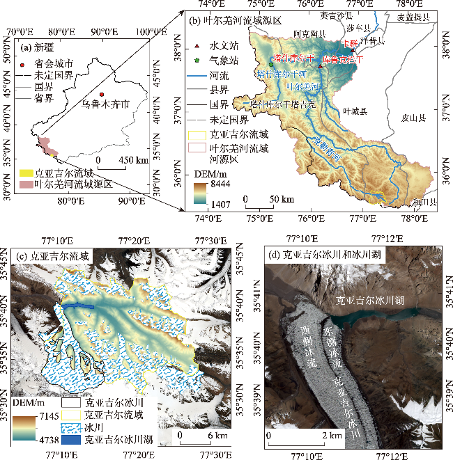
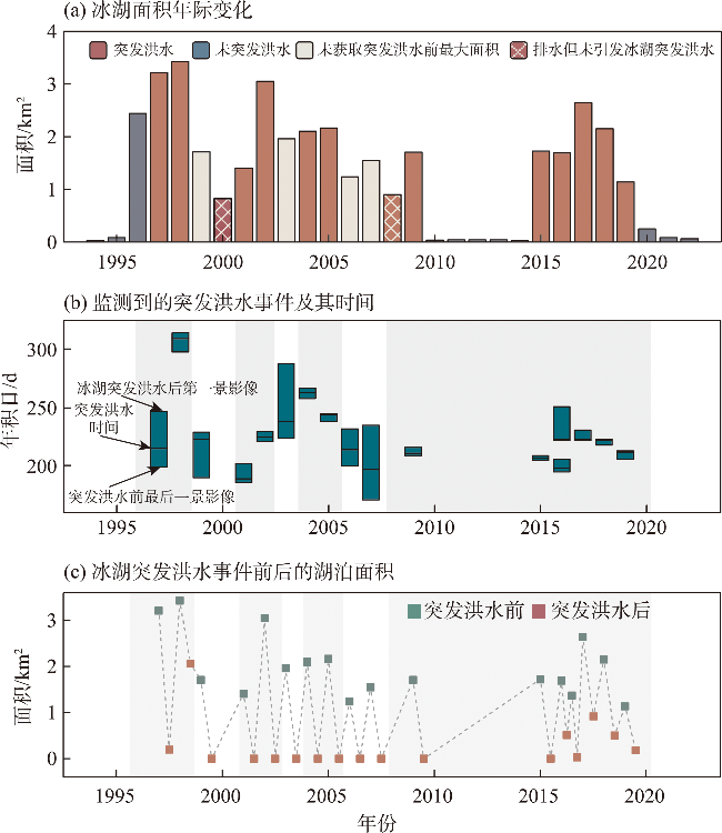
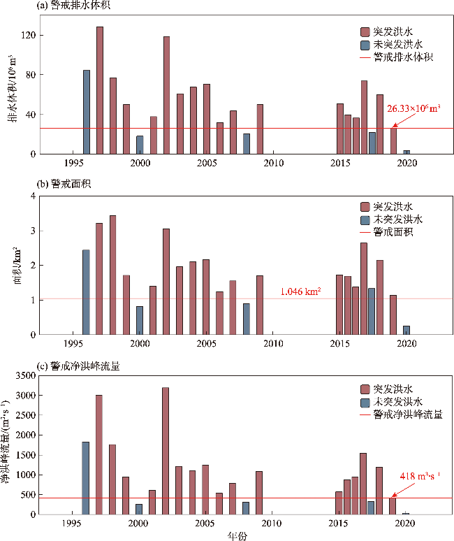
The periodic outburst floods from the Kyagar Glacier-dammed Lake pose a severe threat to downstream areas. In the context of global warming, research on monitoring and early warning for the Kyagar Glacier-dammed Lake is particularly important. Therefore, this study aimed to determine the alert area for the Kyagar Glacier-dammed Lake outburst floods. The area changes and sudden drainage events of the lake were first analyzed using multi-source optical remote sensing data from 1990-2023. Then, the critical minimum drainage volume of the lake was calculated using an area-volume empirical formula and historical flood data. At the same time, the rationality of the alert area was verified through the relationship between the drainage volume and the net flood peak discharge established in this study. The results showed that the lake experienced 20 sudden drainage events over the past 34 years, 17 of which led to glacial lake outburst floods. The periods 1996-2009 and 2015-2019 were unstable, with repeated lake filling and draining. The alert area for the outburst floods of the Kyagar Glacier-dammed Lake is 1.046 km2, and the alert net flood peak discharge resulting from the sudden drainage is 418 m3·s-1. Although the lake area shows a decreasing trend, the risk of flood disasters triggered by the Kyagar Glacier-dammed Lake outburst floods does not necessarily decrease. The lake outburst flood, when superimposed on high basic runoff, can still threaten downstream areas. When the lake area approaches its alert area, it is necessary to monitor its changes closely and implement early warning measures in combination with the basic runoff at the hydrological station. The proposed alert lake area and its determination method may provide scientific support for early warning monitoring of the outburst flood of the Kyagar Glacier-dammed Lake and offer guidance for early warning of flood disasters in the Yarkand River Basin.
LUO Xi , Alimujiang KASIMU , LIU Ying , BAO Anming , YUAN Ye , YU Tao . Research on the alert area of Kyagar Glacier-dammed Lake outburst floods in the Karakoram Mountains[J]. Arid Zone Research, 2025 , 42(4) : 622 -636 . DOI: 10.13866/j.azr.2025.04.05
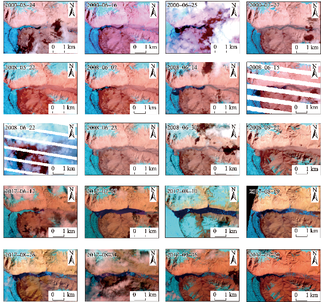
表1 研究所用影像数据Tab. 1 Data used in this study |
| 年份 | 数据集/传感器 | 影像日期/年-月-日 | 分辨率/m | 年份 | 数据集/传感器 | 影像日期/年-月-日 | 分辨率/m |
|---|---|---|---|---|---|---|---|
| 1990年 | Landsat-5 TM | 1990-03-09 | 30 | 2008年 | Landsat-5 TM | 2008-06-14 | 30 |
| 1991年 | Landsat-5 TM | 1991-07-02 | 30 | 2009年 | Landsat-7 EMT+ | 2009-07-27 | 30 |
| 1992年 | Landsat-5 TM | 1992-07-29 | 30 | Landsat-5 TM | 2009-07-28 | 30 | |
| 1993年 | Landsat-5 TM | 1993-07-07 | 30 | 2010年 | Landsat-5 TM | 2010-08-23 | 30 |
| 1994年 | Landsat-5 TM | 1994-08-27 | 30 | 2011年 | Landsat-5 TM | 2011-08-10 | 30 |
| 1995年 | Landsat-5 TM | 1995-01-18 | 30 | 2012年 | Landsat-7 EMT+ | 2012-08-20 | 30 |
| 1996年 | Landsat-5 TM | 1996-09-01 | 30 | 2013年 | Landsat-8 OLI | 2013-07-30 | 30 |
| 1997年 | Landsat-5 TM | 1997-07-18 | 30 | 2014年 | Landsat-8 OLI | 2014-07-01 | 30 |
| 1998年 | Landsat-5 TM | 1998-10-09 | 30 | 2015年 | GF-1 WFV2 | 2015-07-24 | 16 |
| Landsat-5 TM | 1998-10-25 | 30 | 2016年 | Landsat-7 EMT+ | 2016-07-14 | 30 | |
| Landsat-5 TM | 1998-11-03 | 30 | Landsat-7 EMT+ | 2016-07-30 | 30 | ||
| 1999年 | Landsat-7 EMT+ | 1999-07-09 | 30 | HJ1A CCD1 | 2016-08-02 | 30 | |
| 2000年 | Landsat-7 EMT+ | 2000-06-25 | 30 | HJ1A CCD1 | 2016-08-10 | 30 | |
| Landsat-7 EMT+ | 2000-07-27 | 30 | 2017年 | Landsat-8 OLI | 2017-08-10 | 30 | |
| 2001年 | Landsat-7 EMT+ | 2001-07-05 | 30 | Sentinel-2A/B MSI | 2017-08-31 | 10 | |
| 2002年 | Landsat-7 EMT+ | 2002-08-09 | 30 | 2018年 | Sentinel-2A/B MSI | 2018-08-06 | 10 |
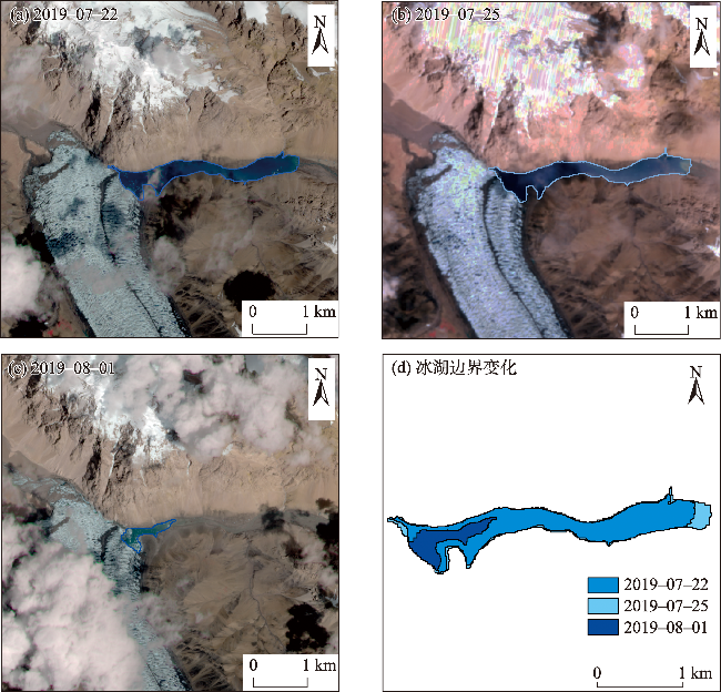
| 2003年 | Landsat-7 EMT+ | 2003-08-12 | 30 | 2019年 | GF-6 WFV | 2019-07-25 | 16 |
| 2004年 | Landsat-7 EMT+ | 2004-09-15 | 30 | 2020年 | Sentinel-2A/B MSI | 2020-06-06 | 10 |
| 2005年 | Landsat-7 EMT+ | 2005-08-26 | 30 | 2021年 | Sentinel-2A/B MSI | 2021-07-16 | 10 |
| 2006年 | Landsat-7 EMT+ | 2006-07-19 | 30 | 2022年 | Sentinel-2A/B MSI | 2022-06-26 | 10 |
| 2007年 | Landsat-7 EMT+ | 2007-06-20 | 30 | 2023年 | Sentinel-2A/B MSI | 2023-08-30 | 10 |
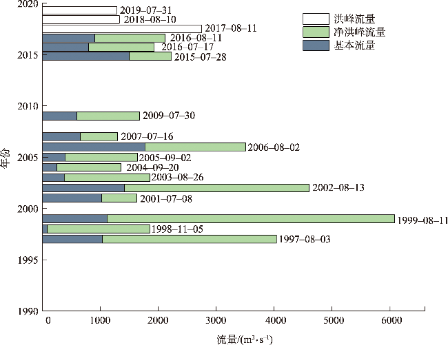
图2 1990—2023年卡群站克亚吉尔冰湖突发洪水洪峰流量Fig. 2 Peak discharge of Kyagar Glacial Lake outburst floods from 1990 to 2023 at Kaqun Station |
表2 1990—2023年克亚吉尔冰湖突发洪水事件Tab. 2 The Kyagar Glacial Lake outburst floods from 1990 to 2023 |
| 序号 | 年份 | 水文站 | 洪峰流量/(m3·s-1) | 基本流量/(m3·s-1) | 净洪峰流量/(m3·s-1) | 发生日期/月-日 | 文献来源 |
|---|---|---|---|---|---|---|---|
| 1 | 1997年 | 卡群站 | 4040 | 1033 | 3007 | 08-03 | [33] |
| 2 | 1998年 | 卡群站 | 1850 | 88 | 1762 | 11-05 | [33] |
| 3 | 1999年 | 卡群站 | 6070 | 1113 | 4967 | 08-11 | [33] |
| 4 | 2001年 | 卡群站 | 1630 | 1026 | 604 | 07-08 | [33] |
| 5 | 2002年 | 卡群站 | 4610 | 1420 | 3190 | 08-13 | [33] |
| 6 | 2003年 | 卡群站 | 1860 | 377 | 1483 | 08-26 | [33] |
| 7 | 2004年 | 卡群站 | 1360 | 253 | 1107 | 09-20 | [33] |
| 8 | 2005年 | 卡群站 | 1640 | 396 | 1244 | 09-02 | [33] |
| 9 | 2006年 | 卡群站 | 3510 | 1768 | 1742 | 08-02 | [33] |
| 10 | 2007年 | 卡群站 | 1300 | 654 | 646 | 07-16 | [33] |
| 11 | 2009年 | 卡群站 | 1680 | 595 | 1085 | 07-30 | [33] |
| 12 | 2015年 | 库鲁克栏杆站 | 2230 | 1500 | 730 | 07-28 | [17] |
| 13 | 2016年 | 库鲁克栏杆站 | 1930 | 798 | 1132 | 07-17 | [17] |
| 14 | 库鲁克栏杆站 | 2120 | 900 | 1220 | 08-11 | [17] | |
| 15 | 2017年 | 库鲁克栏杆站 | 2753 | - | - | 08-11 | [16] |
| 16 | 2018年 | 卡群站 | 1330 | - | - | 08-10 | [32] |
| 17 | 2019年 | 卡群站 | 1290 | - | - | 07-31 | [32] |
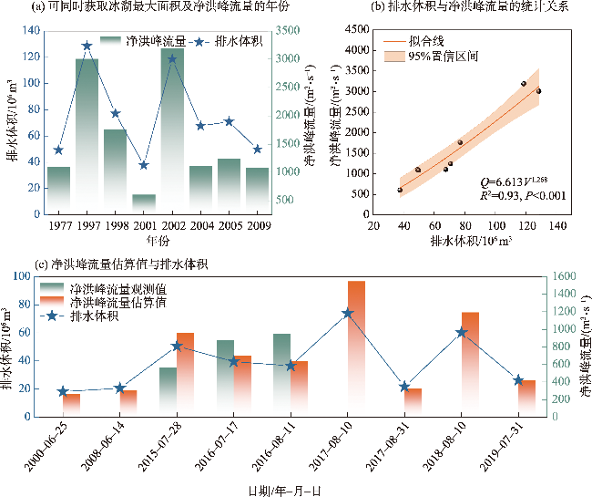
表3 冰湖突发洪水净洪峰流量估算及相对误差Tab. 3 Estimations of net peak discharge and relative error of glacial lake outburst floods |
| 日期/年-月-日 | 湖泊面积/km2 | 未完全排水剩余 湖泊面积/km2 | 排水体积 /106 m3 | 净洪峰流量估算值 /(m3·s-1) | 净洪峰流量观测值 /(m3·s-1) | 相对误差/% |
|---|---|---|---|---|---|---|
| 2015-07-28 | 1.72 | 50.61 | 958 | 569 | 68.39 | |
| 2016-07-17 | 1.69 | 0.51 | 39.54 | 701 | 876 | -20.00 |
| 2016-08-11 | 1.37 | 36.6 | 635 | 948 | -33.04 | |
| 2018-08-10 | 2.15 | 0.51 | 60.17 | 1193 | 316~716 | - |
| 2019-07-31 | 1.14 | 0.18 | 26.33 | 418 | 217~617 | - |
| 2000-06-25 | 0.82 | 18.2 | 262 | - | - | |
| 2008-06-14 | 0.90 | 20.62 | 307 | - | - | |
| 2017-08-10 | 2.64 | 0.92 | 73.8 | 1546 | - | - |
| 2017-08-31 | 1.33 | 0.65 | 21.75 | 328 | - | - |
图7 克亚吉尔冰川阻塞湖警戒排水体积、警戒面积及警戒净洪峰流量Fig. 7 The alert drainage volume, alert area, and alert net peak discharge of the Kyagar Glacier-dammed Lake |
| [1] |
|
| [2] |
|
| [3] |
|
| [4] |
|
| [5] |
|
| [6] |
张祥松, 周聿超. 喀喇昆仑山叶尔羌河冰川湖突发洪水研究[M]. 北京: 科学出版社, 1990.
[
|
| [7] |
张祥松, 李念杰, 由希尧, 等. 新疆叶尔羌河冰川湖突发洪水研究[J]. 中国科学(B辑化学生命科学地学), 1989, 40(11): 1197-1204, 1233-1234.
[
|
| [8] |
|
| [9] |
|
| [10] |
丁辉, 蔡向辉. 新疆叶尔羌河洪水发生规律分析[J]. 中国防汛抗旱, 2011, 94(1): 35-36, 43.
[
|
| [11] |
袁波波, 彭亮, 姜卉芳. 叶尔羌河冰湖溃坝洪水早期预警系统参数的确定方法[J]. 水资源与水工程学报, 2014, 25(6): 82-85.
[
|
| [12] |
敖志刚, 丁辉. 中瑞叶尔羌河冰川湖洪水监测预警项目管理经验浅析[J]. 科技传播, 2014, 6(5): 166, 149.
[
|
| [13] |
彭亮, 敖志刚, 陈建江, 等. 喀喇昆仑山克亚吉尔冰川湖监测预警设计与应用[J]. 水资源与水工程学报, 2014, 25(5): 124-126, 131.
[
|
| [14] |
|
| [15] |
袁波波. 叶尔羌河冰川湖溃决洪水监测预警研究[D]. 乌鲁木齐: 新疆农业大学, 2015.
[
|
| [16] |
蒋紫云. 气候变化背景下克亚吉尔冰川运动对冰湖变化的影响研究[D]. 信阳: 信阳师范学院, 2023.
[
|
| [17] |
|
| [18] |
|
| [19] |
姚晓军, 刘时银, 魏俊锋. 喜马拉雅山北坡冰碛湖库容计算及变化——以龙巴萨巴湖为例[J]. 地理学报, 2010, 65(11): 1381-1390.
[
|
| [20] |
车涛, 晋锐, 李新, 等. 近20 a来西藏朋曲流域冰湖变化及潜在溃决冰湖分析[J]. 冰川冻土, 2004, 26(4): 397-402.
[
|
| [21] |
汪宙峰, 贺相綦, 王成武. 基于地理探测器与SVM的冰湖溃决预测研究——以喜马拉雅山地区为例[J]. 自然灾害学报, 2022, 31(6): 220-228.
[
|
| [22] |
吴坤鹏. 天山冰湖变化及其影响研究[D]. 湘潭: 湖南科技大学, 2015.
[
|
| [23] |
|
| [24] |
李治国, 姚檀栋, 叶庆华, 等. 1980—2007年喜马拉雅东段洛扎地区冰湖变化遥感研究[J]. 自然资源学报, 2011, 26(5): 836-846.
[
|
| [25] |
|
| [26] |
|
| [27] |
王杰, 马英杰. 新疆叶尔羌河溃坝洪水分析[J]. 中国水运(下半月), 2016, 16(6): 212-214.
[
|
| [28] |
|
| [29] |
李达, 上官冬辉, 黄维东. 1998—2017年天山麦兹巴赫冰川湖面积变化研究[J]. 冰川冻土, 2020, 42(4): 1126-1134.
[
|
| [30] |
郭万钦, 刘时银, 许君利, 等. 木孜塔格西北坡鱼鳞川冰川跃动遥感监测[J]. 冰川冻土, 2012, 34(4):765-774.
[
|
| [31] |
孙永玲, 江利明, 柳林, 等. 基于Landsat-7 ETM+SLC-OFF影像的山地冰川流速提取与评估——以Karakoram锡亚琴冰川为例[J]. 冰川冻土, 2016, 38(3): 596-603.
[
|
| [32] |
努尔比亚·吐尼牙孜, 米日古丽·米吉提, 毛炜峄, 等. 1961—2021年叶尔羌河流域克亚吉尔冰湖溃决洪水变化特征[J]. 冰川冻土, 2023, 45(4): 1288-1299.
[
|
| [33] |
王杰. 叶尔羌河冰川湖溃决洪水与融雪型洪水的分型及组合研究[D]. 乌鲁木齐: 新疆农业大学, 2018.
[
|
| [34] |
杨静. 叶尔羌河库鲁克栏杆站-喀群站洪水传播时间规律[J]. 吉林水利, 2014(7): 57-59.
[
|
| [35] |
孙步伟, 赵萍, 程雷, 等. 基于Munsell HSV变换的 TM 影像水体提取方法研究[J]. 遥感技术与应用, 2009, 24(6): 797-800.
[
|
| [36] |
|
| [37] |
|
| [38] |
刘军彦, 王世杰. 基于ICESat-2卫星测高数据的呼伦湖水位变化监测[J]. 干旱区研究, 2023, 40(9): 1438-1445.
[
|
| [39] |
马云飞. 叶尔羌河冰川湖突发洪水变化特征及防御研究[D]. 乌鲁木齐: 新疆农业大学, 2022.
[
|
| [40] |
牛竞飞, 刘景时, 王迪, 等. 2009年喀喇昆仑山叶尔羌河冰川阻塞湖及冰川跃动监测[J]. 山地学报, 2011, 29(3): 276-282.
[
|
| [41] |
|
/
| 〈 |
|
〉 |