
Identification and optimization strategy of an ecological network in Inner Mongolia based on “service importance-habitat sensitivity-biodiversity”
Received date: 2023-12-29
Revised date: 2024-03-23
Online published: 2025-08-14
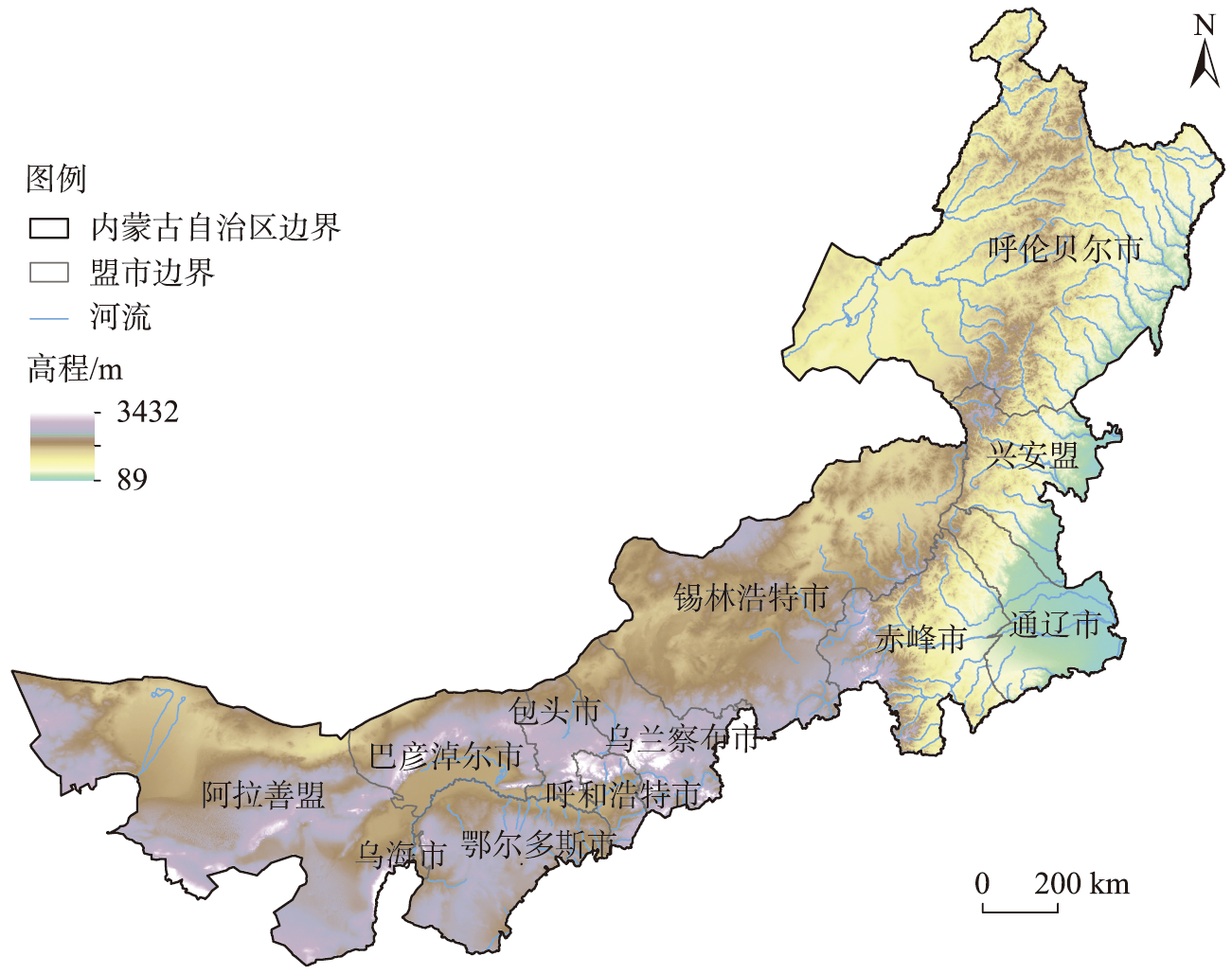
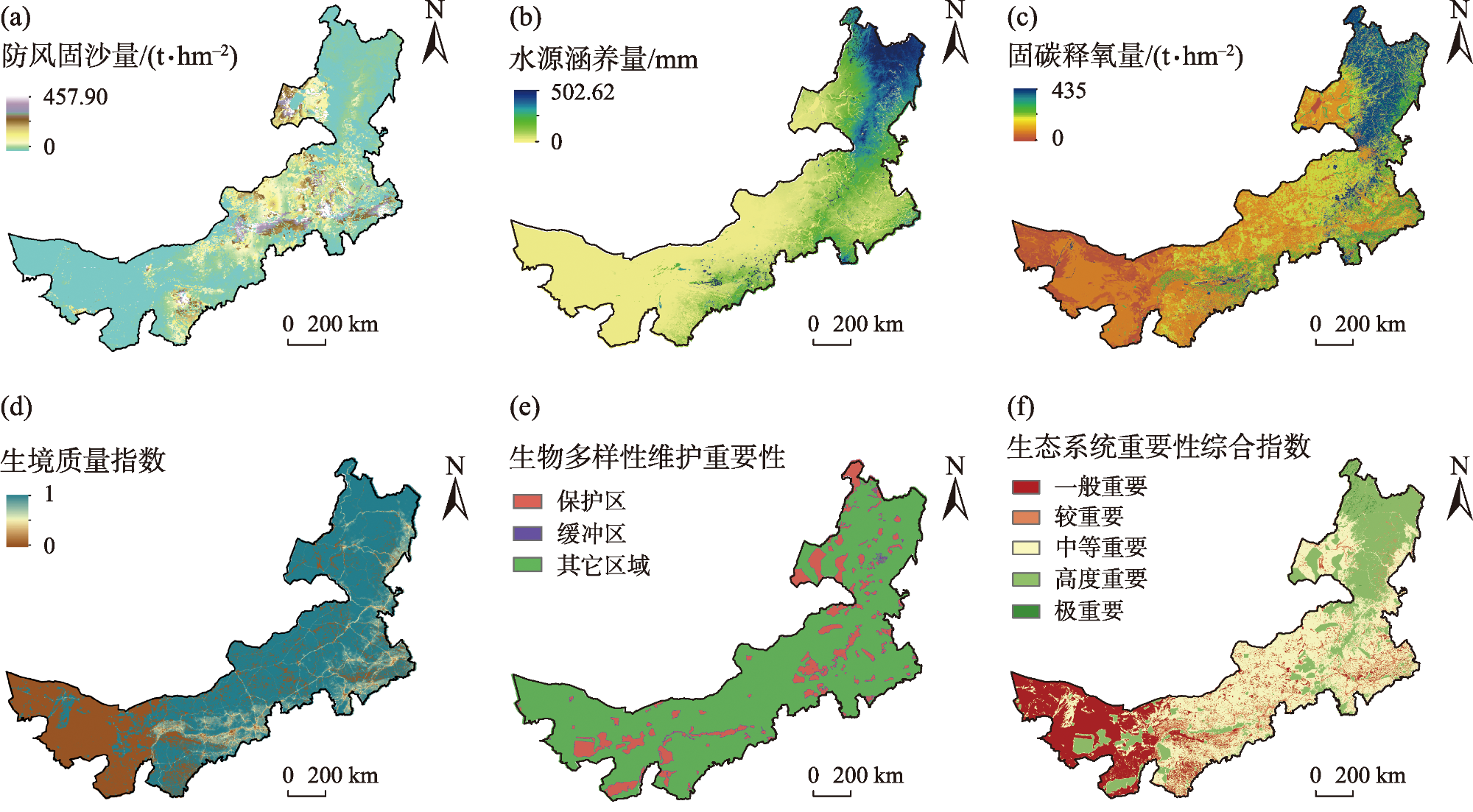
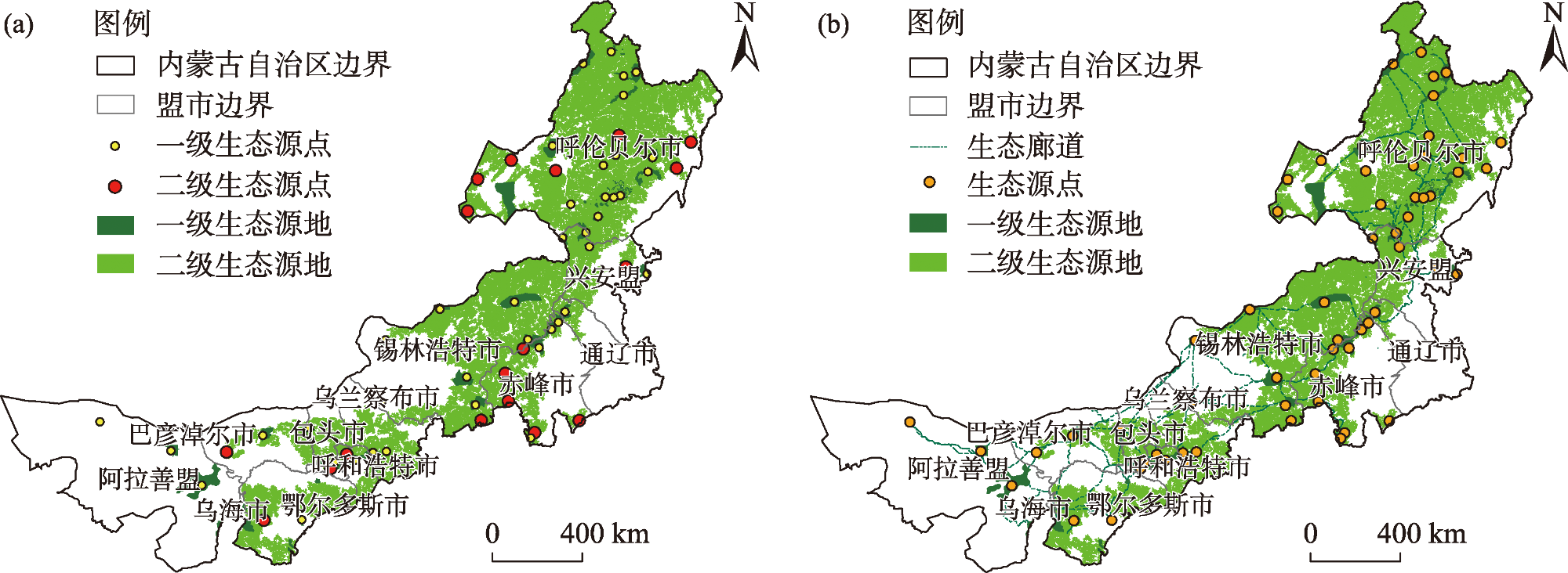
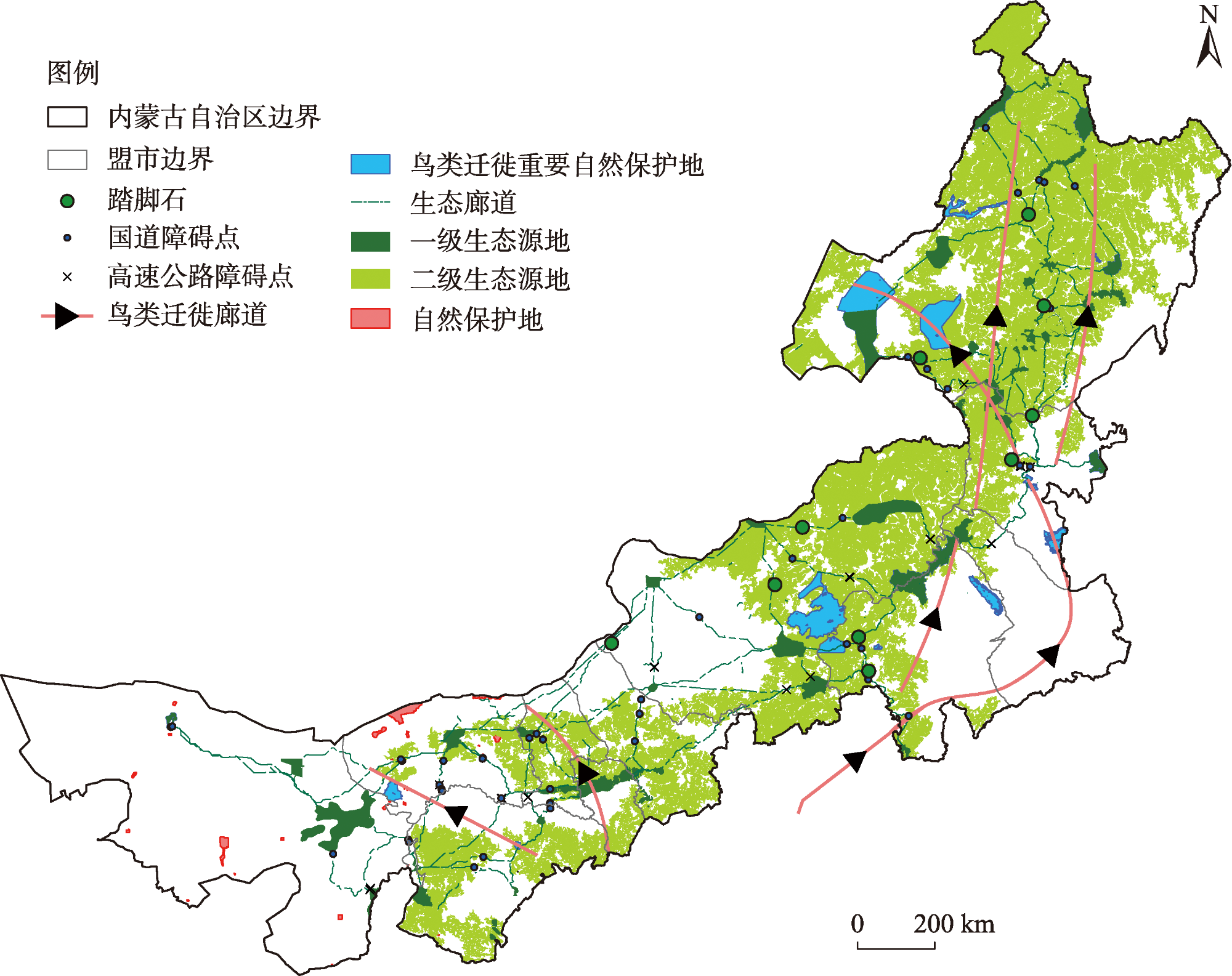
The identification of ecological spatial quality and the construction of regional conservation networks are of great significance for optimizing habitat layout, improving ecological carrying capacity, and maintaining ecosystem stability. Taking the Inner Mongolia Autonomous Region as an example, this study constructed a conservation network identification framework of “service importance-habitat sensitivity-biodiversity” and identified ecological source areas by evaluating the ecosystem service importance and habitat sensitivity. Based on these findings, the study, coupled with the existing nature reserve system, utilized the Least Cumulative Resistance model to identify important ecological corridors and construct a conservation network in the Inner Mongolia Autonomous Region. The ecological stepping stones and obstacle points to be optimized were extracted by analyzing the spatial superposition relationship between ecological corridors and infrastructure. The results show that (1) the area of Class I ecological source sites in the region was 3.80×10⁴ km2, accounting for 3.21% of the total study area, with a high degree of overlap with the red line of ecological protection. (2) A total of 84 potential ecological corridors were identified based on nature reserves and Class I ecological source sites, with a total length of 15910 km, and a combination of ecological source sites, potential corridors, and bird migratory corridors was used to construct the Inner Mongolia conservation network. (3) In total, five bird migration corridors, ten stepping-stone-quality habitat construction sites, and 81 ecological barrier repair sites were identified. These results can provide data support and location reference for the management and construction of species migration and energy flow networks in ecological protection and restoration projects in the Inner Mongolia Autonomous Region.
LIU Xin , WANG Liqun , LI Haoran , LI Yonghong , QIAO Wenguang , LI Lijuan , WANG Chenxu . Identification and optimization strategy of an ecological network in Inner Mongolia based on “service importance-habitat sensitivity-biodiversity”[J]. Arid Zone Research, 2024 , 41(7) : 1207 -1216 . DOI: 10.13866/j.azr.2024.07.12
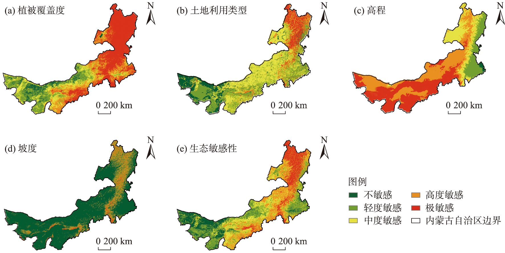
表1 生态敏感性指标体系Tab. 1 Index system of ecological sensitivity |
| 评价因子 | 敏感性赋值 | 权重 | ||||
|---|---|---|---|---|---|---|
| 1 | 3 | 5 | 7 | 9 | ||
| 土地利用类型 | 建设用地 | 耕地、沙地 | 草地 | 水体 | 林地 | 0.32 |
| 植被覆盖度 | <0.26 | 0.26~0.59 | 0.59~0.75 | 0.75~0.89 | >0.89 | 0.28 |
| 高程 | <150 | 150~500 | 500~800 | 800~1200 | >1200 | 0.2 |
| 坡度 | <2° | 2~5° | 5~8° | 8~15° | >15° | 0.2 |
| [1] |
李正, 赵林. 西北干旱区山水林田湖草沙系统治理研究实践——以塔里木河重要源流区为例[J]. 中国国土资源经济, 2022, 35(12): 13-18, 63.
[
|
| [2] |
王晨旭, 刘焱序, 于超月, 等. 国土空间生态修复布局研究进展[J]. 地理科学进展, 2021, 40(11): 1925-1941.
[
|
| [3] |
傅伯杰. 黄土高原土地利用变化的生态环境效应[J]. 科学通报, 2022, 67(32): 3768-3779.
[
|
| [4] |
|
| [5] |
|
| [6] |
卢洁, 焦胜, 胡加琦, 等. 基于多尺度协同的长沙市生态网络构建与层级优化[J]. 生态学报, 2023, 43(15): 6332-6344.
[
|
| [7] |
陈利顶, 周伟奇, 韩立建, 等. 京津冀城市群地区生态安全格局构建与保障对策[J]. 生态学报, 2016, 36(22): 7125-7129.
[
|
| [8] |
苏冲, 董建权, 马志刚, 等. 基于生态安全格局的山水林田湖草生态保护修复优先区识别——以四川省华蓥山区为例[J]. 生态学报, 2019, 39(23): 8948-8956.
[
|
| [9] |
李宗尧, 杨桂山, 董雅文. 经济快速发展地区生态安全格局的构建——以安徽沿江地区为例[J]. 自然资源学报, 2007, 22(1): 106-113.
[
|
| [10] |
于超月, 王晨旭, 冯喆, 等. 北京市生态安全格局保护紧迫性分级[J]. 北京大学学报(自然科学版), 2020, 56(6): 1047-1055.
[
|
| [11] |
|
| [12] |
彭建, 赵会娟, 刘焱序, 等. 区域生态安全格局构建研究进展与展望[J]. 地理研究, 2017, 36(3): 407-419.
[
|
| [13] |
秦富仓, 赵鹏武, 李龙, 等. “双碳”背景下提升内蒙古森林碳汇功能的思考[J]. 北方经济, 2023(2): 27-30.
[
|
| [14] |
刘哲荣, 刘果厚, 高润宏. 内蒙古珍稀濒危植物濒危现状及优先保护评估[J]. 应用生态学报, 2019, 30(6): 1974-1982.
[
|
| [15] |
姜洋. 水鸟迁徙路线与保护[J]. 黑龙江科学, 2017, 8(12): 7.
[
|
| [16] |
曹垒, 孟凡娟, 赵青山. 基于前沿监测技术探讨“大开发”对鸟类迁徙及其栖息地的影响[J]. 中国科学院院刊, 2021, 36(4): 436-447.
[
|
| [17] |
|
| [18] |
冯琰玮, 甄江红, 马晨阳. 内蒙古生态承载力评价及生态安全格局优化[J]. 地理研究, 2021, 40(4): 1096-1110.
[
|
| [19] |
王良杰, 马帅, 许稼昌, 等. 基于生态系统服务权衡的优先保护区选取研究——以南方丘陵山地带为例[J]. 生态学报, 2021, 41(5): 1716-1727.
[
|
| [20] |
王燕, 高吉喜, 金宇, 等. 基于2005—2015年土地利用变化和InVEST模型的内蒙古巴林右旗农牧交错带生境质量研究[J]. 生态与农村环境学报, 2020, 36(5): 654-662.
[
|
| [21] |
陈瑶瑶, 罗志军, 齐松, 等. 基于生态敏感性与生态网络的南昌市生态安全格局构建[J]. 水土保持研究, 2021, 28(4): 342-349.
[
|
| [22] |
刘海龙, 王炜桥, 王跃飞, 等. 汾河流域生态敏感性综合评价及时空演变特征[J]. 生态学报, 2021, 41(10): 3952-3964.
[
|
| [23] |
吴茂全, 胡蒙蒙, 汪涛, 等. 基于生态安全格局与多尺度景观连通性的城市生态源地识别[J]. 生态学报, 2019, 39(13): 4720-4731.
[
|
| [24] |
林斐菲, 谢苗苗, 张昊, 等. 基于MSPA的内蒙古生态用地及其连通性时空动态[J]. 湖北农业科学, 2021, 60(12): 55-62.
[
|
| [25] |
杨凯, 曹银贵, 冯喆, 等. 基于最小累积阻力模型的生态安全格局构建研究进展[J]. 生态与农村环境学报, 2021, 37(5): 555-565.
[
|
| [26] |
孔颖. 我国鸟类迁徙路线上的湿地资源现状及保护对策[J]. 环境与发展, 2020, 32(3): 201-202, 207.
[
|
| [27] |
史瑶. 基于MSPA和MCR模型的资兴市生态网络构建研究[D]. 中南林业科技大学, 2019.
[
|
| [28] |
|
| [29] |
|
| [30] |
毛诚瑞, 代力民, 齐麟, 等. 基于生态系统服务的流域生态安全格局构建——以辽宁省辽河流域为例[J]. 生态学报, 2020, 40(18): 6486-6494.
[
|
| [31] |
韦家怡, 李铖, 吴志峰, 等. 粤港澳大湾区生态安全格局及重要生态廊道识别[J]. 生态环境学报, 2022, 31(4): 652-662.
[
|
| [32] |
|
/
| 〈 |
|
〉 |