
Effect of the Hotan River on the spatial pattern of surrounding eolian landforms in Xinjiang
Received date: 2024-11-07
Revised date: 2024-11-26
Online published: 2025-08-13
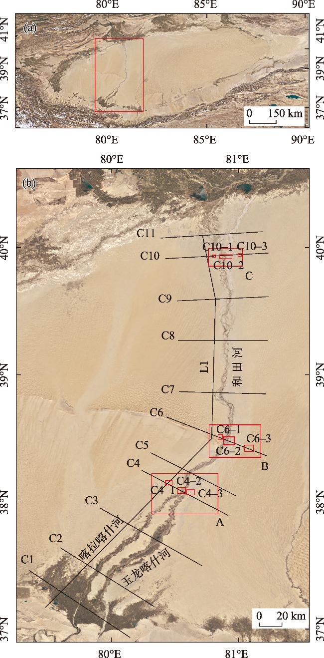
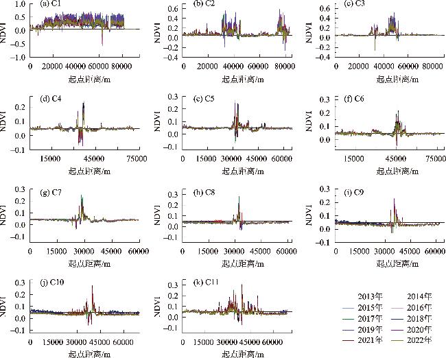
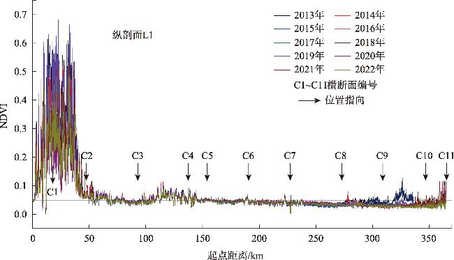
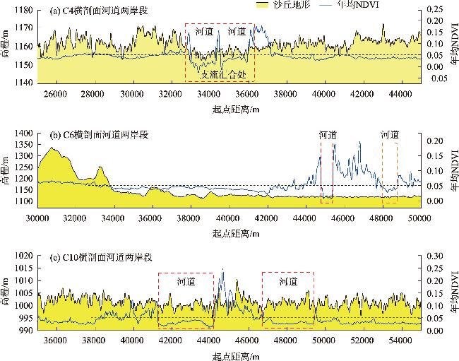
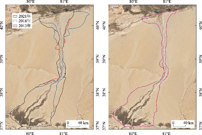
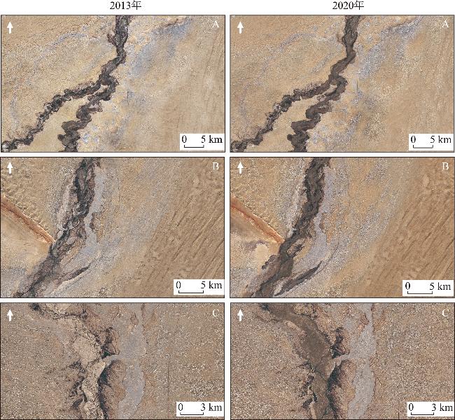
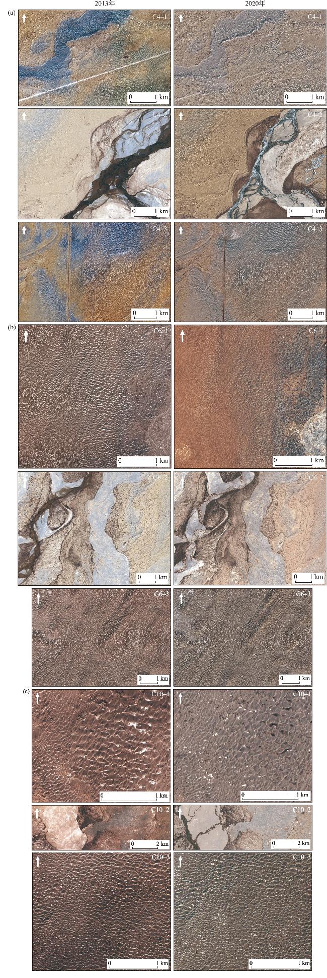
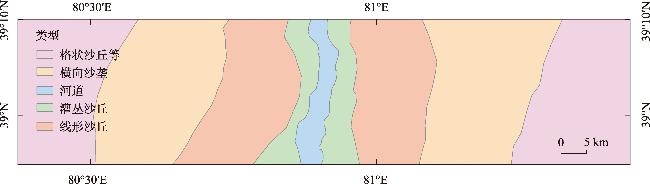
The interaction between wind and water is key in shaping the morphology and spatial distribution of eolian landforms. Quantifying the influence of rivers on eolian landforms has always been challenging. This work selected the Hotan River, which crosses the Taklamakan Desert and the surrounding eolian landforms, as the research object. Based on high-resolution remote-sensing images, DEM and NDVI data, comparing relevant characteristic parameters of typical cross-sections, and analyzing the pattern of eolian landforms and the changes in river channel morphological parameters, the following results were obtained. (1) In the intersection area of the Hotan River and eolian landforms, NDVI=0.05 can be used as a critical value to distinguish the influence of rivers on the pattern of eolian landforms. Consequently, the spatial distribution of the area affected by the Hotan River on eolian landforms is revealed: its area is 20700 km2 and its width ranges from 6 to 121 km. (2) The channel morphology of the Hotan River changes little, making it difficult to cause long-distance lateral migration of the river channel; the impact area on the surrounding eolian landforms will not change significantly. In the process of the interaction between wind and water, the Hotan River plays a leading role. Moreover, the southern section belongs to the fully fluvial dominant type, while the northern section belongs to the mostly fluvial dominant type. (3) The distribution pattern of eolian landforms that can be recognized as sabkhas, longitudinal dunes, transverse ridges, and reticulate dunes in sequence from the river channel to both sides results from long-term interactions between wind and water.
WANG Xumin , GAO Xin , HU Zihao , ZHOU Jie . Effect of the Hotan River on the spatial pattern of surrounding eolian landforms in Xinjiang[J]. Arid Zone Research, 2025 , 42(2) : 333 -348 . DOI: 10.13866/j.azr.2025.02.13
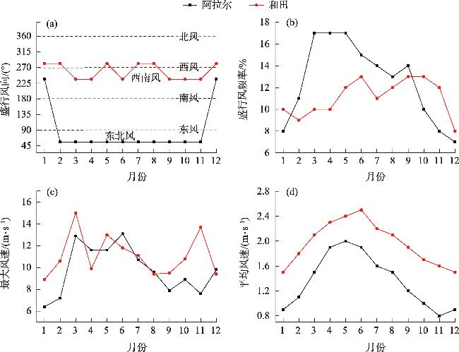
表1 和田河周边主要气象站1991—2020年的平均风况特征Tab. 1 Characteristics of the average wind conditions of the main meteorological stations around the Hotan River from 1991 to 2020 |
| 位置 | 站点 | 最大风速/(m·s-1) | 平均风速/(m·s-1) | 盛行风向代号 | 盛行风向/(°) | 盛行风向频率/% |
|---|---|---|---|---|---|---|
| 北部 | 阿克苏 | 18.5 | 1.7 | 2 | 11.25~33.75 | 10 |
| 阿拉尔 | 13.1 | 1.4 | 3 | 33.75~56.25 | 13 | |
| 东部 | 策勒 | 10.0 | 1.3 | 13 | 258.75~281.25 | 12 |
| 于田 | 14.0 | 1.2 | 13 | 258.75~281.25 | 8 | |
| 民丰 | 16.0 | 1.6 | 3 | 33.75~56.25 | 12 | |
| 塔中 | 20.0 | 2.2 | 4 | 56.25~78.75 | 13 | |
| 南部 | 墨玉 | 11.7 | 1.3 | 15 | 303.75~326.25 | 7 |
| 和田 | 15.0 | 2.0 | 11 | 213.75~236.25 | 11 | |
| 洛浦 | 13.6 | 1.7 | 13 | 258.75~281.25 | 10 | |
| 西部 | 麦盖提 | 12.5 | 1.3 | 3 | 33.75~56.25 | 8 |
| 莎车 | 12.0 | 1.3 | 15 | 303.75~326.25 | 10 | |
| 皮山 | 13.5 | 1.5 | 15 | 303.75~326.25 | 10 |
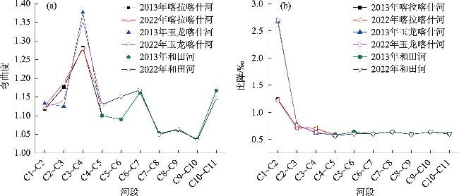
图9 和田河不同河段的河道弯曲度和河道比降变化特征Fig. 9 Characteristics of channel sinuosity and gradient in different sections of the Hotan River |
表2 和田河及其支流河道的弯曲度和比降的时空变化Tab. 2 Spatiotemporal variations of channel sinuosity and gradient of the Hotan River and its tributaries |
| 河流 | 河段 | 河道弯曲度 | 弯曲度 变化率/% | 河道比降/‰ | 比降 变化率/% | ||
|---|---|---|---|---|---|---|---|
| 2013年 | 2022年 | 2013年 | 2022年 | ||||
| 喀拉喀什河 | C1~C2 | 1.117 | 1.126 | 0.81 | 1.234 | 1.223 | -0.89 |
| C2~C3 | 1.177 | 1.188 | 0.93 | 0.721 | 0.715 | -0.83 | |
| C3~C4 | 1.283 | 1.279 | -0.31 | 0.699 | 0.701 | 0.29 | |
| 玉龙喀什河 | C1~C2 | 1.133 | 1.121 | -1.06 | 2.664 | 2.694 | 1.13 |
| C2~C3 | 1.125 | 1.140 | 1.33 | 0.769 | 0.759 | -1.30 | |
| C3~C4 | 1.377 | 1.354 | -1.67 | 0.619 | 0.630 | 1.78 | |
| 和田河 | C4~C5 | 1.100 | 1.129 | 2.64 | 0.581 | 0.567 | -2.41 |
| C5~C6 | 1.090 | 1.151 | 5.60 | 0.639 | 0.605 | -5.32 | |
| C6~C7 | 1.162 | 1.169 | 0.60 | 0.605 | 0.602 | -0.50 | |
| C7~C8 | 1.054 | 1.049 | -0.47 | 0.640 | 0.643 | 0.47 | |
| C8~C9 | 1.061 | 1.065 | 0.38 | 0.594 | 0.592 | -0.34 | |
| C9~C10 | 1.037 | 1.034 | -0.29 | 0.639 | 0.640 | 0.16 | |
| C10~C11 | 1.167 | 1.147 | -1.71 | 0.600 | 0.610 | 1.67 | |
研究工作得到有关老师的指导和同学的帮助,在此表示衷心感谢!
| [1] |
吴正. 风沙地貌与治沙工程学[M]. 北京: 科学出版社, 2003.
[
|
| [2] |
|
| [3] |
|
| [4] |
|
| [5] |
|
| [6] |
宋阳, 刘连友, 严平. 风水复合侵蚀研究述评[J]. 地理学报, 2006, 61(1): 77-88.
[
|
| [7] |
|
| [8] |
|
| [9] |
|
| [10] |
|
| [11] |
|
| [12] |
李永山, 彭文昌, 任亮, 等. 近50年黄河乌兰布和沙漠段辫状河道演变[J]. 中国沙漠, 2016, 36(6): 1689-1694.
[
|
| [13] |
|
| [14] |
|
| [15] |
|
| [16] |
|
| [17] |
|
| [18] |
李小妹, 严平. 中国北方地区沙漠与河流景观格局[J]. 地理科学进展, 2014, 33(9): 1198-1208.
[
|
| [19] |
朱震达, 陈治平, 吴正, 等. 塔克拉玛干沙漠风沙地貌研究[M]. 北京: 科学出版社, 1981.
[
|
| [20] |
朱震达, 吴正, 李钜章, 等. 塔克拉玛干沙漠风沙地貌研究[J]. 科学通报, 1966(13): 620-624.
[
|
| [21] |
|
| [22] |
|
| [23] |
肖方, 李肖, 李承森, 等. 认识塔克拉玛干沙漠[J]. 生命世界, 2019(2): 52-53.
[
|
| [24] |
|
| [25] |
|
| [26] |
余其鹰, 白云岗, 张江辉, 等. 和田河流域干流河道耗水过程分析[J]. 水资源与水工程学报, 2021, 32(2): 73-79.
[
|
| [27] |
韩兴胜, 陈雄波. 和田河河道冲淤特性分析[J]. 人民黄河, 2024, 46(S1): 26-28.
[
|
| [28] |
黄领梅, 沈冰. 和田河汇入塔里木河径流演变及成因分析[J]. 水资源与水工程学报, 2012, 23(2): 26-28.
[
|
| [29] |
李卫红, 黎枫, 陈忠升, 等. 和田河流域平原耗水驱动力与适宜绿洲规模分析[J]. 冰川冻土, 2011, 33(5): 1161-1168.
[
|
| [30] |
夏婷婷, 薛璇, 王灏伟, 等. 昆仑山北坡陆地水储量变化及其驱动因素分析[J]. 干旱区地理, 2024, 47(8): 1292-1303.
[
|
| [31] |
刘鑫, 高鑫. 塔克拉玛干沙漠南缘新月形沙丘移动特征[J]. 干旱区研究, 2024, 41(4): 661-673.
[
|
/
| 〈 |
|
〉 |