Weather and Climate

Characteristics and differences in heavy rainfall in the western and central sections of the northern slope of the Kunlun Mountains

  • YANG Xia , 1 ,
  • YANG Liu 2
Expand
  • 1. Xinjiang Uygur Autonomous Region Meteorological Observatory, Urumqi 830002, Xinjiang, China
  • 2. Bayingol Mongolian Autonomous Prefecture Meteorological Bureau, Korla 841000, Xinjiang, China

Received date: 2024-10-17

  Revised date: 2024-11-28

  Online published: 2025-08-13

Abstract

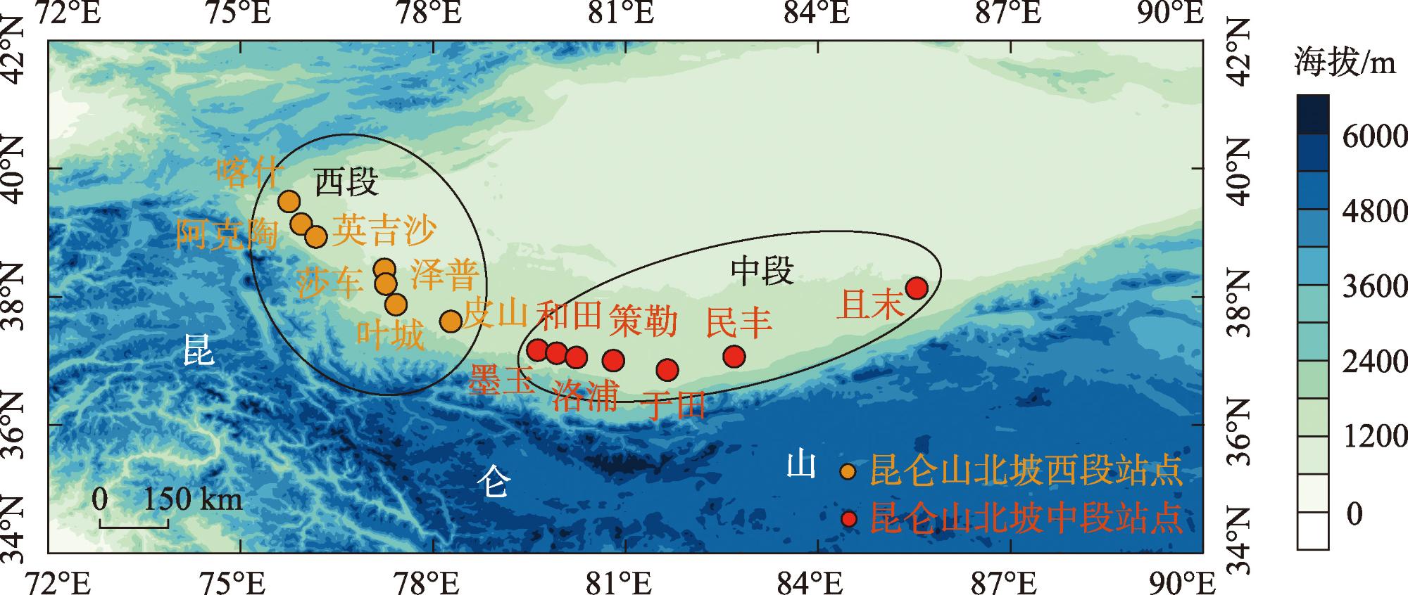
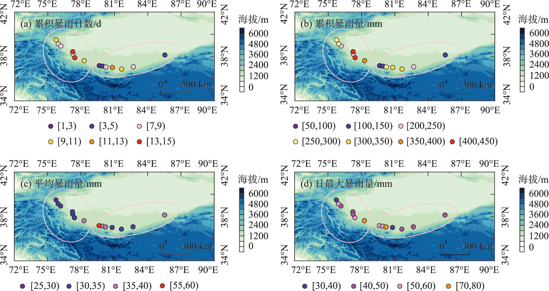
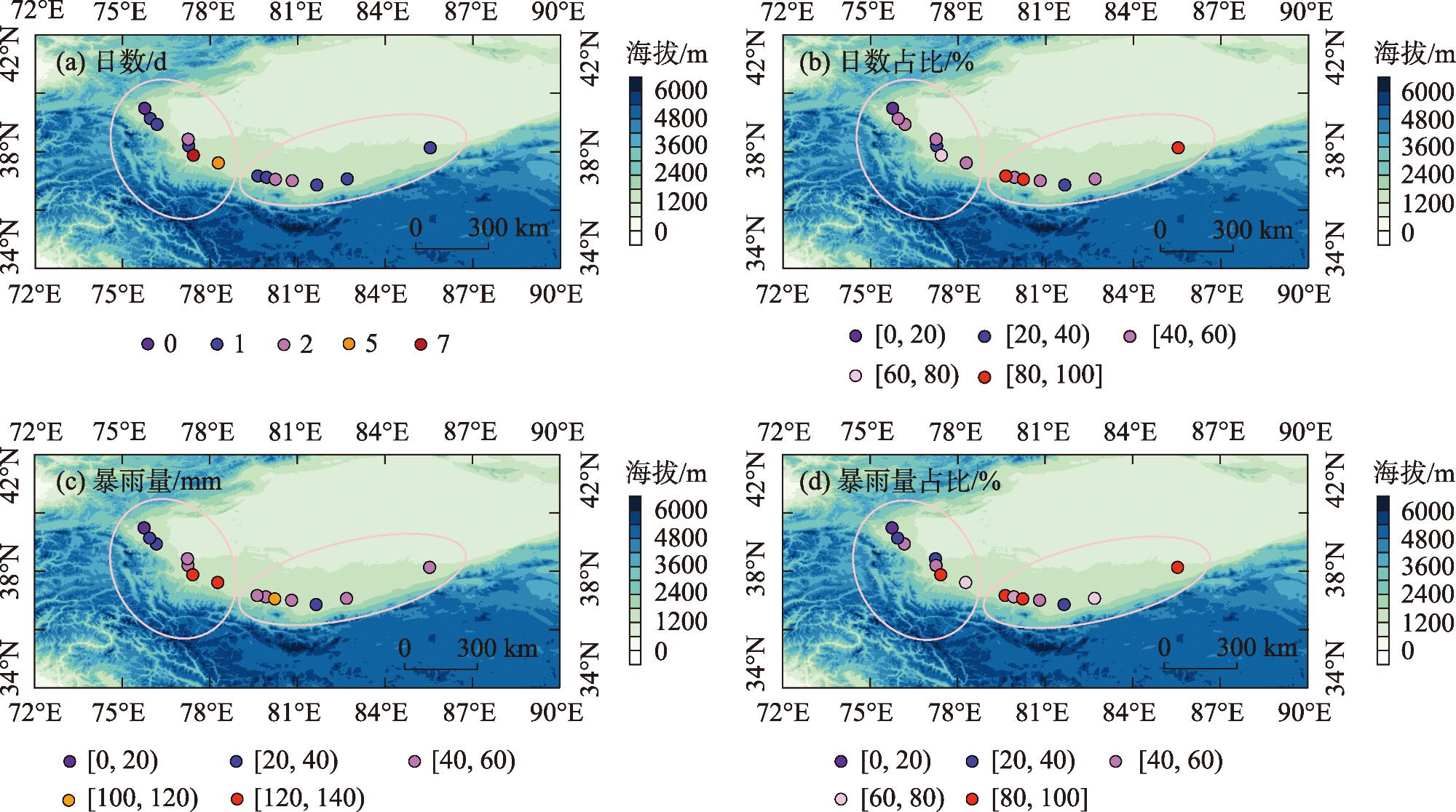
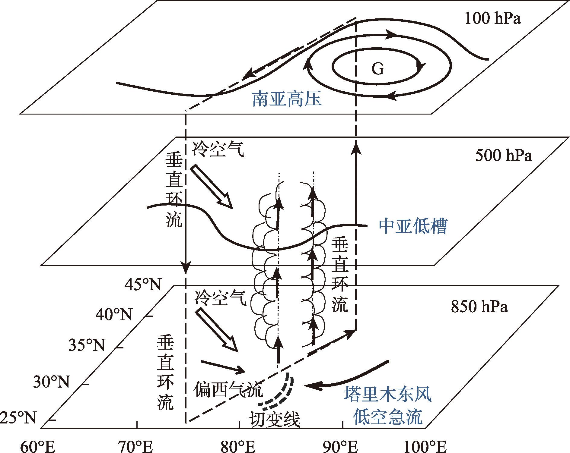
The north slope of the Kunlun Mountains is an essential corridor for the construction of the core area of the Silk Road Economic Belt. It is located in the inland arid zone of Northwest China, where torrential rains are sudden, short-lived, and disaster-heavy. In the actual forecasting operations, there are more empty reports and omissions of torrential rains in the north slope of the Kunlun Mountains, which leads to insufficient disaster defense in this region. This study used precipitation and reanalysis data from the national meteorological stations on the north slope of the Kunlun Mountains from 1961 to 2023 to reveal the characteristics of long-term changes in heavy rainfall in different regions of the north slope of the Kunlun Mountains and the differences in circulation. The results revealed that (1) from 1961 to 2023, the number of heavy rain days and the amount of heavy rainfall in the western and central sections of the northern slope of the Kunlun Mountains exhibited an increasing trend, with the western section exhibiting a more pronounced increase. The cumulative number of heavy rain days and heavy rainfall in the western section was greater than in the central section. However, the difference in extreme rainfall amounts between the two sections was not significant. In the western section, the amount of heavy rainfall during the warm and humid phase was greater than that during the warm and dry phase, while the opposite was observed for the central section, indicating different levels of response to climate transitions. (2) the spatial distribution of heavy rain days and heavy rainfall volumes on the western section of the northern slope exhibited a characteristic of “more in the east and less in the west,” while the central section displayed a pattern of “more in the middle and less on the sides.” The spatial distribution of average heavy rainfall and cumulative heavy rainfall volumes is consistent in the western section but opposite in the central section. (3) over 90.0% of the stations on the northern slope of the Kunlun Mountains have experienced short-duration heavy rainfall events, which is higher than the average for southern Xinjiang; nonshort-duration heavy rainfall events predominantly characterize the western section (central section). The persistence of heavy rainfall events on the northern slope is relatively poor, with a majority occurring at night, and the average precipitation duration of heavy rainfall events in the western and central sections is similar. (4) the typical configuration of the main weather systems causing heavy rainfall in the western and central sections of the northern slope is the same, which increases the difficulty of precise forecasting for the fine-scale distribution of heavy rainfall in the Kunlun Mountains. The research findings can deepen our understanding of the uniqueness of heavy rainfall in arid regions and provide references for enhancing the defense capabilities against heavy rainfall on the northern slope of the Kunlun Mountains.

Cite this article

YANG Xia , YANG Liu . Characteristics and differences in heavy rainfall in the western and central sections of the northern slope of the Kunlun Mountains[J]. Arid Zone Research, 2025 , 42(2) : 202 -211 . DOI: 10.13866/j.azr.2025.02.02
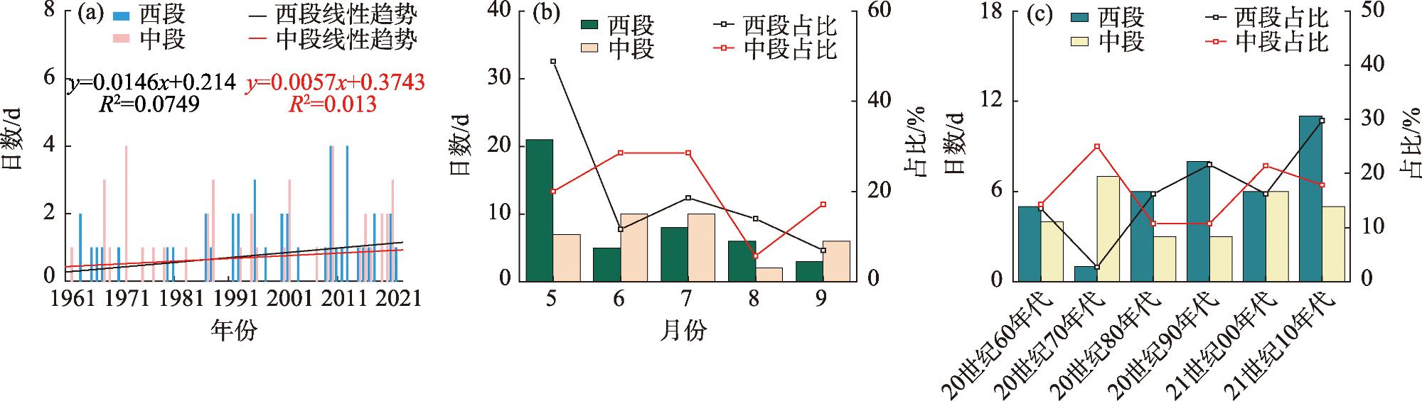
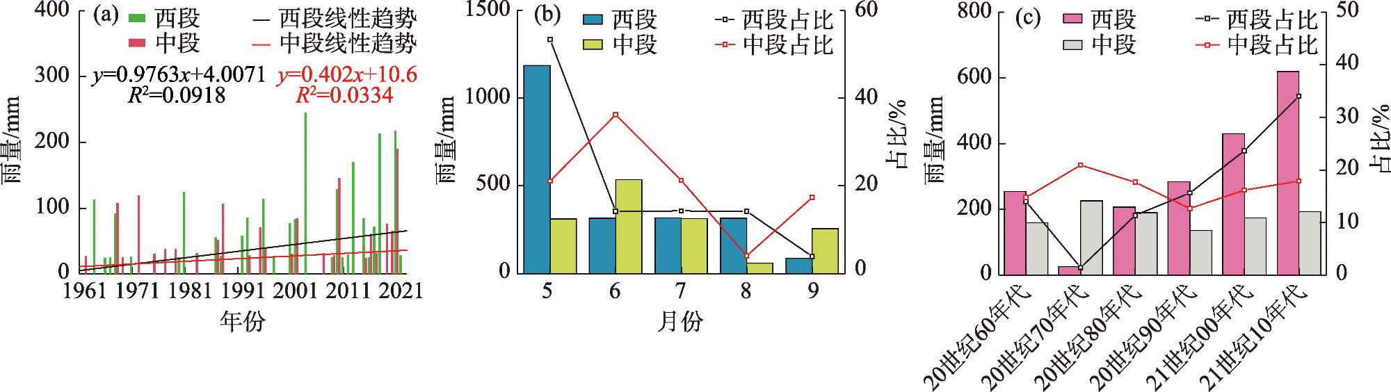
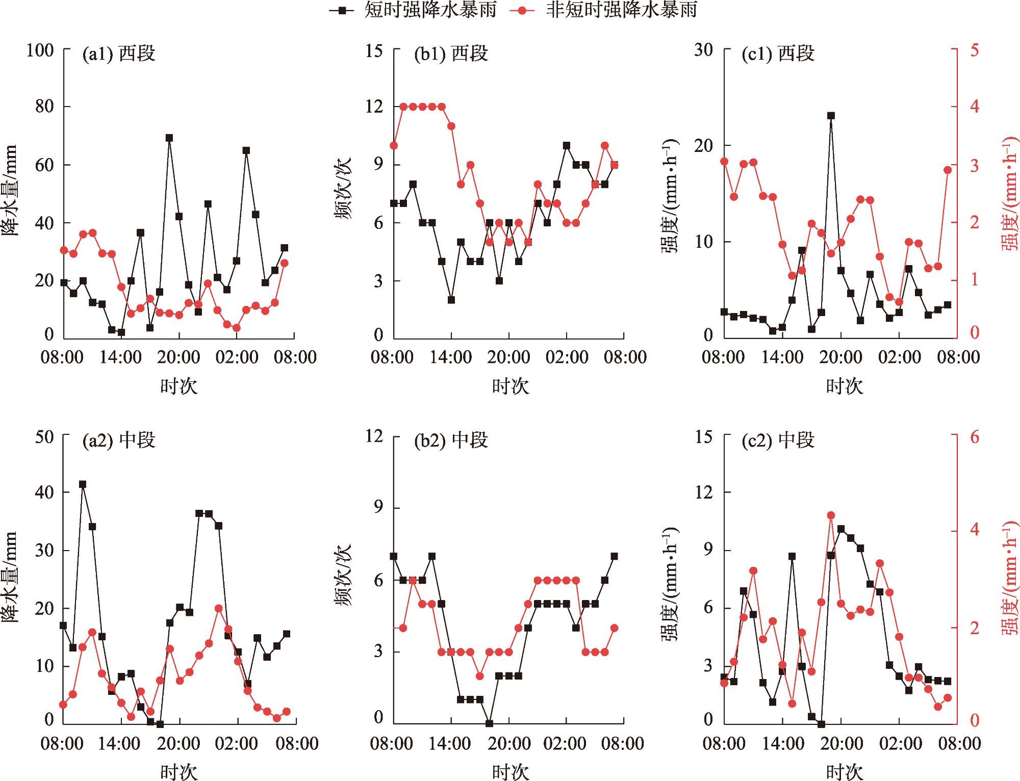
昆仑山是中国西部山系的主干,东西跨越范围大,全长约2500 km,按地势分为西昆仑山、中昆仑山和东昆仑山[1-2]。昆仑山北坡是丝绸之路经济带核心区建设的重要通道,地处中国西北内陆干旱区,水资源是影响该区域经济社会发展的关键因子[3-5]。昆仑山北坡降水量的年际变化较大[6-7],且年内分配不均匀,全年降水主要集中在5—8月,在空间上主要呈南部多北部少的特征[8]。近年来,随着全球气候变暖和新疆气候向暖湿化转型[9],昆仑山北坡的暴雨频繁发生[10],该区域一次暴雨过程的总降水量虽远小于中国东部季风区,但其暴雨过程的相对强度却可超过或与季风区暴雨相当[11-12]。2018年5月下旬,位于昆仑山北坡的皮山国家气象站出现极端大暴雨,1 h降水量达53.8 mm,接近当地的年平均降水量。2019年6月下旬,昆仑山北坡连续4 d出现大到暴雨,多站降水量突破历史极值,且末国家气象站的日降水量达48.8 mm,约为该地年平均降水量的1.5倍,极端暴雨过程引发山洪和泥石流,造成1.3×10⁴余人受灾,直接经济损失达5×10⁷元。昆仑山北坡暴雨的突发性强、历时短[13]、极端性强,目前,在实际预报业务中,对昆仑山北坡暴雨的空报和漏报较多,导致该区域暴雨灾害防御能力不足。
以往的研究多将昆仑山北坡与新疆南部(以下简称“南疆”)作为一个整体进行分析,对昆仑山北坡暴雨的特殊性关注不够[14-15]。目前,针对昆仑山北坡暴雨的研究相对较少,且主要以单一的天气个例分析为主[16-17]。干旱区暴雨的形成条件比季风区更加苛刻,需要大尺度环流背景和多尺度天气系统紧密配合[18]。研究表明,南亚高压、中亚低涡和塔里木东风低空急流是造成南疆暴雨的重要天气系统[19],南疆暴雨多由地面辐合线、中尺度低涡等中小尺度天气系统触发。水汽条件对干旱区暴雨至关重要,南疆不同区域暴雨的水汽来源和水汽输送路径具有较大的差别[20],高纬度西伯利亚地区,低纬度孟加拉湾、阿拉伯海和热带印度洋的水汽都与南疆暴雨有联系。南疆三面环山的地形造就了特殊的涡源和涡汇作用,在塔里木东风低空急流的配合下,为暴雨提供了有利的动力和水汽条件。研究表明,过去60 a,南疆暴雨的时空特征和影响系统都发生了显著变化[15],昆仑山北坡不同区域的暴雨在长时间尺度中发生了怎样的变化?其变化特征是否与南疆的整体变化特征一致?目前,上述问题还不明确。本文利用昆仑山北坡国家气象站降水资料和再分析资料,重点讨论昆仑山北坡不同区域暴雨的变化特征,以期为提高昆仑山北坡暴雨灾害风险防范能力提供参考。

1 资料

使用新疆气象信息中心提供的1961—2023年5—9月(暖季)昆仑山北坡14个国家气象站(图1)逐日降水资料和2010—2023年逐小时降水资料,分析昆仑山北坡西段(以下简称“西段”)和昆仑山北坡中段(以下简称“中段”)暴雨的气候特征及差异。
图1 昆仑山北坡西段和中段国家气象站分布

Fig. 1 Distribution of national meteorological stations in the western and middle sections of the north slope of the Kunlun Mountains

新疆地处干旱区,其暴雨和短时强降水的标准与全国的标准均不相同。新疆的暴雨指日降水量≥24.1 mm的降水事件[14],短时强降水指1 h降水量≥10.0 mm的降水事件[11]。若暴雨过程中同时出现了短时强降水事件,则定义此类暴雨为短时强降水暴雨,反之,若暴雨过程中未出现短时强降水事件,则定义此类暴雨为非短时强降水暴雨。文中“昼雨”指出现在08:00—20:00(均为北京时间)的降水,“夜雨”指出现在20:00至次日08:00的降水。

2 结果与分析

2.1 时间特征

2.1.1 暴雨日数

图2可以看出,1961—2023年,西段的累积暴雨日数和平均暴雨日数均多于中段。过去63 a,昆仑山北坡西段和中段的暴雨日数均呈增加趋势,其中西段平均每10 a增加0.1 d,增加趋势通过了α=0.05的信度检验,中段的增加趋势较弱,未能通过显著性检验(图2a)。昆仑山北坡西段的暴雨主要出现在5月,占比高达48.8%,其次为7月(18.6%),9月最少(7.0%);中段的暴雨日数在暖季各月的分布与西段差异较大,该区域6月和7月的暴雨日数最多,占比均为28.6%,其次为5月(20.0%),8月最少(5.7%)(图2b)。昆仑山北坡西段和中段的暴雨日数在年代际时间尺度上也存在较大差异(图3c),西段的暴雨日数在21世纪10年代最多,20世纪70年代最少;中段在20世纪70年代最多,20世纪80—90年代最少,总体来看,二者的暴雨日数在不同年代的占比呈反向变化的特征。综上可知,昆仑山北坡的暴雨日数存在明显的区域差异,西段和中段的暴雨日数在不同时间尺度的变化特征不同,二者的变化特征并不同步。
图2 昆仑山北坡西段和中段的暴雨日数在不同时间尺度的变化特征

Fig. 2 Characteristics of the number of days of heavy rainfall in the western and middle sections of the north slope of the Kunlun Mountains at different time scales

图3 昆仑山北坡西段和中段的暴雨量在不同时间尺度的变化特征

Fig. 3 Characteristics of heavy rainfall in the western and middle sections of the north slope of the Kunlun Mountains at different time scales

2.1.2 暴雨量

图3可以看出,与暴雨日数类似,1961—2023年,昆仑山北坡西段和中段的暴雨量也均呈增加趋势,其中西段平均每10 a增加9.8 mm,增加趋势通过了α=0.05的信度检验,中段平均每10 a增加4.0 mm,但未能通过显著性检验(图3a)。1961—2023年,昆仑山北坡西段(中段)的累积暴雨量为2221.0 mm(1478.5 mm),年平均暴雨量为34.7 mm(23.1 mm)。与暴雨日数类似,西段的暴雨量也在5月最多,该月的累积暴雨量占比高达53.4%,西段夏季各月的累积暴雨量占比接近,约为14.2%,9月最少,不足4.0%。中段的暴雨量在各月的分布与暴雨日数不同,虽然6月和7月累积暴雨日数的占比一样多,但6月的累积暴雨量占比(36.2%)却比7月(21.3%)多14.9%(图3b)。从年代际尺度来看(图3c),昆仑山北坡西段和中段暴雨量的占比在20世纪60—90年代呈反向变化的特征,进入21世纪后二者表现出一致的增加趋势。研究显示,南疆的气候自20世纪80年代后期开始,由暖干向暖湿转型,降水量呈明显的阶段性增长特征[15],由图3c可以看出,昆仑山北坡西段的暴雨量自20世纪90年代起显著增多,该区域20世纪60—80年代的暴雨量占总暴雨量的26.8%,20世纪90年代至21世纪10年代的暴雨量占总暴雨量的73.2%,即西段的暴雨量主要出现在暖湿阶段。中段的暴雨量与西段不同,该区域20世纪60—80年代的暴雨量占总暴雨量的53.3%,20世纪90年代至21世纪10年代的暴雨量占总暴雨量的46.7%,即中段的暴雨量主要出现在暖干阶段。可见,昆仑山北坡不同区域的暴雨量对气候转型的响应程度不同。

2.2 空间特征

昆仑山北坡西段和中段的累积暴雨日数的空间分布差异较大,西段总体呈“东多西少”的特征,累积暴雨日数的大值区位于77°E附近,而中段呈“中间多两边少”的特征,累积暴雨日数由81°E向东西两侧逐渐减少(图4a)。昆仑山北坡西段和中段累积暴雨量的空间分布特征与累积暴雨日数类似(图4b)。昆仑山北坡西段平均暴雨量的空间分布特征与累积暴雨量相似,但在中段二者的空间分布却相反,即中段平均暴雨量的空间分布呈“中间少两边多”的特征(图4c)。对比图4a~图4b可知,昆仑山北坡西段和中段累积暴雨量大,主要由暴雨日数多造成,但在个别站点,其累积暴雨量较少,但平均暴雨量却较大。如位于昆仑山北坡中段的墨玉站,其累积暴雨量是本文研究区域中最少的,但其平均暴雨量却是最大的,过去63 a,墨玉站仅出现了一次暴雨,因此累积暴雨量最少,但在这次暴雨中墨玉站的降水量达59.6 mm,约为其年降水量的1.5倍。昆仑山北坡中段暴雨的空间分布特征,也反映出干旱区暴雨的特殊性,即年暴雨次数和暴雨量与中国东部季风区相比都相差甚远,但暴雨的相对强度却较大,甚至超过季风区暴雨[14]。昆仑山北坡西段的日最大暴雨量大致呈自东向西逐渐减小的分布特征,即皮山站最大(74.6 mm),喀什站最小(39.9 mm);中段日最大暴雨量的空间分布特征与平均暴雨量类似,洛浦站日最大暴雨量最大(74.1 mm),策勒站最小(37.9 mm)。可见,虽然昆仑山北坡中段的累积暴雨量较西段明显偏少,但二者日最大暴雨量的差异较小,说明虽然昆仑山北坡中段暴雨的出现频次不如西段多,但暴雨的极值雨量二者差异不大。
图4 1961—2023年昆仑山北坡西段和中段的暴雨日数和暴雨量空间分布

Fig. 4 Spatial distribution of heavy rainfall days and heavy rainfall in the western and middle sections of the north slope of the Kunlun Mountains from 1961 to 2023

2.3 短时强降水事件特征

干旱区暴雨过程中常伴有短时强降水事件[14],由图5a可以看出,2010—2023年,除喀什站外,昆仑山北坡西段和中段其余各站在暴雨日中均有短时强降水事件出现,该比例超过90%,远高于南疆其他区域[11]。昆仑山北坡西段和中段的短时强降水暴雨日数的空间分布特征与各自的累积暴雨日数类似,累积暴雨日数较多的站点,出现短时强降水暴雨的日数也较多。从图5b可以看出,西段短时强降水暴雨日数的占比普遍低于中段,二者区域平均的占比分别为44%和69%。昆仑山北坡短时强降水暴雨量的空间分布也存在明显的区域差异,西段短时强降水暴雨量的空间分布呈自东向西显著减少的特征,叶城站的累积短时强降水暴雨量约为阿克陶站的8.5倍;中段各站的短时强降水暴雨量的差异小于西段,洛浦站的累积短时强降水暴雨量最多,于田站最少,二者相差约3倍(图5c)。由图5d可以进一步看出,与短时强降水暴雨日数类似,昆仑山北坡中段短时强降水暴雨量的占比也高于西段,特别是中段东西两侧累积暴雨日数较少的站点,在暴雨中伴随短时强降水事件的比例高达100%。综上可知,昆仑山北坡西段总体以非短时强降水暴雨为主,而中段以短时强降水暴雨为主。水汽是形成暴雨的重要条件,由于昆仑山北坡西段的水汽条件优于中段[14],因此,西段的暴雨日数更多,除了在强对流天气中出现短时强降水暴雨外,稳定的长时间降水也会出现暴雨;而中段由于常年水汽匮乏[20],出现暴雨的条件更为苛刻,只有在强对流天气过程中,形成强烈的上升运动,同时依靠中小尺度天气系统将周边水汽快速向降水区汇合才能形成暴雨,因此,暴雨过程中更易出现短时强降水事件。
图5 2010—2023年昆仑山北坡西段和中段的累积短时强降水暴雨日数和暴雨量及其占比

Fig. 5 Cumulative short duration heavy precipitation rainstorm days and rainstorm amount and their percentage in the western and middle sections of the north slope of the Kunlun Mountains from 2010 to 2023

2.4 日变化

降水日变化存在显著的区域差异[21],但以往多将南疆作为一个整体,来研究其不同类型降水的日变化特征[11],因此,无法揭示不同区域降水日变化的差异。由图6可以看出,昆仑山北坡西段短时强降水暴雨的累积降水量明显多于非短时强降水暴雨,二者的日变化呈反位相分布特征,短时强降水暴雨的大值时段主要出现在15:00至次日05:00,而非短时强降水暴雨主要在07:00—13:00。与累积降水量不同,昆仑山北坡西段非短时强降水暴雨的累积降水频次多于短时降水暴雨,非短时(短时)强降水暴雨降水频次的大值时段在09:00—13:00(02:00—04:00),低值时段在18:00—22:00(13:00—21:00)。昆仑山北坡西段短时强降水暴雨的强度在08:00—14:00小于非短时强降水暴雨,其他时段基本都大于非短时强降水暴雨。对比图6a1~图6c1可以看出,昆仑山北坡西段短时强降水暴雨的累积降水量在清晨至上午时段较小,主要与降水强度小有关,该区域非短时强降水暴雨在这一时段降水量多,与降水频次多、降水强度大有关。昆仑山北坡中段累积降水量的日变化特征与西段不同,该区域2类暴雨的日变化特征一致,均呈双峰型分布。昆仑山北坡中段的2类暴雨在08:00至次日03:00的日变化分布特征一致,在04:00—07:00呈反位相分布特征。中段2类暴雨的降水强度在18:00至次日11:00的日变化特征一致,在12:00—17:00呈反位相分布特征。综上可知,昆仑山北坡西段和中段不同类型暴雨的日变化特征存在差异,这2个区域相同类型暴雨的日变化特征也存在较大差异,昆仑山北坡西段短时强降水暴雨的大值时段集中在午后到前半夜(19:00的累积降水量最大),而中段除了这一时段外,在上午还存在一个累积降水量的峰值时段(10:00的累积降水量最大)。
图6 2010—2023年昆仑山北坡西段和中段不同类型暴雨的日变化特征

Fig. 6 Characteristics of daily changes of different types of rainstorms in the western and middle sections of the north slope of the Kunlun Mountains from 2010 to 2023

表1可以看出,昆仑山北坡西段暴雨总体上呈夜雨多于昼雨的特征,该区域短时强降水暴雨的昼夜分布比例与总暴雨类似,非短时强降水暴雨的昼夜分布比例与总暴雨和短时强降水暴雨相反,呈昼雨多于夜雨的特征。中段不同类型暴雨的昼夜分布特征的一致性较好,均呈夜雨多于昼雨的特征。可见,昆仑山北坡西段和中段的暴雨整体都呈夜雨多于昼雨的分布,但二者的非短时强降水暴雨的昼夜分布却存在明显差异,过去的研究[22]主要将南疆暴雨作为一个整理研究,认为南疆夜雨多,主要与低空急流在夜间加强有关,而对于造成昆仑山北坡非短时强降水暴雨昼夜分布的区域差异,还需要进一步深入研究。
表1 2010—2023年昆仑山北坡西段和中段不同类型暴雨降水量的昼夜比例

Tab. 1 Diurnal proportions of precipitation for different types of storms in the western and middle sections of the north slope of the Kunlun Mountains, 2010-2023

区域 总暴雨/% 短时强降
水暴雨/%
非短时强
降水暴雨/%
白天 夜间 白天 夜间 白天 夜间
西段 49.4 50.6 42.6 57.4 59.4 40.6
中段 43.6 56.4 41.8 58.2 47.6 52.4

2.5 持续时间

1961—2023年,昆仑山北坡西段(喀什站和叶城站)和中段(策勒站)仅有3个站出现过连续2 d的暴雨过程,其余各站的暴雨过程均为1 d。可见,干旱区由于水汽匮乏,暴雨过程中水汽的持续供应能力较差,因此,同一区域不易出现连续多日的暴雨过程[14]。由表2可以看出,昆仑山北坡西段暴雨的平均降水时数为13 h,该区域短时强降水暴雨的降水时数(7.9 h)约为非短时强降水暴雨(18.1 h)的44%;昆仑山北坡中段暴雨的平均降水时数与西段接近(13.5 h),其短时强降水暴雨的平均降水时数(11.6 h)约为非短时强降水暴雨(15.4 h)的75.3%。可见,昆仑山北坡西段和中段暴雨整体的平均降水时数差异不大,但西段的短时强降水暴雨的平均降水时数比中段短约3 h,非短时强降水暴雨的平均降水时数比中段长约3 h。
表2 2010—2023年昆仑山北坡西段和中段不同类型暴雨的平均降水时数

Tab. 2 Mean hours of precipitation for different types of storms in the western and middle sections of the north slope of the Kunlun Mountains, 2010-2023

区域 总暴雨/h 短时强
降水暴雨/h
非短时强
降水暴雨/h
西段 13.0 7.9 18.1
中段 13.5 11.6 15.4

2.6 主要影响系统

暴雨是多尺度天气系统共同作用的产物[10]。研究表明,南亚高压、中亚低涡(槽)、塔里木东风低空急流是造成南疆暴雨的重要高(100 hPa)、中(500 hPa)、低(850 hPa)层大尺度天气系统[14,23]。由表3可以看出,在昆仑山北坡西段暴雨中,100 hPa南亚高压以“青藏高压型”为主(57.1%),其次为“双体型”(31.0%),第三为“伊朗高压型”(7.1%),“带状型”最少(4.8%);500 hPa影响系统中,中亚低槽(54.8%)的出现比例高于中亚低涡(45.2%),850 hPa有塔里木东风低空急流的占比(61.9%)明显高于无塔里木东风低空急流的占比(38.1%)。对比昆仑山北坡中段暴雨与西段暴雨的高、中、低层各类型天气系统的占比,不难发现,二者在不同层次的主要影响系统和类型一致,即100 hPa南亚高压均以“青藏高压型”为主,500 hPa影响系统以中亚低槽为主,850 hPa以有塔里木东风低空急流居多(图7)。研究表明[14,16],当100 hPa的南亚高压为“青藏高压型”时,控制南疆的副热带西风槽向南加深,暴雨区高空辐散作用加强,500 hPa中亚低槽槽前西南气流有利于南支水汽向暴雨区输送,此外,低槽前部的正涡度平流也为暴雨的形成提供了有利的大尺度抬升运动,由于南疆三面环山,850 hPa塔里木东风低空急流使低层气流辐合上升,低空急流引起的辐合区与高空急流的辐散区在暴雨区上空耦合,进一步促进了整层大气的垂直上升运动发展,与此同时,塔里木东风低空急流还将低层水汽不断向暴雨区输送和汇聚,从而为暴雨提供了持续的水汽供应。
表3 各类天气系统在昆仑山北坡西段和中段暴雨中的占比

Tab. 3 Proportion of each type of weather system in different areas of heavy rainfall in the western and middle sections of the north slope of the Kunlun Mountains /%

区域 100 hPa南亚高压 500 hPa影响系统 850 hPa东风急流
双体型 青藏高压型 伊朗高压型 带状型 中亚低槽 中亚低涡
西段 31.0 57.1 7.1 4.8 54.8 45.2 61.9 38.1
中段 31.3 34.4 18.8 15.6 90.6 9.4 68.8 31.3
图7 昆仑山北坡西段和中段暴雨高低空系统的典型配置模型

Fig. 7 Modeling of high and low altitude system configurations during simultaneous heavy rainfall in the western and middle sections of the north slope of the Kunlun Mountains

综上可知,由于在昆仑山北坡西段和中段出现暴雨时,其高、中、低层的主要天气系统的典型配置是一致的,因此,很难根据大尺度环流背景来确定暴雨的准确落区,这也是昆仑山北坡暴雨落区预报难度大的主要原因之一。研究表明[10],暴雨是在有利的天气背景下,由中小尺度天气系统直接产生的,因此,如何在相同的天气背景下,判识导致中小尺度天气系统的发展和演变,是准确预报昆仑山北坡暴雨落区的关键,这一问题将在以后的研究中详细讨论。

3 结论与讨论

通过对1961—2023年昆仑山北坡西段和中段暴雨的气候特征和环流差异研究,得出如下主要结论:
(1)昆仑山北坡西段的暴雨日数和暴雨量均多于中段;1961—2023年,西段和中段的暴雨日数和暴雨量均呈增加趋势,但西段的增加趋势更显著;西段的暴雨日数和暴雨量均在5月最多,中段的暴雨日数在6月和7月最多,而暴雨量在6月最多。西段和中段的暴雨日数在不同年代的占比呈反向变化特征。昆仑山北坡西段和中段的暴雨量对气候转型的响应程度不同,西段的暴雨量主要出现在暖湿阶段,而中段则主要出现在暖干阶段。
(2)昆仑山北坡不同区域暴雨日数和暴雨量的空间分布差异较大,累积暴雨日数和暴雨量在西段均呈“东边多西边少”的特征,在中段则呈 “中间多两边少”的特征,西段平均暴雨量的空间分布与其累积暴雨量一致,中段二者却相反;昆仑山北坡西段和中段的极值暴雨量的差异不大。昆仑山北坡90%以上的站点在暴雨日中都出现过短时强降水事件,该比例高于南疆平均值;西段以非短时强降水暴雨为主,中段以短时强降水暴雨为主。
(3)昆仑山北坡暴雨的持续性较差,同一区域连续2 d的暴雨过程较为罕见;西段和中段暴雨的平均降水时数接近,西段(非)短时强降水暴雨的平均降水时数比中段短(长)约3 h;昆仑山北坡暴雨整体呈夜雨多于昼雨的特征,西段和中段的非短时强降水暴雨的昼夜分布特征相反。
(4)昆仑山北坡西段和中段出现暴雨时,其高、中、低层主要天气系统的典型配置是一致的(即100 hPa南亚高压以“青藏高压型”为主;500 hPa影响系统以中亚低槽为主,850 hPa多伴有塔里木东风低空急流),从而导致暴雨精细落区预报难度大。
昆仑山北坡的降水是南疆水资源的主要补给[24-25]之一,优化降水资源的开发和利用对该地区社会经济的可持续发展具有重要意义[26-28]。以往昆仑山区的气象观测资料较为匮乏,限制了对其降水特征的深入研究。近年来,随着气象现代化站网的建设,特别是2023年在昆仑山北坡海拔5000 m以上区域成功布设的自动气象观测站,为获取高时空分辨率的降水资料提供了可能。下一步将利用这些资料深入分析昆仑山北坡降水的精细特征,以期提高对昆仑山北坡暴雨事件的理解,并为该区域暴雨灾害防御和水资源管理提供科学依据。
[1]
郑度, 潘裕生, 武素功, 等. 昆仑山区综合科学考察的新进展[J]. 山地研究, 1989, 7(2): 111-115.

[Zheng Du, Pan Yusheng, Wu Sugong, et al. Recent progresses of the integrated scientific expedition of the Kunlun Mountains[J]. Mountain Research, 1989, 7(2): 111-115. ]

[2]
孙鸿烈, 郑度. 喀喇昆仑山—昆仑山地区综合科学考察[J]. 中国科学基金, 1990(2): 1-6.

[Sun Honglie, Zheng Du. Comprehensive scientific investigation on the Korra Kunlun-Kunlun Mountain areas[J]. Bulletin of National Natural Science Foundation of China, 1990(2): 1-6. ]

[3]
达伟, 王书峰, 沈永平, 等. 1957—2019年昆仑山北麓车尔臣河流域水文情势及其对气候变化的响应[J]. 冰川冻土, 2022, 44(1): 46-55.

DOI

[Da Wei, Wang Shufeng, Shen Yongping, et al. Hydrological response to the climatic changes in the Qarqan River Basin at the northern slope of Kunlun Mountains during 1957-2019[J]. Journal of Glaciology and Geocryology, 2022, 44(1): 46-55. ]

DOI

[4]
Duan Yongchao, Liu Tie, Meng Fanhao, et al. Accurate simulation of ice and snow runoff for the mountainous terrain of the Kunlun Mountains, China[J]. Remote Sensing, 2020, 12: 179.

[5]
Song Lingling, Xu Changchun, Long Yunxia, et al. Performance of seven gridded precipitation products over arid central asia and subregions[J]. Remote Sensing, 2022, 14: 6039.

[6]
韩兴胜. 中昆仑山北坡降水量变化特征分析[J]. 人民长江, 2017, 48(S2): 85-88.

[Han Xingsheng. Characteristics of precipitation variation on the northern slope of central Kunlun Mountain[J]. Yangtze River, 2017, 48(S2): 85-88. ]

[7]
许有鹏, 高蕴珏, 杨戍. 昆仑山北坡河流水文水资源特征研究[J]. 地理科学, 1994, 14(4): 338-346, 390.

[Xu Youpeng, Gao Yunyu, Yang Wu. Approach to water resource characteristics of rivers in north slope area of the Kunlun Mountains[J]. Scientia Geographica Sinica, 1994, 14(4): 338-346, 390. ]

DOI

[8]
张俊兰, 杨霞, 肖俊安, 等. 昆仑山北部夏季降水多尺度时空变化特征[J]. 高原山地气象研究, 2023, 43(3): 1-10.

[Zhang Junlan, Yang Xia, Xiao Jun’an, et al. Multi-scale temporal and spatial variation characteristics of summer precipitation in northern Kunlun Mountains[J]. Plateau and Mountain Meteorology Research, 2023, 43(3): 1-10. ]

[9]
施雅风, 沈永平, 李栋梁, 等. 中国西北气候由暖干向暖湿转型的特征和趋势探讨[J]. 第四纪研究, 2003, 23(2): 152-164.

[Shi Yafeng, Shen Yongping, Li Dongliang, et al. Discussion on the present climate change from warm-dry to warm-wet in Northwest China[J]. Quaternary Sciences, 2003, 23(2): 152-164. ]

[10]
谢泽明, 周玉淑, 杨莲梅. 新疆降水研究进展综述[J]. 暴雨灾害, 2018, 37(3): 204-212.

[Xie Zeming, Zhou Yushu, Yang Lianmei. Review of study on precipitation in Xinjiang[J]. Torrential Rain and Disasters, 2018, 37(3): 204-212. ]

[11]
杨霞, 周鸿奎, 许婷婷, 等. 南疆夏季不同类型暴雨精细化特征对比分析[J]. 干旱区研究, 2021, 38(3):747-756.

DOI

[Yang Xia, Zhou Hongkui, Xu Tingting, et al. Comparative analysis of the fine characteristics of different rainstorms in southern Xinjiang during summer[J]. Arid Zone Research, 2021, 38(3): 747-756. ]

DOI

[12]
张俊兰, 杨霞, 施俊杰. 青藏高原天气系统对昆仑山北坡一次罕见暴雨过程影响分析[J]. 高原气象, 2021, 40(5): 1002-1011.

DOI

[Zhang Junlan, Yang Xia, Shi Junjie. Analysis of the influence of the Qinghai-Xizang Plateau weather system on a rare rainstorm process on the northern slope of Kunlun Mountain[J]. Plateau Meteorology, 2021, 40(5): 1002-1011. ]

DOI

[13]
张俊兰, 李伟, 郑育琳. 昆仑山北坡短时强降水天气分型及雷达回波特征分析[J]. 沙漠与绿洲气象, 2022, 16(1): 1-9.

[Zhang Junlan, Li Wei, Zheng Yulin. Weather classification and radar echo characteristics of short-term heavy precipitation in the northern Kunlun Mountains[J]. Desert and Oasis Meteorology, 2022, 16(1): 1-9. ]

[14]
张家宝, 邓子风. 新疆降水概论[M]. 北京: 气象出版社, 1987: 400.

[Zhang Jiabao, Deng Zifeng. Introduction to Precipitation in Xinjiang[M]. Beijing: China Meteorological Press, 1987: 400. ]

[15]
杨霞, 许婷婷, 张林梅, 等. 不同气候背景下南疆暖季暴雨特征和差异[J]. 干旱气象, 2022, 40(2): 222-233.

DOI

[Yang Xia, Xu Tingting, Zhang Linmei, et al. Characteristics and differences of rainstorm in the southern Xinjiang during warm season under different climatic backgrounds[J]. Journal of Arid Meteorology, 2022, 40(2): 222-233. ]

[16]
杨霞, 张云惠, 张超, 等. 南疆西部“5·21”极端大暴雨成因分析[J]. 沙漠与绿洲气象, 2020, 14(1): 21-30.

[Yang Xia, Zhang Yunhui, Zhang Chao, et al. Causation analysis of the 21 May 2018 torrential rain in the west of southern Xinjiang[J]. Desert and Oasis Meteorology, 2020, 14(1): 21-30. ]

[17]
李晓萌, 杨莲梅, 李建刚, 等. 昆仑山北坡“6·14”极端暴雨过程的中尺度对流系统特征分析[J]. 干旱区地理, 2024, 10(47): 1700-1712.

[Li Xiaomeng, Yang Lianmei, Li Jiangang, et al. Mesoscale convective systems characteristic analysis of the “6·14” extreme rainstorm in northern slope of the Kunlun Mountains[J]. Arid Land Geography, 2024, 10(47): 1700-1712. ]

[18]
Sun Qi, Abuduwaili Abulikemu, Yao Junqiang, et al. A case study on the convection initiation mechanisms of an extreme rainstorm over the northern slope of Kunlun Mountains, Xinjiang, Northwest China[J]. Remote Sensing, 2023, 15: 4505.

[19]
杨霞, 何清, 赵克明, 等. 基于加密探空资料的塔里木东风低空急流特征[J]. 山地学报, 2023, 41(6):836-845.

[Yang Xia, He Qing, Zhao Keming, et al. Characteristics of the easterly low-level jet in Tarim based on encrypted radiosonde observations[J]. Mountain Research, 2023, 41(6): 836-845. ]

[20]
于碧馨, 刘晶, 安大维, 等. 2017—2019年南疆西部和昆仑山北坡GPS大气可降水量变化特征[J]. 沙漠与绿洲气象, 2022, 16(6):25-33.

[Yu Bixin, Liu Jing, An Dawei, et al. Variation characteristics of GPS precipitable water vapor over the west of southern Xinjiang and the northern slope of Kunlun Mountains during 2017-2019[J]. Desert and Oasis Meteorology, 2022, 16(6): 25-33. ]

[21]
宇如聪, 李建, 陈昊明, 等. 中国大陆降水日变化研究进展[J]. 气象学报, 2014, 72(5): 948-968.

[Yu Rucong, Li Jian, Chen Haoming, et al. Progress in studies of the precipitation diurnal variation over contiguous China[J]. Acta Meteorological Sinica, 2014, 72(5): 948-968. ]

[22]
崔彩霞, 李扬, 杨青. 新疆夜雨和昼雨的空间分布和长期变化[J]. 中国沙漠, 2008, 28(5): 903-909.

[Cui Caixia, Li Yang, Yang Qing. Spatial distribution and long-term variation of nocturnal and daytime rainfall in Xinjiang[J]. Journal of Desert Research, 2008, 28(5): 903-909. ]

[23]
钱永甫, 张琼, 张学洪. 南亚高压与我国盛夏气候异常[J]. 南京大学学报(自然科学版), 2002, 38(3): 295-307.

[Qian Yongfu, Zhang Qiong, Zhang Xuehong. The South Asian high and its effects on China’s mid-summer climate abnormality[J]. Journal of Nanjing University(Natural Sciences), 2002, 38(3): 295-307. ]

[24]
Yao Junqiang, Chen Yaning, Guan Xuefeng, et al. Recent climate ang hydrological changes in a mountain-basin system in Xinjiang, China[J]. Earth-Science Reviews, 2022, 226: 103957.

[25]
毛炜峄, 玉素甫·阿布都拉, 程鹏, 等. 1999年夏季中昆仑山北坡诸河冰雪大洪水及其成因分析[J]. 冰川冻土, 2007, 29(4): 553-558.

[Mao Weiyi, Yusupu Abudula, Cheng Peng, et al. Extreme flood events in 1999 and their formation conditions in northern slopes of the Middle Kunlun Mountains[J]. Journal of Glaciology and Geocryology, 2007, 29(4): 553-558. ]

[26]
Li Man, Zhang Zaiyong, Ju Chenxiang, et al. Sensitivity of temperature and precipitation characteristics to land use classification over the Taklimakan Desert and surrounding area[J]. Theoretical and Applied Climatology, 2023, 154: 987-998.

[27]
Li Jiawei, Sun Meiping, Yao Xiaojun, et al. A review of Karakoram glacier anomalies in high mountains asia[J]. Water, 2023, 15: 3215.

[28]
Niu Shuting, Sun Meiping, Wang Guoyu, et al. Glacier change and its influencing factors in the northern part of the Kunlun Mountains[J]. Remote Sensing, 2023, 15: 3986.

Outlines

/