
Identification of priority areas for the ecological protection and restoration of the Yellow River Basin in Inner Mongolia
Received date: 2024-07-31
Revised date: 2024-09-10
Online published: 2025-08-13
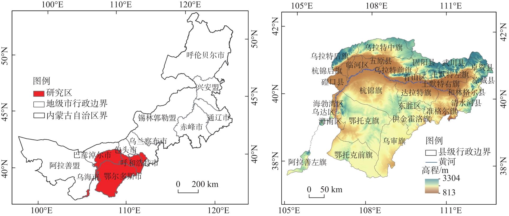
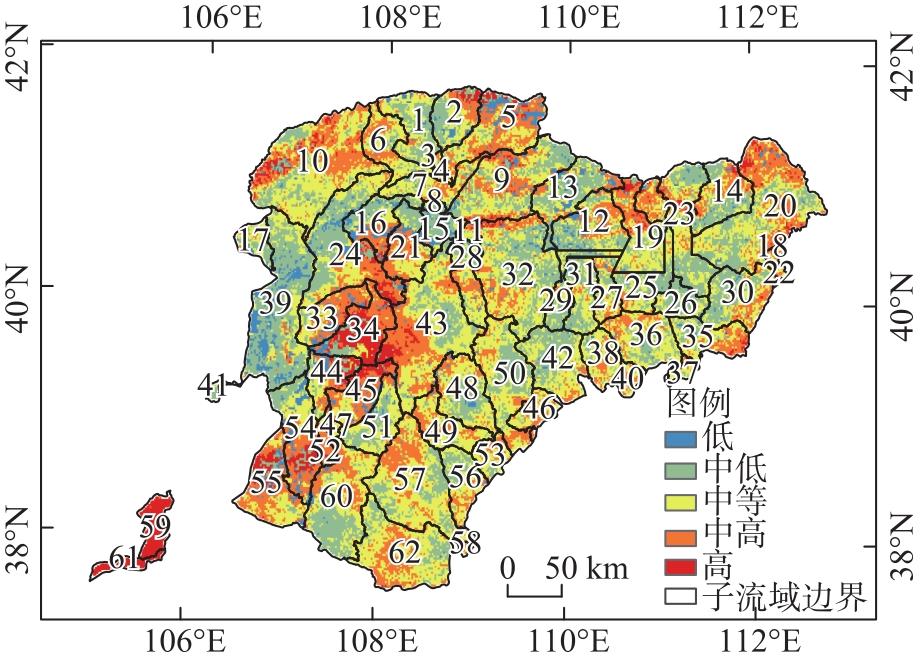
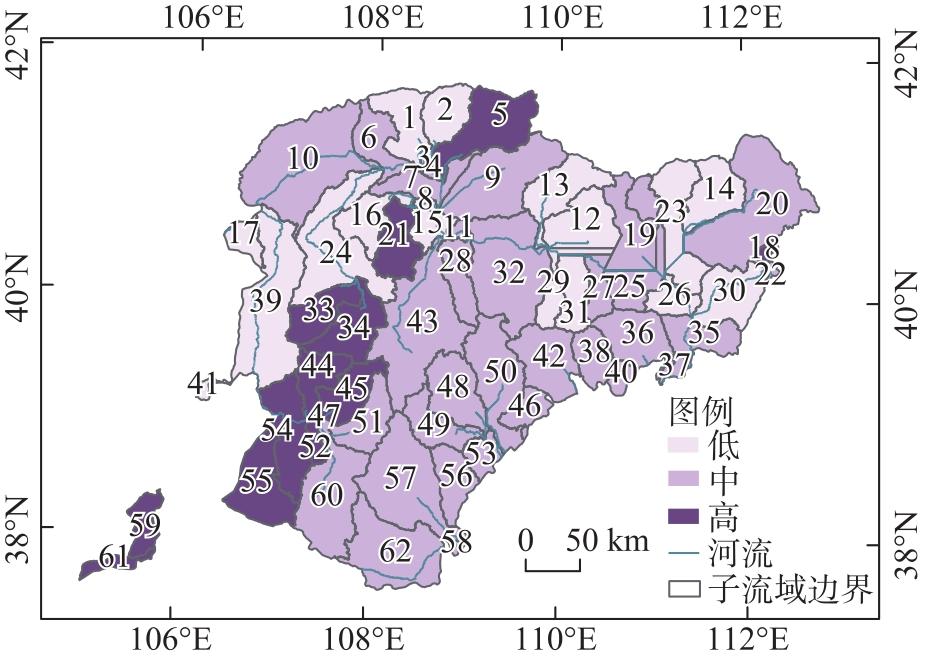
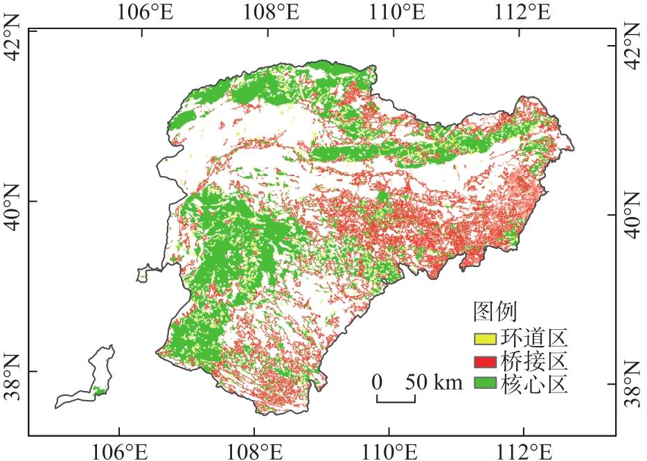
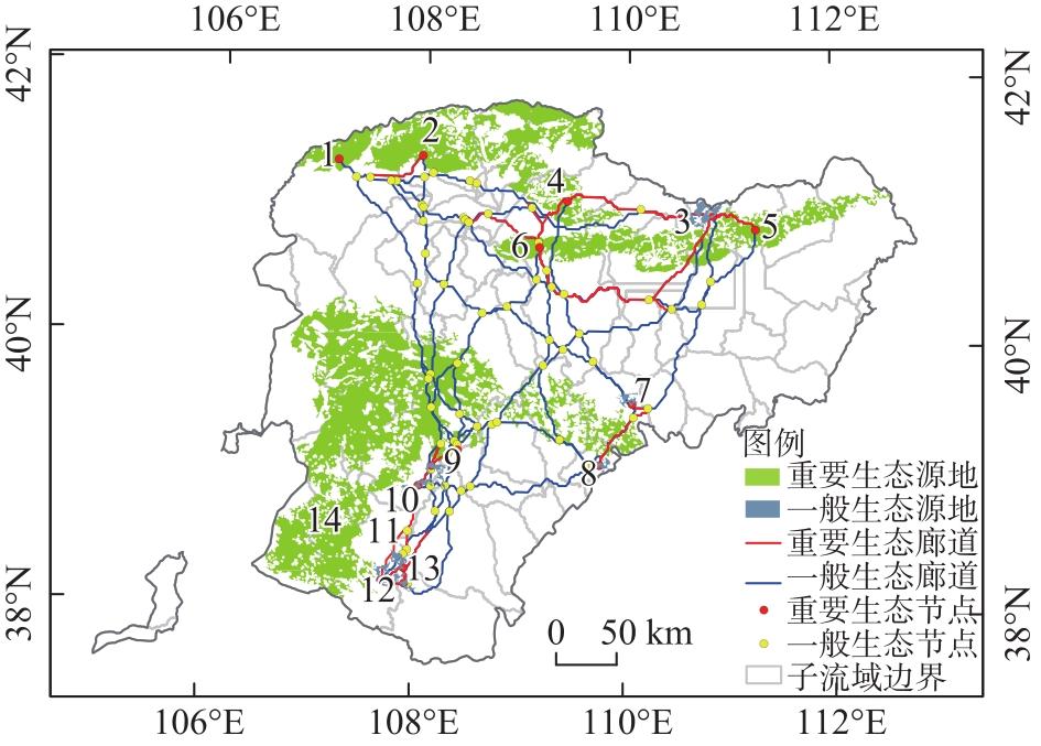
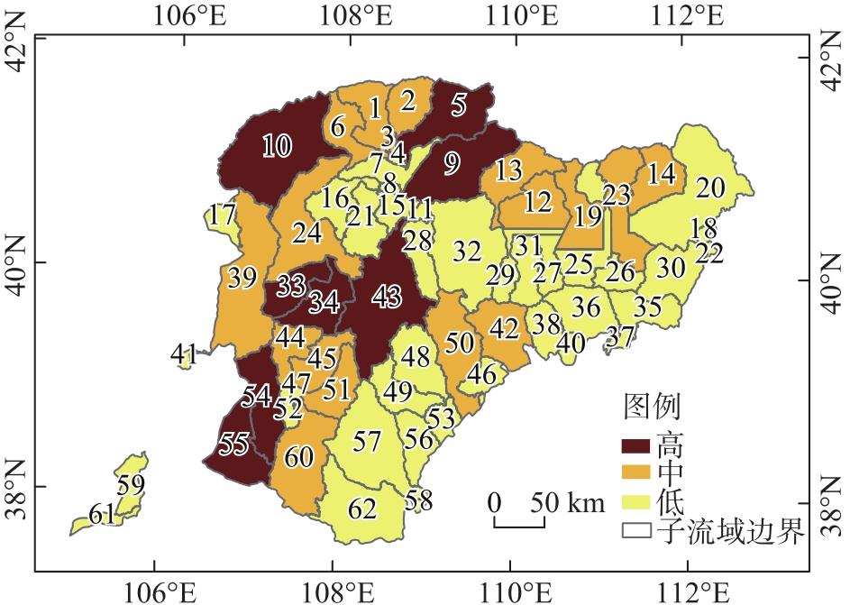
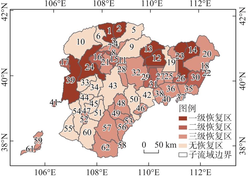
Finding ways to scientifically identify the priority areas of ecological protection and restoration and implement adapted strategies in different regions is a challenge faced by current ecological protection and restoration work. This study was based on the Yellow River Basin in Inner Mongolia, and the ecological security evaluation was conducted using spatial principal component analysis (SPCA) and morphological spatial pattern analysis (MSPA). The ecological protection and restoration areas were identified by combining the matching degree of landscape elements. The results indicated that (1) the study area was dominated by areas with moderate ecological security, accounting for 40.58% of the total area. (2) 14 ecological sources (accounting for 20.92% of the study area), 42 ecological corridors, and 78 ecological nodes were identified by MSPA and minimum cumulative resistance model (MCR). (3) among the 62 sub-watersheds in the study area, 8 had a high matching level of landscape elements, accounting for 23.34% of the total area, and 38 watersheds had a low matching level, accounting for 43.20% of the total area. and (4) the priority areas of the third- and first-level ecological restoration accounted for 35.53% (the largest) and 18.63%, respectively. Based on the identification results of priority areas of ecological protection and restoration, the restoration strategies of different regions were discussed. Our results can provide a basis for ecological protection and high-quality development of the Yellow River Basin in Inner Mongolia.
LU Ying , ZHANG Min , WANG Yange . Identification of priority areas for the ecological protection and restoration of the Yellow River Basin in Inner Mongolia[J]. Arid Zone Research, 2024 , 41(11) : 1946 -1955 . DOI: 10.13866/j.azr.2024.11.14
表1 数据来源Tab. 1 Data sources |
| 数据名称 | 格式 | 空间分辨率 | 来源 |
|---|---|---|---|
| 数字高程模型(DEM) | 栅格数据 | 30 m | 地理空间数据云(http://www.gscloud.cn/) |
| 归一化植被指数(NDVI) | 栅格数据 | 30 m | 数字地球开放平台(https://open.geovisearth.com/) |
| 土壤类型 | 栅格数据 | 1000 m | 国家冰川冻土沙漠科学数据中心(http://www.ncdc.ac.cn) |
| 土地利用 | 栅格数据 | 30 m | 中国科学院资源环境科学数据中心(http://www.resdc.cn) |
| 道路数据 | 矢量数据 | - | OSM官网(https://download.geofabrik.de/) |
| 夜间灯光 | 栅格数据 | 1000 m | Harvard Dataverse平台 |
表2 内蒙古黄河流域生态恢复优先区域分类Tab. 2 Priority regional classification of ecological restoration in the Yellow River Basin of Inner Mongolia |
| 生态安全水平等级 | 景观要素匹配等级 | ||
|---|---|---|---|
| 高 | 中 | 低 | |
| 高 | - | - | 三级恢复区 |
| 中 | - | - | 三级恢复区 |
| 低 | 一级恢复区 | 一级恢复区 | 二级恢复区 |
表3 生态安全评价指标体系Tab. 3 Ecological security evaluation index system |
| 评价维度 | 评价指标 | 生态安全等级分级标准 | ||||
|---|---|---|---|---|---|---|
| 一 | 二 | 三 | 四 | 五 | ||
| 自然因素 | 海拔/m | 1730~3304 | 1482~1730 | 1309~1482 | 1139~1309 | 813~1139 |
| 坡度/(°) | >25 | 15~25 | 8~15 | 3~8 | 0~3 | |
| 土壤类型 | 0~0.50 | 0.50~0.87 | 0.87~1.81 | 1.81~7.75 | >7.75 | |
| NDVI/% | -20~-2 | -2~15 | 15~23 | 23~33 | 33~78 | |
| 距水体距离/km | >21 | 12~21 | 7~12 | 3~7 | 0~3 | |
| 人类社会因素 | 距城镇用地距离/km | 0~20 | 20~42 | 42~104 | 104~175 | 175~220 |
| 距居民点距离/km | 0~8 | 8~47 | 47~92 | 92~121 | 121~153 | |
| 距工业用地距离/km | 0~6 | 6~13 | 13~23 | 23~35 | 35~73 | |
| 距道路距离/km | 0~0.02 | 0.02~0.05 | 0.05~0.10 | 0.10~0.16 | 0.16~0.33 | |
| 夜间灯光指数 | 40.76~63.00 | 21.99~40.76 | 9.88~21.99 | 0~9.88 | 0 | |
| 景观格局因素 | 香农均匀度指数(SHEI)/% | 0~18.43 | 18.43~38.82 | 38.82~57.64 | 57.64~78.43 | 78.43~99.99 |
| 蔓延度指数(CONTAG)/% | 0~18.52 | 18.52~39.63 | 39.63~57.41 | 57.41~75.57 | 75.57~94.46 | |
表4 主成分的特征值和贡献率Tab. 4 Eigenvalues and contribution rates of principal components |
| 主成分 | 特征值 | 方差贡献率/% | 累积贡献率/% |
|---|---|---|---|
| 一 | 0.0529 | 43.47 | 43.47 |
| 二 | 0.0200 | 16.44 | 59.92 |
| 三 | 0.0130 | 10.65 | 70.57 |
| 四 | 0.0099 | 8.15 | 78.72 |
| 五 | 0.0070 | 5.73 | 84.45 |
| 六 | 0.0041 | 3.38 | 87.82 |
| 七 | 0.0040 | 3.29 | 91.12 |
| 八 | 0.0032 | 2.64 | 93.76 |
| 九 | 0.0028 | 2.33 | 96.09 |
| 十 | 0.0023 | 1.92 | 98.01 |
| 十一 | 0.0014 | 1.17 | 99.17 |
| 十二 | 0.0010 | 0.83 | 100.00 |
| [1] |
|
| [2] |
|
| [3] |
|
| [4] |
姚林杰. 基于生态系统服务的内蒙古黄河流域生态安全格局构建[D]. 呼和浩特: 内蒙古大学, 2023.
[
|
| [5] |
奚雪松, 高俊刚, 郝媛媛, 等. 多维复合空间视角下的黄河生态带构建——以黄河流域内蒙古段为例[J]. 自然资源学报, 2023, 38(3): 721-741.
[
|
| [6] |
易行, 白彩全, 梁龙武, 等. 国土生态修复研究的演进脉络与前沿进展[J]. 自然资源学报, 2020, 35(1): 37-52.
[
|
| [7] |
|
| [8] |
李梦怡, 邓铭江, 凌红波, 等. 塔里木河下游水生态安全评价及驱动要素分析[J]. 干旱区研究, 2021, 38(1): 39-47.
[
|
| [9] |
吴金华, 刘思雨, 白帅. 基于景观生态安全的神木市生态廊道识别与优化[J]. 干旱区研究, 2021, 38(4): 1120-1127.
[
|
| [10] |
|
| [11] |
|
| [12] |
|
| [13] |
王计平, 陈利顶, 汪亚峰. 黄土高原地区景观格局演变研究综述[J]. 地理科学进展, 2010, 29(5): 535-542.
[
|
| [14] |
梁洁, 黄贤金, 王友凤, 等. 内蒙古黄河流域国土空间规划[Z]. 内蒙古自治区国土空间规划院, 2021-12-16.
[
|
| [15] |
|
| [16] |
|
| [17] |
|
| [18] |
|
| [19] |
|
| [20] |
|
| [21] |
|
| [22] |
连世忠, 丁霖, 陈江平. 顾及空间自相关的地理国情信息统计格网尺度选择——以植被覆盖信息统计为例[J]. 测绘通报, 2017, 63(3): 46-51.
[
|
| [23] |
刘卫, 王克军, 李敬伟, 等. 黄河(内蒙古段)流域生态风险评价[J]. 环境与发展, 2016, 28(2): 27-31.
[
|
| [24] |
王爱琼. 黄河流域土地生态安全评价及影响因素研究[D]. 西安: 西安理工大学, 2023.
[
|
| [25] |
|
| [26] |
许静, 廖星凯, 甘崎旭, 等. 基于MSPA与电路理论的黄河流域甘肃段生态安全格局构建[J]. 生态环境学报, 2023, 32(4): 805-813.
[
|
/
| 〈 |
|
〉 |