
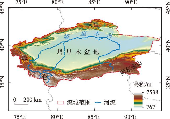
Response and influencing factors of habitat quality and land use change in the Tarim River Basin
Received date: 2024-06-13
Revised date: 2024-09-08
Online published: 2025-08-12
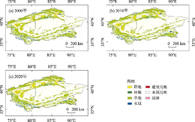
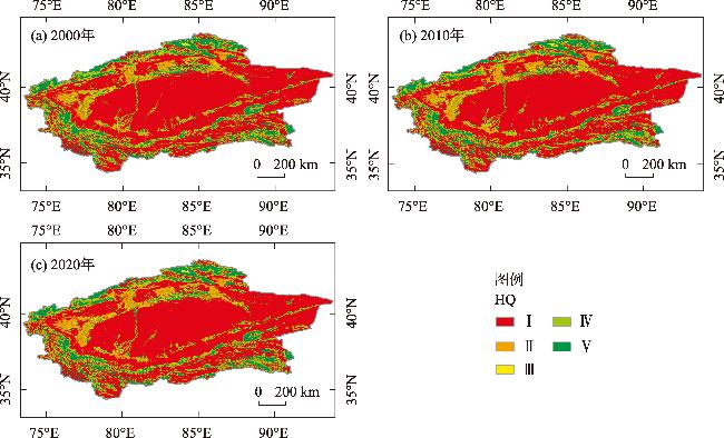
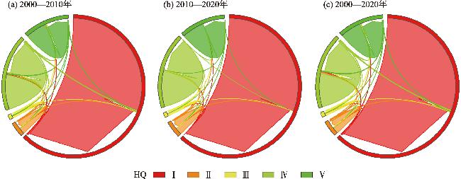
Understanding the response characteristics and influencing factors of land use change to habitat quality is essential for establishing a scientific basis for ecological protection in arid regions. In this study, we used land use data, the InVEST model, habitat contribution rate, and a geographic detector to evaluate the response and influencing factors of land use changes and habitat quality. Additionally, we predicted habitat quality for 2030. The results showed the following: (1) The land use types were dominated by unused land and grassland. The cultivated and construction land areas expanded by 10545 km2 and 1170 km2, respectively, while forest land, grassland, and unused land decreased. (2) The overall habitat quality was low and exhibited a continuous downward trend. Spatial distribution was high at the edges and low in the center. Additionally, habitat quality in grasslands adjacent to unused land decreased significantly, while overall habitat quality increased significantly. (3) The spatial distribution of habitat quality was primarily influenced by elevation, temperature, and precipitation, with the interaction between elevation and precipitation having the strongest impact on habitat quality in the watershed. (4) By 2030, the ecological protection scenario will offer significant advantages over the natural and economic development scenarios, improving habitat quality. In the future, ecological protection will primarily focus on preventing and controlling desert expansion and protecting grassland and water resources.
WANG Yang , FENG Zhuoya , XU Li , GAO Wenxin . Response and influencing factors of habitat quality and land use change in the Tarim River Basin[J]. Arid Zone Research, 2024 , 41(12) : 2132 -2142 . DOI: 10.13866/j.azr.2024.12.14
表1 数据来源Tab. 1 Data sources |
| 数据名称 | 数据来源 | 分辨率 | 预处理 |
|---|---|---|---|
| 土地利用数据 | 中国科学院资源与环境数据中心 (https://www.resdc.cn) | 1 km | 经重分类后分为耕地、草地、林地、水域、建设用地、未利用地和沼泽 |
| 社会经济数据 | 中国科学院资源与环境数据中心 (https://www.resdc.cn) | 1 km | 包括GDP和人口密度数据 |
| 月平均降水量数据 | 国家青藏高原科学数据中心 (https://data.tpdc.ac.cn/home) | 1 km | 求和后得到2000年、2010年和2020年年平均降水量 |
| 月平均温度数据 | 国家青藏高原科学数据中心 (https://data.tpdc.ac.cn/home) | 1 km | 求均值得到2000年、2010年和2020年年平均温度 |
| DEM数据 | 地理空间数据云(https://www.gscloud.cn) | 90 m | 剪裁得到研究区DEM数据 |
| 坡度数据 | - | 1 km | 利用ArcGIS坡度工具计算得到 |
| 区位数据 | 国家基础地理信息中心(https://www.ngcc.cn) | 1 km | 包括距主要公路距离和距主要河流距离数据,利用欧氏距离计算得到 |
表2 生境适宜度及敏感性参数Tab. 2 Habitat suitability and sensitivity |
| 地类名称 | 生境适宜度 | 耕地 | 建设用地 | 未利用地 |
|---|---|---|---|---|
| 耕地 | 0.35 | 0 | 0.7 | 0.45 |
| 林地 | 1 | 0.7 | 0.8 | 0.5 |
| 草地 | 0.8 | 0.65 | 0.75 | 0.7 |
| 水域 | 0.95 | 0.6 | 0.68 | 0.4 |
| 建设用地 | 0 | 0 | 0 | 0 |
| 未利用地 | 0.1 | 0.15 | 0 | 0 |
| 沼泽 | 0.4 | 0.53 | 0.5 | 0.3 |
表3 威胁因子及其胁迫强度Tab. 3 Threat factors and their stress intensities |
| 威胁因子 | 最大影响距离/km | 权重 | 衰退类型 |
|---|---|---|---|
| 耕地 | 4 | 0.6 | 线性 |
| 建设用地 | 7 | 0.7 | 指数 |
| 未利用地 | 4 | 0.4 | 线性 |
表4 塔里木河流域土地利用转移矩阵Tab. 4 Land use transition matrix in the Tarim River Basin /km2 |
| 时期 | LUCC | 耕地 | 林地 | 草地 | 水域 | 建设用地 | 未利用地 | 沼泽 |
|---|---|---|---|---|---|---|---|---|
| 2000—2010年 | 耕地 | 29169 | 397 | 1170 | 143 | 479 | 405 | 15 |
| 林地 | 873 | 10676 | 1322 | 105 | 14 | 441 | 18 | |
| 草地 | 4072 | 1240 | 264549 | 1361 | 75 | 5985 | 216 | |
| 水域 | 246 | 102 | 1566 | 23229 | 58 | 1857 | 114 | |
| 建设用地 | 419 | 15 | 18 | 6 | 1453 | 32 | 0 | |
| 未利用地 | 1087 | 435 | 6162 | 1914 | 172 | 665831 | 90 | |
| 沼泽 | 86 | 72 | 291 | 242 | 0 | 61 | 2685 | |
| 2010—2020年 | 耕地 | 35636 | 1 | 120 | 6 | 182 | 7 | 0 |
| 林地 | 261 | 12649 | 1 | 12 | 13 | 0 | 1 | |
| 草地 | 4893 | 0 | 269613 | 378 | 138 | 8 | 50 | |
| 水域 | 23 | 1 | 148 | 26664 | 1 | 3 | 160 | |
| 建设用地 | 1 | 0 | 0 | 0 | 2550 | 0 | 0 | |
| 未利用地 | 1486 | 63 | 28 | 380 | 529 | 671933 | 193 | |
| 沼泽 | 23 | 0 | 81 | 105 | 0 | 0 | 2929 | |
| 2000—2020年 | 耕地 | 29372 | 377 | 885 | 144 | 654 | 333 | 13 |
| 林地 | 1135 | 10451 | 1281 | 113 | 23 | 428 | 18 | |
| 草地 | 8471 | 1212 | 259757 | 1680 | 215 | 5927 | 236 | |
| 水域 | 281 | 98 | 1608 | 23026 | 70 | 1825 | 264 | |
| 建设用地 | 416 | 15 | 12 | 6 | 1471 | 23 | 0 | |
| 未利用地 | 2533 | 489 | 6104 | 2261 | 680 | 663355 | 269 | |
| 沼泽 | 115 | 72 | 342 | 315 | 0 | 60 | 2533 |
表6 交互作用探测结果Tab. 6 Interaction detection results |
| 影响因素 | 高程 | 坡度 | 降水 | 温度 | 人口密度 | GDP | 距主要公路距离 | 距主要河流距离 |
|---|---|---|---|---|---|---|---|---|
| 高程 | 0.1644 | |||||||
| 坡度 | 0.1870 | 0.0982 | ||||||
| 降水 | 0.2245 | 0.1810 | 0.1090 | |||||
| 温度 | 0.2050 | 0.1939 | 0.2253 | 0.1626 | ||||
| 人口密度 | 0.1877 | 0.1143 | 0.1196 | 0.1858 | 0.0061 | |||
| GDP | 0.1759 | 0.1057 | 0.1122 | 0.1734 | 0.0083 | 0.0040 | ||
| 距主要公路距离 | 0.2002 | 0.1121 | 0.1569 | 0.2039 | 0.0201 | 0.0196 | 0.0156 | |
| 距主要河流距离 | 0.1825 | 0.1067 | 0.1270 | 0.1947 | 0.0205 | 0.0164 | 0.0416 | 0.0114 |
| [1] |
袁文华, 范文君, 李建春, 等. 黄河流域典型县域生境质量的时空分异特征及影响因素研究[J]. 生态与农村环境学报, 2024, 40(5): 622-633.
[
|
| [2] |
智菲, 周振宏, 赵铭, 等. 基于InVEST和Geodetector模型的合肥生境质量时空演变及影响因素分析[J]. 河北环境工程学院学报, 2024, 34(3): 49-54.
[
|
| [3] |
|
| [4] |
|
| [5] |
王佩, 李英杰, 袁家根, 等. 基于优化MaxEnt模型的原麝生境适宜性评价[J]. 野生动物学报, 2023, 44(1): 38-45.
[
|
| [6] |
|
| [7] |
|
| [8] |
张丹华, 王洋, 幺宁. 辽中南城市群城市化及生态效应[J]. 应用生态学报, 2022, 33(9): 2521-2529.
[
|
| [9] |
|
| [10] |
|
| [11] |
张大智, 孙小银, 袁兴中, 等. 南四湖流域1980—2015年土地利用变化及其对流域生境质量的影响[J]. 湖泊科学, 2018, 30(2): 349-357.
[
|
| [12] |
赵庆建, 吴晓珍. 基于InVEST模型的岷江流域土地利用变化对生境质量的影响研究[J]. 生态科学, 2022, 41(6): 1-10.
[
|
| [13] |
魏文飞, 包玉, 王志泰, 等. 喀斯特多山城市生境质量对土地利用变化的时空响应——以贵阳市为例[J]. 生态学报, 2023, 43(10): 3920-3935.
[
|
| [14] |
韩宇, 毛逸飞, 杨伶, 等. 洞庭湖流域生境质量对LUCC的动态响应[J]. 中南林业科技大学学报, 2023, 43(6): 148-157.
[
|
| [15] |
赵依谷, 黄伟, 费秀超, 等. 基于MGWR模型的天目-怀玉山区生境质量对土地利用变化的响应[J]. 安徽农业大学学报, 2023, 50(3): 502-510.
[
|
| [16] |
杨荣钦, 肖玉磊, 池苗苗, 等. 近20 a塔里木河流域人类活动及景观生态风险时空变化[J]. 干旱区研究, 2024, 41(6): 1010-1020.
[
|
| [17] |
王璐晨, 韩海辉, 张俊, 等. 塔里木河流域土地利用及人类活动强度的时空演化特征研究[J]. 中国地质, 2024, 51(1): 203-220.
[
|
| [18] |
刘雨曈. 塔里木河流域水土流失动态变化分析[J]. 水生态学杂志, 2022, 43(3): 105-112.
[
|
| [19] |
常雪儿, 汪洋, 甄慧, 等. 1990—2018年新疆喀什噶尔河流域土地利用/覆被变化空间耦合及其生态效应[J]. 西南农业学报, 2022, 35(3): 596-607.
[
|
| [20] |
冉启云. 塔里木河流域地表水体时空变化特征探究及分析[D]. 重庆: 重庆交通大学, 2017.
[
|
| [21] |
阿里木·阿布都克然木. 人类活动影响下塔里木河流域土地利用变化与驱动力分析[J]. 水利技术监督, 2024(6): 116-120.
[
|
| [22] |
克帕也木·尔肯. 基于水资源供给条件的塔里木河流域耕地规模分析[J]. 水利技术监督, 2023(10): 129-132.
[
|
| [23] |
|
| [24] |
师君银, 马勇刚, 许仲林. 喀什地区土地利用变化对生境质量的影响[J]. 西南农业学报, 2023, 36(11): 2480-2490.
[
|
| [25] |
王晓琴, 王宏卫, 谈波, 等. 新疆阿克苏地区景观格局与生境质量时空演变及影响机制[J]. 华侨大学学报(自然科学版), 2022, 43(6): 777-789.
[
|
| [26] |
李文秀, 燕振刚. 基于地理探测器的甘肃农牧交错带土地利用时空演化及其驱动机制[J]. 干旱区研究, 2024, 41(4): 590-602.
[
|
| [27] |
李鑫磊, 李瑞平, 王秀青, 等. 基于地理探测器的河套灌区林草植被覆盖度时空变化与驱动力分析[J]. 干旱区研究, 2023, 40(4): 623-635.
[
|
| [28] |
孙晓雨, 杨金明, 张家豪, 等. 五台山风景名胜区土地利用变化及其对生境质量的影响[J]. 自然保护地, 2024, 4(2): 124-140.
[
|
| [29] |
张小瑜, 周自翔, 唐志雄, 等. 无定河流域生境质量时空变化及预测[J]. 中国沙漠, 2024, 44(3): 75-84.
[
|
| [30] |
付玮, 夏文浩, 樊童生, 等. 塔里木河流域生态系统碳储量的情景预测分析[J]. 干旱区地理, 2024, 47(4): 634-647.
[
|
| [31] |
杨顺法, 昝梅, 袁瑞联, 等. 基于 PLUS与 InVEST模型的新疆碳储量变化及预测[J/OL]. 环境科学. https://doi.org/10.13227/j.hjkx.202312272, 2024-06-12.
[
|
| [32] |
糜毅, 李涛, 吴博, 等. 基于优化模拟的长株潭3+5城市群碳储量时空演变与预测[J]. 环境工程技术学报, 2023, 13(5): 1740-1751.
[
|
| [33] |
徐梦菲, 孙一帆, 汪霞. 郑州市土地利用/覆被变化与生境质量的时空演变及情景预测[J]. 水土保持通报, 2024, 44(2): 364-377.
[
|
| [34] |
|
| [35] |
王彤, 易桂花, 张廷斌, 等. 西南三江流域生境质量时空格局及其地形梯度效应[J]. 水土保持研究, 2023, 30(5): 306-314.
[
|
| [36] |
王梓洋, 石培基, 李雪红, 等. 河西走廊地区生境质量对土地利用变化的响应机制及提升路径[J/OL]. 环境科学. https://doi.org/10.13227/j.hjkx.202312250, 2024-08-11.
[
|
| [37] |
吝静, 赵成义, 马晓飞, 等. 基于生态系统服务价值的塔里木河干流土地利用结构优化[J]. 干旱区研究, 2021, 38(4): 1140-1151.
[
|
| [38] |
杨昕馨, 赵少军. 新疆塔里木河流域生态文明建设对策建议[J]. 地下水, 2023, 45(3): 251-253.
[
|
/
| 〈 |
|
〉 |
