
Dynamic simulation of land use change and habitat quality in the Three River Source Region based on the PLUS-InVEST models
Received date: 2024-10-29
Revised date: 2024-12-16
Online published: 2025-08-12
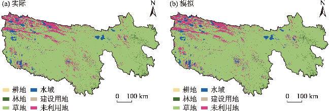
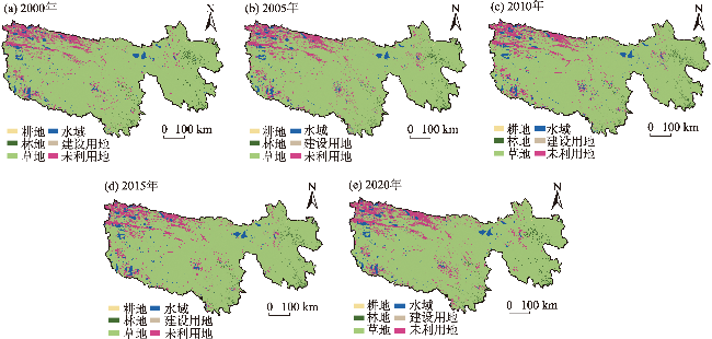
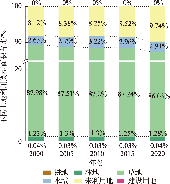
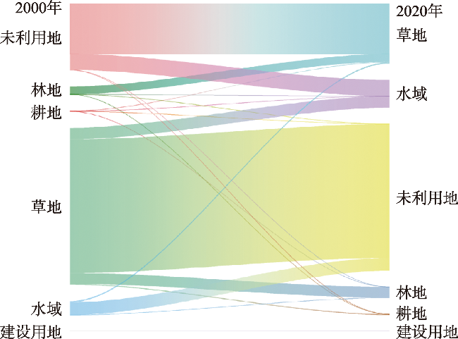
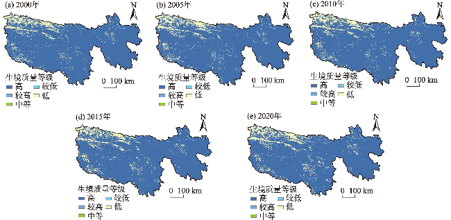
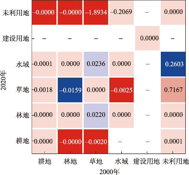
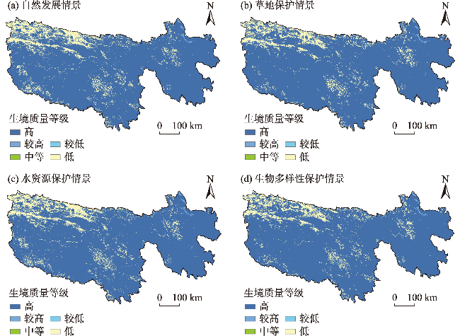
The ongoing decline in biodiversity adversely effects ecosystem services. Investigating spatiotemporal changes in land use and habitat quality in the Three River Source Region is crucial for ecological protection and restoration. This study, based on the PLUS model and the InVEST model’s habitat quality module, conducts multi-scenario simulations to predict land use changes and estimate habitat quality. The results are as follows: (1) During the historical period, 9663.53 km2 of grassland converted to unused land, represented the largest proportion of total land conversion, whereas unused land converted to grassland only covered 3659.27 km2, the grassland degraded into unused land to a relatively serious extent in the Three River Source Region. (2) Multi-scenario predictions for 2030 reveal that the biodiversity conservation scenario performs best, followed by the grassland protection scenario, then the water resources protection scenario, and finally the natural development scenario. (3) Among conversion types, the contribution rate of converting unused land to grassland in enhancing habitat quality is highest at 0.7167, followed by that of converting unused land to water bodies, at 0.2603. Implementing biodiversity protection strategies, resolving the grass-livestock conflict, and enhancing management of unused land, while reducing grassland-to-unused land conversion will help mitigate the decline in habitat quality.
LIU Xiaoming , ZHENG Shiyan , QIAO Zhanming . Dynamic simulation of land use change and habitat quality in the Three River Source Region based on the PLUS-InVEST models[J]. Arid Zone Research, 2025 , 42(6) : 1080 -1092 . DOI: 10.13866/j.azr.2025.06.11
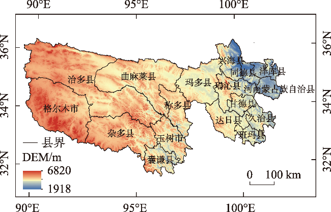
表1 数据来源Tab. 1 Data source |
| 数据类型 | 数据描述 | 分辨率/m | 数据来源 |
|---|---|---|---|
| 土地利用 | 五期土地利用数据 | 30 | 中国30 m年度土地覆盖数据集(https://zenodo.org/records/8176941) |
| 生境质量 | 胁迫源因子表 | - | 文献〔29-31〕 |
| 敏感性因子表 | - | ||
| PLUS模型中 驱动因子数据 | 人口密度 | 100 | WorldPop人口数据集(100 m)(https://www.worldpop.org/) |
| GDP | 1000 | 中国GDP空间分布公里网格数据集(https://www.resdc.cn/DOI/DOI.aspx?DOIID) | |
| 距各级国道距离(选取了三类) | 1000 | 全国地理信息资源目录服务系统(https://www.webmap.cn/commres.do?method=result100W) | |
| 距高速公路距离 | 1000 | ||
| 距居民点距离 | 1000 | ||
| 距水域距离 | 1000 | ||
| DEM | 30 | 地理空间数据云(https://www.gscloud.cn) | |
| 坡度 | 30 | 根据数字高程模型(DEM)提取 | |
| 年均气温 | 1000 | 国家青藏高原科学数据中心(https://data.tpdc.ac.cn) | |
| 年均降水 | 1000 | ||
| 年均蒸散量 | 1000 | ||
| 土壤数据 | 1000 |
表2 2030年不同发展情景下各土地利用类型邻域权重Tab. 2 Neighborhood weights of land use types under different development scenarios in 2030 |
| 发展情景 | 耕地 | 林地 | 草地 | 水域 | 建设 用地 | 未利 用地 |
|---|---|---|---|---|---|---|
| 自然发展 | 0.010 | 0.017 | 0.807 | 0.186 | 0 | 1.000 |
| 草地保护 | 0.000 | 0.021 | 1.000 | 0.273 | 0 | 0.706 |
| 水资源保护 | 0.012 | 0.020 | 1.000 | 0.118 | 0 | 0.890 |
| 生物多样性保护 | 0.008 | 0.029 | 0.870 | 0.151 | 0 | 1.000 |
表3 威胁源的权重和最大影响距离Tab. 3 Weights and maximum influence distance of threat sources |
| 胁迫因子 | 影响距离/km | 权重 | 衰减函数 |
|---|---|---|---|
| 耕地 | 3 | 0.7 | 线性 |
| 未利用地 | 1 | 0.3 | 指数 |
| 建设用地 | 10 | 1 | 指数 |
表4 土地利用对威胁因子的敏感性Tab. 4 Sensitivity of land use to threat factors |
| 土地利用类型 | 生境适应性 | 耕地 | 未利用地 | 建设用地 |
|---|---|---|---|---|
| 耕地 | 0.7 | 0.5 | 0.1 | 1.0 |
| 林地 | 1.0 | 0.7 | 0.3 | 0.9 |
| 草地 | 0.9 | 0.8 | 0.1 | 0.9 |
| 水域 | 1.0 | 0.7 | 0.1 | 0.7 |
| 建设用地 | 0.0 | 0.0 | 0.0 | 0.0 |
| 未利用地 | 0.2 | 0.2 | 0.1 | 0.2 |
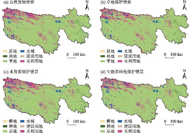
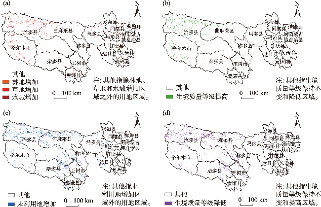
图6 2030年多情景下三江源地区土地利用空间分布Fig. 6 The spatial distribution of land use in the Three River Source Region under multiple scenarios in 2030 |
表5 2030年多情景下各土地利用类型面积和变化率Tab. 5 The area and change rate of various land use types under multiple scenarios in 2030 |
| 土地利 用类型 | 2020年 | 2030年自然发展 | 2030年草地保护 | 2030年水资源保护 | 2030年生物多样性保护 | ||||||||
|---|---|---|---|---|---|---|---|---|---|---|---|---|---|
| 面积/km2 | 面积/km2 | 变化率/% | 面积/km2 | 变化率/% | 面积/km2 | 变化率/% | 面积/km2 | 变化率/% | |||||
| 耕地 | 146.958 | 189.743 | 29.11 | 147.656 | 0.47 | 189.305 | 28.82 | 165.567 | 12.66 | ||||
| 林地 | 4584.362 | 4512.952 | -1.56 | 4518.282 | -1.44 | 4512.781 | -1.56 | 4517.212 | -1.46 | ||||
| 草地 | 307215.725 | 303770.430 | -1.12 | 310358.616 | 1.02 | 303654.253 | -1.16 | 309212.571 | 0.65 | ||||
| 水域 | 10379.237 | 9585.654 | -7.65 | 9520.966 | -8.27 | 10801.253 | 4.07 | 10725.846 | 3.34 | ||||
| 建设用地 | 0.004 | 0.004 | - | 0.004 | - | 0.004 | - | 0.004 | - | ||||
| 未利用地 | 34771.492 | 39038.994 | 12.27 | 32552.254 | -6.38 | 37940.182 | 9.11 | 32476.577 | -6.60 | ||||
| [1] |
孙颖. 人类活动对气候系统的影响——解读IPCC第六次评估报告第一工作组报告第三章[J]. 大气科学学报, 2021, 44(5): 654-657.
[
|
| [2] |
李奇, 朱建华, 肖文发. 生物多样性与生态系统服务——关系、权衡与管理[J]. 生态学报, 2019, 39(8): 2655-2666.
[
|
| [3] |
荔琢, 侯鹏, 蒋卫国, 等. 土地利用变化对生态系统服务功能的驱动效应研究——以秦岭地区自然保护区为例[J]. 北京师范大学学报(自然科学版), 2023, 59(2): 196-205.
[
|
| [4] |
刘梦园. 基于InVEST模型的河西地区碳储量与生境质量评价[D]. 兰州: 兰州大学, 2023.
[
|
| [5] |
陈妍, 乔飞, 江磊. 基于InVEST模型的土地利用格局变化对区域尺度生境质量的影响研究——以北京为例[J]. 北京大学学报(自然科学版), 2016, 52(3): 553-562.
[
|
| [6] |
|
| [7] |
孟宪红, 陈昊, 李照国, 等. 三江源区气候变化及其环境影响研究综述[J]. 高原气象, 2020, 39(6): 1133-1143.
[
|
| [8] |
|
| [9] |
|
| [10] |
|
| [11] |
|
| [12] |
|
| [13] |
王鹏, 秦思彤, 胡慧蓉. 近30 a拉萨河流域土地利用变化和生境质量的时空演变特征[J]. 干旱区研究, 2023, 40(3): 492-503.
[
|
| [14] |
刘如龙, 赵媛媛, 陈国清, 等. 内蒙古黄河流域1990—2020年生境质量评估[J]. 干旱区研究, 2024, 41(4): 674-683.
[
|
| [15] |
郭富印, 刘晓煌, 张文博, 等. 2000—2040年黄河流域(河南段)生境质量时空格局演变及驱动力分析[J]. 现代地质, 2024, 38(3): 599-611.
[
|
| [16] |
张家旗, 关小克. 坦桑尼亚土地利用的时空演变及驱动因素[J]. 水土保持通报, 2024, 44(3): 201-211.
[
|
| [17] |
杨洁, 谢保鹏, 张德罡. 黄河流域生境质量时空演变及其影响因素[J]. 中国沙漠, 2021, 41(4): 12-22.
[
|
| [18] |
王祥福, 李愿会, 王维枫, 等. 土地利用和气候变化对青海省雪豹潜在适宜生境的影响[J]. 浙江农林大学学报, 2024, 41(3): 526-534.
[
|
| [19] |
金龙如, 孙克萍, 贺红士, 等. 生境适宜度指数模型研究进展[J]. 生态学杂志, 2008, 27(5): 841-846.
[
|
| [20] |
张晓东, 武丹, 王莹, 等. 耦合InVEST与Geodetector模型的银川市生境质量时空演变特征及影响因子研究[J]. 干旱区地理, 2024, 47(7): 1242-1251.
[
|
| [21] |
刘雅雅, 李欣欣, 余向克, 等. 基于CA-Markov模型的成都市土地利用变化情景模拟及碳效应分析[J]. 国土资源科技管理, 2024, 41(2): 38-49.
[
|
| [22] |
顾汉龙, 马天骏, 钱凤魁, 等. 基于CLUE-S模型县域土地利用情景模拟与碳排放效应分析[J]. 农业工程学报, 2022, 38(9): 288-296.
[
|
| [23] |
秦埼瑞, 李雪梅, 陈庆伟, 等. 基于FLUS模型的天山山区未来土地利用变化预估[J]. 干旱区研究, 2019, 36(5): 1270-1279.
[
|
| [24] |
蒋小芳, 段翰晨, 廖杰, 等. 基于PLUS-SD耦合模型的黑河流域中游甘临高地区土地利用研究[J]. 干旱区研究, 2022, 39(4): 1246-1258.
[
|
| [25] |
许茜, 李奇, 陈懂懂, 等. 近40 a三江源地区土地利用变化动态分析及预测[J]. 干旱区研究, 2018, 35(3): 695-704.
[
|
| [26] |
|
| [27] |
张小瑜, 周自翔, 唐志雄, 等. 无定河流域生境质量时空变化及预测[J]. 中国沙漠, 2024, 44(3): 75-84.
[
|
| [28] |
邓楚雄, 郭方圆, 黄栋良, 等. 基于INVEST模型的洞庭湖区土地利用景观格局对生境质量的影响研究[J]. 生态科学, 2021, 40(2): 99-109.
[
|
| [29] |
孙晓雨, 杨金明, 张家豪, 等. 五台山风景名胜区土地利用变化及其对生境质量的影响[J]. 自然保护地, 2024, 4(2): 124-140.
[
|
| [30] |
|
| [31] |
|
| [32] |
刘智方, 唐立娜, 邱全毅, 等. 基于土地利用变化的福建省生境质量时空变化研究[J]. 生态学报, 2017, 37(13): 4538-4548.
[
|
| [33] |
杨清可, 段学军, 王磊, 等. 基于“三生空间”的土地利用转型与生态环境效应——以长江三角洲核心区为例[J]. 地理科学, 2018, 38(1): 97-106.
[
|
/
| 〈 |
|
〉 |