
Simulation of land surface temperature in complex mountainous terrain and the influence of environmental factors: A case study in Daqingshan, Inner Mongolia
Received date: 2023-12-01
Revised date: 2024-01-31
Online published: 2024-06-20
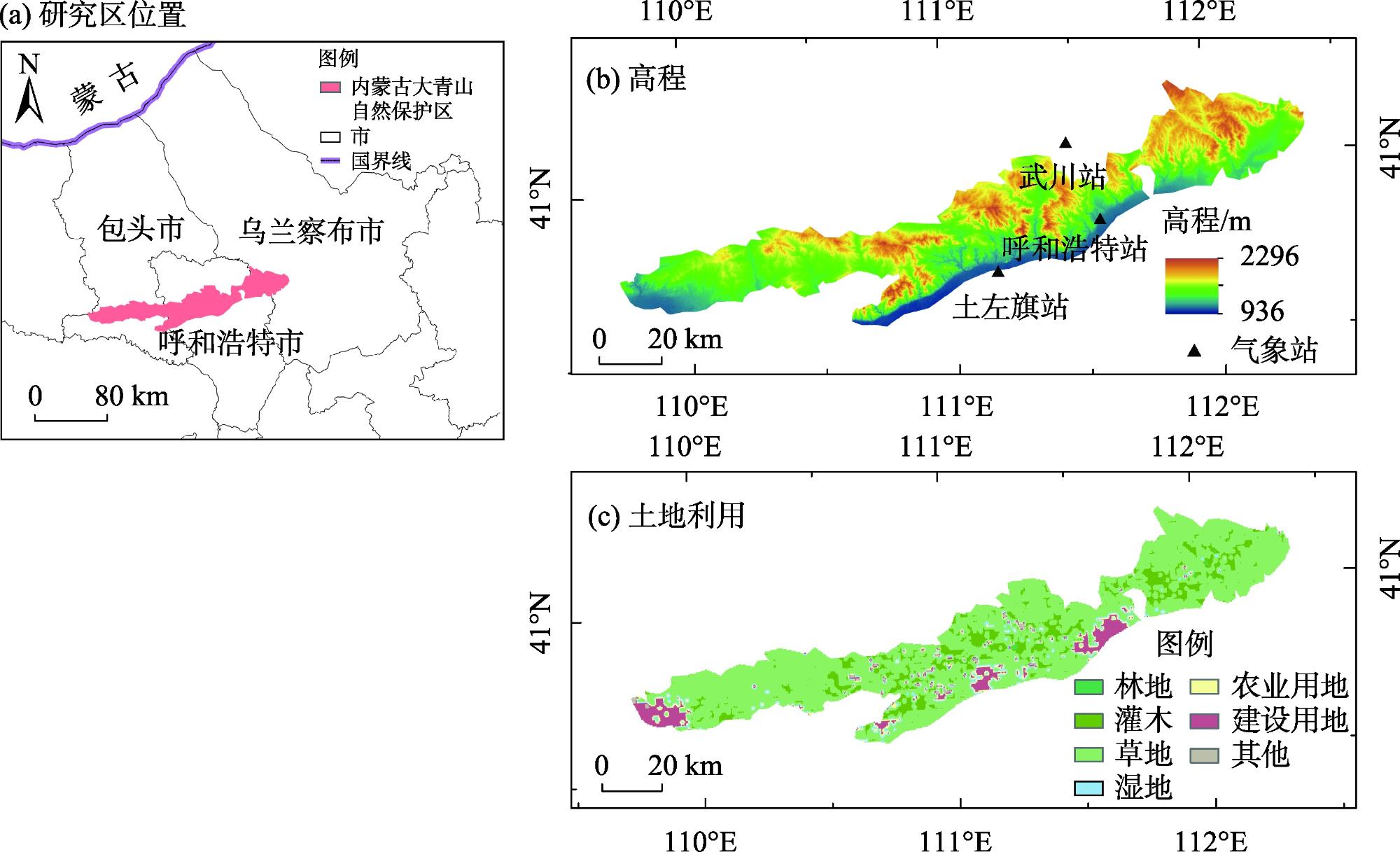
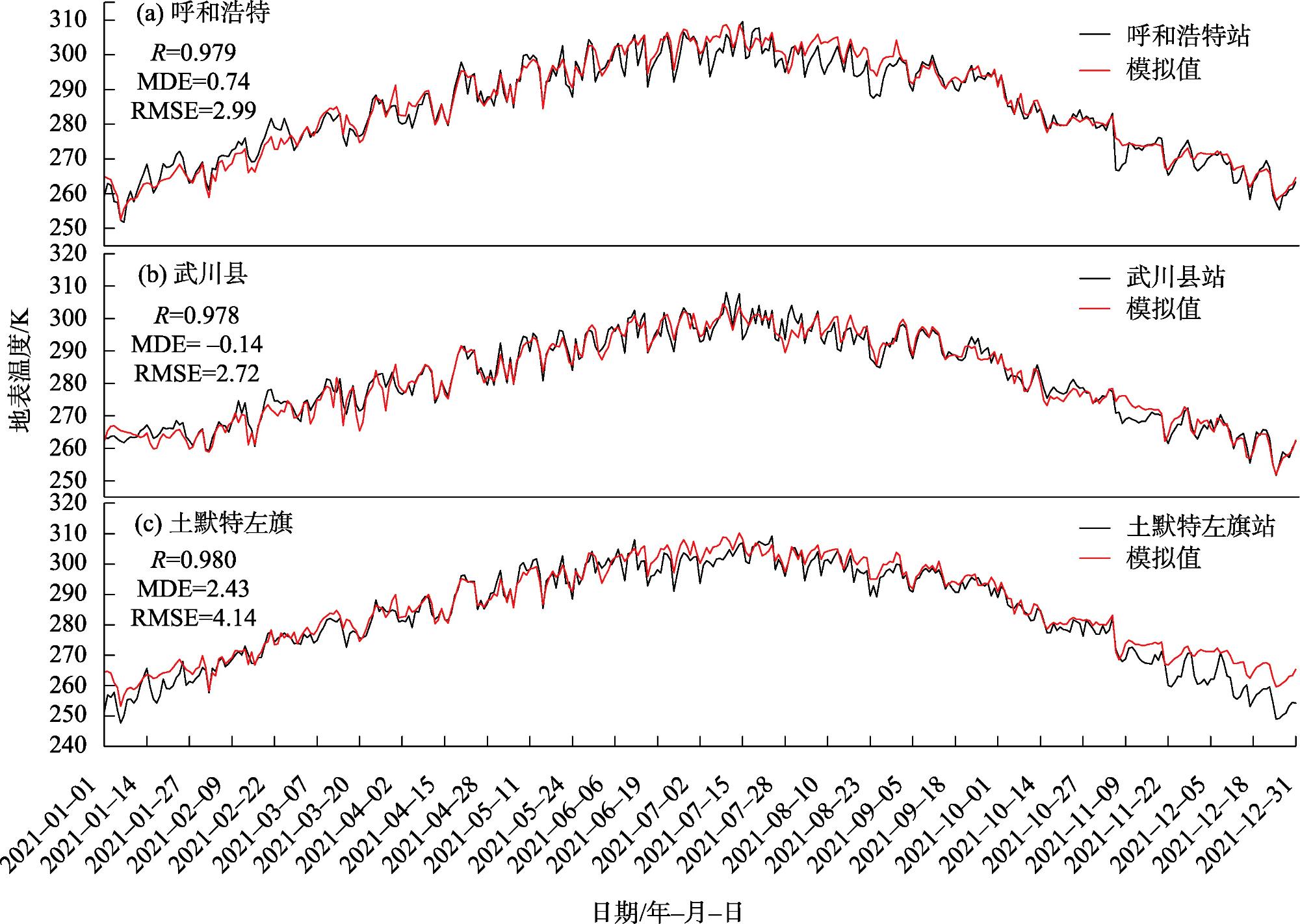
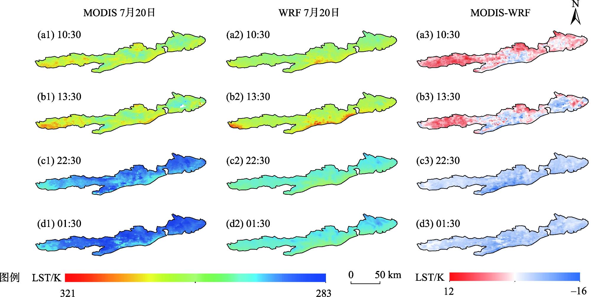
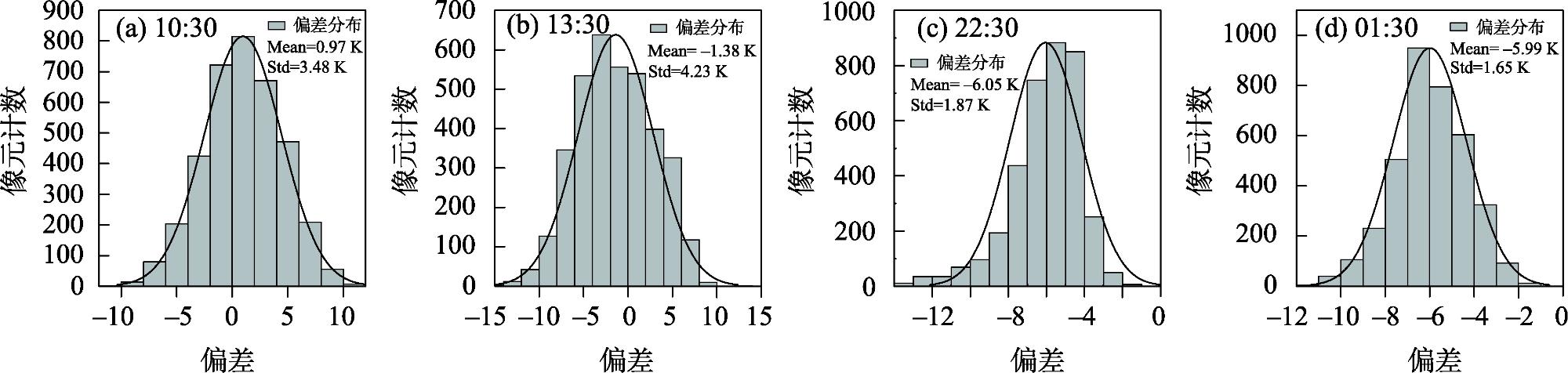
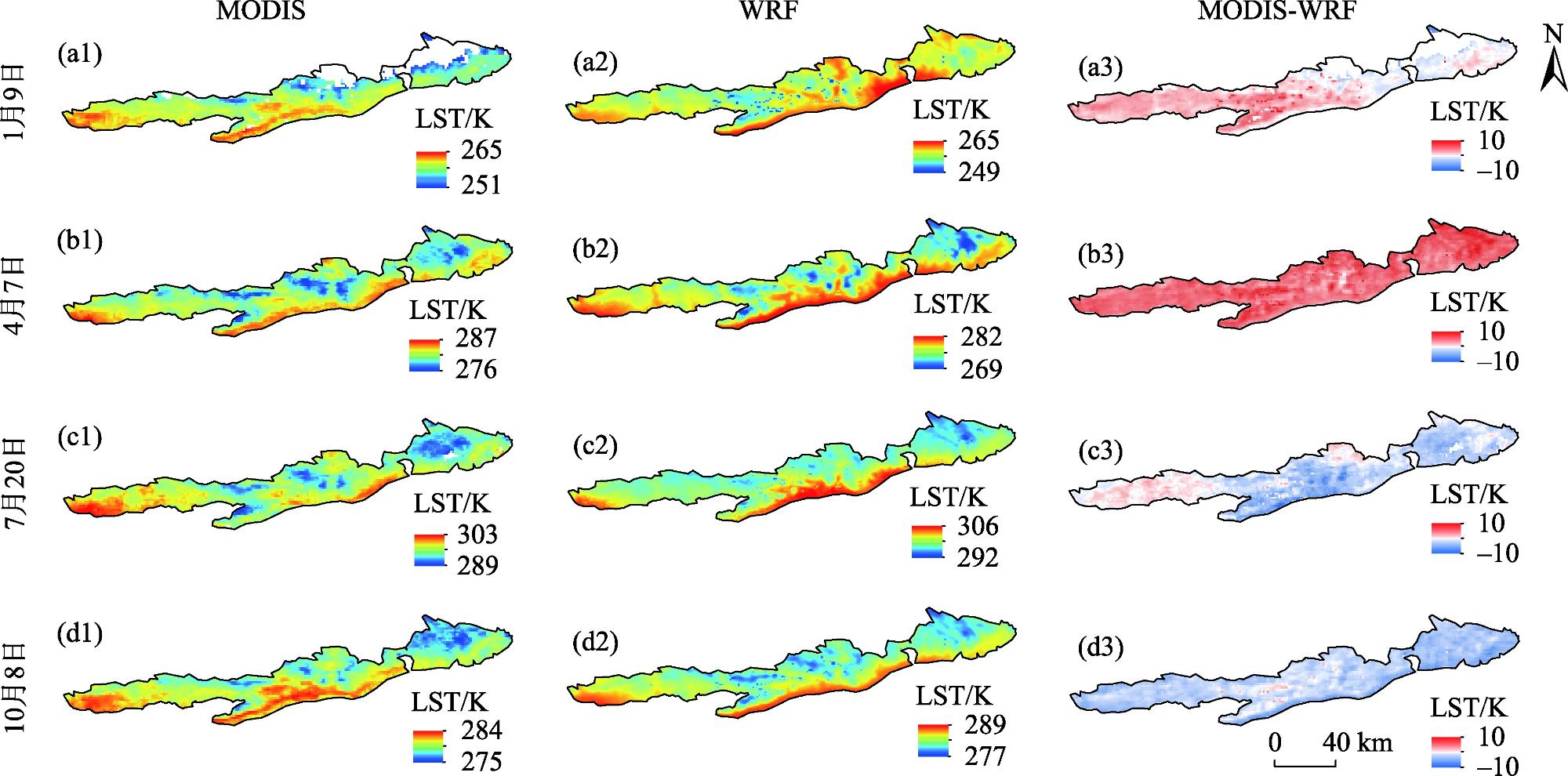
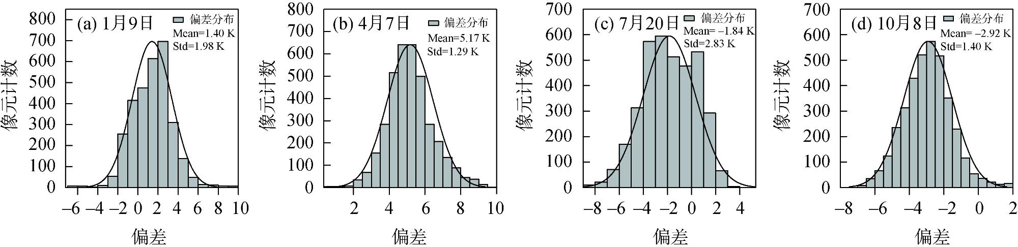
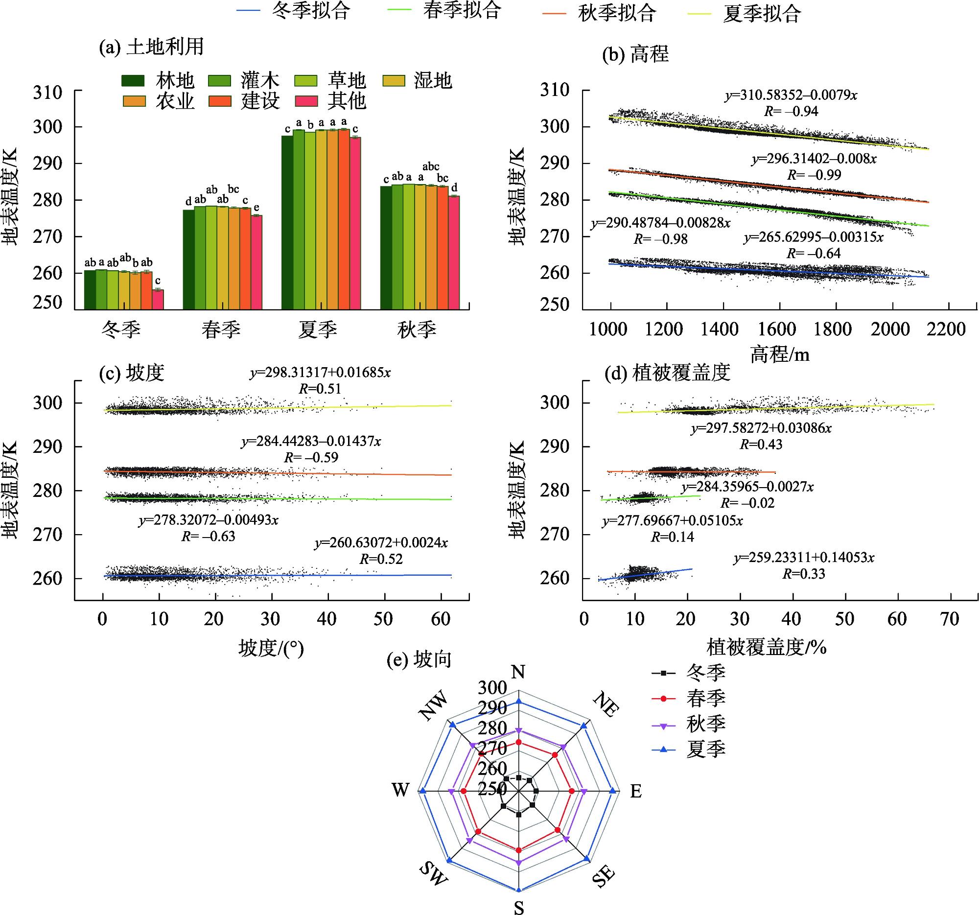
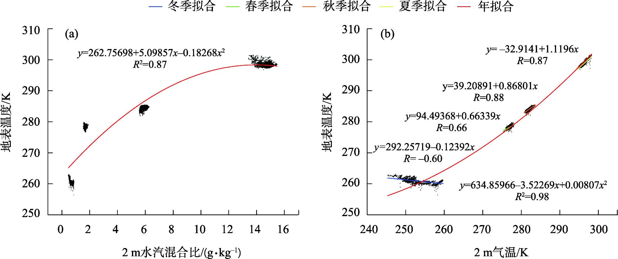
This study aimed to spatially and temporally characterize not only land surface temperature (LST) in the complex mountainous terrain of Daqingshan, Inner Mongolia but also the environmental factors affecting it. We used the Weather Research and Forecasting Mode (WRF) used to obtain LST data with high temporal and spatial resolution and analyze the variation of mountain influencing factors. The accuracy of the WRF simulated LST (WRF LST) was verified by the observation values of meteorological stations and MODIS LST values, and the relationship between LST and environmental factors was analyzed by the method of comprehensive impact factor analysis and the method of single impact factor analysis. The comprehensive impact factor analysis is based on regional WRF LST and regional environmental factors. Single impact factor analysis achieves the relationship between WRF LST and single environmental factors by fixing other environmental factors. The results revealed that the correlation coefficients between the simulated and observed values were >0.97 (P<0.001) and the spatial correlation with MODIS LST was 0.73 (P<0.05), indicating that WRF has good practicability in mountainous areas. After comprehensive impact factor analysis, it was found the annual WRF LST had the greatest correlation with elevation (R>0.97), followed by temperature at 2 m and water/air mixing ratio at 2 m (R>0.8), vegetation coverage and slope (R>0.3), and other factors. By single impact factor analysis, LST decrease rate with elevation was 0.83 K·(100m)-1, 0.79 K·(100m)-1, 0.80 K·(100m)-1 and 0.32 K·(100m)-1 in spring, summer, autumn and winter, and it increased by -0.05 K, 0.17 K, -0.14 K, and 0.02 K for every 10° increase in slope in spring, summer fall winter, respectively. LST also increased for every 10% increase in vegetation cover by 0.31 K, 1.41 K in summer and winter, and was not correlated with fall. The slope direction and average LST for the four seasons were south>southwest>southeast>west>east>northwest>northeast>north. The 2 m water-air mixing ratio increased logarithmically with LST, while the 2 m air temperature increased exponentially with LST. This study demonstrated that the WRF model can be used to simulate the spatial and temporal distribution of LST in mountainous terrain and analyze the LST relationship in complex mountain environments.
ZHAO Lichao , ZHANG Chengfu , HE Shuai , MIAO Lin , FENG Shuang , PAN Sihan . Simulation of land surface temperature in complex mountainous terrain and the influence of environmental factors: A case study in Daqingshan, Inner Mongolia[J]. Arid Zone Research, 2024 , 41(5) : 765 -775 . DOI: 10.13866/j.azr.2024.05.05
表2 各环境因子设定值Tab. 2 Fixed values for each environmental factor |
| 特征变量 | 设定值 |
|---|---|
| 高程/m | 1400~1600 |
| 坡度/(°) | 0~20 |
| 坡向/(°) | 157.5~202.5(南) |
| 植被覆盖/% | 10~30 |
| 土地利用 | 草地 |
表3 2020—2021年环境因子与LST的相关分析Tab. 3 Correlation analysis of environmental factors and LST in 2020-2021 |
| 地表温度 | 2 m气温 | 2 m水汽混合比 | 植被覆盖度 | 高程 | 坡度 |
|---|---|---|---|---|---|
| 春季平均 | 0.97** | 0.60** | -0.33** | -0.97** | -0.29** |
| 夏季平均 | 0.96** | 0.65** | -0.27** | -0.92** | -0.25** |
| 秋季平均 | 0.98** | 0.70** | -0.25** | -0.98** | -0.32** |
| 冬季平均 | 0.12** | 0.03** | 0.08** | -0.62** | -0.27** |
| 年平均 | 0.87** | 0.81** | -0.32** | -0.97** | -0.30** |
注:**代表相关性显著。3—5月为春季;6—8月为夏季;9—11月为秋季;12月—次年2月为冬季。 |
图7 地貌因子对不同季节的地表温度作用规律Fig. 7 The effect of geomorphic factors on land surface temperature in different seasons |
| [1] |
宋海燕. CLM5. 0对东北地区地表温度的数值模拟及评估[J]. 哈尔滨师范大学自然科学学报, 2021, 37(2): 90-94.
[
|
| [2] |
|
| [3] |
|
| [4] |
|
| [5] |
|
| [6] |
|
| [7] |
|
| [8] |
|
| [9] |
屠妮妮, 何光碧, 张利红. WRF模式中不同积云对流参数化方案对比试验[J]. 高原山地气象研究, 2011, 31(2): 18-25.
[
|
| [10] |
|
| [11] |
|
| [12] |
王雪莹, 谷黄河, 代斌, 等. 不同水平分辨率区域气候模式对青藏高原气候特征模拟[J]. 干旱区研究, 2024, 41(3): 363-374.
[
|
| [13] |
张祎. 长江流域土地利用/覆被变化对地表温度的影响[D]. 武汉: 中国地质大学, 2018.
[
|
| [14] |
|
| [15] |
王明娜, 韩哲, 张庆云. 21世纪初中国北方半干旱区土地利用变化对地表温度的影响[J]. 气候与环境研究, 2016, 21(1): 65-77.
[
|
| [16] |
杜皓阳, 胡琪, 张弛, 等. 哈密绿洲土地利用变化对区域环境的影响[J]. 干旱区研究, 2018, 35(3): 568-578.
[
|
| [17] |
肖尧, 马明国, 闻建光, 等. 复杂地表地表温度反演研究进展[J]. 遥感技术与应用, 2021, 36(1): 33-43.
[
|
| [18] |
胡尔查, 王晓江, 铁牛, 等. 内蒙古大青山国家级自然保护区植被归一化指数时空变化及其与环境因子的关系[J]. 生态学报, 2022, 42(14): 5945-5955.
[
|
| [19] |
Thompson, Gregory, Field, et al. Explicit forecasts of winter precipitation using an improved bulk microphysics scheme. Part II: Implementation of a new snow parameterization[J]. Monthly Weather Review, 2008, 136, (12): 5095-5115.
|
| [20] |
|
| [21] |
|
| [22] |
|
| [23] |
Lawrence,
|
| [24] |
|
| [25] |
王澄海, 孙超. 一个基于WRF+CLM区域气候模式(WRFC)的建立及初步试验[J]. 高原气象, 2013, 32(6): 1626-1637.
[
|
| [26] |
张小培, 银燕. 复杂地形地区WRF模式四种边界层参数化方案的评估[J]. 大气科学学报, 2013, 36(1): 68-76.
[
|
| [27] |
|
| [28] |
曹明奎, 李克让. 陆地生态系统与气候相互作用的研究进展[J]. 地球科学进展, 2000, 15(4): 446-452.
[
|
| [29] |
刘祯, 曾燕, 邱新法, 等. 基于MODIS LST的0 cm地温空间扩展研究[J]. 气象科学, 2014, 34(1): 10-16.
[
|
| [30] |
任余龙, 李振朝, 蒋俊霞, 等. 三种土壤导热率模型对中国北方地表温度的模拟[J]. 高原气象, 2022, 41(5): 1315-1324.
[
|
| [31] |
李斌, 王慧敏, 秦明周, 等. NDVI、NDMI与地表温度关系的对比研究[J]. 地理科学进展, 2017, 36(5): 585-596.
[
|
| [32] |
罗瑶, 彭文甫, 董永波, 等. 基于地理探测器下的川西高原地表温度空间格局及影响因子分析——以西昌市为例[J]. 干旱区地理, 2020, 43(3): 738-749.
[
|
| [33] |
焦欢, 丁忆, 段松江, 等. 三峡库区植被覆盖度与地表温度的空间耦合季节分异研究[J]. 生态与农村环境学报, 2022, 38(12): 1604-1612.
[
|
/
| 〈 |
|
〉 |