
Distribution pattern and causes of glaciers in the Tibetan Plateau based on terrain gradient
Received date: 2023-06-09
Revised date: 2023-11-06
Online published: 2024-06-20
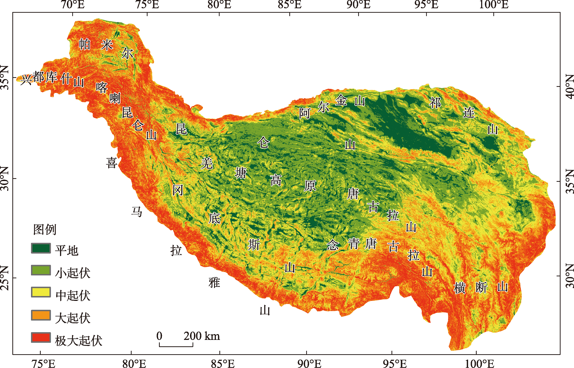
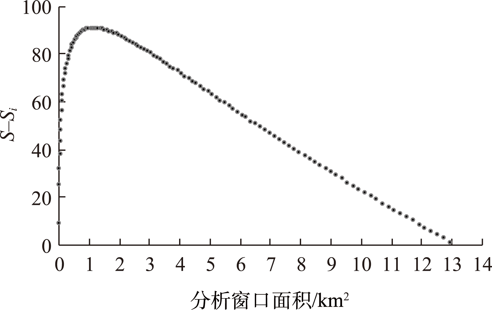
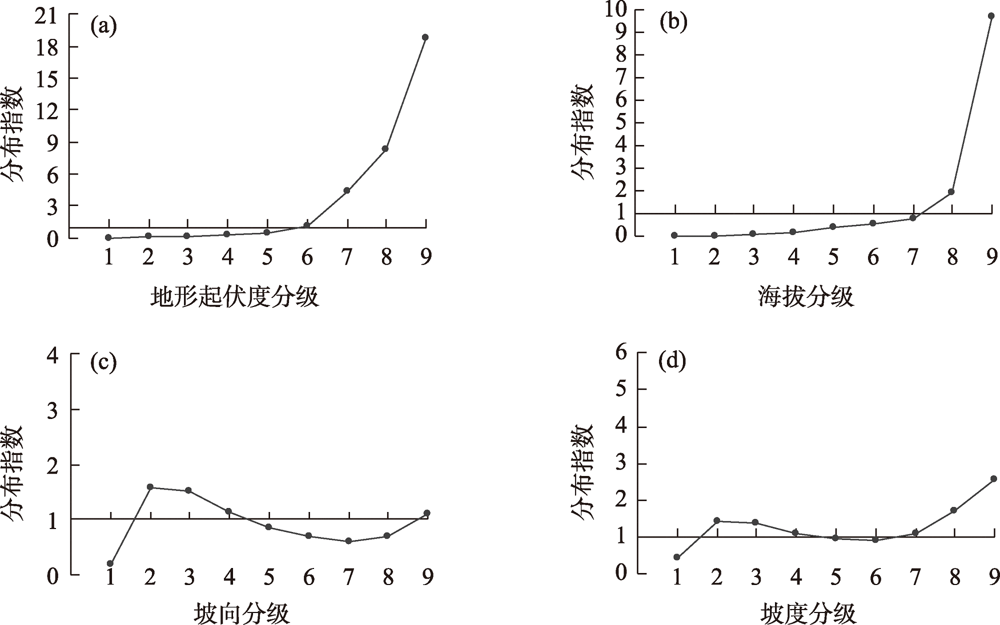
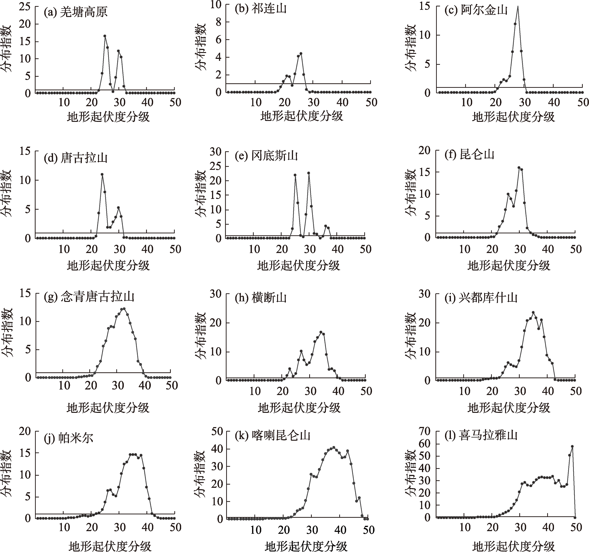
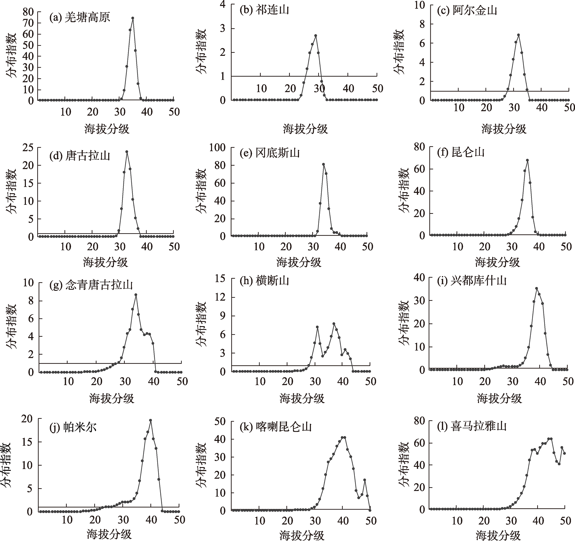
The formation and development of glaciers depend on a combination of topographic conditions and climatic factors, such as precipitation and temperature. However, the mechanisms underlying glacier distribution and variation remain uncertain. Our study aims to explore the relationship between glacier distribution patterns and topographical factors and uncover the driving forces behind them. To accomplish this, we utilized the Randolph Glacier Inventory version 6 and NASADEM for our analysis. Initially, we derived four key topographical factors based on NASADEM: relief degree of land surface (RDLS), altitude, slope, and aspect. Because the calculation of RDLS has scale dependence, the key is to determine the optimal analysis window using the average change-point analysis approach. The identified optimal analysis window size for RDLS evaluation in the study area was a rectangular neighborhood of 36 × 36 pixels, corresponding to an area of approximately 1.17 km2. Subsequently, we examined glacier distribution patterns across various terrains in the Tibetan Plateau using the distribution index. This index elucidates the disparities between actual and standard glacier distributions across various mountain chains, excluding area disturbances. Finally, we employed the geodetector method to quantitatively assess the spatial interplay between glacier distribution patterns and topographical elements. This innovative statistical approach identifies spatially stratified heterogeneity, pinpoints explanatory factors, and evaluates interactive relationships between variables. The results show that: (1) Glacier distribution in the Tibetan Plateau shows strong selectivity for RDLS and altitude, with wide suitability for aspect and slope. The predominant distribution involves large RDLS and high altitudes. (2) Topography significantly influences glacier development, with varied effects of topographic factors on the spatial distribution of glaciers. Altitude and RDLS emerged as dominant factors controlling the distribution of glaciers, followed by slope and aspect. The interactive detection revealed that the combined effect of altitude and RDLS had a dominant impact on spatially stratified glacier heterogeneity. (3) Among altitude and RDLS gradients, the Himalayas Mountains had the most extensive glacier distribution, followed by the Karakoram Mountains. The other ten mountain ranges demonstrated diverse glacier distributions, though they mostly adhered to a normal pattern. This study will serve as a theoretical reference and provide data support for regional hydrology research. It offers vital guidance for appropriate water resource management in arid lands.
XU Ning , LI Zhiguo , LIANG Xueyue , ZHOU Xiaoying . Distribution pattern and causes of glaciers in the Tibetan Plateau based on terrain gradient[J]. Arid Zone Research, 2024 , 41(2) : 230 -239 . DOI: 10.13866/j.azr.2024.02.06
表1 地形因子对冰川分布的影响Tab. 1 Influence of topographic factors on glacier distribution |
| 因子探测q值 | 交互探测 | ||||||||||
|---|---|---|---|---|---|---|---|---|---|---|---|
| 海拔 | 地形起 伏度 | 坡度 | 坡向 | 海拔∩坡向 | 海拔∩坡度 | 坡向∩坡度 | 海拔∩地形起伏度 | 坡向∩地形起伏度 | 海拔∩地形起伏度 | ||
| 阿尔金山 | 0.5901 | 0.3296 | 0.0158 | 0.0172 | 0.6651 | 0.6258 | 0.1082 | 0.6221 | 0.4106 | 0.4834 | |
| 祁连山 | 0.5205 | 0.2006 | 0.0046 | 0.0123 | 0.5480 | 0.5359 | 0.0343 | 0.5596 | 0.2277 | 0.2792 | |
| 唐古拉山 | 0.4717 | 0.2658 | 0.0017 | 0.0028 | 0.4794 | 0.5236 | 0.0162 | 0.6128 | 0.2770 | 0.4488 | |
| 昆仑山 | 0.4346 | 0.2242 | 0.0128 | 0.0070 | 0.4498 | 0.4756 | 0.0252 | 0.4610 | 0.2397 | 0.4007 | |
| 兴都库什山 | 0.3885 | 0.2045 | 0.0454 | 0.0108 | 0.4077 | 0.4451 | 0.0657 | 0.4326 | 0.2216 | 0.2951 | |
| 帕米尔 | 0.3445 | 0.2319 | 0.0279 | 0.0105 | 0.3632 | 0.3920 | 0.0448 | 0.3815 | 0.2496 | 0.3109 | |
| 横断山 | 0.2400 | 0.1328 | 0.0152 | 0.0056 | 0.2507 | 0.2631 | 0.0342 | 0.2829 | 0.1511 | 0.1865 | |
| 羌塘高原 | 0.1851 | 0.2220 | 0.0093 | 0.0044 | 0.1920 | 0.2568 | 0.0237 | 0.2428 | 0.2325 | 0.3218 | |
| 喜马拉雅山 | 0.1720 | 0.1256 | 0.0422 | 0.0039 | 0.1768 | 0.2115 | 0.0485 | 0.2150 | 0.1330 | 0.1979 | |
| 喀喇昆仑山 | 0.1593 | 0.1508 | 0.0475 | 0.0053 | 0.1668 | 0.2475 | 0.0564 | 0.2493 | 0.1612 | 0.2520 | |
| 念青唐古拉山 | 0.1201 | 0.0915 | 0.0202 | 0.0028 | 0.1258 | 0.1556 | 0.0290 | 0.1733 | 0.0989 | 0.1357 | |
| 冈底斯山 | 0.0673 | 0.0992 | 0.0119 | 0.0019 | 0.0698 | 0.0811 | 0.0286 | 0.1170 | 0.1082 | 0.1213 | |
| [1] |
刘时银, 姚晓军, 郭万钦, 等. 基于第二次冰川编目的中国冰川现状[J]. 地理学报, 2015, 70(1): 3-16.
[
|
| [2] |
姚檀栋, 陈发虎, 崔鹏, 等. 从青藏高原到第三极和泛第三极[J]. 中国科学院院刊, 2017, 32(9): 924-931.
[
|
| [3] |
|
| [4] |
冀琴, 董军, 刘睿, 等. 1990—2015年喜马拉雅山冰川变化的遥感监测及动因分析[J]. 地理科学, 2020, 40(3): 486-496.
[
|
| [5] |
施雅风. 中国冰川与环境:现在、过去和未来[M]. 北京: 科学出版社, 2000.
[
|
| [6] |
孙永, 易朝路, 刘金花, 等. 昆仑山木孜塔格地区冰川发育水汽来源探讨[J]. 地球环境学报, 2018, 9(4): 383-391.
[
|
| [7] |
吴坤鹏, 刘时银, 郭万钦. 1980—2015年南迦巴瓦峰地区冰川变化及其对气候变化的响应[J]. 冰川冻土, 2020, 42(4): 1115-1125.
[
|
| [8] |
王盛, 姚檀栋, 蒲健辰. 祁连山七一冰川物质平衡的时空变化特征[J]. 自然资源学报, 2020, 35(2): 399-412.
[
|
| [9] |
|
| [10] |
张正勇, 刘琳, 徐丽萍. 冰川分布格局对地理因子响应机制[J]. 生态环境学报, 2018, 27(2): 290-296.
[
|
| [11] |
张鲜鹤, 王欣, 刘时银, 等. 基于第二次冰川编目数据的中国冰川高度结构特征分析[J]. 地理学报, 2017, 72(3): 397-406.
[
|
| [12] |
周远刚, 赵锐锋, 张丽华, 等. 博格达峰地区冰川和积雪变化遥感监测及影响因素分析[J]. 干旱区地理, 2019, 42(6): 169-177.
[
|
| [13] |
黄丹妮, 张震, 张莎莎, 等. 东帕米尔高原冰川运动特征分析[J]. 干旱区地理, 2021, 44(1): 131-140.
[
|
| [14] |
张廉卿, 许向科, 张骞, 等. 念青唐古拉山西段小冰期以来冰川变化[J]. 地球环境学报, 2019, 10(6): 567-578.
[
|
| [15] |
李林凤, 李开明. 石羊河流域冰川变化与地形因子的关系探究[J]. 冰川冻土, 2019, 41(5): 1026-1035.
[
|
| [16] |
封志明, 李文君, 李鹏, 等. 青藏高原地形起伏度及其地理意义[J]. 地理学报, 2020, 75(7): 1359-1372.
[
|
| [17] |
王劲峰, 徐成东. 地理探测器:原理与展望[J]. 地理学报, 2017, 72(1): 116-134.
[
|
| [18] |
|
| [19] |
|
| [20] |
牟建新, 李忠勤, 张慧, 等. 全球冰川面积现状及近期变化—基于2017年发布的第6版Randolph冰川编目[J]. 冰川冻土, 2018, 40(2): 238-248.
[
|
| [21] |
|
| [22] |
|
| [23] |
|
| [24] |
宿星, 魏万鸿, 郭万钦, 等. 基于SRTM DEM的地形起伏度对天水市黄土滑坡的影响分析[J]. 冰川冻土, 2017, 39(3): 616-622.
[
|
| [25] |
喻红, 曾辉, 江子瀛. 快速城市化地区景观组分在地形梯度上的分布特征研究[J]. 地理科学, 2001, 21(1): 64-69.
[
|
| [26] |
|
| [27] |
|
| [28] |
杨勤业, 郑度. 冈底斯山-念青唐古拉山线自然地理意义的探讨[J]. 地理研究, 1985, 4(2): 36-44.
[
|
/
| 〈 |
|
〉 |