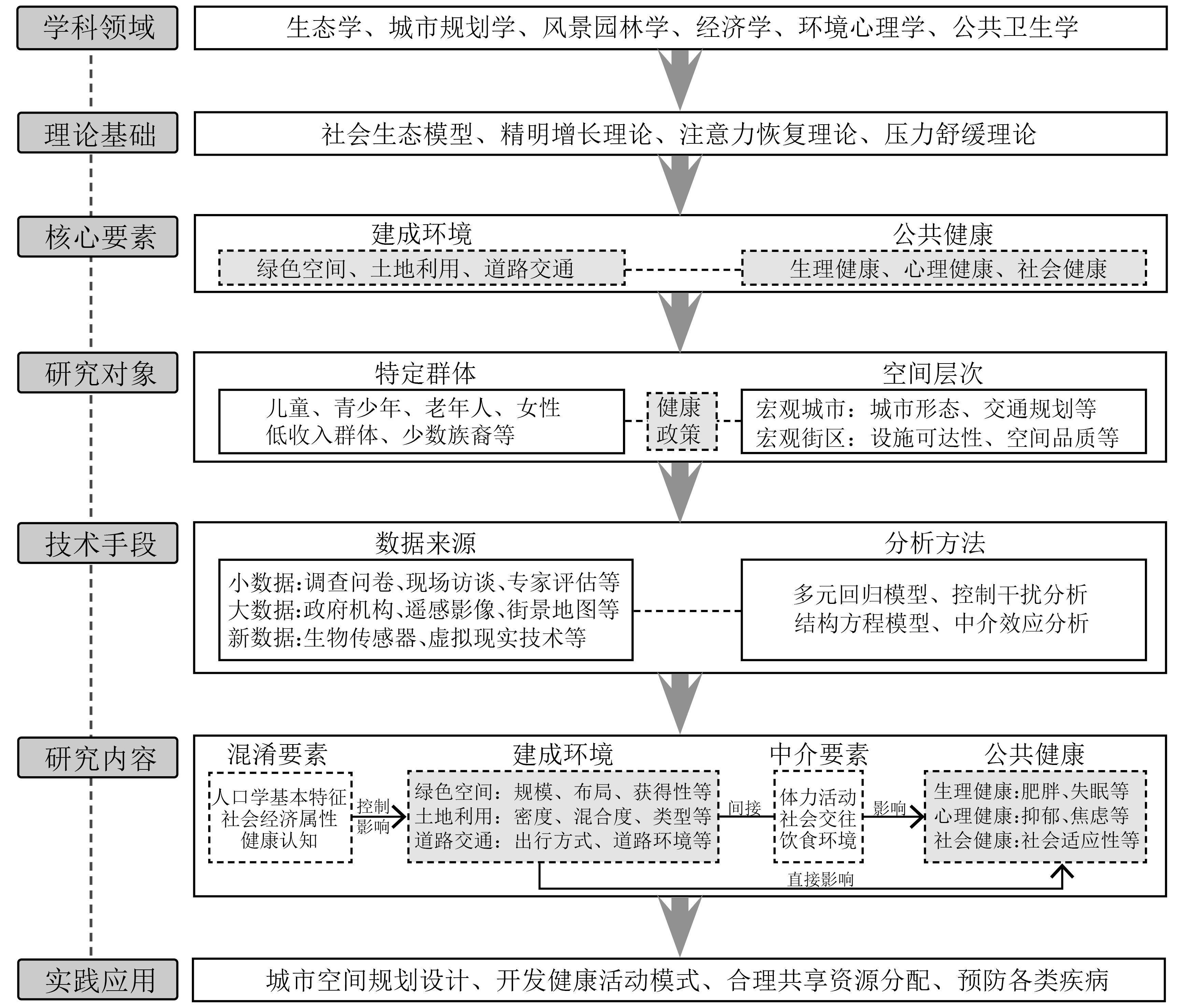
Built environments have complex effects on the public's physical and mental health. Revealing the mechanisms and pathways through which the urban built environment influences public health can provide a basis for optimizing built environments. This helps avoid issues, such as environmental pollution, lack of social interaction, and insufficient physical activity, ultimately contributing to the enhancement of public health. Western academia has a more established foundation for research, whereas domestic endeavors are currently in the exploratory phase. A comparative analysis of relevant domestic and international studies can help elucidate the developmental trajectory of research in this field, identify common issues and characteristics, and guide the direction for advancing domestic research. Therefore, based on the Web of Science and China National Knowledge Infrastructure databases, this study systematically reviewed 658 English and Chinese studies published from 2000 to 2022 in the fields of urban and rural planning, geographic sciences, health medicine, and environmental psychology, focusing on the impact of the built environment on public health. Utilizing "Citespace" software, this study conducted a quantitative analysis and systematic review of the theoretical framework, study topics, and emerging trends in the research. The findings revealed disparities between Western and Chinese academies in terms of theoretical innovation, study groups, and research content. Specifically, international studies have pioneered theoretical perspectives, such as social welfare and environmental justice. Guided by these theories, researchers have explored the mechanisms through which the built environment affects public health in diverse population groups. Although domestic studies exhibit a relative lack of theoretical innovation, their primary focus has been the introduction and empirical application of Western theories in the Chinese context. These studies often concentrate on the transmission paths of the impacts on the older and women groups through static empirical evidence, lacking dynamism in their approaches. Furthermore, drawing upon the previously stated theoretical underpinnings, methodological approach, and research content, this paper summarized the analytical framework of "Built Environment Elements, Mediated Impacts, and Public Health." It meticulously examined the differential effects of three spatial elements—green space, land use, and road traffic—on public health. This study provides a detailed analysis of the mechanisms involved, highlighting the ecological and psychological benefits arising from exposure to and interactions with green spaces. It also analyzes how judiciously designed and compact land use patterns shape travel preferences, reduce travel distances, mitigate reliance on motor vehicles, and enhance the frequency of individual activities. Furthermore, the study outlines the ramifications for optimizing the road network system and transitioning travel modes to ameliorate traffic pollution, alleviate traffic pressure, and mitigate pedestrian injuries, among other variables. The purpose of this study was to systematically comprehend the current status and disparities in domestic and international research concerning the impact of the built environment on public health and to explore a series of health issues triggered by the built environment from the perspective of urban planning, with the hope of promoting health geography in China, offering guidance for future academic directions, and prompting local management authorities to formulate precision policies addressing public health challenges.
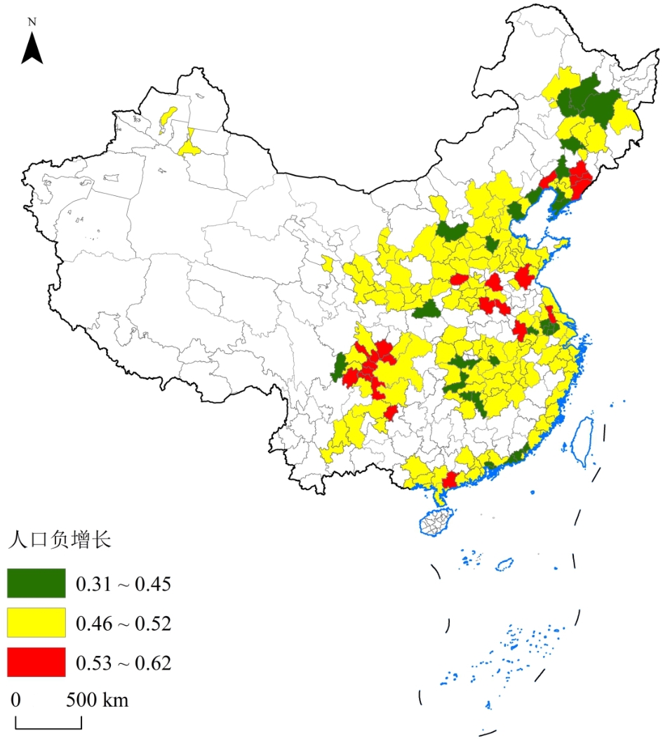
China is currently entering a stage of high-quality development, with urban development and governance facing systematic reconstruction of internal and external conditions, showing clear differences and the complex superposition of multi-stage development. The steady progress of urbanization has facilitated significant changes in the population structure of Chinese cities. It is expected that the population and industries will further converge to urban agglomerations and big cities, indicating basic multicenter and network patterns. Therefore, analyzing the negative population growth risks of urban agglomerations at different development stages is crucial. This study examined the cities of 19 urban agglomerations in China by adopting the data of the seventh population census, employing the optimized fuzzy logic method, building a complex network of population flow with ArcGIS and MATLAB platforms, and using the intensity of population flow and the registered population fertility rate to represent exogenous and endogenous growth, respectively. The negative population growth evaluation index system was constructed with five indicators: child ratio, aging rate, average family size, population density, and sex ratio. The risk index of negative population growth was measured using the fuzzy logic method, and the growth mechanism of negative population growth risk in urban agglomerations in China was analyzed using the spatial measurement method. (1) The negative population growth risk of growing urban agglomerations was influenced by both exogenous and endogenous growth, with exogenous growth having a greater impact. (2) The dynamic mechanism of negative population growth risk in large urban agglomerations is exogenous growth, whereas that of nurturing urban agglomerations is endogenous growth. (3) According to the risk of negative population growth in China's urban agglomerations and its influencing factors, negative population growth in 19 urban agglomerations can be divided into eight types. 1) The state of population growth of expanding urban agglomerations can be divided into two types, with the middle reaches of the Yangtze River and Chengdu-Chongqing urban agglomerations as one type; the capital city has a low risk of negative population growth, while other cities have a high risk of negative population growth. The Yangtze River Delta, Pearl River Delta, and Beijing-Tianjin-Hebei city clusters are the same, with the capital and other cities having a relatively low risk of negative population growth. 2) The status of large urban agglomerations can be divided into two types: Shandong Peninsula, Central Plains, Guanzhong Plain, and Beibu Gulf urban agglomerations. The capital city has a low risk of negative population growth, whereas other cities have a high risk of negative population growth. The risk of negative population growth in capital cities and other cities is relatively low. 3) The state of population growth of cultivated urban agglomerations can be divided into four types: the Harbin and Changsha urban agglomerations and the central and southern Liaoning urban agglomerations, which have a high risk of negative population growth. Meanwhile, the northern slope of the Tianshan Mountain City cluster and the Hubao Eyu City cluster have low risk of negative population growth. The risk of negative population growth is low in the provincial capital city and high in the other cities, while endogenous growth is positive in the provincial capital city and negative in the other cities. In the Jinzhong City, Central Guizhou City, and Central Yunnan City groups, the risk of negative population growth is low in provincial cities and high in other cities. Endogenous growth shows that the capital city and other cities have positive growth. In conclusion, this study posits that upgrading urban agglomerations should consider the spatial balance of population distribution, large urban agglomerations should fulfill their role in "blocking the flow" of big cities, and nurturing urban agglomerations should "consolidate human capital." This study presents a comprehensive and in-depth analysis of the negative population growth risk and its impact mechanisms in different development stages of urban agglomerations. This can provide a decision-making reference for the formulation of scientific and reasonable population and economic policies in various urban agglomerations and plays a significant role for maintaining a long-term stable population, economy, and social growth in the region.
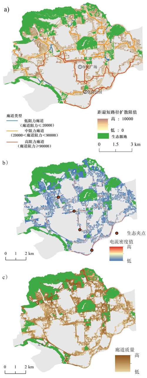
High-intensity land use and fragmented habitats are becoming more prevalent with urbanization, thereby accelerating the demand for maintaining and improving the ecological connectivity of habitat patches in high-density built-up areas. Previous studies have shown that small dispersed patches are crucial for enhancing connectivity across an entire landscape. However, as an important component of urban green space, residential green space in high-density built-up areas is often overlooked in ecological connectivity analysis. Taking Futian district, Shenzhen, as a case study, we explored the ecological connectivity in high-density built-up areas considering not only habitat patches but also green areas in residential quarters. We identified ecological patches and green areas in the residential areas of the study area. This was followed by a functional connectivity analysis under different scenarios. Several protection suggestions for improving ecological connectivity have been proposed based on functional connectivity analyses under different scenarios. The results show: 1) The area of residential green space in Futian district is 3.86 km2, covering 26.9% of the total green space in the study area, with the western part being sparser than other regions. The total area of the ecological patches was 14.34 km2, and the importance of the patches was not consistent with their size. The ecological connectivity of Lianhuashan Park in the central region, Lichi Park in the eastern region, and Huanggang Park in the southern region is greatly affected by the contiguous or continuously distributed strips of residential green space around them. 2) Residential green spaces affect eco-connectivity primarily by lowering corridor resistance, creating connectors for regions that require protection, and supporting biological flow. In particular, it had the largest effect on middle-resistance corridors (the unit cost distance was reduced by 29.2%) and alleviated the situation of pinch points formed in narrow low-resistance channels in high-density built-up areas. 3) The ecological pinch points that recurred in the ecological network under different scenarios of connecting residential green spaces and different resistance thresholds were identified as the most valuable primary pinch points for protection. It is recommended to strengthen the intersection of Xinzhou Road and Fumin Road and prioritize the protection of residential green spaces located near the ecological patches and on the topological connection between the ecological patches, with a scale exceeding the average size of 5,920.22 m2. Through the analysis of pinch points in various scenarios, it was found that 21 pinch points, including those close to Lianhuashan Park, could be used as substitute green spaces for urban renewal projects when nearby residential green spaces are destroyed or occupied. This supports the preservation of functional connectivity in urban renewal projects. It is increasingly difficult to construct significant habitat patches in high-density built-up areas to compensate for habitat fractures. The results identified the significant location and proportion of residential green spaces as critical bio-flow carriers in Futian District. These findings could encourage more comprehensive urban conservation plans that incorporate both sizable habitat patches and residential green spaces. These findings can be used to create more effective sustainable development plans that encourage biodiversity in urban renewal planning.
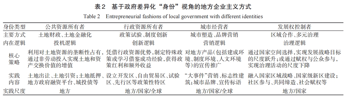
Local entrepreneurialism provides an important theoretical perspective for the study of economic growth-oriented local governance after the 1980s. This theory originated in the revival of economic liberalism following the Western economic crisis. Influenced by global urbanization and deregulation, cities have been redefined as important scales of spatial governance. Local governments have abandoned "managerialism," which emphasizes regional equilibrium, and turned to "entrepreneurilism", which emphasizes local wealth accumulation, weakening the welfare state system and emphasizing absolute gain. Since the economic reform was launched in 1978, China has experienced a transition from state socialism, conceptualized as a triple process of decentralization, marketization, and globalization. The logic of local government behavior underwent profound changes during the transition. Local governments are increasingly showing behavioral characteristics that originally belonged to enterprises. These local governmental acts create the economic miracle and unique spatial phenomenon of the "Chinese paradigm," widely called "local entrepreneurialism." With the critical period of urbanization, exploring effective ways to improve local governance capabilities has become an important topic of concern for all sectors of society. Sorting out the rise and development of the theory about local entrepreneurialism, this paper seeks to construct an analysis framework for local entrepreneurialism in China by integrating the notions of strategy, discourse, and fashion. Furthermore, this paper proposes the "Chinese characteristics" of local entrepreneurialism by reviewing specific strategies adopted by local governments with multiple identities or acting as different roles, namely the owner of public (land) resources, the user of administrative resources, the urban manager, and the allocator of development rights. Therefore, the following conclusion were drawn: (1) Compared with the extensive participation in the Western system, China's local entrepreneurialism involves more administrative intervention, and all localities play a leading role in local entrepreneurial practice by virtue of their monopoly rights. (2) Although decentralization reform endows local governments with certain powers and responsibilities, state intervention still exists. The goal of an entrepreneurial strategy is to safeguard state powers. (3) In the new stage, the connotation and external form of local entrepreneurialism are expanding. Economic growth is no longer the primary theme of local development. How to pay attention to efficiency and fairness has become an important topic at present, and we argue that the sustainability of local entrepreneurial strategies and their impact on rural governance might be key research directions for future studies. This study aimed to provide a reference for the transformation of governance in this new era.
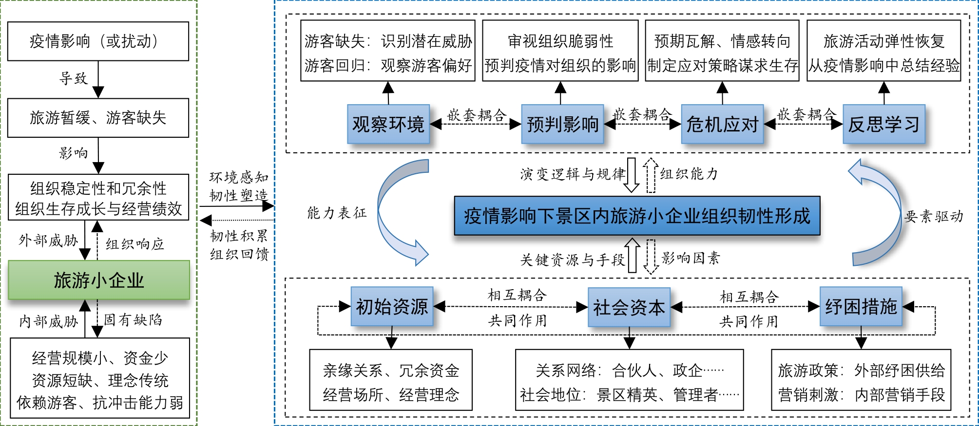
Small tourism enterprises are pivotal in the development and evolution of the spatial dynamics of scenic tourism and are the principal contributors to tourism services and experiences. They constitute a tangible base and medium for developing tourism in scenic areas. However, amidst the challenges of the tourism crisis and disaster management, there is a noticeable deficiency in the theoretical focus and case study analysis concerning small tourism enterprises. This study delves into the effects of the COVID-19 pandemic on the tourism industry and its associated sectors. It emphasizes small tourism enterprises in the Xijiang Qianhu Miao Village scenic region, drawing from case observations and field research alongside comprehensive interviews to gather authentic data. This study utilizes the proceduralized grounded theory to elucidate the inherent principles and mechanisms behind the organizational resilience of small tourism enterprises facing the pandemic's impacts. Additionally, it pinpoints the critical elements influencing the development of organizational resilience in these enterprises. The findings reveal the following: 1) The interplay between organizational capabilities and influential factors collectively elucidates the genesis and robustness of organizational resilience among small tourism enterprises in scenic areas, with resilience emerging and intensifying through the synergistic influence of internal and external organizational elements. 2) Organizational capabilities represent the intrinsic rationale and conceptual framework underlying the development of organizational resilience in small tourism enterprises. Such resilient organizations exhibit fundamental abilities such as environmental observation, impact forecasting, crisis response, and reflective learning. In essence, small tourism enterprises adapt by monitoring and recognizing shifts in the external milieu, predicting the duration and ramifications of the pandemic, and crafting proactive strategies in response to pandemic-induced challenges based on external changes and internal shortcomings. Throughout the pandemic, new insights were assimilated into the operational and developmental strategies of small tourism enterprises through ongoing reflection, summarization, and learning. Prompt adaptations in business approaches contributed significantly to cultivating and reinforcing organizational resilience. 3) Initial resources, social capital, and support initiatives foster organizational resilience among small tourism enterprises in scenic locales. These components are crucial for ensuring organizational survival, enhancing resilience potential, and sculpting organizational resilience. Specifically, foundational resources such as property ownership, operator expertise and skills, and surplus funds are vital for building organizational resilience during a pandemic. Concurrently, the relational networks between small tourism enterprises and their stakeholders, alongside social capital stemming from operators' power dynamics and identity within the tourism context, markedly strengthen organizational resilience. Furthermore, tourism relief policies and interventions that modify tourist influx and business sustainability within scenic areas play a pivotal role in enhancing the resilience of small tourism enterprises. This study broadens the theoretical understanding based on case studies of organizational resilience in small tourism enterprises amid the pandemic. It offers theoretical insights and practical guidance for the ongoing management and adaptive regulation of these enterprises during tourism-related crises and disaster management scenarios.
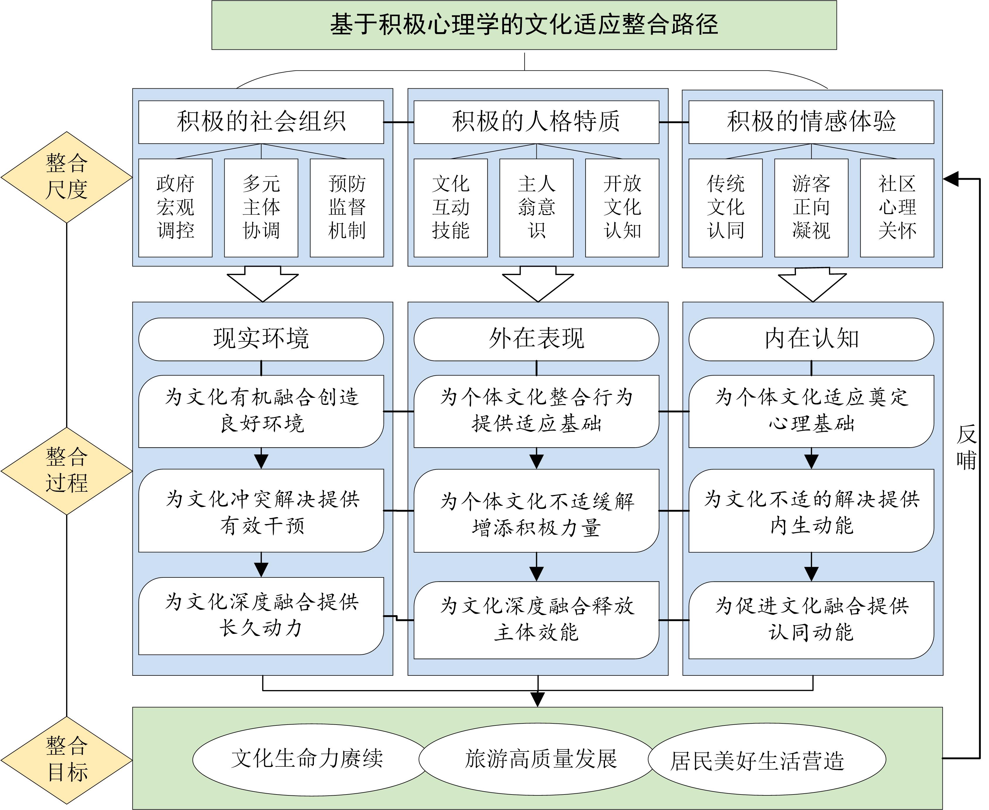
Traditional village culture is an important part of rural culture as well as a precious heritage and historical memory of the Chinese nation, and its effective inheritance and sustainable development have attracted much attention. However, traditional village culture is often in a disadvantaged position in the process of urban-rural cultural exchanges, and the cultural adaptation problem of traditional village residents creates difficulties for the integration of urban-rural culture and the development of traditional cultural inheritance in China. In the context of traditional village conservation and tourism development, the cultural adaptation of traditional village residents is related to the resolution of the contradiction among traditional village development and conservation, the realization of the residents' good life, and the realization of the creative transformation and innovative development of traditional culture. Based on the literature on cultural adaptation, case summaries, and long-term field research experiences, this study clarifies the practical objectives of the cultural adaptation of tourism-driven traditional village residents, refines the process mechanism of their cultural adaptation by combining dimensions and processes, and explores the integration path of cultural adaptation based on positive psychology. The results show that first, the process mechanism of cultural adaptation of the residents of tourism-driven traditional villages can be investigated by combining the context of the evolution of urban-rural relationships in China and the U-curve theory of cultural adaptation. During the period of foreign culture entry, residents' external actions are actively cooperative, although their internal perceptions show foreign culture biases and development opportunity expectations. During the period of cultural clash and adjustment, conflicts and contradictions in daily life and behavioral expressions of residents are frequent, causing negative internal psychological emotions and cultural assimilation. The goal of the cultural integration period is that after a series of conflicts, residents will actively cooperate in their external behavior, and will be able to pass on their culture and seek progress. In terms of internal perceptions, residents will have increased psychological satisfaction, cultural confidence, and positive and open cultural perceptions. Further, borrowing from the research concept of positive psychology, we created a positive social organization system with three aspects: government macro-control, coordination of multiple groups, and a preventive supervision mechanism; a positive personality trait system with three aspects: cross-cultural interaction skills, ownership concept, and flexible and open cultural cognition; and a positive emotional experience system with three aspects: cultural identity, positive gaze of visitors, and community care. Based on the above systems, corresponding countermeasures to be taken at different stages of the cultural adaptation process are proposed to construct an integrated path of cultural adaptation for residents of traditional villages. This study explores the process mechanism and integration path of cultural adaptation of traditional village residents to deepen the interactive logic of locality and cultural adaptation, and provides a scientific reference for community governance and conservation practices in traditional villages, supporting traditional village locality protection and urban-rural integration.
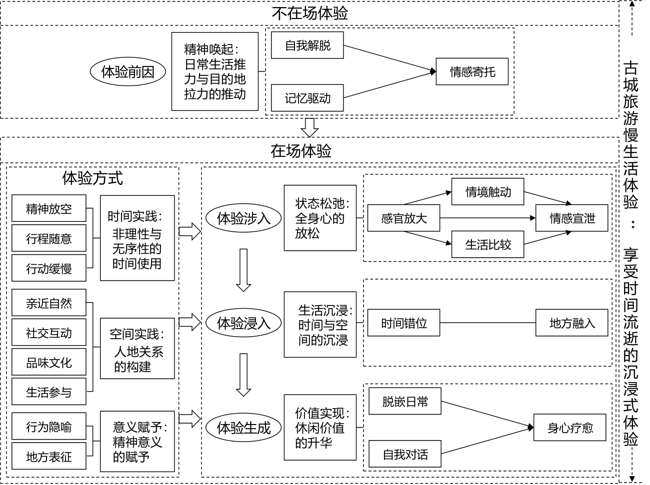
Accelerated development of modern society has harmed people's physical and mental health. It has become a trend to achieve physical recovery and spiritual reshaping through the deceleration of tourism. However, further research is required to understand how consumers experience and realize time deceleration in the context of tourism. In this study, Lijiang acient town, which has the unique charm of a slow-living experience in the eyes of tourists, was selected as the case study, and the text materials of online travel notes and interviews were used. The coding method of grounded theory was adopted to analyze the connotation and occurrence mechanism of the slow-living experience. The results were as follows: 1) The slow-living experience of ancient town tourism is an immersive experience in which tourists visit the tourist destination of the ancient town and enjoy the passage of time under the influence of spiritual arousal of relief needs, memory, and emotion. 2) Time practice, space practice, and adding meaning to life are the main ways of a slow-living experience, which run through the entire process of tourists' slow-living on-site experiences. 3) The slow-living experience of ancient town tourism includes four stages: spiritual arousal, state relaxation, life immersion, and value realization. Each stage is interconnected and promotes the realization of tourists' deceleration experiences. The theoretical value of this study is that through the explanation of the slow-living experience model, the occurrence mechanism of tourists' slow-living experience was discussed in detail, and the core proposition of how tourists experience and realize deceleration was answered. Among them, the slow-living experience emphasizes the drive of spiritual arousal, relaxation of physical and mental states, immersion in life at the time and space levels, and sublimation of leisure value. This realization process differs from other types of tourism experiences. In addition, this article emphasizes that time practice, space practice, and adding meaning to life can create leisure value, emotional value, and a spiritual sense for tourists' time use and promote the depth of tourists' slow-living on-site experience. The research conclusions provide guidance for tourism development of ancient town tourism. Ancient town tourism operators should focus on tourists and formulate targeted programmes according to their behavioral trends. However, the extensibility of slow-living experiences should be considered comprehensively. Operators should consider the influence of other tourist destination landscapes on the slow-living experience, pay attention to the correlation between the two, create a relaxed and lazy slow-living atmosphere for tourist destinations, and stimulate tourists' environmental awareness. This can provide tourists with an excellent slow-living experience and promote the sustainable development of tourist destinations. Overall, starting from the micro level of tourists, this study constructed a slow-living experience model in the context of ancient town tourism, providing a new perspective and practical guidance for a deeper understanding of tourists' experiences.
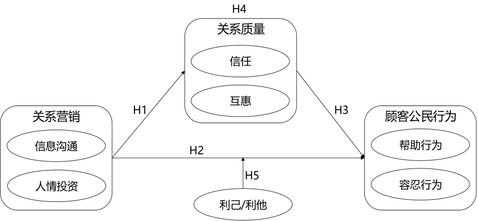
As an emerging form of accommodation in the leisure and vacation era, the relation marketing of homestays is an important factor in promoting a good relation between hosts and guests and stimulating the citizenship behavior of customers. Customer citizenship behavior is necessary to enhance the customer travel experience and promote the high-quality development of the homestay industry. Stimulating customer citizenship through relation marketing is an important scientific issue that needs to be addressed for the high-quality development of homestays. Based on social exchange theory and attribution theory, this study analyzes the relation between homestay staff and customers and refines the two-dimensional structure of homestay customer citizenship behavior, confirming the mediating effect of relation quality on the influence of relation marketing on helping behavior and deepening the understanding of the moderating effect of motivational attribution on the influence of relation marketing on customer citizenship behavior. The influence mechanism of customer citizenship behavior was clarified. The research results show that customer citizenship behavior in the homestay context consists of two dimensions: helping behavior and tolerant behavior, indicating that the structure of customer citizenship behavior in different contexts is still different. Second, the main effects of relation marketing on relation quality and customer citizenship behavior are significant. That is, a homestay can improve the quality of its relation with customers through instrumental behaviors, such as information communication, and emotional behaviors, such as human investment. Customer citizenship behavior is an important behavioral response to relation marketing. Third, relation quality mediates the relation between marketing and helping behavior, indicating that relation marketing promotes customer trust in homestays and understanding the reciprocity of behavior, which in turn promotes customer helping behavior. Fourth, motivational attribution has a moderating effect on the influence of relation marketing on tolerant behavior. This shows that in altruistic motive attribution, the more customers perceive relation marketing, the more they can feel the good experience brought about by homestay staff, so they voluntarily adopt tolerant behavior in the face of service failure, based on the principle of reciprocity in social exchange theory. This study combines the social exchange and attribution theories to explain the mechanism of customer citizenship behavior in the context of homestay services. While enriching the research content of high-quality development of homestay, it constructs a discourse system with more"relation" characteristics for tourism marketing, broadens the tourism application scenarios of relation marketing theory in practice, helps homestay maintain a good relation between host and client, stimulates customer citizenship behavior, and contributes to the development of homestay tourism services and products.
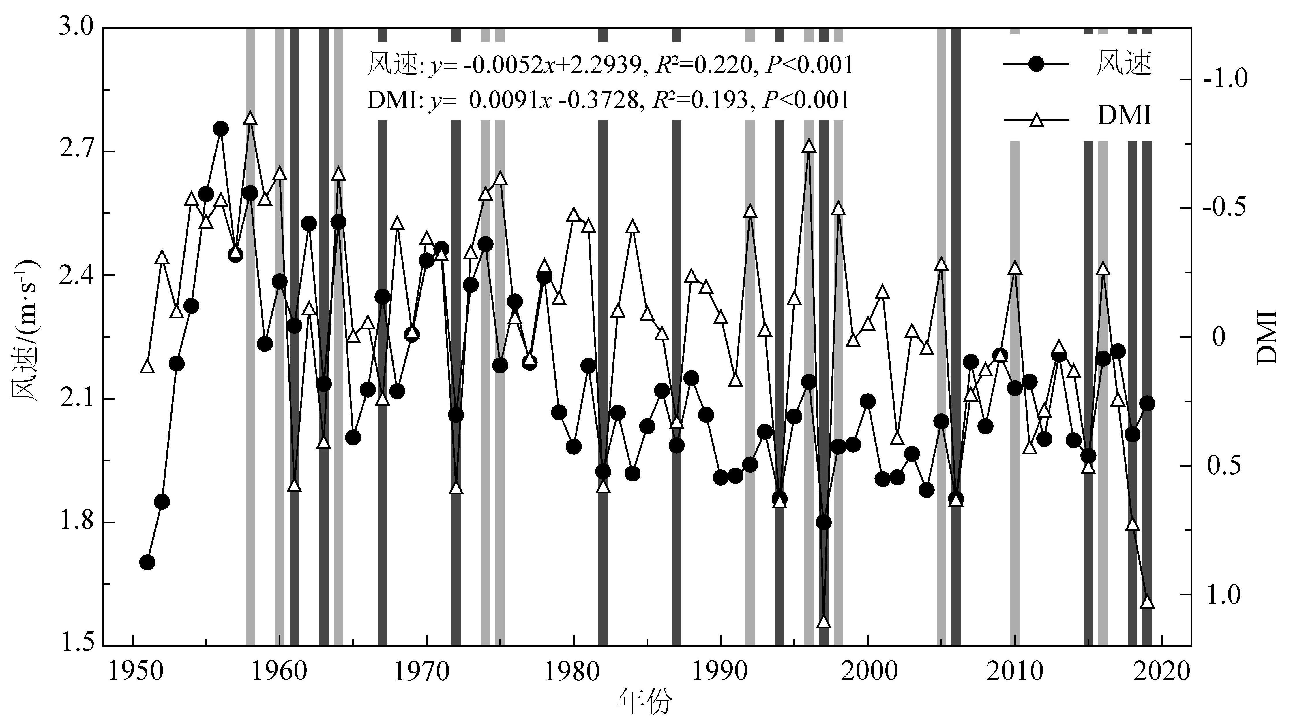
Wind speed is an important parameter reflecting the climate and environmental conditions on the Earth's surface. It is also a pivotal factor influencing wind energy, a renewable and clean energy source. The mechanisms exerting influence on the surface wind speed over China, which have been mentioned in previous studies, include the temperature difference between the high and low latitudes of China, surface drag force, and climatic factors such as the Arctic Oscillation (AO), Pacific Decadal Oscillation (PDO), and El Niño-Southern Oscillation (ENSO). The Indian Ocean Dipole (IOD), which has attracted increasing attention during the past two decades, is an important climatic factor that exerts a significant influence on the climate and environment in the areas surrounding the Indian Ocean and globally. However, to date, it has not been reported whether the IOD is a climatic factor that significantly affects surface wind speed in China. Coastal South China is one of the most economically developed areas in China, and wind energy is becoming an important energy source in this area. An investigation of the relationship between the IOD and wind speed variations in coastal South China and their connecting mechanisms would contribute substantially to the understanding of the controlling mechanisms of climatic and environmental variations in coastal South China as well as to the planning of sustainable development in this area. Based on observations of surface wind speed in coastal South China, reanalysis data from the National Center of Environment Prediction (NCEP) and the National Center of Atmospheric Research (NCAR), research on the IOD over the last two decades, the effects of IOD activities on surface wind speed in coastal South China, and the controlling mechanisms were investigated using statistical analyses and atmospheric circulation variations. The results indicate that, regardless of the temporal or spatial scale, variations in the surface wind speed in coastal South China show significant positive correlations with the dipole mode index (DMI), which is a proxy for IOD activity. An increase in the DMI index (indicating a strengthening of IOD activity) corresponds to a decrease in the surface wind speed in coastal South China, and vice versa. This suggests that, in addition to the factors suggested in previous studies, which include the temperature difference between high and low latitudes, AO, PDO, and ENSO, IOD activity is also one of the most important factors affecting surface wind speed variation in coastal South China. The influence of IOD activity was weaker than that of the temperature difference between high and low latitudes. However, it played a more important role in the surface wind speed variation in this region than the AO, PDO, and ENSO. Strengthening of the IOD activity would enhance two anti-cyclones in the northwest Pacific and Bengal Bay, east of the Indian subcontinent, and, in turn, contribute to the reduction of surface wind speed variation in coastal South China. More serious global warming and increasing greenhouse gas emissions will further strengthen IOD activity in the future. Consequently, a greater decline in surface wind speed is expected in coastal South China, necessitating attention to sustainable wind energy use in this region.
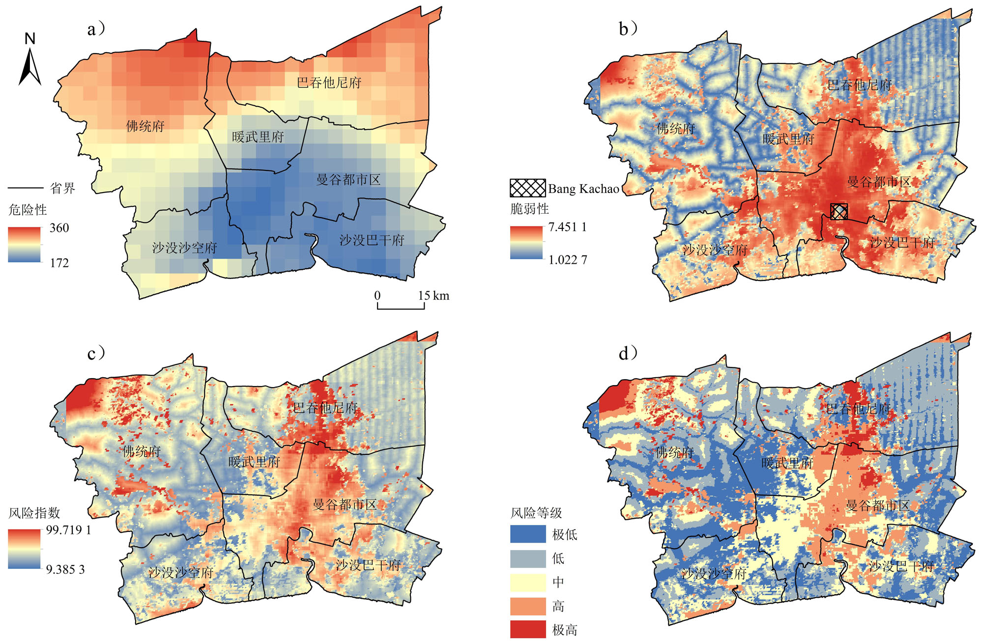
Bangkok is a key city in the framework of the "Belt and Road" initiative in Southeast Asia. However, the economy, agriculture, and ecological environment of Bangkok is now facing significant risks due to frequent drought disasters in recent years, resulting in substantial economic losses. This study is based on the theory of natural disaster risk assessment and evaluates the risk of drought disasters by analyzing the factors causing disasters and the vulnerability of affected areas. We examine the spatial distribution of drought hazard risk, vulnerability, and overall risk in the Bangkok node area from 2000 to 2020, employing univariate linear regression analysis and the Mann-Kendall test to assess changing trends and spatial distribution characteristics. The results showed 41.64% of the land in the study area had a moderate or higher risk of drought disasters, with the highest risk areas located in the northwest of Nakhon Pathom and the central part of Pathum Thani. The risk levels in the region are determined by a combination of vulnerability and hazard factors. Furthermore, the risk, vulnerability, and hazard levels in Bangkok exhibit a linear upward trend. The central urban area of Bangkok has the fastest linear increase in vulnerability and risk and the risk level is increasing most rapidly in northern areas, which differs from the other two indicators. The results of the M-K test indicate that vulnerability in Bangkok's central built-up area is not significant but in the surrounding areas there is a strong upward trend. Notably, there are significant areas of decline in the northwest and southeast for Bangkok's vulnerability. Hazard and risk shows an insignificant rising trend in the east and a decreasing trend in the west. Central Bangkok's drought risk is increasing, highlighting a noticeable spatial distribution difference between the linear trend and the M–K test results. The spatial distribution of risk is influenced jointly by the drought disaster hazard and vulnerability in Bangkok, with vulnerability predominantly determining risk distribution. Finally, The significant increase in drought vulnerability and risk in urban built-up areas warrants close attention for future drought disaster risk management. These areas are currently unsuitable for construction, and efforts should be directed toward reducing their vulnerability to mitigate the risk of drought disasters. The use of fine-scale spatial data for analysis can provide a more detailed understanding of spatial characteristics, accurately reflect a region's water resource management capacity, enhance the rationality of risk assessment, and serve as a valuable reference for research on disaster risk management and risk distribution in node cities.
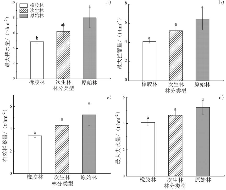
As the final layer for precipitation interception in forests, the litter layer is crucial to the vertical structure of forest ecosystems, situated between the forest vegetation and soil layers. Exploring the litter accumulation and water retention characteristics in different tropical rainforest stands is essential for assessing their water conservation functions. This study focused on three forest stands (primary forest, secondary forest, and rubber plantation) within Qixianling Hot Springs National Forest Park in Hainan, China. The immersion method was used to measure litter accumulation and water retention characteristics, exploring variations among these forest stands. Results revealed (1) significant differences in litter accumulation among the stands, with the primary forest having the highest litter accumulation (2.791 t/hm2), followed by the secondary forest (2.077 t/hm2) and rubber plantation (1.660 t/hm2). Litter moisture content followed the order: primary forest (57.57%) > secondary forest (48.33%) > rubber plantation (46.44%). (2) Regarding water retention and water retention rate, both primary and secondary forests showed an increasing trend with immersion time, with the primary forest exhibiting higher water retention and retention rates than the secondary forest. In contrast, rubber plantations showed no clear trends in water retention or retention rates over time. The relation between litter water absorption rate and immersion time followed a well-fitted power function. The maximum water retention capacities were in the order of primary forest (8.041 t/hm2) > secondary forest (6.251 t/hm2) > rubber plantation (4.896 t/hm2). (3) In terms of water absorption and water loss rates, the rubber plantation had the highest water loss rate, followed by the secondary forest and the primary forest. The maximum water loss was observed in the primary forest (5.225 t/hm2) > secondary forest (4.626 t/hm2) > rubber plantation (4.079 t/hm2), and the maximum water loss rates followed the order: rubber plantation (246.319%) > secondary forest (222.649%) > primary forest (189.748%). The forest litter layer's water retention capacity and storage are closely related, with larger litter reserves correlating with greater water retention. Therefore, among the three forest types, the maximum and effective water interception capacities exhibited the following trend: primary forest > secondary forest > rubber plantation. The maximum and effective interception rates show the pattern: primary forests ≈ rubber plantations > secondary forests. The water conservation function of litter is reflected in its water retention capacity and rate of water loss. Given that primary forests exhibit a higher water retention capacity and lower water loss rates, litter accumulation in primary forests is more conducive to forest water conservation functions. Hence, future efforts should focus on protecting litter from primary forests. Conversely, the litter in rubber plantations tends to have a higher rate of water loss, resulting in poorer water conservation. Therefore, future considerations should include planting understory vegetation in rubber plantations to enhance litter water-conservation capabilities and prevent soil erosion. These findings provide crucial theoretical guidance for forest management and the enhancement of water conservation in tropical regions.
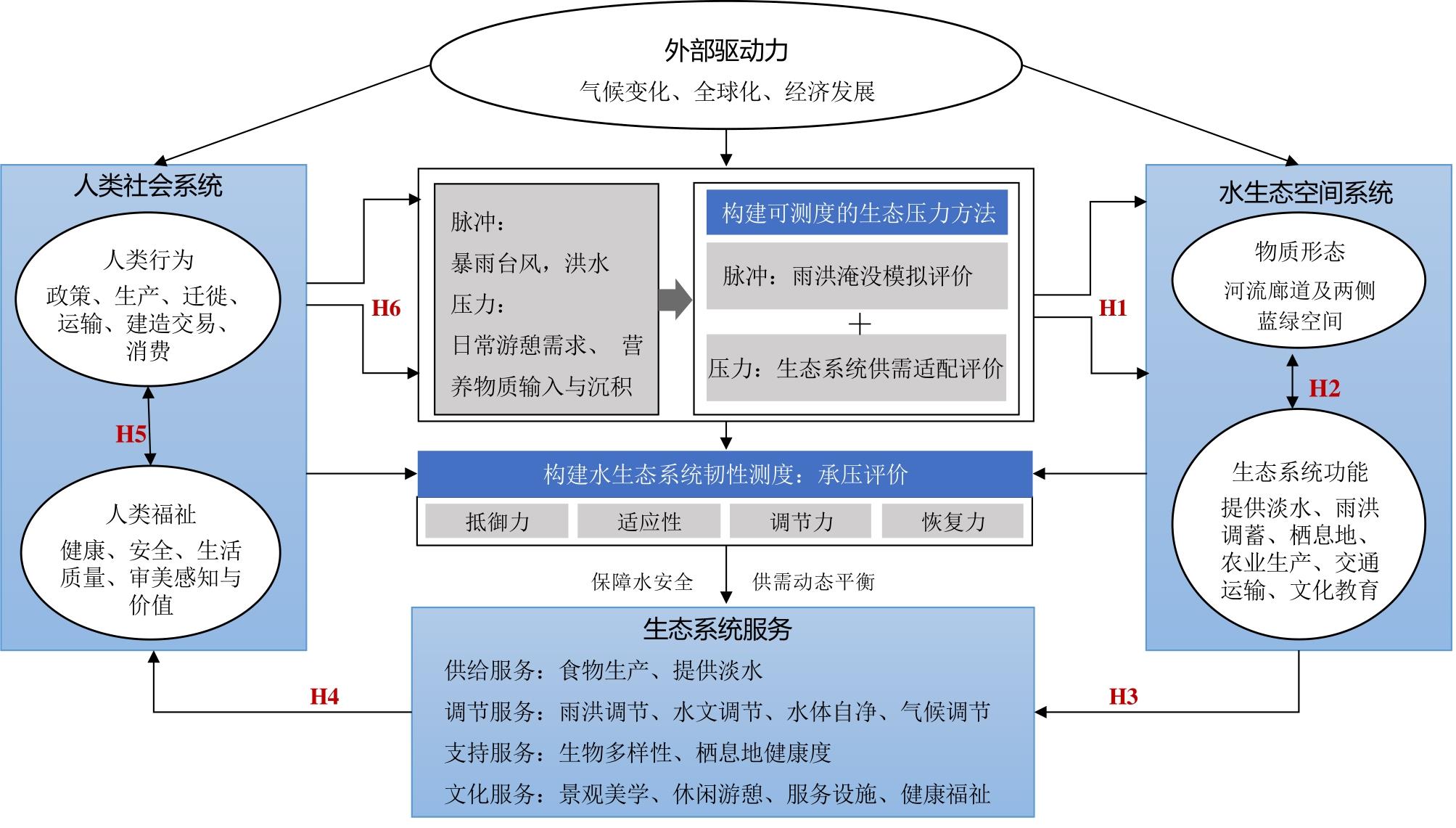
In tropical rainforest regions, rivers face significant challenges from stormwater, flooding, and human activities, making the construction of resilience in their blue-green spaces critical for overall habitat sustainability. While domestic and international studies have focused on resilient flood management practices and quantitative resilience evaluations, there is a lack of assessments specifically addressing the resilience of river blue-green spaces under different ecological pressure impacts. To address this gap, this study incorporates the "pulse" and "pressure" methods into the Pressure-Pulse-Resilience model to measure the resilience of blue-green spaces. This study also develops a theoretical framework for the resilience of aquatic ecosystems by linking societal and ecological factors. The resilience evaluation route consists of four steps: theoretical model construction, pressure-bearing evaluation superposition, analysis of coincidence and conflict points, and resilience planning strategy layout. To achieve the two main objectives of ensuring a balance between water supply and demand for both water security patterns and ecosystem services, this thesis delves into the regulatory mechanisms of river resilience, adaptation, and recovery, providing valuable insights into the spatial resilience planning of rivers in such regions. By focusing on the Nansheng river in Wuzhishan city as a practical case, this study conducted a multidimensional resilience assessment to cope with the frequent occurrence of water security vulnerable zones or the imbalance between the supply and demand of ecosystem services under double ecological pressure. Using advanced simulation methods, such as the SCS-CN model, the Equivalent Factor Approach, and the Hot Spot Analysis Method, the study identified distinct zones that are prone to stormwater and flood inundation, zones at risk of water safety threats, and zones experiencing a mismatch between water supply and demand in the blue-green space. Based on the identification of resilience deficiencies, including multiple stormwater threat zones, an imbalance between supply and demand of ecosystem services, and the seasonal nature of slow pressures, the thesis proposes three planning strategies: first, an ecological security pattern and zoning control approach is suggested based on stormwater and flood pulses to improve the resilience to cope with sudden pulses, following the principle of bottom-line control. Second, a demand-oriented blue-green space planning and service supply strategy was proposed to coordinate the slow-onset pressure on the blue-green spaces of rivers caused by the demands of residents for daily life and recreation, integrating land space and other related planning to balance the supply and demand of the social-ecological system. Lastly, the study advocates for the construction of dynamic and adaptive resilience facilities that cater to the seasonal changes in ecological pressure faced by the blue-green space in tropical rainforest regions, in fulfillment of multidimensional and multilevel water resilience requirements, that is, water security, water ecology, water landscape, water function, and water vitality. In summary, this study presents an innovative theoretical framework for water ecosystem resilience, utilizing the measurable concepts of "pulse" and "pressure." Through an empirical case study of the Nansheng river in Wuzhishan city, this dissertation established a region-specific evaluation path for the spatial resilience of rivers in tropical rainforest areas.
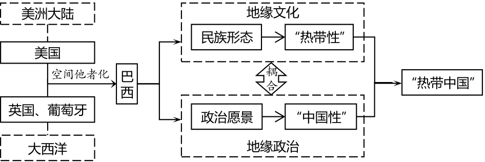
At the height of the national independence movements in Asia, Africa, and Latin America in the first half of the 20th century, postcolonial thought began to emerge in Brazil, reconstructing the self-other relation between Brazil and the West. The imaginative geography of Brazil, one of the most important southern countries, is of great local and global geopolitical significance. In contrast to the general imagination centered on the West and other developed countries, Brazil has the particular imaginative geographies of another large southern country, China. One of the symbolic imaginaries of China in Brazilian scholarship is human geographer Gilberto Freyre's China Tropical, which he likens to China in Latin America. Freyre studied under American geographer and anthropologist Franz Boas, who was a vocal opponent of scientific racism. Therefore, in China Tropical, Freyre advocates for the equality of Brazilian civilization by imagining its structure, continuing Boas's thoughts, and developing a series of postcolonial critiques. This article uses Freyre and his book China Tropical and related thoughts as analysis objectives to explore Freyre's view of Brazil as a tropical China in the process of spatial othering. This study finds that Freyre constructed his postcolonial ideology of Brazil's nation-state development both geo-culturally and geopolitically by imagining Brazil's tropicality and Chineseness. Freyre's portrayal of Brazil as a third space belonging neither to the West nor the East disrupts the colonial hegemony of the discourse of a uniform and homogeneous culture between suzerain and colony and seeks the subversive power of postcolonialism through hybridity and in-betweenness. Second, Freyre conducted an analysis of the human-environment relation in cultural geography from the perspective of historical science, refuted the natural science perspective of environmental determinism, which was prevalent in Western academia at that time, and reshaped the visual balance within the framework of the human-environment relation. This is a side effect of the transformation and change in human geographical thinking. Third, Freyre's concept of tropical China is a prominent achievement in the embryonic period of postcolonial thought in Brazil as well as an important ideological foundation for contemporary Sino-Brazilian exchanges and cooperation. Freyre proposed commonalities and identities between China and Brazil in this field of thought, offering more possibilities for international cooperation beyond human- and poverty-based interactions. This article focuses on the imaginative geographies of former colonial countries, which are conducive to promoting China's understanding of Brazilian society. In addition, we believe that, in the future, Chinese scholarship should pay greater attention to small languages, such as French, Spanish, and Portuguese, which are widely spoken in the former colonial countries of Asia, Africa, and Latin America. With these small language texts at the core, we will continue to study imaginative geographies and country and area studies in Asia, Africa, and Latin America to improve the global understanding of Chinese scholarship.
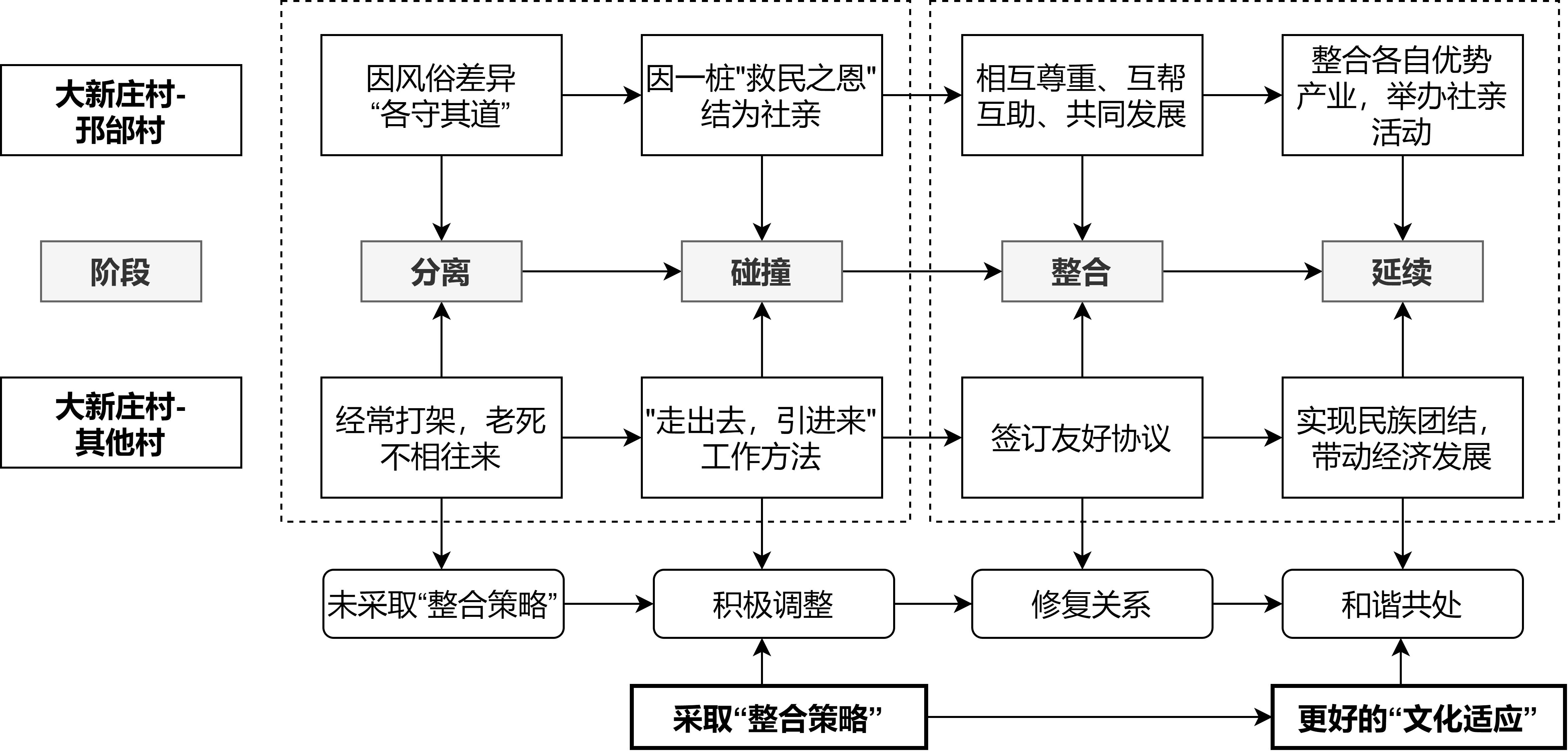
The study of cultural adaptation needs to consider the factors of people and places, and the analysis of "geographical factors" is an important research direction. In order to analyze the causes of social kinship culture and the role of geographical factors in the process of acculturation in the middle and lower reaches of the Yellow River Basin, two groups of acculturation cases were analyzed by using the literature method, participatory observation and semi-structured interviews. The findings show that: (1) the social kinship culture among different groups in northern Henan is formed under a specific geographic scenario of diaspora. The special geographical environment and location are prerequisites for exchange between social kin. Rain praying rituals and common beliefs within a specific radius maintain the ties of social relatives and perpetuate their culture. (2) The two sides follow the cultural adaptation processes of "separation, collision, convergence, and continuity." Integration strategies play an important role in maintaining grassroots unity and achieving social stability in this unique form of cultural adaptation. (3) Different geographical elements play different roles during different stages of cultural adaptation. Spatial and cultural distances must be within a specific range to sustain the culture of social relatives. (4) In scattered and mixed living environments, the culturally similar and different village groups have adopted "integration strategies" to achieve better cultural adaptation, expanding the scope of cultural adaptation in specific scenarios. This study argues that, under similar geographical environment and location conditions, two cultural groups within specific spatial and cultural distances can improve cultural adaptation by exchanging cultural adaptation integration strategies. This study provides a typical empirical case to analyze the geographical factors of cultural adaptation from the perspective of cultural geography, and a deeper explanation of the formation of social kinship culture and its cultural adaptation process. This helps enrich the knowledge and theoretical systems of cultural geography on the relationship between cultural layers.
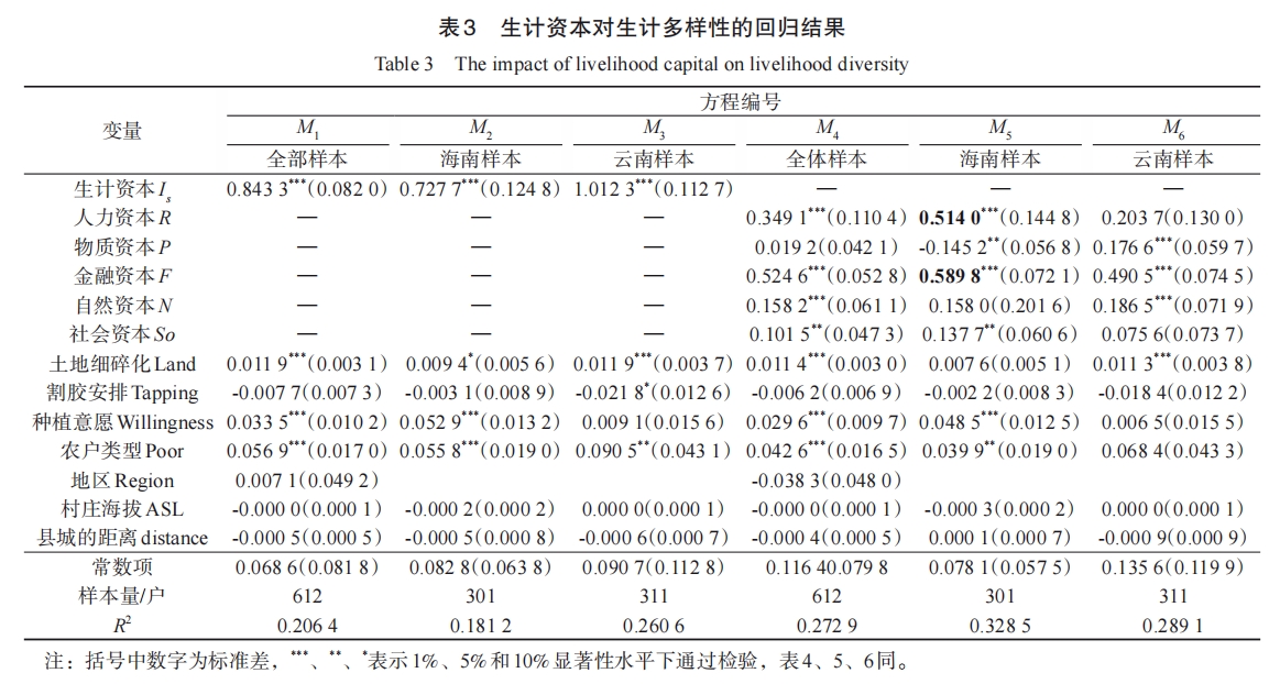
Livelihood capital is the core element of sustainable livelihood development for rural households. Based on the survey data of 615 growers in the main rubber-producing areas of Hainan and Yunnan province, this paper constructs an evaluation system of rubber growers' livelihood capital within the sustainable livelihood analysis framework and calculates key indicators, such as farmers' livelihood capital index, livelihood activity diversity index, and household income diversity index. The multiple regression model and the mediating effect model are used to explore the influence mechanism of livelihood capital on the sustainable livelihood of rural households. The following three conclusions are drawn: (1) The accumulation of livelihood capital of rural households is conducive to enriching the structure of household livelihood activities and income sources, especially the accumulation of financial capital, which is more likely to improve the diversity of household livelihood activities. Regional differences exist in the impact of livelihood capital structures on rural household livelihood outcomes. Natural capital endowment has a significant effect on the income diversification level in Hainan, but there may be a "curse" effect in Yunnan. (2) Geographical characteristics, production decisions, and farming household characteristics significantly impact sustainable livelihoods. The altitude of the village and the distance from the county seat pose certain challenges for farmers in diversifying their livelihoods. Although the law of rubber tapping production may weaken farmers' production and business activities, it can better stabilize farmers' incomes owing to its strong flexibility in labor arrangements, which may be beneficial for diversifying livelihoods; however, it does not necessarily lead to diversified incomes. While the characteristics of poor households can help rural households gain policy support, building capacity is the key to achieving a sustainable livelihood. (3) There are intermediary effects of livelihood capital on livelihood activities and household income, but the mechanisms of action are different. For the diversity of farmers' livelihoods, 52.70% of the catalytic effect of livelihood capital is achieved by improving the ability to integrate livelihood capital. Optimizing household employment strategies contributed to the promotion of livelihood capital on the income diversification index, with a mediating effect of 30.52%. The main contribution of this study is to clarify how livelihood capital can achieve the goal of diversifying household livelihood activities and income by coordinating livelihood capacity and employment strategies. Therefore, to enhance the comprehensive livelihood capacity of rural households, the coordination capacity of livelihood capital, livelihood capacity building should be enhanced, and employment information channels should be expanded.
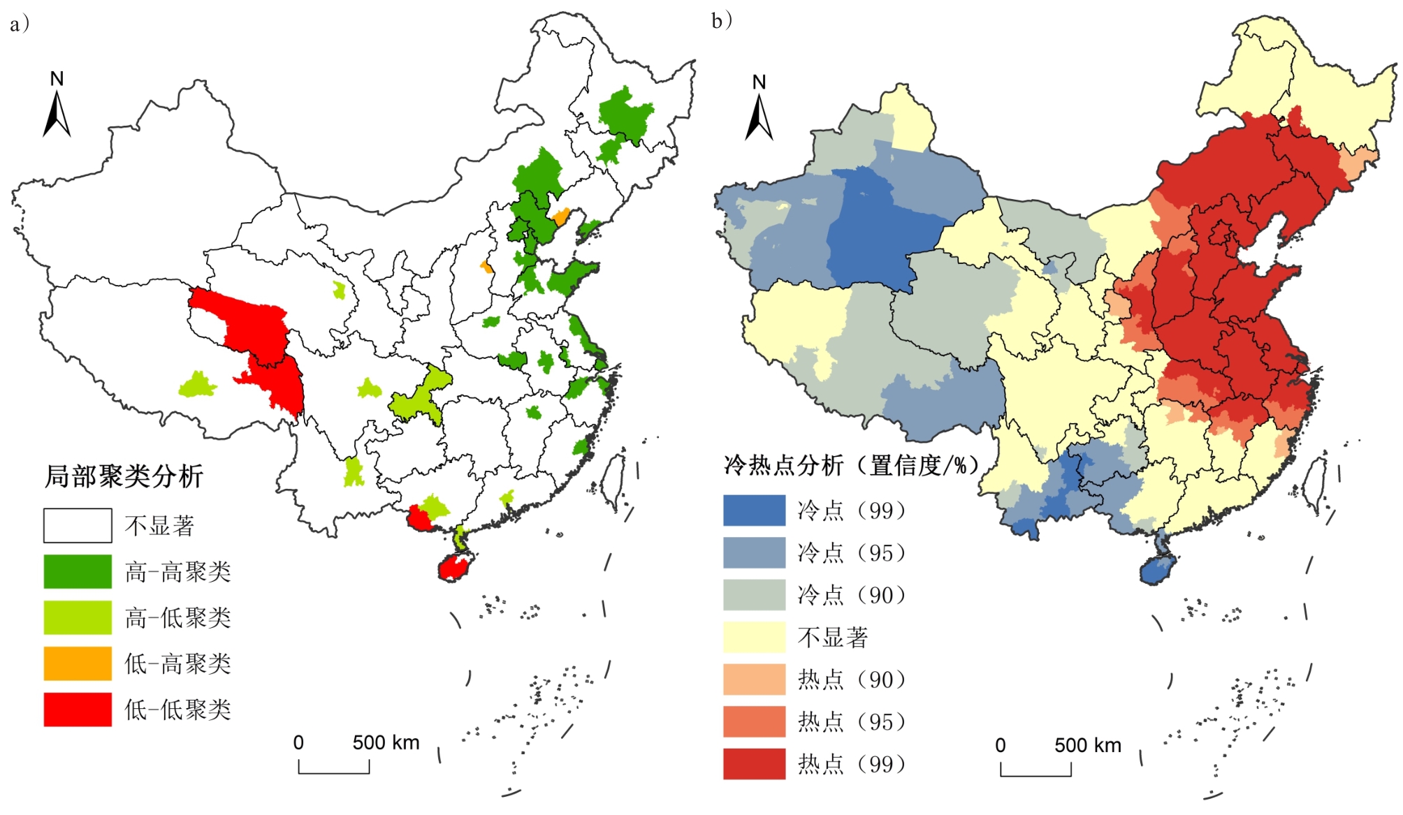
Agricultural brand building has been given greater value and attention in the context of brand strategy and rural revitalization. Previous studies have paid more attention to the role of regional brands and their construction paths. However, as micro-subjects, enterprises also play an important role in the construction of agricultural brands. This article discusses the spatial distribution pattern of Chinese agricultural enterprise brands and its influencing factors through analysis methods such as unbalanced index, spatial clustering test, and negative binomial regression analysis, which could provide a reference for the local construction of agricultural enterprise brands and the promotion of rural industrial revitalization. The present study found that (1) affected by natural resource endowment and economic development, agricultural enterprise brands are most distributed in East China. Shandong, Henan, Jiangsu, and other provinces have the largest number of agricultural enterprise brands. The density of agricultural enterprise brands shows a three-level ladder pattern, with the lowest in the northwest, followed by the central region, and the highest in the eastern coastal region. High-high agglomeration and hot spots have formed in the Yellow River, the middle and lower reaches of the Yangtze River, and the northeastern region, and high-low agglomeration, low-low agglomeration, and cold spots have formed in the western region. (2) The number of regional brands, gross product of primary industry, number of agricultural patents and innovation parks, and number of agricultural anchors are significantly positively correlated with the number of agricultural enterprise brands. The better the agricultural foundation, the stronger the scientific and technological innovation ability; further, the more enterprise brands can adapt and use the new marketing area, the greater the number of enterprise brands that could be constructed. The proportion of the primary industry in the GDP is significantly negatively correlated with the number of agricultural enterprise brands. This is mainly because the higher the proportion of the primary industry in the GDP, the more backward the local economy is to a certain extent, which is not conducive to the development of enterprise brands. The relationship between the number of agricultural experts and corporate brands is not significant; this is because the distribution of agricultural experts is affected by the distribution of agricultural research institutes, and dislocation with the spatial distribution of enterprise brands is observed. In general, in the process of promoting the construction of enterprise brands, localities need to vigorously support agricultural development and regional brand building and focus on the cultivation and flow of innovation as well as the development of new marketing. This study focuses on the distribution of agricultural enterprise brands from the perspective of geography and provides policy recommendations for various places, which has certain theoretical value and practical significance.